Key Takeaways
- A 30 km gate for a tenth of world trade. The Bab-al-Mandab Strait, barely 30 km wide at its narrowest between Yemen and Djibouti, is the southern gate of the Red Sea and the Suez Canal route. Around a tenth of global seaborne trade normally passes through it.
- 8.7 million barrels of oil a day. In 2023 roughly 8.7 million barrels of crude and petroleum products transited the strait each day, according to the US Energy Information Administration, linking Gulf and Asian producers to Europe.
- Houthi attacks emptied the route. After attacks on shipping began in November 2023, most Asia to Europe container lines abandoned the strait and rerouted around the Cape of Good Hope, adding more than 3,000 nautical miles and 10 to 14 days per voyage.
- Still running near half capacity. Into 2025 and 2026, traffic through Bab-al-Mandab remains roughly 50% below its pre-crisis baseline, per IMF PortWatch, with insurance and security surcharges still elevated.
- Twin chokepoints in one region. Together with the Strait of Hormuz, Bab-al-Mandab makes the Red Sea and Gulf corridor the most concentrated cluster of maritime chokepoints on the planet.
Look at a world map of shipping lanes and a handful of narrow passages carry a wildly outsized share of global trade. The Bab-al-Mandab Strait, the slim channel between Yemen and the Horn of Africa, is one of the most important of them all. It is the southern doorway to the Red Sea, the point every vessel must thread to reach or leave the Suez Canal, and since late 2023 it has been at the centre of a shipping crisis that pushed freight rates up around the world.
Its name translates roughly as the “Gate of Grief” or “Gate of Tears”, a nod to the treacherous currents early sailors faced. Today the danger is less about the water and more about who controls the shoreline. Here is what makes this narrow strait so consequential, mapped.
Where is the Bab-al-Mandab Strait?
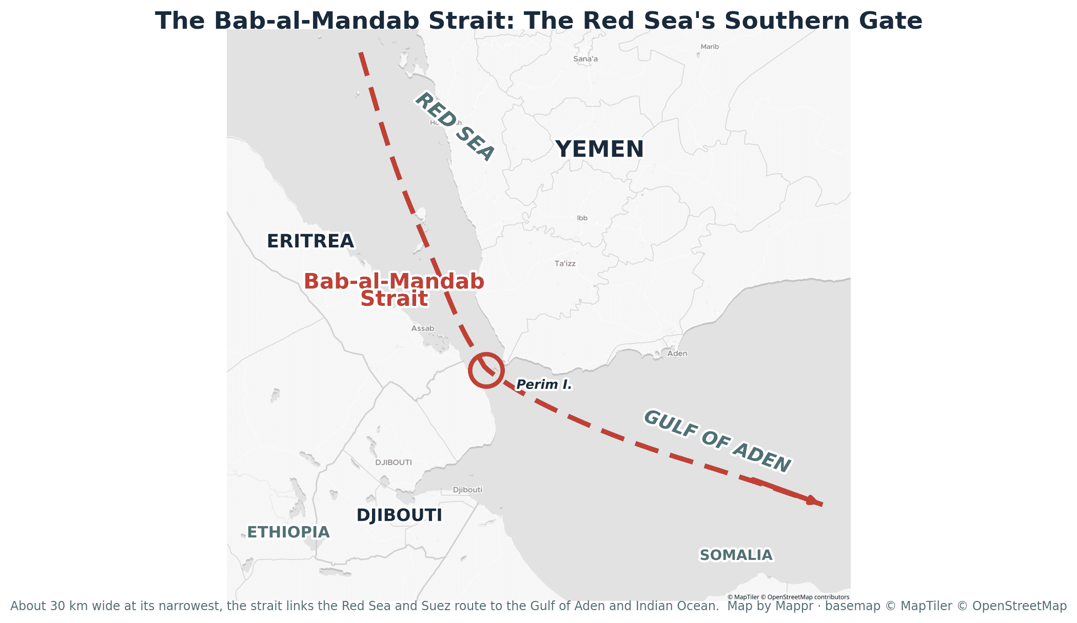
The strait separates the southwestern tip of the Arabian Peninsula (Yemen) from the Horn of Africa (Djibouti and Eritrea). It connects the Red Sea to the north with the Gulf of Aden to the south, which in turn opens into the Arabian Sea and the wider Indian Ocean.
At its narrowest it is only about 30 km wide (roughly 18 miles). The volcanic island of Perim, which belongs to Yemen, sits in the middle and divides the passage into two channels: a wide western channel of around 26 km and a narrow eastern channel of only about 3 km. In practice, tanker and container traffic is funneled into a pair of shipping lanes just a couple of kilometres wide, which is exactly what makes the strait so easy to threaten and so hard to avoid.
Why the strait matters
Bab-al-Mandab is the maritime hinge between Europe and Asia. Almost everything moving by sea from Asia and the Gulf to the Mediterranean and northern Europe, and back again, passes through it on the way to or from the Suez Canal. Estimates vary with what is counted, but roughly 10% to 12% of global seaborne trade normally runs through this single strait.
The energy numbers are just as striking. In 2023 the US Energy Information Administration estimated that about 8.7 million barrels a day of crude oil and petroleum products transited Bab-al-Mandab, most of it heading from Gulf and Asian suppliers toward European markets. Add liquefied natural gas, containers and bulk cargo and you have one of the busiest oil and trade arteries on earth squeezed through a gap narrower than many national parks.
That concentration is the whole point of a chokepoint: it is efficient when open and dangerous when closed. There is no quick alternative. The only way to skip Bab-al-Mandab between Asia and Europe is to skip the Red Sea and Suez altogether and sail the long way around the southern tip of Africa.
The Houthi crisis and the Cape of Good Hope detour
That is exactly what happened. From November 2023, Yemen’s Houthi movement began launching drone and missile attacks on commercial vessels in and around the strait, framing the campaign as a response to the war in Gaza. Insurers and shipping lines reacted fast. By early 2024, UNCTAD estimated that 80% to 90% of container traffic on the main Asia to Europe lanes had been diverted away from the Red Sea.
The alternative is the historic pre-Suez route around the Cape of Good Hope. It works, but it is long: rerouting adds roughly 3,000 to 3,500 nautical miles and 10 to 14 extra days to a typical Asia to Europe voyage, along with the fuel and crew costs that come with them. Suez Canal transits fell by around a third overall in early 2024, and by half or more for container ships, while freight rates on key lanes more than doubled at the peak of the disruption.
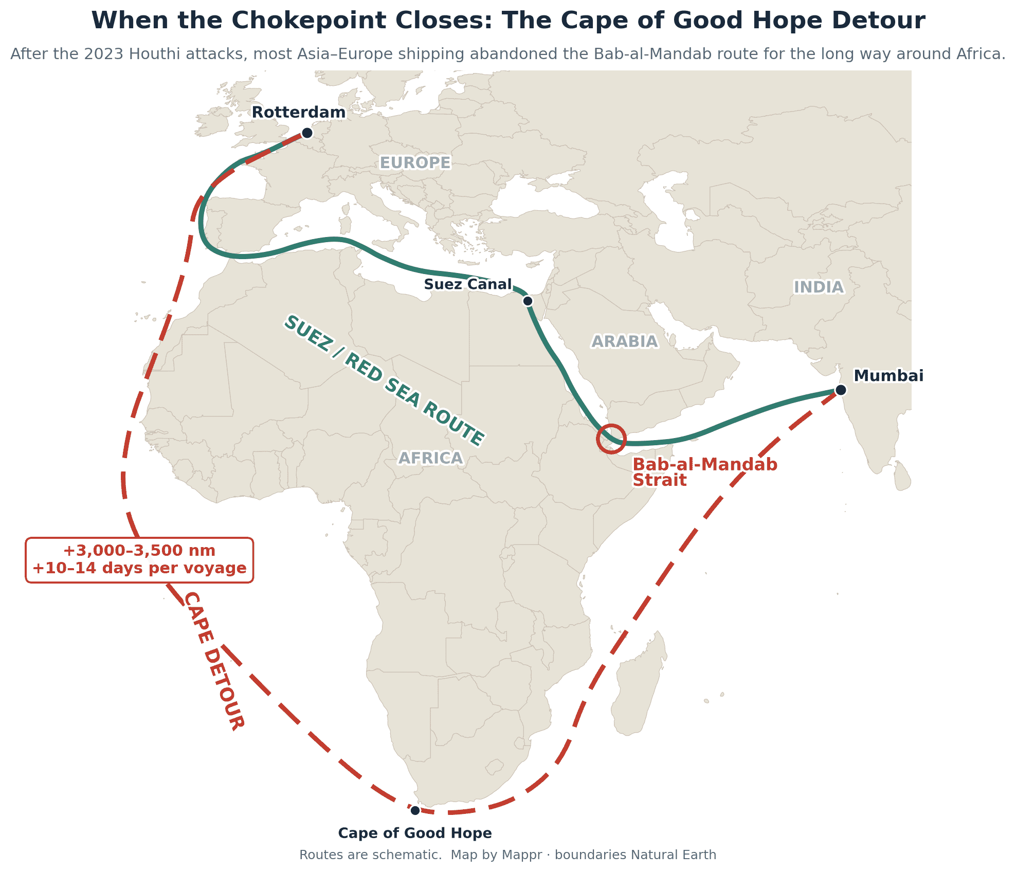
The knock-on effects rippled far beyond the region. Longer voyages tied up ships and containers for weeks, tightened capacity, and fed into higher shipping costs and delivery times for goods across Europe and beyond.
Where things stand in 2026
Traffic has partly returned as some carriers resumed Red Sea transits under naval escort and adjusted their risk calculations. But the recovery is incomplete. Into 2025 and 2026, transit through Bab-al-Mandab and the Suez corridor remains around half of its pre-November-2023 level, according to IMF PortWatch monitoring, and a meaningful share of Asia to Europe traffic still prefers the longer but safer Cape route. Insurance premiums and security surcharges for Red Sea passages stay elevated.
The strait also sits inside a wider web of tension. It is the second of two great chokepoints in the same neighbourhood, alongside the Strait of Hormuz at the mouth of the Persian Gulf. When strikes are traded between the United States and Iran, or when the Houthis renew their threats, oil prices twitch and shipping desks reach for their contingency plans, because two of the world’s most important tankers-per-day corridors run within a few hundred miles of each other. A narrow gap of water off the coast of Yemen, in other words, still helps set the price of fuel and the cost of a container half a world away.
Figures on transit volumes, rerouting and geography are drawn from the following sources:
Image Sources