The centre expects the Khowai, the Manu and the Dhalai to keep falling for three more days. All three are running below danger level.
The damage behind the breach is now being counted. Around 5,000 people were left waterlogged in Habiganj Sadar, some 4,000 of them in Laskarpur union, with three shelter centres opened and 10 tonnes of rice allocated.
The upazila’s own count is larger. Habiganj Sadar UNO Abdullah Abu Zaher put it at about 4,500 families across 22 villages, among them Dakshin and Uttar Charhamua, Kaliganj, Sughar, Adyapasha, Noabad, Hatirthan, Katiadi, Baidyer Bazar and Bangaon.
A third figure is in circulation. The state news agency’s report of the water minister’s visit gave 30 villages and 50,000 people, but those are the numbers local campaigners attach to the 9 July breach at the same spot, not to this one.
The Department of Agricultural Extension puts 125 hectares of standing Aush paddy under water, along with 95 hectares of transplanted Aman, 22 hectares of Aman seedbeds and 25 hectares of vegetables.
Of the Tk 88 lakh released for the repair, about Tk 30 lakh had been spent when the embankment gave way. The MP for Habiganj-3 inspected the work that morning and said he was dissatisfied with its quality.
Dhaka sent a minister after it. State Minister for Water Resources Farhad Hossain Azad inspected the Kaliganj breach on 25 August, saying he had come on the prime minister’s instruction to find a permanent solution.
The immediate repair will be made with geo-bags. Longer-term work to stop Habiganj town flooding is promised, but only once the monsoon is over. The deputy commissioner, local MPs and the Water Development Board’s executive engineer went with him.
As the waters pull back, the first official damage assessments are landing. In Chattogram district alone, the district administration counts 6,020 houses destroyed and 9,208 damaged, along with 405 educational institutions, some 1,592km of roads and 169 bridges and culverts; all evacuees have now returned home from the district’s 670 shelters, and the government has allocated 1,200 tonnes of rice for relief. The blow to farming is severe: the Department of Agricultural Extension says flooding submerged and damaged Aus paddy on 9,043 hectares and summer vegetables on a further 5,907 hectares in Chattogram, too late in the season to replant, and officials have proposed free seed for affected farmers ahead of Aman planting in October.
The agricultural toll is not confined to Chattogram. The Ministry of Agriculture’s Department of Agricultural Extension says the monsoon flooding has now damaged crops across 43 districts nationwide, on a total of 114,723 hectares, with 107,845 hectares (nearly 90 percent) concentrated in 16 districts. Nationally, an estimated 79,500 hectares of Aus rice, 10,504 hectares of Aman seedbeds and 17,800 hectares of seasonal vegetables have been damaged; in Cumilla district alone, crops on 19,899 hectares were affected.
On 27 July the ministry published what it describes as its final assessment of the 7 to 19 July rains. It counts more than 243,000 farmers hit across 43 districts, with roughly 134,000 tonnes of crops worth about Tk 478 crore damaged on 24,138 hectares, close to 3 percent of the 817,000 hectares under cultivation.
Of that damaged land, 12,783 hectares were Aus paddy, 1,746 hectares Aman seedbeds and around 9,000 hectares vegetables, alongside ginger, chilli, turmeric, papaya, jute, banana and sugarcane. The ministry’s final damaged-area figure is far lower than the interim count of 114,723 hectares reported earlier in July.
Rehabilitation money has been approved for seven worst-hit districts: Brahmanbaria, Habiganj, Chattogram, Cox’s Bazar, Rangamati, Bandarban and Khagrachhari. Some 63,000 farmers there have already been given late-variety Aman seed to replace lost Aus crops and seedbeds, with help for the rest promised before the winter cropping season.
In the north the next crop is going in more or less on schedule. The Department of Agricultural Extension said on 30 July that Aman seedlings had been transplanted on 267,267 hectares in the Rangpur region, 43 percent of a 621,550-hectare target.
That region covers Rangpur, Gaibandha, Kurigram, Lalmonirhat and Nilphamari, the districts squeezed by the Teesta’s July rise. Officials say late-variety seedbeds on highland and floating seedbeds in low-lying areas were readied in case August brings fresh flooding.
The repair bill for the roads
The Roads and Highways Department has put a price on its share of the damage. Its Summary of Flood Damage report, reported on 27 July, seeks Tk 378 crore to repair 213km of flood-damaged road across six road divisions in five southeastern districts.
That splits into Tk 45.87 crore for short-term repairs and Tk 332.37 crore for long-term rehabilitation. District highways account for 145.91km of the damaged network, against 34.09km of national highways and 32.95km of regional highways.
Chattogram South, covering Banshkhali, Satkania, Lohagara and Chandanaish, is worst hit at 73.08km, followed by Bandarban at 56.63km plus five bridges and a culvert, Chattogram at 52.77km, Cox’s Bazar at 15.34km, Khagrachhari at 11.73km and Rangamati at 3.39km. Emergency repairs have already started.
The prime minister goes to Chattogram
The government response is about to get its most visible outing. Prime Minister Tarique Rahman will visit three flood-hit Chattogram upazilas, Hathazari, Fatikchhari and Banshkhali, on 9 August.
He is due to distribute relief, hand over 100 newly built houses to families displaced by the floods, and address a public gathering in West Banshkhali. His press secretary says it is his first official trip to Chattogram since taking office.
By 8 August the preparations were done. The district administration has the houses finished and a helipad ready, with the prime minister due to arrive by helicopter in Banshkhali’s Baharchhara union before moving on to Fatikchhari and Hathazari.
He went on 9 August, leaving Tejgaon at 9:15am and landing at Matarbari in Maheshkhali around 11:30am, where he inspected the deep-sea port, the coal-fired power project and the Maheshkhali Integrated Development Authority.
He reached West Banshkhali, in Baharchhara union, at about 1:20pm and handed over the keys to 100 newly built houses for families whose homes were destroyed in July’s rain and hill runoff. He also distributed relief and planted a mahogany sapling.
Each house has two rooms and an attached toilet, built on RCC pillars with timber and corrugated iron sheet for disaster resilience, and paid for with government funding. The handover was part of a rehabilitation event on the Banshkhali High School and College ground.
He then stopped at madrasas in Fatikchhari and Hathazari before a rehabilitation programme at Hathazari Government College, where 30 flood-hit families were due Tk 100,000 each to rebuild and 15 people with disabilities Tk 10,000 each.
Travelling with him were Finance Minister Amir Khasru Mahmud Chowdhury, Home Minister Salahuddin Ahmed, Disaster Management and Relief Minister Asadul Habib Dulu and State Minister for Power and Energy Anindya Islam Amit. He flew back to Dhaka from Shah Amanat International Airport at 10:20pm.
Beyond the southeast: Bogura and Manikganj
The damage is not only southeastern. In Bogura, in the north, weeks of monsoon rain and upstream river flows have destroyed crops worth more than Tk 50 million on about 517 hectares, hitting close to 5,000 farmers, the Financial Express reported on 28 July.
Upstream water has inundated 16 unions across seven of the district’s 12 upazilas. The local weather office says this monsoon has already run 195.3mm wetter than last year, with 309mm falling in the first 10 days to 13 July.
Relief so far is Tk 500,000, an amount agriculture officials call insignificant against the scale of the loss. A full assessment is still being prepared, and officials warn of a summer vegetable shortage in the north unless seed, fertiliser and cash reach farmers quickly.
In Manikganj, in central Bangladesh, flash floods damaged crops on 222 hectares and hit 4,885 small and marginal farmers, the state news agency BSS reported on 29 July. The district took at least 301mm of rain between 4 and 10 July.
The Department of Agricultural Extension has filed a damage report and the local administration a second one. Agriculture Secretary Rafiqul I Mohamed said the government would decide promptly on assistance and incentives for flood-affected farmers nationwide, Manikganj included.
A UN inter-cluster situation report published on 23 July put firmer numbers on the damage. Across the seven worst-hit districts, 1.28 million people are affected, including more than 15,500 people with disabilities, and roughly 436,000 need humanitarian assistance. Government assessments count 74,479 houses damaged or destroyed, plus 29,076 water points and 36,550 latrines damaged across 42 upazilas in six districts, a water and sanitation failure that compounds the diarrhoea risk already showing up in Chattogram’s hospitals. Some 27,007 hectares of cropland in those districts were hit and more than 266,000 livestock affected, with combined livestock and fisheries losses put at $17.3 million.
A separate post-flood assessment by the Department of Livestock Services, reported on 24 July, sets the animal toll in the Chattogram region at Tk 771.5 million (Tk 77.15 crore). It counts 161,394 animals killed, among them 158,600 chickens, 2,508 ducks, 165 goats, 71 cattle and 50 sheep, across 191 unions in 45 upazilas of five districts. Some 10,991 farms were affected, 4,756 of them livestock farms and 6,235 poultry farms, and a further 223,390 cattle, 4,755 buffaloes, 160,087 sheep, 2.85 million chickens and 70,370 ducks fell sick and are being treated. Chattogram district alone accounts for Tk 600.68 million of the losses, ahead of Cox’s Bazar at Tk 135.39 million, Rangamati at Tk 29.98 million, Khagrachhari at Tk 3.7 million and Bandarban at Tk 1.75 million. Lost animal feed, 910 tonnes of concentrate, 14,265 tonnes of straw and 9,129 tonnes of grass, is valued at close to Tk 350 million.
The view from Banshkhali
On 28 July the Guardian set Bangladesh’s floods alongside a band of extreme rainfall running from Afghanistan to Taiwan, reporting from Banshkhali, one of the Chattogram upazilas swept by the early-July flash flood.
Jesmin Akter carried her six children through chest-deep water to her mother’s house and stayed there for more than a week. Her poultry died, her paddy field flooded and the house the family had repaired months earlier collapsed.
They are back in the ruins now, sleeping on plastic sheets and living on aid, with one daughter already running a fever. In eastern Afghanistan the same run of storms killed at least 31 people last week and left hundreds missing.
The bottom line
This is a disaster of geography and circumstance combined: record rain falling on cleared hillsides where a million of the world’s most vulnerable people have nowhere safer to go, at the exact moment the money to protect them is being cut.
The monsoon has months left to run. The seven-day stretch with no station in the country above its danger level ended on 23 August, when the Khowai went 130cm over at Ballah.
On 26 August none of the 127 is over the line for a second day, with 47 rising against 77 falling and three steady.
The watch has not lifted, but the upstream rain has. The Meghalaya burst of 25 August, 175mm at Mawkyrwat and 132mm at Cherrapunji, was down to 57mm at Cherrapunji in the 24 hours to 9am on 26 August, with 62mm at Siliguri the only other station listed.
The low that formed over the northwest Bay on 23 August has kept moving away. By 26 August it had tracked northwest from Jharkhand to northeast Madhya Pradesh, with the monsoon trough running from Gangetic West Bengal to Assam across southern Bangladesh.
The monsoon is rated fairly active over Bangladesh and moderate over the North Bay. Moderate to moderately heavy rain is still forecast over Sylhet, Mymensingh, Rangpur and Chattogram for another three days, heavier upstream.
The Met Office’s 26 August bulletin repeats it: rain at many places over Rangpur, Mymensingh, Barishal, Chattogram and Sylhet and a few places over Rajshahi, Dhaka and Khulna, with moderately heavy falls possible.
The tail of its five-day outlook is heavier. From 29 August it puts rain across all eight divisions with moderately heavy to heavy falls at places, and says rainfall activity should continue beyond that.
Its own network has eased further: the heaviest fall of the previous 24 hours was 31mm at Sylhet. Tuesday’s national high was 35.7C at Chuadanga and Wednesday morning’s low 24.2C at Sylhet, with temperatures expected to slip.
The Khowai at Ballah is further under its danger mark, by 105cm on 26 August. Behind it the Kushiyara sits 34cm under at Fenchuganj and 45cm under at Markuli, with the Teesta at Dalia 52cm under.
The coastal rivers of Barishal, Khulna and Chattogram are still off a normal tide. On 26 August the centre again reports a higher than normal tide on the Kirtonkhola, Lower Meghna, Pashur, Ichamati, Karnaphuli, Little Feni and Noakhali Khal, and again expects it to hold two more days.
Data and references (as of 26 August 2026):
Image Sources





Key Takeaways
- At least 59 dead, 1.28 million affected. Days of intense monsoon rain have triggered flooding and landslides across southeastern Bangladesh. A UN inter-cluster situation report dated 23 July puts the toll at 59 dead and 1.28 million people affected across seven districts as of 22 July, with about 436,000 needing humanitarian assistance and 268,000 households cut off.
- The Rohingya camps were hit hardest. In the Cox's Bazar refugee camps, landslides and a collapsed retaining wall killed at least 17 people, most of them children. Thousands of shelters were destroyed and more than 20,000 refugees were relocated from the most dangerous slopes.
- A record-breaking downpour. Chattogram recorded 412mm of rain in 24 hours on 7 July, its heaviest in 43 years, bringing the city to a standstill and saturating the hillsides that then gave way.
- Deadly by design. The camps are a maze of bamboo-and-tarpaulin shelters clinging to steep, deforested hills. With the tree cover long cleared and the soil saturated, the slopes collapse under heavy rain.
- Aid cuts have deepened the danger. The 2026 humanitarian appeal for the Rohingya is 26% smaller than last year, and the World Food Programme faces a shortfall of about $147 million. UNHCR says the funding cuts have directly heightened the monsoon risk.
Days of relentless monsoon rain have turned the hills and floodplains of southeastern Bangladesh into a disaster zone. As of the Joint Needs Assessment published on 29 July 2026, the toll stands at 59 deaths across the seven worst-hit districts and 1.28 million people affected, around 436,000 of them needing humanitarian assistance.
The sprawling Rohingya refugee camps around Cox’s Bazar have borne the heaviest human cost. As of 25 July the government reports the situation improving across both the southeast and the northeast, with Chattogram still the worst-hit district.
That was the picture in late July. Floodwaters had receded in Habiganj with no families left stranded, the Sangu and Matamuhuri were running below danger level in Bandarban, and displaced residents were returning home from the shelters.
The emergency itself is over. The rain that killed 59 people and reached 1.28 million across the seven worst-hit districts in July has gone: on 8 October none of the 127 monitored gauges was above its danger level, and the monsoon had begun to withdraw.
One caveat sits in the forecast. The Met Office expects a low pressure area to form over the Central Bay within five days and has flagged the chance of a cyclone in October or November, but that would be a new event, not this one.
As of 8 October the country is still under its lines. Every one of the 127 monitored gauges is below its danger mark in the Flood Forecasting and Warning Centre’s 9am bulletin for 8 October, and its summary that morning counts no station, no river and no district over the monsoon danger level.
It has been weeks since that changed. The centre’s 9am bulletin last carried one of the 127 monitored stations above danger level on 17 September, at Barishal, and the count reads zero again on 8 October.
It is the Kirtonkhola at Barishal, reading 2.47 metres against a 2.10-metre danger mark, 37cm over after a 95cm rise in a day. This is a tidal reach on the coast, not a hill river in spate.
The centre’s 5-day forecast that morning has the Ganges and the Padma falling all week, the Brahmaputra-Jamuna close to steady into 20 September, and the Surma-Kushiyara dropping away fast.
It expects rises in the northeastern Meghna basin and in the southeastern hill rivers as well, but says none of them is likely to turn into a major flood.
The Khowai at Ballah is still well down. It sits 127cm below its 21.20-metre mark at 19.93 metres after a 41cm rise in the 24 hours to 9am on 17 September, with the Habiganj gauge up 10cm to 5.05 metres and 4.00 metres under.
The 27 August reading was the third straight day with that list empty. A week on it is still empty, but the rivers underneath it have started to fill again.
The Khowai at Ballah went back under overnight. It fell another 82cm to 20.50 metres on 25 August, leaving it 70cm below its 21.20-metre mark two days after cresting 130cm above it.
The balance keeps tipping. From 65 gauges rising and 58 falling on 24 August, the count went to 53 rising against 71 falling on 25 August, 47 rising against 77 falling on 26 August, and 39 rising against 79 falling with nine steady on 27 August.
The balance has tipped back again. On 17 September the centre counts 39 gauges rising against 81 falling and seven steady, with no gauge closed and no reading missing.
The rain that did it came from over the border. Amarpur in Tripura took 68mm and Kumarghat 51mm in the 24 hours to 9am on 22 August, and that runoff came straight down the Khowai into Habiganj a day later.
The upstream falls have since trebled over Meghalaya. Mawkyrwat took 175mm in the 24 hours to 9am on 25 August, against 58mm a day earlier, with 146mm at RKM Sohra, 134mm at Mawsynram and 132mm at Cherrapunji.
They dropped back just as fast. The centre’s notable-rainfall list for the 24 hours to 9am on 26 August carries only two upstream stations: 62mm at Siliguri in West Bengal and 57mm at Cherrapunji, down from 132mm there a day earlier.
Shella in Meghalaya added 50mm and Belonia in South Tripura 71mm. The Meghalaya falls drain into the Surma and the Jadukata, which rose 26cm at Chhatak and 65cm at Lorergarh, while the Tripura rain went into the Muhuri, up 60cm at Parshuram.
The Khowai at Ballah jumped 140cm in a day to 20.95 metres on 22 August, leaving it 25cm under its 21.20-metre danger mark. It went over the next morning.
On 23 August the gauge read 22.50 metres, 130cm above the line, and the embankment below it failed. By 24 August the river had fallen 118cm to 21.32 metres, still 12cm over.
On 27 August the Khowai at Ballah is 130cm below its danger mark, at 19.90 metres after another 25cm came off the gauge. The Habiganj gauge downstream fell 19cm to 5.31 metres.
The forecast has changed with it. The centre now expects the Khowai, the Manu and the Dhalai to hold steady for the next three days rather than keep falling, all of them below their danger marks.
Behind it the Kushiyara has loosened again: 41cm under its danger mark at Fenchuganj in Sylhet and 50cm under at Markuli in Sunamganj on 27 August, against 34cm and 45cm a day earlier.
That slack is not expected to last. The centre reads the Surma and Kushiyara as falling over the 24 hours to 9am on 27 August, but expects them to rise for a day before holding steady for two.
Both stations are still logged at warning level in the 27 August forecast summary, the step below danger. The Teesta at Dalia has now joined them, up 15cm to 51.78 metres.
That leaves the Teesta 37cm under its 52.15-metre danger mark, the tightest margin on the 127-station network. It is also the one river the centre expects to keep climbing.
The Teesta has eased at the barrage. On 17 September it reads 51.80 metres at Dalia after a 12cm fall, 35cm under its 52.15-metre mark.
Downstream it is the other way round. Kaunia rose 22cm to sit 35cm under its mark and Tarapur 15cm to sit 41cm under, and the centre expects both to climb to within about 17cm of their danger levels by 20 September.
The other northern rivers are quieter. The Dudhkumar rose 29cm at Pateswari to sit 1.51 metres under its mark, while the Dharla fell 9cm at Kurigram and is 2.24 metres under.
There is a complication upstream. A landslide above the Chyakoong river in North Sikkim on the night of 5 to 6 September partly blocked that river and the Teesta, though Sikkim officials say the Teesta is flowing normally and there is no immediate flood threat downstream.
The northeast has drained away instead. The Kushiyara at Fenchuganj is 51cm under its 9.45-metre danger mark on 17 September after a 10cm fall, with Markuli 56cm under after a 5cm fall.
Upriver the fall is steeper. The Kushiyara lost 34cm at Amalshid and 25cm at Sheola in the 24 hours to 9am on 17 September, with the Surma down 39cm at Kanaighat and 27cm at Sylhet. The centre expects both rivers to keep falling for three days.
The rain has moved off the border and inland. Dakhinbagh took 100mm in the 24 hours to 9am on 17 September, with 93mm at Derai in Sunamganj, 72mm at Sunamganj and 71mm at Pateswari in the north.
The southeastern hill rivers took the next jump. The Feni rose 160cm at Sonapur and 112cm at Shuvopur in the 24 hours to 9am on 17 September, with the Halda up 152cm at Panchpukuria and 134cm at Narayan Hat.
None of them is near trouble. The Feni is still 2.65 metres under its mark at Sonapur, the Halda 4.60 metres under at Panchpukuria and the Sangu 8.95 metres under at Bandarban.
Upriver the rise is bigger: the Kushiyara is up 18cm at Amalshid and 15cm at Sheola, with the Surma up 10cm at Kanaighat and 11cm at Sylhet. All four are still more than a metre under their marks.
The centre reads the Teesta and the Dudhkumar as rising and the Dharla as falling, and expects the three to rise for another two days before holding steady on the third.
Inside Bangladesh the gauges did not stay quiet. After 52mm at Brahmanbaria on 22 August, the same station took 136mm in the 24 hours to 9am on 23 August, the national high, with 85mm at Latu and 53mm at Lalakhal.
It eased again the next day. The notable falls in the 24 hours to 9am on 24 August were 54mm at Noakhali and 48mm at Lalakhal in Sylhet, with 44mm at Sunamganj and 44mm at Lorergarh.
Then it came back hard. In the 24 hours to 9am on 25 August Maheshkhola in Sunamganj took 154mm, the national high, with 75mm at Feni, 68mm at Lorergarh and 50mm at Sunamganj town.
The same station led again on 26 August, at 96mm, and this time it was the only place in the country to clear the centre’s notable-rainfall threshold. The next heaviest was 31mm at Sylhet.
On 27 August the rain moved to the tea districts. Sherpur-Sylhet, in Moulvibazar, took 112mm in the 24 hours to 9am, very heavy on the centre’s own scale and again the only fall in the country to clear its threshold.
Upstream the list is blank. The centre logged no significant rainfall at all across Sikkim, Arunachal, Assam, Meghalaya and Tripura that morning, after two upstream stations on 26 August and four on 25 August.
The day before, the rain had swung inland to the tea districts. Manu Railway Bridge in Moulvibazar took 95mm in the 24 hours to 9am on 21 August, the heaviest fall on the network, with 63mm at Kanaighat and 58mm at Srimangal.
Behind them came 56mm at Lama in Bandarban, 50mm at Kamalganj in Moulvibazar and 50mm at Dalia in Nilphamari. Upstream it fell harder still: 89mm at Kailashahar in Tripura and 76mm at Cooch Behar in West Bengal.
That follows the border-hills burst of the day before, when Lalakhal in Sylhet took 105mm in the 24 hours to 9am on 20 August, with 77mm at Kanaighat and 50mm at Maheshkhola in Sunamganj.
The coastal southeast has woken up. Teknaf logged 43mm in the 24 hours to 9am on 24 August and Cox’s Bazar 39mm, against zero at both two days earlier, with 30mm at Basurhat and 5mm at Chittagong.
It has kept raining there. On 25 August Cox’s Bazar and Basurhat took 40mm each in the 24 hours to 9am, with 32.5mm at Noakhali, 30mm at Teknaf and 6.5mm at Chittagong.
Teknaf is still the wettest place in the country this month. Its gauge has logged 1,218.1mm since 1 August against an August normal of 488mm, with Cox’s Bazar up to 1,035mm by 27 August against a normal of 631mm.
Both are still adding to it. Teknaf took 21.2mm in the 24 hours to 9am on 27 August and Cox’s Bazar 8mm, with 21.5mm at Lama in Bandarban and 10.5mm at Bandarban town.
The southeastern hill rivers have dropped back. The Sangu fell 54cm at Bandarban in the 24 hours to 9am on 24 August and the Matamuhuri 15cm at Lama, with the Feni down 92cm at Ramgarh and the Little Feni 63cm at Companyganj.
They turned back up on 25 August. The Matamuhuri rose 89cm at Lama in the 24 hours to 9am and the Sangu 20cm at Bandarban, with the Muhuri up 60cm at Parshuram.
None of them is close to trouble. The Sangu sits 8.07 metres under its mark at Bandarban and the Matamuhuri 4.16 metres under at Lama. The centre expects the Halda, Sangu and Matamuhuri to rise for one more day and then hold steady for two.
The margins are tightest in the northeast. The Kushiyara at Fenchuganj in Sylhet is 26cm under its 9.45-metre danger mark on 25 August after a 5cm fall, with Markuli in Sunamganj 33cm under after a 12cm fall.
The centre reads the Surma as steady over the past 24 hours and the Kushiyara as falling, and expects both to hold steady for three days. The Surma’s own gauges are split: down 12cm at Kanaighat, up 26cm at Chhatak.
Behind them sit the Someswari at Kalmakanda, 75cm under its line on 25 August after an 11cm rise, and the Teesta at Dalia, 55cm under after a 3cm fall. The Kirtonkhola at Barishal fell 18cm to 130cm below its own mark.
The system is back. The Met Office’s 23 August evening bulletin has a fresh low pressure area over the northwest Bay of Bengal and the adjoining coast, with the monsoon strong over the north Bay.
The monsoon trough axis runs from Rajasthan through Punjab, Haryana, Uttar Pradesh and Bihar to the centre of the low and on to Assam, and on 25 August it crosses the south of Bangladesh again rather than the centre.
By the flood centre’s 25 August reading the low had tracked northwestward again and was sitting over Gangetic West Bengal and the adjoining Jharkhand area, well inland of the coast.
It has now gone as a separate system. The Met Office’s 27 August bulletin has the low, by then over northeast Madhya Pradesh, moving northwestward and merging with the monsoon axis.
The axis still runs from Rajasthan through Punjab, Haryana, Uttar Pradesh, Bihar and Gangetic West Bengal to Assam, crossing the south of Bangladesh, with the monsoon moderate over the North Bay.
The monsoon is still fairly active over Bangladesh and strong over the north Bay on 25 August. Day and night temperatures are now expected to stay near where they are.
The forecast turns wetter at the end of the week. The Met Office’s 27 August five-day bulletin puts rain at many places over Rangpur, Rajshahi, Mymensingh, Chattogram and Sylhet that day, and at a few places over Dhaka, Khulna and Barishal.
From 29 August it widens to all eight divisions with moderately heavy to heavy falls at places, and holds there through 31 August. Its outlook line says rainfall activity is likely to continue after that.
The flood centre reads it the same way, forecasting moderately heavy to heavy rain over the Sylhet, Mymensingh and Rangpur divisions for three days, and over Chattogram division and its upstream catchments on the third.
A week later it has reversed that order. The centre’s 3 September summary puts heavy to very heavy rain over Chattogram division within a day, and moderately heavy to heavy rain over Rangpur, Mymensingh and Sylhet and their upstream catchments over three.
A well-marked low is parked inland, over Madhya Pradesh and the areas around it, and the centre expects it to weaken gradually.
The Met Office’s 3 September bulletin puts light to moderate rain or thundershowers with temporary gusty wind at most places over Khulna, Barishal and Chattogram, and at many places over Rangpur, Rajshahi, Dhaka, Mymensingh and Sylhet, with moderately heavy to heavy falls in spots.
Its own heaviest fall was 135mm at Khepupara in the 24 hours to 6am. Wednesday’s national high was 34.5°C at Chandpur and Thursday morning’s low 23.7°C at Sylhet, with temperatures expected to hold near steady.
The one gauge over the line, at Barishal
The station that broke the run is on the coast. The Kirtonkhola at Barishal read 2.47 metres at 9am on 17 September against a 2.10-metre danger mark, 37cm over after a 95cm rise in a day.
The centre expects it to stay there. Its 5-day forecast puts the gauge 55cm over on 18 September, 52cm over on 19 September and 42cm over on 20 September.
The coast around it is moving too. The Pashur rose 19cm at Khulna and 30cm at Mongla in the same 24 hours, though both gauges are still more than two and a half metres below their marks.
The spike has drained away. At 9am on 24 September the Kirtonkhola at Barishal reads 1.15 metres, 95cm below its 2.10-metre danger mark, after a week of falling back from 2.47 metres.
Mongla is the gauge that turned. The Pashur there reads 1.93 metres on 24 September, 13cm above the danger mark printed on the bulletin table, 13cm down on the day, though the centre’s own count of stations over the monsoon danger level stays at zero.
The tide has let go since. The Pashur at Mongla reads -0.05 metres on 1 October, 1.85 metres below the 1.80-metre mark printed on the table, after a 176cm swing in a day on what is a tidal gauge.
The Kirtonkhola has not come back. At Barishal it reads 1.41 metres on 1 October, 69cm under its 2.10-metre danger mark after a 9cm rise, against the 2.47 metres that put it 37cm over on 17 September.
The flood moves west to the Padma chars
The people still out of their homes are a long way from the hills. On the Padma chars in Rajshahi, more than 300 families from Char Khidirpur and Middle Char have left by boat for higher ground at Dogar Ghat.
Those families are in Horian union of Paba upazila, and they had been cut off for a week before they moved. Local accounts put the wider total at about 350 families and 10,000 head of livestock marooned by days of steady rain.
The grazing land went under with everything else. Fodder has run short, animals have been ferried to the mainland, and 18 to 20 cattle have died sick in the past fortnight, most of them young.
The district administration came out on 9 September. Deputy Commissioner Kazi Shahidul Islam handed out 25-item dry ration packs at Dogar Ghat and had a midday meal cooked for the people gathered there.
Food aid is reaching about 200 families on the char, with medical camps at three points and a mobile shelter for livestock. A proposal has gone to the government for two permanent shelters raised 10 feet, for several thousand people and their animals.
The flood centre saw the pressure coming. Its 9 September outlook put the Ganges at warning level in places in Chapainawabganj within 24 to 48 hours, and the Gorai at warning level in Faridpur, Rajbari and Magura within 24 to 72 hours.
Both rivers are still short of danger. On 10 September the Ganges at Pankha sits 36cm under its 22.05-metre mark after an 11cm rise, and the Gorai at Kamarkhali 35cm under after a 13cm rise.
The water is arriving from Bihar. India’s disaster management department counted about 4.02 million people affected across 14 districts on 9 September, in 514 gram panchayats and 84 blocks, with 27 SDRF and 10 NDRF teams deployed.
The Ganga has been setting records on the way down. At Sultanganj in Bhagalpur it read 36.78 metres at 9am on 9 September, above the 36.75-metre highest flood level set on 17 August 2021, though the department calls the trend stable.
Netrokona and Sherpur are next in line
The next push is forecast on the northern rim of the Meghna basin. The Bhugai rose 48cm at Nakuagaon in the 24 hours to 9am on 17 September and the Someswari 9cm at Durgapur.
The centre expects far bigger jumps behind them: 139cm on the Someswari at Durgapur by 18 September, then 60cm and 136cm on the Kangsha at Jariajanjail. Even so, both gauges would sit around three to four metres under their danger marks.
A week on, the rises are real but small. On 24 September the Bhugai is up 34cm at Nakuagaon and the Someswari up 53cm at Durgapur, with the Kangsha up 34cm at Jariajanjail.
None of them is close to trouble. All three sit more than four metres under their danger marks, at 444cm, 420cm and 441cm below, even after 76mm of rain at Jariajanjail in the 24 hours to 9am.
A deep depression, and the rain returns to the northeast
The low the Met Office expected has arrived and deepened. The centre’s 23 September summary places a deep depression over the northwest Bay of Bengal and the adjoining west-central Bay, after it tracked west.
It has put the rain back over Sylhet. In the 24 hours to 9am on 23 September Lorergarh in Sunamganj took 136mm, with 78mm at both Jaflong and Lalakhal, 59mm at Kanaighat and 50mm at Latu.
Feni caught the same band. Parshuram logged 65mm, Chhagalnaiya 52mm and Feni town 46mm, while upstream in Tripura, Manughat took 62mm and Kumarghat 55mm.
More is forecast. The centre expects moderately heavy to heavy rain over Bangladesh and the upstream catchments for three more days from 23 September.
The north is the piece to watch. The Teesta, the Dharla and the Dudhkumar are expected to rise for three days, with the Teesta at warning level in places in Nilphamari, Lalmonirhat, Rangpur, Kurigram and Gaibandha within 24 to 48 hours.
Low ground beside the river may go under for a time. On 24 September the Teesta at Dalia reads 51.60 metres, 55cm below its 52.15-metre danger mark and up 3cm in a day.
A depression from Myanmar, and 106mm at Teknaf
The season’s last system came in from the other side. The Met Office put a land depression over Myanmar and the adjoining northeast Bay at 6pm on 29 September and warned of heavy to very heavy rain over Cox’s Bazar, Bandarban, Rangamati, Khagrachhari and Chattogram, with landslides a risk in the hills.
It delivered. In the 24 hours to 9am on 30 September the Flood Forecasting and Warning Centre’s notable-rainfall list led with 106mm at Teknaf in Cox’s Bazar, 77mm at Lama in Bandarban, 66mm at Rangamati and 46mm at Bandarban, with 40mm at the Cox’s Bazar gauge.
Nothing came down from upstream with it. The centre’s list of notable falls in Sikkim, Arunachal, Assam, Meghalaya and Tripura for the same 24 hours is empty, which kept the rain a hillside problem rather than a river one.
The burst eased as fast as it arrived. The 24 hours to 9am on 1 October brought 29mm at Bandarban, 23mm at Sunamganj, 21mm at Narayanhat and 15mm at Teknaf, and nothing at all at the Cox’s Bazar gauge.
The system is unwinding. By 30 September the depression had weakened into a well-marked low over northern Myanmar, southeastern Bangladesh and adjoining areas, and the forecasters expect it to weaken further.
The rivers stay under
The hill rivers took the rain and dropped anyway. On 1 October the Matamuhuri is down 115cm at Lama, the Halda 122cm at Panchpukuria and the Sangu 77cm at Bandarban, all three of them more than four metres below their danger marks.
The north is quiet with them. The Teesta at Dalia reads 51.40 metres on 1 October, 75cm under its 52.15-metre mark after a 12cm fall, and the centre expects the Teesta, the Dharla and the Dudhkumar to keep falling for three days.
The northeast has emptied out. The Kushiyara is 2.25 metres under its mark at Fenchuganj and 1.47 metres under at Markuli, with the Khowai at Ballah 1.81 metres under at 19.39 metres. The Surma and the Kushiyara are forecast to fall for three more days.
The balance is one-sided again. On 30 September the centre counts 25 gauges rising against 99 falling and three steady, with none closed and no reading missing, and no station, river or district over the monsoon danger level.
A week on, nothing has come back. The 8 October bulletin counts 35 gauges rising against 88 falling and four steady, with no gauge closed, no reading missing and no station, river or district over the monsoon danger level.
The hill rivers are far down. On 8 October the Sangu sits 9.30 metres below its mark at Bandarban, the Halda 6.47 metres below at Panchpukuria and the Matamuhuri 5.84 metres below at Lama.
The northeast is lower still. The Kushiyara is 2.24 metres under at Fenchuganj and 1.62 metres under at Markuli, the Surma 5.59 metres under at Kanaighat, and the Khowai at Ballah 1.58 metres under after a 6cm rise.
The north has eased with them. The Teesta at Dalia reads 51.18 metres, 97cm under its 52.15-metre mark after a 10cm fall, and the centre expects it to fall one more day and then hold steady for two.
The coastal advisory has lifted. On 8 October the centre reports a normal tide on the Kirtonkhola, Lower Meghna, Pashur, Ichamati, Karnaphuli, Little Feni and Noakhali Khal, and expects it to hold two more days.
The gauges behind it agree. The Pashur at Mongla reads 1.23 metres on 8 October, 57cm under the mark printed on the table after a 40cm fall, and the Kirtonkhola at Barishal 0.22 metres, 1.88 metres under.
The upstream rain has stopped. Sikkim, Arunachal, Assam, Meghalaya and Tripura recorded no notable rainfall in the 24 hours to 9am on 8 October, and the only falls listed inside the country were 62mm at Brahmanbaria and 42mm at Dakhinbagh.
The southeast is dry. Every station in the centre’s southeastern hill basin list, Chattogram, Cox’s Bazar, Teknaf, Bandarban, Rangamati and Lama among them, recorded 0.0mm on 6, 7 and 8 October.
The season is winding down with it. The Met Office’s 1 October bulletin rates the monsoon less active over Bangladesh and moderate over the North Bay, with light to moderate rain over Chattogram and Sylhet and moderately heavy falls possible in Chattogram.
The monsoon starts to withdraw
The season has begun to end. The Met Office’s forecast for 8 October says the southwest monsoon has withdrawn from western Bangladesh and may withdraw from the rest of the country within 48 hours.
It still rates the monsoon fairly active over the south and east and weak over the North Bay. Light to moderate rain is forecast at a few places over six divisions on 8 October, with day and night temperatures slipping.
The tail of the five-day outlook is dry. From 11 October it puts rain at one or two places in Chattogram and mainly dry weather elsewhere, while flagging a low pressure area likely to form over the Central Bay.
The monthly outlook had set the date. Agreed on 1 October, it has the monsoon leaving between 10 and 12 October with below-normal rainfall for the month.
It also expects two to three low-pressure systems over the Bay during October, one of which may deepen into a depression or a cyclonic storm, and day and night temperatures to fall in the second half of the month.
What September is expected to bring
The Met Office’s monthly outlook, agreed at its long-range forecasting meeting on 1 September, expects below-normal rainfall countrywide but river levels rising overall, with short-term flooding possible in the northern, northeastern and southeastern regions.
It puts one to three low-pressure systems over the Bay of Bengal during the month, one of which may deepen into a monsoon depression, with thunderstorms on three to five days.
Heat is the other half of it. Day and night temperatures are expected to stay above normal, with two to three mild (36 to 37.9°C) to moderate (38 to 39.9°C) heatwaves.
One of those heatwaves has arrived. The Met Office says a mild heatwave is running over Dhaka, Faridpur, Rangpur, Jashore and Khulna, with 36.4°C at Jashore and 36.0°C in Dhaka on 17 September.
The country has split in two. The heaviest rain in the 24 hours to 17 September fell in the east, 65mm at Rangamati and 54mm at Sitakunda, and a low-pressure area is expected to form over the North Andaman Sea by 19 September.
August itself finished close to normal, 5.7 percent below the national average, though Chattogram and Mymensingh divisions came in above normal. Four low-pressure areas formed over the Bay and two of them became monsoon depressions.
The month’s heaviest daily fall was 198mm at Hatiya on 5 August and its highest temperature 37.0°C at Rajshahi on 27 August. Monthly maximum, minimum and mean temperatures all ran above normal, by 0.8°C, 0.5°C and 0.7°C.
The river-port warnings have narrowed. The Met Office’s bulletin valid from 9am to 6pm on 25 August puts squally winds of 45 to 60km/h over six regions and tells their river ports to hoist cautionary signal No. 1.
Those are Khulna, Barishal, Patuakhali, Noakhali, Chattogram and Cox’s Bazar. Cumilla and Sylhet have dropped off the list since 24 August.
They have since come down altogether. The Met Office’s inland riverports bulletin valid to 6pm on 27 August carries no warning and no signal to be hoisted anywhere in the country.
The coast has settled with it. The flood centre’s 27 August summary reports a normal tide on the Kirtonkhola, Lower Meghna, Pashur, Ichamati, Karnaphuli, Little Feni and Noakhali Khal, and expects it to hold two more days.
On 19 August the signals were still up and the river-port list had widened. Cautionary signal No. 3 was hoisted at Chattogram, Cox’s Bazar, Mongla and Payra, with warning signal No. 1 at seven river ports.
Those were Khulna, Barishal, Patuakhali, Cumilla, Noakhali, Chattogram and Cox’s Bazar, where squally winds of 45 to 60km/h were possible under a pronounced pressure gradient over the north Bay.
On 16 August the bulletin came up empty for the first time in this emergency, when the Kushiyara at Fenchuganj in Sylhet, the last station over the mark, fell 9cm to sit exactly on its 9.45-metre danger level.
It has crept back up since. The centre’s 24 August table puts Fenchuganj at 9.24 metres, up 2cm on the day and 21cm under its mark, its third straight rise since 22 August.
The Surma fell at every gauge over the past 24 hours, by 11cm at Kanaighat, 10cm at Sylhet and 11cm at Chhatak. The centre expects the Surma-Kushiyara to fall for one more day and then hold steady for two.
The Khowai at Ballah in Habiganj went from 20.95 metres on 22 August to 22.50 metres on 23 August, 130cm over its 21.20-metre danger line, before falling back to 21.32 metres on 24 August.
The Habiganj gauge downstream tracked it up to 7.30 metres and then eased 10cm to 7.20 metres on 24 August, still 1.85 metres under its own mark.
The two halves of the basin have split. On 24 August the Brahmaputra is steady or easing, down 3cm at Chilmari, 6cm at Hatia and 1cm at Noonkhawa, while the Jamuna keeps rising.
The Jamuna is up 4cm at Bahadurabad, 8cm at Kazipur, 8cm at Serajganj and 15cm at Aricha, though every gauge on it stays well under its danger mark.
The outlook has been cut back again. On 24 August the centre expects the Brahmaputra-Jamuna to fall for two days and then hold steady for three, under its danger marks throughout.
At Bahadurabad the Jamuna is 17.33 metres, 172cm under its danger mark. The Teesta has turned back down: off 11cm at Dalia to 52cm under, 2cm at Kaunia and 6cm at Tarapur, though up 10cm at Haripur.
The northeastern rivers have swung hard. On 24 August the Manu jumped 90cm at Moulvibazar to 9.22 metres, 2.08 metres under its mark, while holding flat at Manu Railway Bridge.
The Dhalai went the other way, dumping 217cm at Kamalganj in a day to 16.06 metres, 3.29 metres under its own danger level.
The centre now calls the Manu rising and the Khowai and Dhalai falling, and expects all three to fall for the next three days.
The forecast now points one way. The Surma-Kushiyara should fall for one more day and the Brahmaputra-Jamuna for two, while the Ganges and Padma climb for five, all staying under their danger marks.
The Ganges and the Padma both rose over the past 24 hours, by 16cm at Hardinge Bridge and 16cm at Goalundo, and the centre expects them to climb for five straight days without reaching their danger levels.
The southeastern rivers hold their place in the headline forecast. The centre’s 24 August summary carries the Gomti, Muhuri, Selonia and Feni alongside the Halda, Sangu and Matamuhuri, the Brahmaputra-Jamuna, the Ganges and Padma and the Surma-Kushiyara.
On 24 August the Gomti and Selonia are steady and the Muhuri and Feni falling, all below their danger marks. The centre expects them to rise for one day and then hold steady for two.
The northern picture has settled. On 24 August the centre calls the Teesta, Dharla and Dudhkumar all falling, and still expects the three to hold steady for the next three days.
The gauges back that up. On 24 August the Dudhkumar fell 10cm at Pateswari, the Dharla 8cm at Kurigram and the Teesta 11cm at Dalia, where the tightest northern margin has widened to 52cm.
The system has held together longer than expected. The 19 August bulletin still had the land depression sitting over Jharkhand and adjoining Gangetic West Bengal, due to move west-northwest and weaken into a well-marked low within 24 hours.
That fresh low pressure area over the northwest Bay did deepen. By 17 August it had become a monsoon depression sitting on the southwestern Bangladesh-West Bengal coast, and the Met Office kept cautionary signal No. 3 hoisted at the ports of Chattogram, Cox’s Bazar, Mongla and Payra.
Squally weather may hit the ports, the north Bay and the adjoining coast under its influence. All fishing boats and trawlers in the north Bay have been told to stay close to shore until further notice.
The rain is not finished, then. The centre hardened the warning on 24 August, putting moderately heavy to heavy rain over the Sylhet, Mymensingh, Rangpur and Chattogram divisions and their upstream catchments for another three days.
It also logged moderately heavy to heavy falls in the past 24 hours over parts of the Chattogram and Sylhet divisions and upstream in the Indian states of Meghalaya and Mizoram.
On 9 August the Kushiyara at Fenchuganj in Sylhet was the one station over its danger mark. It stayed the only one for a week, and on 16 August it finally came back down to the line.
Upriver the pressure keeps releasing. The Kushiyara at Amalshid fell another 16cm to 13.84 metres, 1.56 metres under its 15.40-metre danger level, with Sheola down 14cm to 11.60 metres and 1.45 metres clear of its own mark.
Downriver it is easing too. Markuli in Sunamganj dropped another 7cm to 6.83 metres, 22cm short of its 7.05-metre mark, and the Someswari at Kalmakanda in Netrokona is now 57cm below its own.
On 8 August the emergency had narrowed to a single river. The Flood Forecasting and Warning Centre’s 9am bulletin has just one of 127 monitored stations above danger level: the Kushiyara at Fenchuganj in Sylhet, at 9.63 metres against a 9.45-metre danger mark, 18cm over and up 2cm in a day.
The Surma and Kushiyara held roughly steady over the past 24 hours and should stay flat for two more days before falling on the third. Flooding in low ground along the Kushiyara in Sylhet is expected to hold rather than deepen over the next 24 to 48 hours.
The northern rivers have let go. The Teesta, Dharla and Dudhkumar all fell back below their danger marks, as did the Gomti, Muhuri, Selonia and Feni in the southeast.
That follows the warning of 5 August, when at least 10 districts were put at risk of short-term flooding within 24 to 48 hours after Dirai in Sunamganj recorded 402mm of rain in a day, the heaviest single-day fall anywhere in Bangladesh this year.
On the night of 6 August a Teesta flash flood tore out a stretch of road in Dahagram union of Patgram upazila, Lalmonirhat, cutting off about 2,000 families.
In Cox’s Bazar, a rain-triggered landslide killed a Rohingya child in Camp 13 at Ukhiya on 5 August.
On 5 August the Bangladesh Meteorological Department put rain over all eight divisions, forecasting light to moderate rain or thundershowers with temporary gusty wind at most places, with moderately heavy to heavy falls possible anywhere in the country.
The heaviest 24-hour falls to that morning were 94mm at Srimangal, 88mm at Sylhet, 83mm at Chandpur and 80mm at Bandarban. A 120-hour outlook issued the same day carries the wet spell through 8 August before rain eases on 9 August.
The Flood Forecasting and Warning Centre had already widened its own warning on 3 August, flagging a rising flood risk across northern, northeastern and southeastern districts alike.
On 30 July the Bangladesh Meteorological Department forecast light to moderate rain or thundershowers with temporary gusty wind in most places across seven divisions, and many places in Chattogram, with moderately heavy to heavy falls possible at scattered spots.
Teknaf recorded the heaviest 24-hour rainfall at 89mm. Day temperatures were expected to fall slightly, night temperatures to hold steady. That followed a 29 July forecast of rain across all eight divisions, and the deep depression on 27 July that put cautionary signal No. 3 up at the ports of Chattogram and Cox’s Bazar.
The crisis has moved firmly into damage assessment and recovery, with more than 200 people hospitalised with diarrhoea across Chattogram and the Department of Livestock Services putting animal losses in the Chattogram region at Tk 77.15 crore. On 27 July the IFRC nearly doubled its emergency fund allocation for the response, to CHF 899,498.
The northern threat that followed, when the Teesta rose to the brink of its danger level on 22 July and embankment breaches left around 10,000 people stranded in Rangpur’s Gangachara upazila, has now come back.
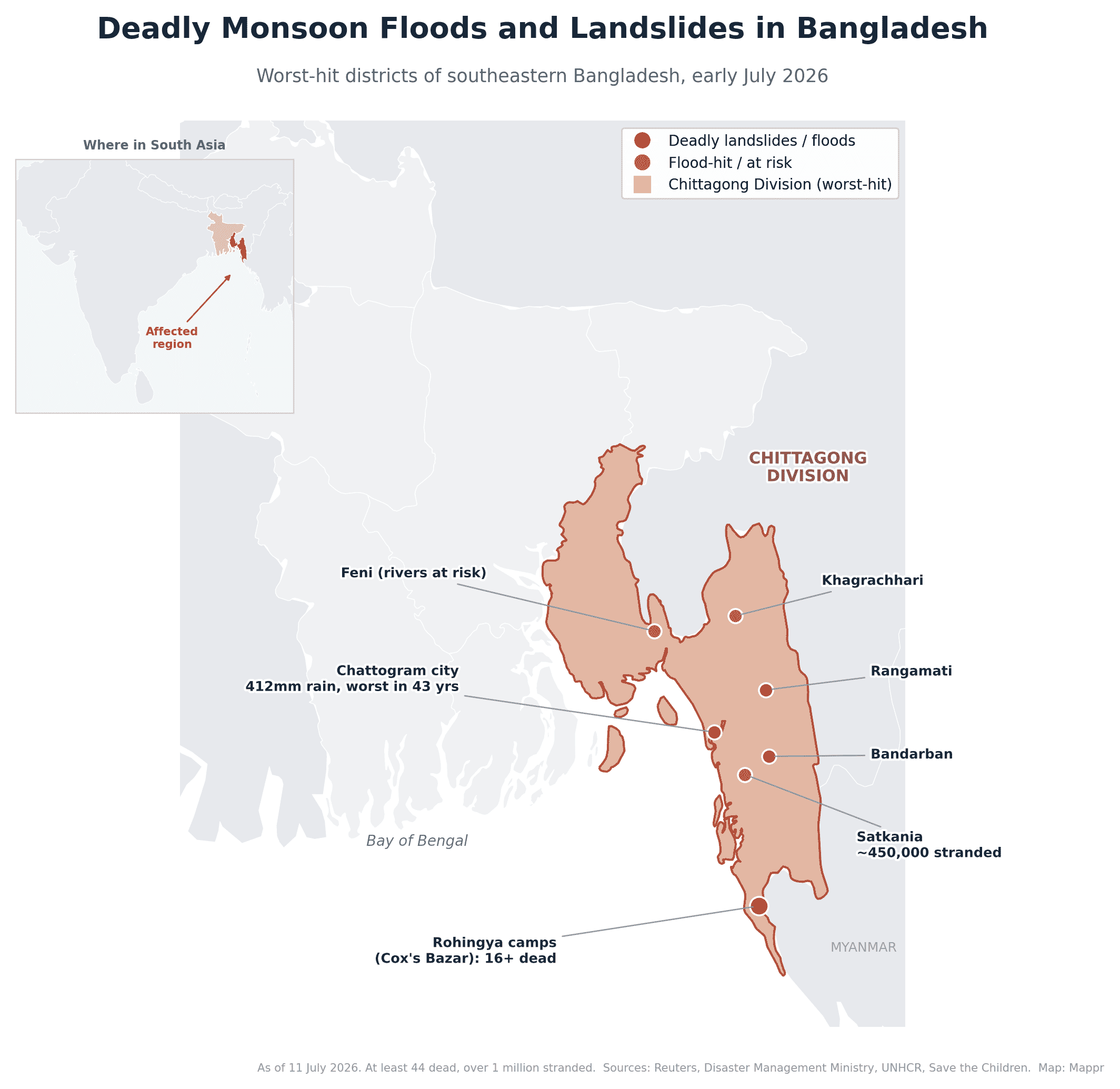
On 5 August the Teesta was running 13cm above its danger level at Dalia, putting chars, cropland and rural roads under water in Lalmonirhat. The map below shows where the worst damage has fallen.
The catastrophe is concentrated in the country’s Chattogram Division, the hilly, monsoon-battered southeast that wraps around the Bay of Bengal. It is a landscape uniquely exposed to this kind of disaster, and this year the rain has been extreme.
The scale of the disaster
Bangladesh’s Disaster Management Ministry lists seven flood-hit districts: Chattogram, Cox’s Bazar, Bandarban, Rangamati and Khagrachhari in the southeast, plus Moulvibazar and Habiganj in the northeastern Sylhet Division, where the flooding spread in the second week. In Chattogram district alone, some 450,000 people were left stranded across low-lying upazilas such as Satkania, as swollen rivers and hillside runoff combined. Nationwide, roughly 268,000 households have been cut off, many now reachable only by boat as the army and navy ferry in food, water and medicine.
By 15 July, the ministry’s toll stood at 57 dead: 32 in Cox’s Bazar (19 local residents and 13 Rohingya refugees), 15 in Chattogram, six in Bandarban, three in Rangamati and one in Moulvibazar, with 40 people injured. In the northeast, an embankment on the Khowai River collapsed under days of rain and upstream runoff, inundating at least 25 villages in Habiganj. Some 4,079 people were still staying in 111 official shelters.
On 16 July, the International Organization for Migration (IOM) said the emergency had in total touched 10 districts, counting host communities alongside the ministry’s seven flood-hit districts, with more than 38,400 people sheltering in over 1,000 evacuation centres. Among the affected are more than 52,000 Rohingya and over 13,000 people with disabilities. The agency announced it was scaling up emergency shelter assistance, relocations away from high-risk slopes, and mobile medical teams alongside government agencies.
On 29 July the Needs Assessment Working Group published its Joint Needs Assessment for Chattogram Division. It puts 1.28 million people affected across seven districts, 436,000 in need of humanitarian assistance, 59 deaths and about 33,500 people temporarily displaced.
The assessment counts more than 74,500 shelters damaged or destroyed, over 34,000 water points and 35,000 sanitation facilities hit, and more than 54,000 hectares of cropland affected, a wider crop figure than the 27,007 hectares logged for those districts a week earlier.
Food, safe drinking water, sanitation, healthcare and shelter repair rank as the most urgent needs. The NAWG also flags protection risks for women and children, including family separation, school disruption and heavier care burdens, alongside medicine and staff shortages at health facilities.
On 31 July the Gender in Humanitarian Action Working Group, convened by UN Women, published a Rapid Gender Analysis built on the same caseload: 1.28 million people affected and more than 436,000 needing assistance.
It finds women, girls and people with disabilities disproportionately affected, facing higher barriers to safety, essential services, aid and recovery while carrying heavier caregiving and household burdens. It calls for a gender-responsive, disability-inclusive and locally led response.
A Shelter Cluster field mission to Satkania, Banshkhali, Bandarban Sadar and Pekua, published on 30 July and released through ReliefWeb on 4 August, works from the same caseload and puts housing at the centre of it.
It finds the flimsiest homes took the worst of it: kancha houses of mud, bamboo and corrugated sheet, wrecked by prolonged flooding, erosion and landslides. Shelter repair is one of the most urgent needs, alongside longer-term investment in resilient housing and flood protection.
A record downpour on unstable hills
The trigger was extraordinary rainfall. On 7 July, the port city of Chattogram recorded 412mm of rain in 24 hours, its heaviest in 43 years, as a low-pressure system over the Bay of Bengal fed days of intense monsoon downpours over the region. Urban streets became rivers, and across the surrounding hills the saturated ground began to slide.
Southeastern Bangladesh is especially vulnerable because so many people live on or below steep slopes. When the hills are stripped of trees and the soil is soaked, gravity does the rest, and the results are deadliest where the housing is flimsiest.
Chattogram goes under again
On 17 August the city itself went back under. Continuous rain from first light flooded low-lying roads and alleys, and the Patenga meteorological office logged 167mm in the 24 hours to midday, 81mm of it between 6am and 9am, with the rain still falling.
Water stood knee-deep and deeper in Halishahar, Katalganj, Hamzarbagh, Muradpur, Bibirhat, Chawkbazar, Kapasgola, Reazuddin Bazar and Jamalkhan. Buses thinned out, rickshaw fares doubled, and water got into bookshops at Nupur Market.
The district administration told people living on the city’s landslide-prone slopes to move to safety, with very heavy rain still in the forecast. Local cautionary signal No. 3 stayed hoisted at Chattogram port.
The army’s 34 Engineer Construction Brigade says its river and canal drainage scheme is 98 percent finished and kept about 80 percent of the city dry, with the rest due by February. Four projects worth Tk 10,408 crore have been running for a decade.
The city caught a break the next morning. The Chattogram gauge logged just 17mm in the 24 hours to 9am on 18 August, against 138mm the day before, and 8mm more in the 24 hours to 9am on 19 August.
The break has held. Chattogram took 4mm in the 24 hours to 9am on 20 August, and the Karnaphuli at the city gauge, up 28cm on the tide, is still 2.78 metres under its danger mark.
The Daily Star put the 17 August fall higher than the port office did, at 189mm at Patenga in the 24 hours to 9am, including the same 81mm between 6am and 9am. Tidal surge, not rain alone, pushed the water into the streets.
Its account of the drainage work is harsher than the army’s. Four projects run by the development authority, the Water Development Board and the city corporation cost more than Tk 14,000 crore between them, and none has met its original deadline.
The canal renovation scheme, launched in 2017 and built by the army’s 34th Engineer Construction Brigade, has grown from Tk 5,616 crore to Tk 8,626 crore and has been suspended since late April at 95 percent complete.
The authority’s executive engineer says only 15 to 20 days of work remain on the key canals, delayed by untimely rain. The project director says finishing it would eventually cut the port city’s waterlogging by up to 75 percent.
A second piece of the defence is closer to done. The 9.5km Kalurghat-Chaktai Marine Drive, an embankment-cum-road on the western bank of the Karnaphuli costing Tk 2,275 crore, is 92 percent complete and due to open to all vehicles by December.
Twelve high-tide protection regulators and pump houses have already gone in at the canal mouths. The road will sit 24.5 feet above sea level, which is the point of it: the tides are what beat the drains on 17 August.
The rain has swung back to the coast. In the 24 hours to 9am on 3 September, Teknaf took 78mm and Cox’s Bazar 65mm, the two heaviest falls in the country, with 56mm at Chapainawabganj, 55mm at Satkhira and 50mm at Jaflong.
Teknaf has already logged 189.1mm in the first three days of September, well over half its full-month normal of 306.5mm, with Cox’s Bazar on 130mm against a normal of 403.1mm. Chittagong city, by contrast, has taken just 17mm.
The city’s own river is feeling it. The Karnaphuli at Chittagong rose 35cm on the tide to 0.74 metres, still 3.41 metres under its danger mark, while the Halda climbed 22cm at Narayan Hat and 20cm at Panchpukuria.
More is coming. The flood centre’s 3 September summary forecasts heavy to very heavy rain over Chattogram division within a day, and expects the Halda, Sangu, Matamuhuri and the other eastern rivers to rise rapidly before holding steady.
A midnight storm at Nazirartek
The wind did the damage further south. Around midnight on 17 August a squall hit the Nazirartek dry fish hub in Cox’s Bazar city, wrecking 15 to 20 production sheds and shops.
Fish on the drying racks and in the warehouses was blown away or soaked. Traders found churi shutki, loittya, faissya and popa scattered across the site the next morning, some of it carried nearly half a kilometre.
The cooperative society’s general secretary said rain had fallen intermittently all night before the wind arrived. Traders put the losses at around Tk 1 crore.
The local meteorological office recorded 114mm at Cox’s Bazar in the 24 hours to noon on 18 August, with gusts of 40 to 50km/h, and said the soaked ground had loosened around the drying structures before the squall hit.
Fishing trawlers along the Cox’s Bazar coast have been told not to go into deep sea until further notice.
The Rohingya camps: the human core of the tragedy
Nowhere is that more true than in the Rohingya refugee camps near Cox’s Bazar, home to roughly a million people who fled Myanmar and now live in the world’s largest refugee settlement. The camps are a dense maze of bamboo-framed, tarpaulin-covered shelters built on steep, deforested hillsides, and those slopes have been failing.
At least 17 people, most of them children, have been killed in and around the camps, according to Human Rights Watch and the International Rescue Committee. In the early hours of 6 July, three separate landslides tore through Camps 7, 11 and 15, killing eight people including five children, among them a family of a couple and their four-year-old son. Two days later, on 8 July, a hillside retaining wall collapsed onto a religious school in Ukhiya, killing eight more, seven of them students and one a teacher. Between 4 and 9 July alone, aid agencies logged 286 weather-related incidents in the camps, including 95 landslides, with more than 2,800 shelters damaged or destroyed; over 20,000 refugees have been relocated from the most dangerous ground. By 16 July, the UN migration agency IOM put the cumulative damage in the camps at more than 5,000 shelters.
The camps are still taking casualties. On 5 August a rain-triggered landslide killed a Rohingya child at Block F-5 of Camp 13 in Tajnimarkhola, Ukhiya, around midday, after a night of continuous rain loosened the hillside above the shelter.
The 8th Armed Police Battalion said its officers joined residents in the rescue and has told families on high-risk ground to move somewhere safer. Two more landslides blocked the Marine Drive road at Darianagar that morning until army teams cleared the debris.
The Cox’s Bazar meteorological office logged 121mm of rain in the 24 hours to noon on 5 August and expects the wet spell to run another three to four days.
The rain has parked on the coast. In the 24 hours to 9am on 14 August the Cox’s Bazar gauge logged another 122mm, the heaviest fall on the centre’s network for a second day running, after 147mm the morning before.
That is the ground the camps sit on. Cox’s Bazar has taken 647mm in the first half of August, past its 631mm August normal with half the month still to run. Teknaf, on 535mm against a normal of 488mm, is past its own.
Then it stopped. The Cox’s Bazar gauge logged nothing at all in the 24 hours to 9am on 15 August, and Teknaf 3.8mm, after 147mm and 122mm on the two previous mornings.
It stayed dry on 16 August, a second blank morning that held the Cox’s Bazar month total at 647mm. Teknaf took 35.5mm, the heaviest fall on the centre’s network, and moved to 570mm against a 488mm August normal.
Then the tap opened again. In the 24 hours to 9am on 17 August Teknaf logged 221mm, the heaviest fall anywhere on the network, with 70mm at Cox’s Bazar and 81mm at Lama.
That puts Teknaf on 791mm for August against a 488mm normal, and Cox’s Bazar on 717mm against 631mm, both past a full month’s rain with a fortnight still to run.
It has not let up. Teknaf logged another 240mm in the 24 hours to 9am on 18 August, the heaviest fall in the country for a second day, with 102mm at Cox’s Bazar and 81mm at Lama.
Teknaf is now on 1,031mm for August, more than double its 488mm monthly normal, and Cox’s Bazar on 819mm against 631mm, with 13 days of the month left.
Then the coast dried out. Teknaf took 1.5mm in the 24 hours to 9am on 20 August and Cox’s Bazar 2mm, leaving the month totals at 1,092.5mm and 912mm with 11 days to run.
September has been quieter on that coast, but not dry. Cox’s Bazar has logged 418mm for the month to 9am on 24 September, already past its 403.1mm September normal, with Teknaf on 295.1mm against 306.5mm.
The last three days barely registered there. The Cox’s Bazar gauge took 2mm, 2mm and 1mm on 22, 23 and 24 September, the lull the saturated slopes above the camps needed.
Aid cuts have made it worse
The disaster is colliding with a funding crisis. The 2026 humanitarian appeal for the Rohingya response is set at $710 million, about 26% lower than in 2025, and the World Food Programme faces a shortfall of roughly $147 million, having already moved to reduced, tiered food rations. UNHCR has warned bluntly that the funding cuts have heightened the monsoon risk, forcing reductions in the very slope-stabilisation and camp-maintenance work that keeps refugees safe. Save the Children ties the worsening conditions directly to donors scaling back.
The Norwegian Refugee Council puts the gap in sharper terms. It says the 2026 Joint Response Plan is short $45 million for emergency priorities alone, including $23.2 million for shelter and $9.1 million for water and sanitation.
Citing Rohingya Coordination Platform figures, the NRC counts about 52,800 refugees affected and 13,055 displaced, with close to 4,900 shelters partially damaged and 25 destroyed, alongside damage to water points, latrines and learning centres.
Its country director, Dipankar Datta, said that for thousands of Rohingya families the monsoon is no longer a normal period of the year but has become another life-threatening emergency.
Some money is moving the other way. On 27 July the IFRC published an operational update that nearly doubled its emergency allocation for the Bangladesh monsoon floods, from an initial CHF 475,000 to CHF 899,498.
The Bangladesh Red Crescent Society operation, first written for the Rohingya camps and host communities in Cox’s Bazar alone, now also covers Chattogram, Bandarban, Rangamati and Khagrachhari. Its target population rises from 80,000 to 125,000 people.
The extra funds buy multipurpose cash for 4,000 more households, cash for 500 people with specific needs, and replacement stocks of 5,500 dignity kits and 1,000 shelter toolkits. The operation now runs to 31 January 2027.
The same document puts the number of people affected at 1,116,174 and records that the flooding reached all 33 Rohingya refugee camps in Cox’s Bazar, damaging shelters, drainage, WASH facilities, access roads and retaining walls.
Smaller grants are landing too. On 30 July, 236 flood-affected families in Bandarban municipality received Tk 8,000 each, along with health protection supplies and safe drinking water.
World Vision Bangladesh and the local organisation GRAUS delivered the package with Start Fund money. MP Saching Prue Jerry handed it over at a Sadar Upazila Parishad function.
On 31 July the European Union announced €200,000 in humanitarian funding for people hit by the monsoon rains in Cox’s Bazar, Chattogram, Bandarban, Rangamati and Khagrachhari, its embassy in Dhaka said.
The money runs through the IFRC’s Disaster Response Emergency Fund to the Bangladesh Red Crescent Society, and is meant to reach 125,000 Rohingya refugees and vulnerable people in host communities.
It buys emergency shelter materials and shelter repairs, fixes to water and sanitation facilities, seeds and gardening supplies, and cash assistance. Women and girls at heightened protection risk get dignity items and referral support, and landslide protection is to be restored through cash-for-work.
Private money is moving too. BRAC Bank is putting Tk 2 crore into emergency assistance for 4,500 families hit by the southeastern flash floods, reaching more than 22,000 people in Khagrachhari, Bandarban, Rangamati, Chattogram and Cox’s Bazar.
Working through BRAC’s Emergency Response Team, it is giving each family a seven-day food package worth Tk 3,500 plus Tk 1,000 in cash.
Foreign money is arriving too. On 6 August the UAE Aid Agency announced urgent humanitarian supplies for people hit by the monsoon rains, delivered in coordination with Bangladeshi authorities.
Its chairman, Tareq Ahmed Al Ameri, cast it as part of the Emirates’ standing disaster-response commitment. The agency put no figure on the package.
A million farming households in need
The FAO put a national number on the farm damage on 27 August. Its Data in Emergencies monitoring round, built on 6,143 household interviews, estimates that about 1 million agricultural households, roughly 5 million people, need emergency agricultural assistance between June and November 2026.
That is 200,000 households more than the same exercise found in September 2025. The highest share of households in need is in Sylhet, Mymensingh and Rangpur, while Chattogram and Rangpur carry the largest absolute numbers.
The need clusters where the water goes: river systems, the haor basin and the flash-flood hotspots. Fifty-seven percent of those households farm less than a hectare and 60 percent sit in the least well-off third.
The coping is what it always is. Some 67 percent are buying food on credit, 66 percent have cut health spending and 30 percent have cut back on seed and fertiliser.
What the floods mean for women and girls
UNFPA’s situation report covering 8 July to 10 August counts 364,000 women of reproductive age among the 1.3 million people affected, including 17,490 pregnant women.
Damaged roads, flooded paths and landslides have cut remote communities off from clinics and hospitals. In the shelters, crowding, poor lighting and too few sex-segregated latrines compound the risk.
The response is running on a fraction of what it needs. UNFPA has mobilised $130,330 of a $966,930 requirement, leaving a gap of $836,600.
What it has delivered so far: 4,500 dignity kits, 1,951 menstrual health kits and 1,000 baby kits, with 6,326 people reached through gender-based violence risk mitigation and 1,018 women and girls seen at four health camps.
Receding, but not over
Floodwaters have begun to recede across Chattogram and the southeast, and rivers in Moulvibazar and Habiganj are slowly falling, but the recovery is fragile: rail services to Cox’s Bazar remained suspended, forecasters warned that low-lying areas along the Kushiyara and Surma rivers could see fresh flooding, and the threat of waterborne disease persists in the crowded camps.
That threat is no longer hypothetical: by 19 July, 206 diarrhoea patients were admitted across three Chattogram city hospitals and 14 upazila health complexes, around 30% of them children, and the health department had distributed 65,000 water purification tablets. The civil surgeon said the situation remained under control, with no confirmed diarrhoea deaths.
The respite may also be brief, and the flood threat is now shifting north. On the evening of 20 July, the Flood Forecasting and Warning Centre issued a special outlook warning that flash floods could hit at least 10 districts across the northern and northeastern regions within 24 to 48 hours, driven by very heavy rain inside Bangladesh and across the upstream Indian states of Assam, Meghalaya and West Bengal.
Two rivers are already above their danger marks: the Kushiyara is running 33cm over the danger level at Fenchuganj and 18cm over at Chhatak in Sylhet, while the Someshwari has breached its limit by 19cm at Kalmakanda in Netrokona, inundating low-lying areas.
Further north, the Teesta is at its warning level at four stations and, along with the Brahmaputra and Jamuna, is on a steady five-day rise that could cross danger marks within 24 to 72 hours, putting low-lying areas of Lalmonirhat, Kurigram, Gaibandha, Sirajganj and Tangail on alert. The FFWC’s Sardar Udoy Raihan flagged the flash-flood risk but said no major or prolonged flooding is expected at this stage.
By 22 July that northern threat had begun to bite. The Teesta rose to 52.14 metres at the Dalia point in Nilphamari, just 1cm below its 52.15-metre danger level, and floodwater pushed into low-lying parts of Lalmonirhat Sadar, Aditmari, Kaliganj, Hatibandha and Patgram, prompting authorities to open all the gates of the Teesta Barrage.
In Rangpur’s Gangachara upazila, two volunteer-built embankments on the Teesta breached, washing away about 150 metres of earthworks and leaving around 10,000 people stranded, with more than 100 homes at severe risk of erosion.
That northern crest proved short-lived: at the Dalia point the Teesta topped out just below its danger mark on the afternoon of 22 July and then fell steadily through the evening, easing to about 17cm below the danger level by 6pm and taking some of the immediate pressure off the floodplains, even as around 10,000 people in Gangachara stayed displaced.
By 23 July, this seventh wave of the monsoon had left more than 150 erosion points scarring the 242km Teesta basin, 20 of them in Rangpur, where some farmers reported losing close to 70 percent of their main crops.
The southeast is not clear either: in its 23 July situation report the UN inter-cluster group noted that the Bangladesh Meteorological Department was again forecasting heavy to very heavy rainfall over Bandarban, Chattogram and Cox’s Bazar, and had issued fresh moderate and low-risk landslide advisories for those districts.
The Bangladesh emergency is also part of a wider South Asian monsoon crisis: the same weeks have brought deadly flooding and landslides to India, Nepal and Pakistan, in what scientists describe as a pattern of longer dry spells broken by sudden, intense bursts of rain.
Upstream in Assam, whose runoff feeds the Brahmaputra and the flash-flood warnings issued inside Bangladesh, the season’s toll has risen to 105 dead, one further death in the state disaster authority’s 17 August bulletin.
The daily report counts nearly 32,000 people affected across 147 villages, down from about 52,000 on 16 August, and the district list has narrowed to four: Nagaon, Jorhat, Sivasagar and Golaghat.
Nagaon is still the worst-hit district, with about 20,000 people affected, followed by Jorhat at around 5,000 and Sivasagar at more than 4,500.
Some 15 relief camps and distribution centres are still running, between them helping 2,782 people.
The Dhansiri at Numaligarh is in what the authority calls a severe flood situation, with its level still rising and people told to stay away from the river.
The Kushiyara at Sribhumi, the border district that drains straight into Sylhet, is also over its danger mark.
The 17 August bulletin puts about 3,199 hectares of cropland under water, with embankments, roads and bridges damaged across the affected districts and more than 16,300 animals hit.
The next day’s bulletin barely moved. On 18 August the state toll held at 105 dead, with nearly 32,000 people still affected, spread across five districts rather than four, and about 3,000 people in relief camps.
The season’s full reach is far wider than the daily count. More than 1.2 million people across 25 districts and 2,734 villages have been hit at some stage this year, with 3,198 hectares of cropland still submerged.
The dead are concentrated in the upper valley. Sivasagar has lost 53 people and Charaideo 22, ahead of Jorhat with nine, Golaghat eight, Karbi Anglong four and Dhemaji three. Of the 105, seventeen were children.
Across India the monsoon has now killed more than 100 people since July, with Assam the worst-hit state, at least 31 dead in Jammu and Kashmir, 15 in Kerala and 14 from lightning strikes in Jharkhand.
What the attribution scientists found in Assam
On 14 August the World Weather Attribution group published its analysis of the Assam floods. It found no clear trend in the observed rainfall, and concluded that 1.4C of human-induced warming has not materially altered the likelihood or intensity of the 2026 downpours.
The rain itself had a return period of under two years, the study says. What turned it into a disaster was exposure: a sediment-choked Brahmaputra whose bed keeps rising, unplanned building, deforestation and drainage that no longer works.
Rigid embankments make it worse by blocking natural drainage, the authors argue. Their prescription is to work with the rivers rather than against them, pairing targeted engineering with floodplain restoration, wetland conservation and community preparedness.
The India Meteorological Department’s Guwahati centre now forecasts thunderstorms with lightning and moderate to heavy rain over Charaideo, Dibrugarh, Jorhat, Sivasagar and Tinsukia, several of them already under water.
That is the Brahmaputra valley, whose runoff arrives in Bangladesh as the Jamuna, and the same border catchments feed the flash-flood warnings inside Sylhet division.
By 25 July the picture had improved across the affected belt. In its district roundup that day, the state news agency BSS reported that floodwaters had receded in Habiganj with no families left stranded and just 6mm of rain in 24 hours; that Khagrachhari had logged no new landslides or hill collapses, with its rivers below danger level; that Cox’s Bazar had improved significantly, the Bakkhali at Ramu and the Matamuhuri at Chiringa both running well below danger level; and that Rangamati and Bandarban were back to normal, with displaced residents returning home from shelters. Chattogram remained the worst-hit district. Authorities have switched to loudspeaker awareness campaigns, warning people away from flood-damaged houses and live electrical wires and about snakebites and hygiene. In Moulvibazar the flash floods damaged crops on 57 hectares, around 405 fish ponds and some 54 rural roads built by the Local Government Engineering Department. On 26 July the Bangladesh Meteorological Department forecast only light to moderate rain and thundershowers nationwide, with the heaviest fall of the previous 24 hours a modest 36mm at Srimangal.
On 27 July the Flood Forecasting and Warning Centre said the flood situation in the low-lying areas along the Kushiyara in Sylhet district should improve over the next three days. The Surma and Kushiyara have both fallen and are expected to keep falling, though the Kushiyara was still running above its danger level at Fenchuganj.
The same bulletin had the Brahmaputra and Jamuna falling for another two days before steadying, the Ganges and Padma holding steady for five days, and the southeastern rivers (the Gomti, Muhuri, Feni, Selonia, Halda, Sangu and Matamuhuri) down off their peaks, with only a brief one-day rise expected.
The weather is not finished, though. Early on 27 July a monsoon depression over the northwest Bay of Bengal strengthened into a deep depression, and the Meteorological Department told the ports of Chattogram, Cox’s Bazar, Mongla and Payra to hoist cautionary signal No. 3.
The system was tracking north-northwest and was expected to cross the West Bengal and north Odisha coasts by that evening, with winds near its centre of about 50km/h gusting to 60km/h and rough seas. All fishing boats and trawlers were told to take shelter. Rainfall stayed modest: the heaviest 24-hour total to 6am on 27 July was 49mm at Teknaf.
By 28 July the rain had shifted rather than stopped. The Met Office forecast light to moderate rain or thundershowers with temporary gusty wind over the Dhaka, Mymensingh, Khulna, Barishal, Chattogram and Sylhet divisions, and warned that moderately heavy to heavy falls were possible at places across the country.
The heaviest 24-hour total to 6am on 28 July was 150mm at Hatiya, the island upazila in Noakhali, a sharp jump from the 36mm and 49mm national peaks of the two previous days.
On 29 July the Met Office widened the forecast again, predicting rain across all eight divisions in the 24 hours from 9am. Light to moderate rain or thundershowers with temporary gusty wind were likely at many places, with moderately heavy to heavy falls possible, and day and night temperatures expected to rise slightly.
On 31 July the Met Office issued a 120-hour bulletin that carries the wet spell into August. Rain and thundershowers are forecast at many places in Rangpur, Mymensingh, Dhaka, Barishal, Chattogram and Sylhet on 1 August, with a few places in Rajshahi and Khulna.
The spell broadens again by 3 August, with rain at most places in Rajshahi, Rangpur, Mymensingh and Sylhet, and moderately heavy falls likely in parts of the country on each of the three days.
The department said the monsoon remains active over Bangladesh, with the monsoon trough over the centre of the country and a depression over Vidarbha and adjoining south Madhya Pradesh moving west and weakening. It advised people in low-lying and flood-prone areas to stay alert to updated forecasts.
On 1 August the Met Office forecast light to moderate rain or thundershowers with temporary gusty wind across the country, with heavy falls likely at places in Rangpur, Mymensingh and Sylhet, putting the worst of the expected rain in the north and northeast rather than the flood-hit southeast.
The heaviest fall actually recorded in the 24 hours to that morning was still in the southeast, 59mm at Cox’s Bazar. Day and night temperatures were expected to hold steady, with a national high of 35.5°C at Nikli in Kishoreganj and a low of 23.9°C at Kumarkhali in Kushtia.
By 2 August the wet core had shifted decisively north. The Met Office forecast rain or thundershowers at many places over Rangpur, Rajshahi, Mymensingh and Sylhet, with moderately heavy to heavy falls possible there, and rain at only a few places over Chattogram, Dhaka, Khulna and Barishal.
The heaviest 24-hour fall to that morning was 87mm at Tetulia, in Panchagarh on the northern border, against 59mm at Cox’s Bazar a day earlier. The bulletin logged Saturday’s national high at 34.5°C in Dhaka and at Nikli, and the low at 23.8°C in Sylhet, with day temperatures expected to ease slightly.
On 3 August the Met Office forecast light to moderate rain or thundershowers with temporary gusty wind at many places over Rangpur, Mymensingh and Sylhet, and at a few places over Rajshahi, Dhaka, Khulna, Barishal and Chattogram.
Moderately heavy to heavy falls remain possible in those three northern divisions. The heaviest 24-hour fall to 6am that day was 81mm at Kutubdia in Cox’s Bazar district, ahead of anything recorded in the north.
Sunday’s national high was 35°C at Rangpur and the low that morning 24.4°C, recorded at both Sylhet and Bandarban. Day and night temperatures were expected to hold near steady across the country.
On 4 August the Met Office widened the rain again, forecasting light to moderate rain or thundershowers with temporary gusty wind at many places over Rangpur, Mymensingh, Dhaka, Barishal, Chattogram and Sylhet, and at a few places over Rajshahi and Khulna.
Moderately heavy to heavy falls were possible anywhere in the country. The heaviest 24-hour total to that morning was 80mm at M. Court in the Chattogram division, and day and night temperatures were expected to fall moderately.
Monday’s national high was 35.2°C at Jashore, with a low of 23.2°C at Narayanganj the following morning.
On 6 August the Met Office forecast light to moderate rain or thundershowers with temporary gusty wind at most places over Dhaka, Khulna, Barishal, Chattogram and Sylhet, and at many places over Rajshahi, Rangpur and Mymensingh.
Moderately heavy to very heavy falls were possible anywhere in the country. The heaviest 24-hour total to that morning was 198mm at Hatiya in Noakhali, against 94mm at Srimangal a day earlier.
The department also issued a 24-hour heavy-rain warning for four divisions from 9am that day, together with a landslide alert for Chattogram, the first such advisory for the hill district since the flood front moved north.
Wednesday’s national high was 32.5°C at Koyra in Khulna, with a low of 23.3°C at Narayanganj on Thursday morning. Day and night temperatures were expected to hold near steady.
On 7 August the Met Office kept rain over most of Dhaka, Mymensingh, Khulna, Barishal, Chattogram and Sylhet, and many places in Rajshahi and Rangpur, until 6pm, with moderate to very heavy falls possible at isolated spots.
It also flagged squally winds of 45 to 60km/h over Faridpur, Barishal, Patuakhali, Noakhali, Cumilla, Chattogram and Cox’s Bazar, and told river ports there to hoist local warning signal No. 1. Dhaka took 41mm of rain in the 24 hours to 6am.
What August is expected to bring
The Met Office’s monthly outlook for August points to near-normal rainfall nationwide after a very wet July, but with day and night temperatures above normal and one or two isolated mild to moderate heatwaves possible.
It expects one or two low-pressure systems to form over the Bay of Bengal during the month, one of them likely to deepen into a depression, and warns that heavy seasonal rain could still bring short-term flooding to the northern, northeastern and southeastern regions.
July itself came in 35.6 percent wetter than normal: an average of 666mm against a normal 457mm, spread over 25 rainy days rather than the usual 21. Three low-pressure systems formed over the Bay that month and two of them strengthened into depressions.
The Flood Forecasting and Warning Centre’s latest outlook puts the immediate flood risk in the north rather than the southeast. It flags Lalmonirhat, Nilphamari, Rangpur, Kurigram and Gaibandha on the Teesta and Dudhkumar, where levels could reach or cross danger marks within 72 hours.
It also lists low-lying ground along the Surma and Kushiyara in Sylhet and Sunamganj, the Dharla in Lalmonirhat and Kurigram, and the Someshwari, Bhugai and Kangsha in Sherpur, Mymensingh and Netrokona as at risk of temporary inundation.
Later on 3 August the centre widened that warning. It now sees a rising flood risk across northern, northeastern and southeastern districts, as heavy to very heavy rain inside Bangladesh meets intense rainfall in the upstream Indian catchments.
Districts along the Teesta, Dharla, Dudhkumar, Brahmaputra-Jamuna, Surma-Kushiyara and Feni river systems could see levels climb further if the rain holds. Flash flooding is the sharpest concern in Sunamganj and Netrokona, where low ground can go under within hours.
The centre’s own gauges put the heaviest 24-hour falls at 162mm at Dalia in Nilphamari, 150mm at Durgapur in Netrokona, 134mm at Maheshkhola in Sunamganj and 102mm at Noakhali. The FFWC said it is monitoring rainfall and river levels and will issue updated warnings as conditions change.
Ten districts on short-term flood warning
On the afternoon of 5 August the centre put a number on it: at least 10 districts at risk of short-term flooding within 24 to 48 hours, after heavy rain inside Bangladesh and torrential rain upstream in India.
Dirai in Sunamganj took 402mm in 24 hours, the country’s heaviest single-day fall of the year, while Cooch Behar in West Bengal recorded 254mm. Two stations were already over their danger marks: the Teesta at Dalia and the Kushiyara at Fenchuganj.
The risk splits three ways. Sylhet and Sunamganj sit in the immediate line on the Surma-Kushiyara; Lalmonirhat, Nilphamari, Rangpur, Kurigram and Gaibandha on the Teesta and Dudhkumar; and low ground in Sherpur, Mymensingh and Netrokona on the Bhugai-Kangsha and Someshwari.
FFWC executive engineer Sarder Udoy Raihan said the extreme rainfall of the previous 24 hours put those districts at risk within a day, but expects the flooding to ease over the following 72 hours.
The Water Development Board repeated the warning on 6 August, saying rising Surma and Kushiyara levels could inundate riverside areas in Sylhet and Sunamganj within two days, with the Met Office forecasting rain across all eight divisions for another five.
The FFWC’s own bulletin that morning put the Teesta 13cm above danger level at Tarapur in Gaibandha and the Kushiyara 11cm above at Fenchuganj in Sylhet. The Surma held steady while the Kushiyara kept rising.
The Teesta, Dharla and Dudhkumar in Rangpur all rose but were expected to recede over the following two days, and the Teesta flooding in Gaibandha to ease within a day.
The next worry is the Brahmaputra and Jamuna, both rising and forecast to keep rising for three days, which could put parts of Kurigram, Gaibandha, Jamalpur and Bogura at warning level. Upstream, Aizawl in Mizoram recorded 68mm of rain in 24 hours.
The Teesta crosses its danger level again
That warning turned into water within two days. At 6am on 5 August the Teesta was flowing at 52.28 metres at the Dalia point of the Teesta Barrage in Nilphamari, 13cm above its 52.15-metre danger level, after upstream hill runoff and days of heavy rain.
Char land, cropland and rural roads along the river have gone under in Lalmonirhat, leaving boats and makeshift rafts as the only transport in several localities. Water has entered homes in the Dawabari and Sindurna char areas, and riverbank erosion has started again.
Sunil Kumar, the Water Development Board’s executive engineer in Lalmonirhat, said the board is watching the river around the clock and has told residents of vulnerable areas to be ready to move to safer ground.
By 3pm the same day the Teesta had eased to 52.21 metres at Dalia, still over the 52.15-metre danger line, while the Dharla was running 1.39 metres below its own danger level at Shimulbari. Residents said few seasonal crops are in the ground right now, which should limit the farm losses.
The river then dropped back under the danger mark later on 5 August. The retreating water exposed severe riverbank erosion, damaged cropland and left cracks and collapses along the embankments.
It came back on the night of 6 August. Floodwater tore away roughly 20 feet of the paved road from Srishtiyarpar to Angarpota in Dahagram union of Patgram upazila, leaving a hole about 10 feet deep.
Around 10 localities in the union went under, affecting nearly 3,000 families, with about 2,000 families across five neighbourhoods in wards 2 and 3 cut off entirely.
Some 500 acres of Aman paddy were submerged, though the agriculture office reported no major loss because the water drained within hours. The Roads and Highways Department says repairs are under way.
The front moves to the Brahmaputra and the Atrai
By 7 August the northern crest was already easing. The FFWC bulletin that day had the Teesta down to 8cm above danger level at Tarapur in Gaibandha, while the Kushiyara climbed to 16cm above at Fenchuganj. Water was rising at 84 of the 127 monitored stations.
The rain had moved with it. Maheshkhola in Sunamganj took the national high of 138mm in the 24 hours to that morning, ahead of 107mm at Durgapur in Netrokona, 94mm at Patuakhali, 91mm at Barguna and 75mm at Pabna.
By the 8 August bulletin the Teesta had dropped under its danger mark too, leaving Fenchuganj the only station in the country still over the line.
The pressure has shifted west instead. The Brahmaputra and Jamuna rose again over the past 24 hours and could touch warning level within a day at points in Kurigram, Gaibandha, Jamalpur, Bogura, Sirajganj and Tangail, briefly flooding riverside low ground.
The Atrai is rising too, and may reach warning level at points in Naogaon and Natore, two districts that had stayed clear of this emergency until now.
By the 9 August bulletin that warning had hardened into a district list. The FFWC names eight districts at risk of short-term flooding: Kurigram, Gaibandha, Jamalpur, Bogura, Sirajganj and Tangail on the Brahmaputra-Jamuna, and Naogaon and Natore on the Atrai.
The Brahmaputra and Jamuna are forecast to rise for one more day before levelling off. The Atrai may cross its warning level in Naogaon and Natore within 24 hours, flooding riverside low ground.
The northern rivers have eased. The Teesta, Dharla and Dudhkumar are falling for now, though the FFWC expects them to rise again, and the Gomti, Muhuri, Selonia and Feni in the southeast have come down off their peaks.
Rainfall itself eased sharply. The heaviest 24-hour fall to the morning of 8 August was just 60mm at Teknaf, with 40mm at Maheshkhola. Upstream, Tezpur in Assam logged 59mm and Cherrapunji in Meghalaya 40mm.
The respite looked short at the time. The Met Office expects a fresh low-pressure area to form over Gangetic West Bengal and the adjoining northwest Bay of Bengal within 12 hours, keeping rain going for days and strengthening it again after five.
By 9 August the low was sitting over the southwest Bay of Bengal and the adjoining north Odisha coast, with the monsoon trough stretching from Rajasthan to Assam. The Met Office now expects only light to moderate rain for another three to four days.
Meteorologist Abul Kalam Mallik said the rain should pick up again on 12 or 13 August, with heavy to very heavy falls across the country from 15 August lasting several days.
The lull is already showing in the gauges. Dhaka recorded just 1mm in the 24 hours to 6pm on 8 August, against a national high of 74mm at Bhola, with the day’s top temperature 35.5°C at Mymensingh.
The FFWC expects moderate to heavy rain, very heavy in places, over the Sylhet, Chattogram and Rangpur divisions and their upstream catchments for the next two days.
The Met Office bulletin for 8 August put light to moderate rain or thundershowers with temporary gusty wind at many places over Rangpur, Mymensingh, Chattogram and Sylhet, and at a few places over Rajshahi, Dhaka, Khulna and Barishal, with moderately heavy to heavy falls possible.
On 10 August the forecast came back almost unchanged: rain or thundershowers with temporary gusty wind at many places over the same four divisions, at a few places over the other four, and moderately heavy to heavy falls possible anywhere.
The rain itself has swung back into the southeastern hills. The heaviest 24-hour fall to that morning was 100mm at Rangamati, one of the landslide-prone hill districts, against 74mm at Bhola two days earlier.
Day and night temperatures are expected to rise slightly. Sunday’s national high was 36°C at Rajshahi, with a low of 24.5°C at both Bandarban and Sylhet.
On 10 August the Flood Forecasting and Warning Centre widened its watch again, reporting rivers in the Teesta, Brahmaputra and Jamuna basins rising fast on upstream rain.
Low ground in Lalmonirhat, Nilphamari, Rangpur, Kurigram, Gaibandha, Jamalpur, Bogura, Sirajganj and Tangail went back on the short-term flood list, alongside Naogaon and Natore on the Atrai.
By 11 August that rise had turned. The Jamuna was falling at every gauge, by 16cm in 24 hours at Bahadurabad and 10cm at Sirajganj.
The Kushiyara at Fenchuganj stayed over the line throughout, at 9.67 metres that morning, 22cm above danger. It is absent from the centre’s observed water-level table and appears only in the 9am bulletin.
The Atrai threat faded with it. The river had dropped to 12.04 metres at Atrai in Naogaon, 121cm below its danger level, while the Teesta at Dalia sat 20cm under its own.
The Met Office’s 11 August bulletin kept rain over many places in Mymensingh, Khulna, Barishal, Chattogram and Sylhet, and a few places in Rangpur, Rajshahi and Dhaka, with moderately heavy to heavy falls possible anywhere.
The rain is thinning. The heaviest 24-hour fall to that morning was just 61mm at Gopalganj, against 100mm at Rangamati a day earlier. Monday’s national high was 36°C, at Sayedpur, Chandpur and Mymensingh, with a low of 23.2°C at Sylhet.
On 12 August the Met Office kept rain over many places in Khulna, Barishal and Chattogram, and one or two places in Rangpur, Rajshahi, Dhaka, Mymensingh and Sylhet, with moderately heavy falls possible.
On its own network the heaviest 24-hour total was 37mm at Chattogram. Tuesday’s national high was 36.4°C at Rajarhat and the low 24.3°C at Sylhet, with night temperatures expected to ease slightly.
On 15 August the Met Office narrowed it right down: light to moderate rain or thundershowers with temporary gusty wind at only a few places across all eight divisions, with moderately heavy falls still possible.
The heaviest 24-hour total on its network was just 15mm at Gopalganj. The national high on 14 August was 36.7°C at Dinajpur, with a low of 24.4°C at Bandarban, and temperatures were expected to ease slightly.
On 16 August it widened again: light to moderate rain or thundershowers with temporary gusty wind at many places over Dhaka, Mymensingh, Khulna, Barishal, Chattogram and Sylhet, and a few places over Rangpur and Rajshahi.
Moderately heavy to heavy falls are possible at places. The heaviest 24-hour total was 40mm at Sandwip, the national high 35.8°C at Sayedpur on 15 August, and day and night temperatures are expected to fall by one to two degrees.
The Khowai crosses in Habiganj
By 12 August the emergency had swung to the northeast. The Khowai, which drains out of Tripura into Habiganj, rose 173cm in 24 hours at Ballah to 21.40 metres, 20cm above its danger level.
It is one of only two stations over the line in the Flood Forecasting and Warning Centre’s 9am bulletin, alongside the Kushiyara at Fenchuganj, which sits 23cm over at 9.68 metres.
Upstream Tripura is feeding it. Sabroom in South Tripura recorded 67mm of rain in 24 hours and the town of Khowai 64mm, while the heaviest falls on the centre’s own gauges were 62mm at Ramgarh in Chattogram and 48mm at Jaflong in Sylhet.
The centre expects the Khowai to hold steady for a day and then fall for two. The Manu and Dhalai, also rising, should climb for another day before levelling off.
The southeast is filling again too. The Gomti rose 110cm at Comilla and the Muhuri 80cm at Parshuram, with the Selonia, Feni, Halda and Sangu all up, though every one of them is still metres below its danger mark.
Across the network 54 stations were rising, 72 falling and one unchanged. The Teesta at Dalia and the Someswari at Kalmakanda are both back at warning level rather than danger level.
The crossing lasted a day. By the 13 August bulletin the Khowai at Ballah had fallen 30cm to 21.10 metres, back under its 21.20-metre danger line, and the centre expects it to keep falling for three days.
At the Habiganj gauge the river is still filling, up 55cm to 6.80 metres, though that is 2.25 metres below its own mark. In the upstream Indian catchments the only significant falls logged were in Meghalaya: 65mm at Mawkyrwat and 38mm at Cherrapunji.
Across the network 52 stations were rising, 74 falling and one unchanged. The Gomti rose 44cm at Comilla and 69cm at Debidwar and the Selonia 45cm at Suber Bazar, while the Muhuri fell 140cm at Parshuram and the Feni 164cm at Ramgarh.
The Khowai has kept dropping since. It fell 70cm on 14 August to 20.40 metres and another 50cm on 15 August to 19.90 metres, with the Habiganj gauge down 52cm to 5.18 metres.
By the 15 August bulletin only 26 of 127 stations were rising and 101 falling, the emptiest reading of the emergency to that point. The Gomti gave up 56cm at Comilla and the Feni 79cm at Shuvopur.
The rain that feeds these rivers has moved to the border hills. Jaflong took 46mm and Latu 36mm inside Sylhet, while upstream Aizawl in Mizoram logged 70mm, Mawkyrwat 67mm, Mawsynram 52mm and Sohra 50mm in Meghalaya.
It has stayed there, and thinned. On 16 August Jaflong logged 43mm and Lalakhal 42mm inside Sylhet, with Mawkyrwat in Meghalaya the only notable upstream fall at 68mm.
No station inside Bangladesh reached the centre’s notable-rainfall threshold that morning. The Khowai gave up another 10cm at Ballah, the Gomti 33cm at Comilla, the Muhuri 35cm at Horipur and the Selonia 24cm at Malipur.
The Khowai crosses again, and the embankment goes
It came back on 23 August, and much harder. The Khowai at Ballah reached 22.50 metres, 130cm above its 21.20-metre danger line, ending the week of empty bulletins that began on 16 August.
At about 10:45am that Sunday the river’s protection embankment at Kaliganj, in Laskarpur union of Habiganj Sadar, tore open at the point that failed on 9 July. Water drove through the gap into the villages behind it.
Sayedur Rahman, the Water Development Board’s executive engineer in Habiganj, said hill runoff from upstream had put the Khowai 130cm over its danger mark at Ballah, and that the repaired stretch gave way under it.
The district disaster management office gave a higher figure, putting the river 178cm over its danger level when the breach opened. The flood centre’s own 9am reading for 23 August was 130cm, and the two numbers have not been reconciled.
The repair was never finished. The government released Tk 88 lakh after the July collapse, but the work was still incomplete a month and a half later, and residents blame the delay for the second breach.
Homes, unpaved roads and farmland went under along the breach line. Locals fear low ground in Laskarpur and in Lamatashi union of Bahubal upazila will follow, leaving thousands more marooned.
The whip and MP for Habiganj-3, G K Gous, had inspected the repair work at Laskarpur that morning, alongside Deputy Commissioner G M Sarfaraz, Superintendent of Police Tarek Mahmud and the executive engineer.
The crest passed fast. By the 24 August bulletin the Khowai had dropped 118cm to 21.32 metres at Ballah, 12cm over the line, with the Habiganj gauge down 10cm to 7.20 metres.
It is the only one of the 127 monitored stations above danger level on 24 August, and Habiganj the only district on the list. The centre expects the Khowai to keep falling for three days.
By 25 August it was under again. The Ballah gauge fell a further 82cm to 20.50 metres, 70cm below the danger mark, and the Habiganj gauge dropped 110cm to 6.10 metres.
It kept going. On 26 August Ballah read 20.15 metres, another 35cm off and 105cm below the line, with the Habiganj gauge down 60cm to 5.50 metres.
The centre expects the Khowai, the Manu and the Dhalai to keep falling for three more days. All three are running below danger level.
The damage behind the breach is now being counted. Around 5,000 people were left waterlogged in Habiganj Sadar, some 4,000 of them in Laskarpur union, with three shelter centres opened and 10 tonnes of rice allocated.
The upazila’s own count is larger. Habiganj Sadar UNO Abdullah Abu Zaher put it at about 4,500 families across 22 villages, among them Dakshin and Uttar Charhamua, Kaliganj, Sughar, Adyapasha, Noabad, Hatirthan, Katiadi, Baidyer Bazar and Bangaon.
A third figure is in circulation. The state news agency’s report of the water minister’s visit gave 30 villages and 50,000 people, but those are the numbers local campaigners attach to the 9 July breach at the same spot, not to this one.
The Department of Agricultural Extension puts 125 hectares of standing Aush paddy under water, along with 95 hectares of transplanted Aman, 22 hectares of Aman seedbeds and 25 hectares of vegetables.
Of the Tk 88 lakh released for the repair, about Tk 30 lakh had been spent when the embankment gave way. The MP for Habiganj-3 inspected the work that morning and said he was dissatisfied with its quality.
Dhaka sent a minister after it. State Minister for Water Resources Farhad Hossain Azad inspected the Kaliganj breach on 25 August, saying he had come on the prime minister’s instruction to find a permanent solution.
The immediate repair will be made with geo-bags. Longer-term work to stop Habiganj town flooding is promised, but only once the monsoon is over. The deputy commissioner, local MPs and the Water Development Board’s executive engineer went with him.
As the waters pull back, the first official damage assessments are landing. In Chattogram district alone, the district administration counts 6,020 houses destroyed and 9,208 damaged, along with 405 educational institutions, some 1,592km of roads and 169 bridges and culverts; all evacuees have now returned home from the district’s 670 shelters, and the government has allocated 1,200 tonnes of rice for relief. The blow to farming is severe: the Department of Agricultural Extension says flooding submerged and damaged Aus paddy on 9,043 hectares and summer vegetables on a further 5,907 hectares in Chattogram, too late in the season to replant, and officials have proposed free seed for affected farmers ahead of Aman planting in October.
The agricultural toll is not confined to Chattogram. The Ministry of Agriculture’s Department of Agricultural Extension says the monsoon flooding has now damaged crops across 43 districts nationwide, on a total of 114,723 hectares, with 107,845 hectares (nearly 90 percent) concentrated in 16 districts. Nationally, an estimated 79,500 hectares of Aus rice, 10,504 hectares of Aman seedbeds and 17,800 hectares of seasonal vegetables have been damaged; in Cumilla district alone, crops on 19,899 hectares were affected.
On 27 July the ministry published what it describes as its final assessment of the 7 to 19 July rains. It counts more than 243,000 farmers hit across 43 districts, with roughly 134,000 tonnes of crops worth about Tk 478 crore damaged on 24,138 hectares, close to 3 percent of the 817,000 hectares under cultivation.
Of that damaged land, 12,783 hectares were Aus paddy, 1,746 hectares Aman seedbeds and around 9,000 hectares vegetables, alongside ginger, chilli, turmeric, papaya, jute, banana and sugarcane. The ministry’s final damaged-area figure is far lower than the interim count of 114,723 hectares reported earlier in July.
Rehabilitation money has been approved for seven worst-hit districts: Brahmanbaria, Habiganj, Chattogram, Cox’s Bazar, Rangamati, Bandarban and Khagrachhari. Some 63,000 farmers there have already been given late-variety Aman seed to replace lost Aus crops and seedbeds, with help for the rest promised before the winter cropping season.
In the north the next crop is going in more or less on schedule. The Department of Agricultural Extension said on 30 July that Aman seedlings had been transplanted on 267,267 hectares in the Rangpur region, 43 percent of a 621,550-hectare target.
That region covers Rangpur, Gaibandha, Kurigram, Lalmonirhat and Nilphamari, the districts squeezed by the Teesta’s July rise. Officials say late-variety seedbeds on highland and floating seedbeds in low-lying areas were readied in case August brings fresh flooding.
The repair bill for the roads
The Roads and Highways Department has put a price on its share of the damage. Its Summary of Flood Damage report, reported on 27 July, seeks Tk 378 crore to repair 213km of flood-damaged road across six road divisions in five southeastern districts.
That splits into Tk 45.87 crore for short-term repairs and Tk 332.37 crore for long-term rehabilitation. District highways account for 145.91km of the damaged network, against 34.09km of national highways and 32.95km of regional highways.
Chattogram South, covering Banshkhali, Satkania, Lohagara and Chandanaish, is worst hit at 73.08km, followed by Bandarban at 56.63km plus five bridges and a culvert, Chattogram at 52.77km, Cox’s Bazar at 15.34km, Khagrachhari at 11.73km and Rangamati at 3.39km. Emergency repairs have already started.
The prime minister goes to Chattogram
The government response is about to get its most visible outing. Prime Minister Tarique Rahman will visit three flood-hit Chattogram upazilas, Hathazari, Fatikchhari and Banshkhali, on 9 August.
He is due to distribute relief, hand over 100 newly built houses to families displaced by the floods, and address a public gathering in West Banshkhali. His press secretary says it is his first official trip to Chattogram since taking office.
By 8 August the preparations were done. The district administration has the houses finished and a helipad ready, with the prime minister due to arrive by helicopter in Banshkhali’s Baharchhara union before moving on to Fatikchhari and Hathazari.
He went on 9 August, leaving Tejgaon at 9:15am and landing at Matarbari in Maheshkhali around 11:30am, where he inspected the deep-sea port, the coal-fired power project and the Maheshkhali Integrated Development Authority.
He reached West Banshkhali, in Baharchhara union, at about 1:20pm and handed over the keys to 100 newly built houses for families whose homes were destroyed in July’s rain and hill runoff. He also distributed relief and planted a mahogany sapling.
Each house has two rooms and an attached toilet, built on RCC pillars with timber and corrugated iron sheet for disaster resilience, and paid for with government funding. The handover was part of a rehabilitation event on the Banshkhali High School and College ground.
He then stopped at madrasas in Fatikchhari and Hathazari before a rehabilitation programme at Hathazari Government College, where 30 flood-hit families were due Tk 100,000 each to rebuild and 15 people with disabilities Tk 10,000 each.
Travelling with him were Finance Minister Amir Khasru Mahmud Chowdhury, Home Minister Salahuddin Ahmed, Disaster Management and Relief Minister Asadul Habib Dulu and State Minister for Power and Energy Anindya Islam Amit. He flew back to Dhaka from Shah Amanat International Airport at 10:20pm.
Beyond the southeast: Bogura and Manikganj
The damage is not only southeastern. In Bogura, in the north, weeks of monsoon rain and upstream river flows have destroyed crops worth more than Tk 50 million on about 517 hectares, hitting close to 5,000 farmers, the Financial Express reported on 28 July.
Upstream water has inundated 16 unions across seven of the district’s 12 upazilas. The local weather office says this monsoon has already run 195.3mm wetter than last year, with 309mm falling in the first 10 days to 13 July.
Relief so far is Tk 500,000, an amount agriculture officials call insignificant against the scale of the loss. A full assessment is still being prepared, and officials warn of a summer vegetable shortage in the north unless seed, fertiliser and cash reach farmers quickly.
In Manikganj, in central Bangladesh, flash floods damaged crops on 222 hectares and hit 4,885 small and marginal farmers, the state news agency BSS reported on 29 July. The district took at least 301mm of rain between 4 and 10 July.
The Department of Agricultural Extension has filed a damage report and the local administration a second one. Agriculture Secretary Rafiqul I Mohamed said the government would decide promptly on assistance and incentives for flood-affected farmers nationwide, Manikganj included.
A UN inter-cluster situation report published on 23 July put firmer numbers on the damage. Across the seven worst-hit districts, 1.28 million people are affected, including more than 15,500 people with disabilities, and roughly 436,000 need humanitarian assistance. Government assessments count 74,479 houses damaged or destroyed, plus 29,076 water points and 36,550 latrines damaged across 42 upazilas in six districts, a water and sanitation failure that compounds the diarrhoea risk already showing up in Chattogram’s hospitals. Some 27,007 hectares of cropland in those districts were hit and more than 266,000 livestock affected, with combined livestock and fisheries losses put at $17.3 million.
A separate post-flood assessment by the Department of Livestock Services, reported on 24 July, sets the animal toll in the Chattogram region at Tk 771.5 million (Tk 77.15 crore). It counts 161,394 animals killed, among them 158,600 chickens, 2,508 ducks, 165 goats, 71 cattle and 50 sheep, across 191 unions in 45 upazilas of five districts. Some 10,991 farms were affected, 4,756 of them livestock farms and 6,235 poultry farms, and a further 223,390 cattle, 4,755 buffaloes, 160,087 sheep, 2.85 million chickens and 70,370 ducks fell sick and are being treated. Chattogram district alone accounts for Tk 600.68 million of the losses, ahead of Cox’s Bazar at Tk 135.39 million, Rangamati at Tk 29.98 million, Khagrachhari at Tk 3.7 million and Bandarban at Tk 1.75 million. Lost animal feed, 910 tonnes of concentrate, 14,265 tonnes of straw and 9,129 tonnes of grass, is valued at close to Tk 350 million.
The view from Banshkhali
On 28 July the Guardian set Bangladesh’s floods alongside a band of extreme rainfall running from Afghanistan to Taiwan, reporting from Banshkhali, one of the Chattogram upazilas swept by the early-July flash flood.
Jesmin Akter carried her six children through chest-deep water to her mother’s house and stayed there for more than a week. Her poultry died, her paddy field flooded and the house the family had repaired months earlier collapsed.
They are back in the ruins now, sleeping on plastic sheets and living on aid, with one daughter already running a fever. In eastern Afghanistan the same run of storms killed at least 31 people last week and left hundreds missing.
The bottom line
This is a disaster of geography and circumstance combined: record rain falling on cleared hillsides where a million of the world’s most vulnerable people have nowhere safer to go, at the exact moment the money to protect them is being cut.
The monsoon has months left to run. The seven-day stretch with no station in the country above its danger level ended on 23 August, when the Khowai went 130cm over at Ballah.
On 26 August none of the 127 is over the line for a second day, with 47 rising against 77 falling and three steady.
The watch has not lifted, but the upstream rain has. The Meghalaya burst of 25 August, 175mm at Mawkyrwat and 132mm at Cherrapunji, was down to 57mm at Cherrapunji in the 24 hours to 9am on 26 August, with 62mm at Siliguri the only other station listed.
The low that formed over the northwest Bay on 23 August has kept moving away. By 26 August it had tracked northwest from Jharkhand to northeast Madhya Pradesh, with the monsoon trough running from Gangetic West Bengal to Assam across southern Bangladesh.
The monsoon is rated fairly active over Bangladesh and moderate over the North Bay. Moderate to moderately heavy rain is still forecast over Sylhet, Mymensingh, Rangpur and Chattogram for another three days, heavier upstream.
The Met Office’s 26 August bulletin repeats it: rain at many places over Rangpur, Mymensingh, Barishal, Chattogram and Sylhet and a few places over Rajshahi, Dhaka and Khulna, with moderately heavy falls possible.
The tail of its five-day outlook is heavier. From 29 August it puts rain across all eight divisions with moderately heavy to heavy falls at places, and says rainfall activity should continue beyond that.
Its own network has eased further: the heaviest fall of the previous 24 hours was 31mm at Sylhet. Tuesday’s national high was 35.7C at Chuadanga and Wednesday morning’s low 24.2C at Sylhet, with temperatures expected to slip.
The Khowai at Ballah is further under its danger mark, by 105cm on 26 August. Behind it the Kushiyara sits 34cm under at Fenchuganj and 45cm under at Markuli, with the Teesta at Dalia 52cm under.
The coastal rivers of Barishal, Khulna and Chattogram are still off a normal tide. On 26 August the centre again reports a higher than normal tide on the Kirtonkhola, Lower Meghna, Pashur, Ichamati, Karnaphuli, Little Feni and Noakhali Khal, and again expects it to hold two more days.
Data and references (as of 8 October 2026):
Image Sources