
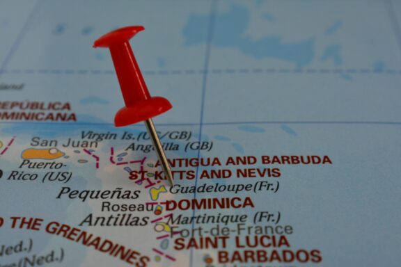
With a name that translates to “Ancient and Bearded” in English, there’s certainly some mystery surrounding this beautiful island country. Where is Antigua and Barbuda?
Antigua and Barbuda is located in the Caribbean and is part of the North American continent.
Antigua and Barbuda Interesting Facts
- Antigua and Barbuda is the 14th smallest country in the world.
- The country is famous for having 365 different beaches — one for every day of the year.
- It’s home to the largest Frigate Bird colony in the western hemisphere.
Precise Location Coordinates of Antigua and Barbuda
The DMS (Degrees, Minutes, Seconds) coordinates for the center of Antigua and Barbuda are:
- 17° 3′ 38.94” N
- 61° 47′ 47.14” W
The latitude and longitude of Antigua and Barbuda are:
- Latitude: 17.060816
- Longitude: -61.796428
You can see the location of Antigua and Barbuda on the world map below:
Neighboring Countries and Maritime Borders of Antigua and Barbuda
As an island country in the West Indies, Antigua and Barbuda doesn’t share any foreign land borders. The closest foreign nations are the British Overseas Territory of Montserrat and the Caribbean nation of St. Kitts and Nevis.
Antigua and Barbuda has direct access to both the Caribbean Sea and the Atlantic Ocean.
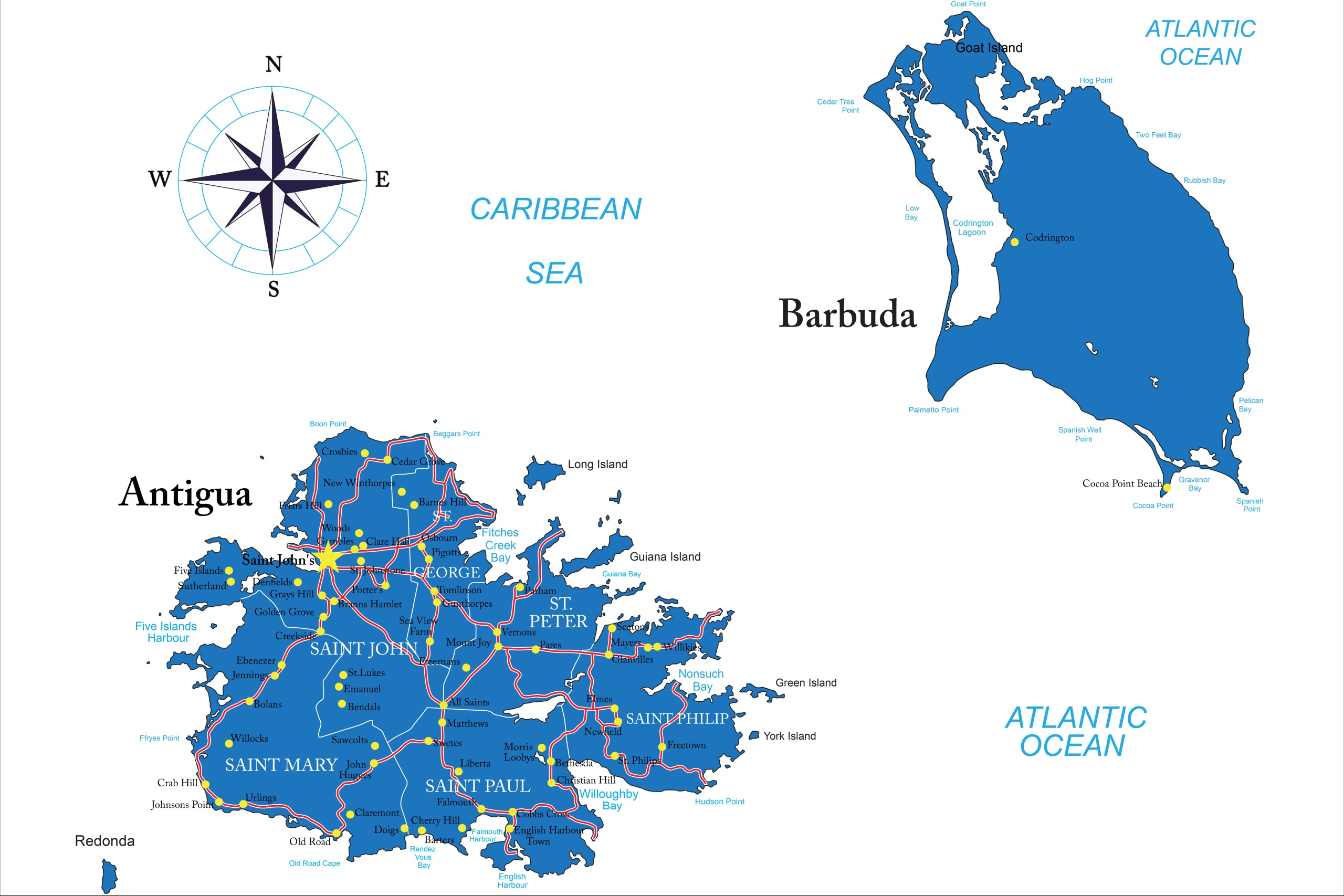
Administrative Divisions of Antigua and Barbuda
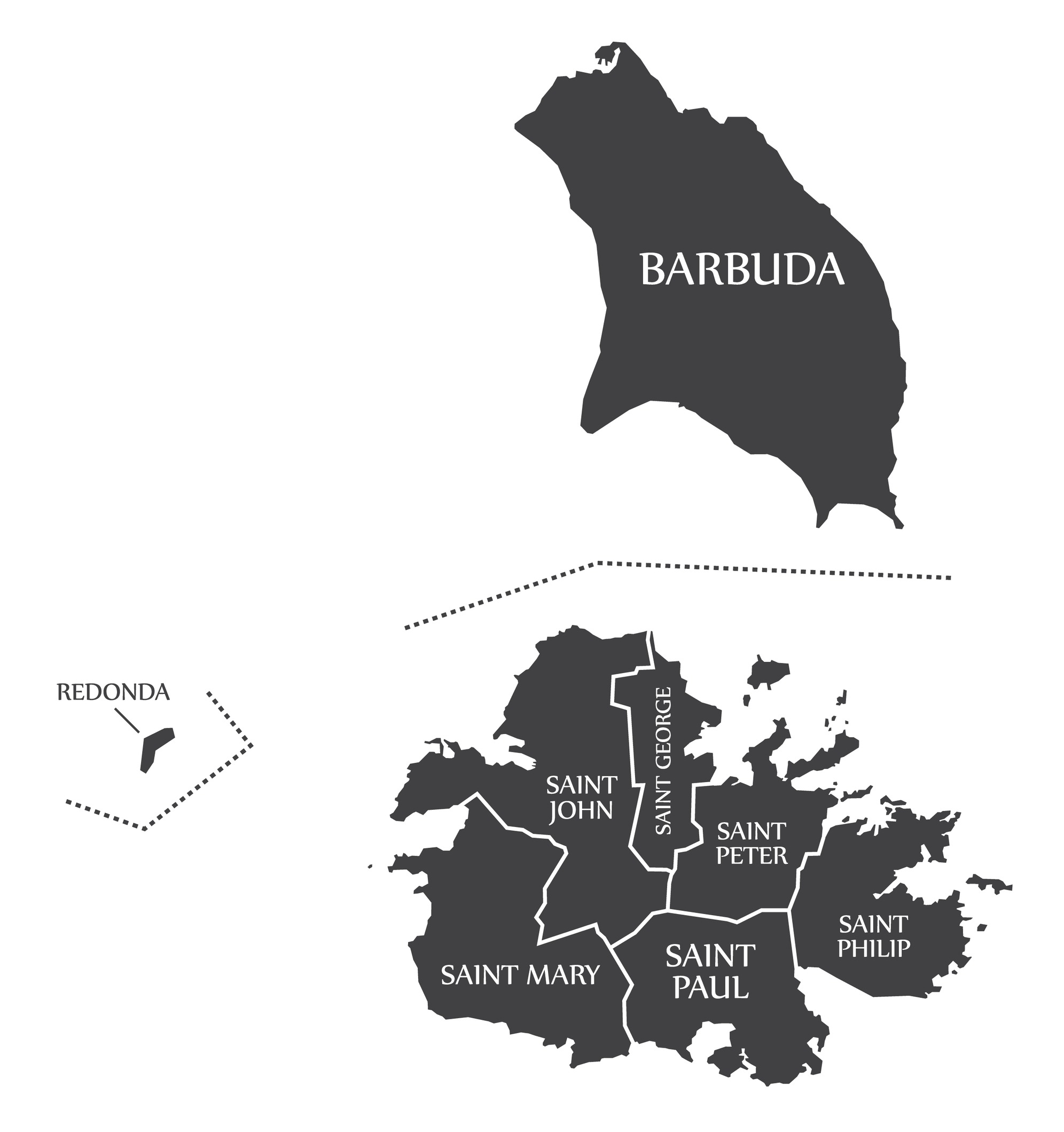
Antigua and Barbuda can be divided into six parishes and two dependencies. All of the country’s parishes are located on the island of Antigua, where about 97% of the population resides. The two dependencies consist of the islands of Barbuda and Redonda, but they are essentially treated as parishes.
The most populous parish in Antigua and Barbuda is St. John, which is where the country’s capital is located. It is also the largest parish on the island of Antigua. The largest administrative division in size is the dependency of Barbuda, which covers 160.6 km2 (62 mi2).
Geography of Antigua and Barbuda

The islands of Antigua and Barbuda contain a total land area of 443 km2 (171 mi2); Antigua is the largest island, followed by Barbuda. The island of Redonda is significantly smaller and uninhabited, covering just 1.6 km2 (0.6 mi2).
The country’s islands consist primarily of limestone formations, which accounts for their relatively low elevations. The highest points in the country formed through volcanic activity, such as Boggy Peak, known as Mount Obama from 2008 to 2016. Boggy Peak includes the tallest point in Antigua and Barbuda at 402 meters (1,319 feet).
In addition to the two main islands of Antigua and Barbuda, there are a number of smaller, uninhabited islands located just off their shores. All of the islands have irregular coastlines and are surrounded by reefs. Many beaches, lagoons, and natural harbors can be found throughout the country.
Due to its location in the middle of the ocean and a lack of precipitation, there is insufficient fresh groundwater on the islands for the local population. This problem is exacerbated by the clearing of trees for expanded crop production, which causes excess water runoff.
History of Antigua and Barbuda
The earliest settlements in Antigua and Barbuda were established by the Ciboney people between 3100 and 2830 BCE according to radiocarbon dating. The next people to inhabit the island were the Arawak-speaking Saladoid people, who brought agriculture to the islands, growing corn, sweet potatoes, and the famous Antigua black pineapple.
The Caribs would settle on the islands later, possibly by force, and Christopher Columbus was the first European to come upon the island in 1493. The Spanish did not colonize the island immediately, but the introduction of European and African diseases combined with malnutrition and the slave trade’s exploitation of the islands led to the near-disappearance of the native population.
After Spanish and French attempts at colonizing the islands had been unsuccessful, a British settlement was established in Antigua in 1632. It officially became a British colony in 1667. The British used the land to grow tobacco and sugar, importing a large number of slaves from West Africa.
The working and living conditions imposed on slaves were especially brutal, and this led to several violent revolts in the 18th century. Slavery was abolished in the British Empire in 1834, but former slaves had little economic opportunities and many continued to work on plantations for minimal pay.
Antigua and Barbuda’s political status changed multiple times in the 20th century. It joined the West Indies Federation from 1958 to 1962 and then became an associated state of the United Kingdom with full internal autonomy in 1967. The country finally gained full independence in 1981, opting to remain a member of the Commonwealth.
Vere Bird was the first prime minister of independent Antigua and Barbuda in 1981, and his son Lester Bird would be elected to the position in 1994. The Bird family would remain in power until 2004.
In 2017, Hurricane Irma caused major damage to the island of Barbuda. It destroyed 90% of the island’s buildings, and all inhabitants were eventually evacuated to Antigua. Efforts to rebuild the island were estimated to be around $100 million.
People and Culture of Antigua and Barbuda
The total population of Antigua and Barbuda is around 94,000 and is predicted to begin to decline within the next two decades. The vast majority of the population lives on the island of Antigua, and an increasing number of the country’s citizens are living abroad in countries like the UK, USA, and Canada.
Ethnicity
The largest ethnic groups in Antigua and Barbuda are West African, British, and Madeiran. 91% of the population is Black, 4.4% is of mixed race, 2.9% identifies as other, and %1.7 is White.
Almost 70% of the country’s population was born in Antigua and Barbuda, and immigrants living in the country are primarily from Dominica, Guyana, Jamaica, and the Dominican Republic, among others.
Religion
The predominant religion in Antigua and Barbuda is Protestantism, which is practiced by about 68% of the country. Roman Catholics make up just over 8% of the population, and almost 6% declared no religion. There are also small groups of Rastafarians, Muslims, and Hindus.
The constitution of Antigua and Barbuda guarantees religious freedom to its citizens.
Language
The official language in Antigua and Barbuda is English, although Antiguan creole is also spoken on the island. The use of Antiguan creole is looked down upon by part of the population and its use is discouraged in education, favoring Standard British English instead.
Although they’re part of the same country, the accents on Antigua and Barbuda are quite different from each other.
Cuisine
The food in Antigua and Barbuda includes dishes that are indigenous to the islands as well as those borrowed from other Caribbean islands. Common foods are saltfish, a variety of meats and vegetables, and beverages like mauby and tamarind juice. The Antiguan black pineapple is a special variety of pineapple cultivated on the island.
The national dish of Antigua and Barbuda is fungie and pepperpot. Fungie, called cou-cou on other Caribbean islands, is a mixture of cornmeal and okra similar to polenta. The pepperpot portion of the meal consists of a thick stew with vegetables and salted meat.
Arts
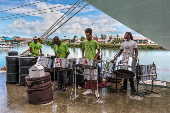
The culture of Antigua and Barbuda is uniquely influenced by the traditions of both West Africa and the United Kingdom. Musically, the biggest influences in the country are of African origin. Many of the genres that are popular throughout the Caribbean — calypso, reggae, soca, steel drum, zouk — are also popular in Antigua and Barbuda.
One of the most significant festivals in the country is the Antigua Carnival, which has been held in August every year since 1957 and celebrates the abolition of slavery in 1834. The festival lasts for two weeks and features dancing, parades, and parties.
There are a number of art galleries in Antigua, and craft traditions include the making of dolls, steel and wood scripture, pottery, painting, and other forms of art.
Biggest Cities in Antigua and Barbuda
Here are the largest cities in Antigua and Barbuda based on 2024 data:
| City | Population |
|---|
| Saint John's | 51,737 |
Map of Antigua and Barbuda with the Largest Cities
Antigua and Barbuda Economy Facts
| Country | Antigua and Barbuda |
| Coordinates | Latitude: 17.060816 Longitude: -61.796428 |
| Country Codes | Alpha 2: AG Alpha 3: ATG |
| Country Flag Emoji | 🇦🇬 |
| Int. Phone Prefix | +1-268 |
| Capital city | St. John's |
| Continent Subcontinent | North America Caribbean |
| Country Area | 443 sq km |
| Population 2025 | 94,209 World Rank: 195 |
| Median Age | 34.7 |
| Life expectancy | 77.8 |
| Major languages | English (official), Antiguan creole |
| UTC/GMT Time | Number of time zones: 1
|
| Internet TLD | .ag |
| Biggest Airport | V.C. Bird International Airport (ANU) |
| Average temperature | 25.85 °C 78.53 °F |
| Administrative Divisions | 6 parishes 2 dependencies |
| Political system | Parliamentary democracy |
Government and Politics in Antigua and Barbuda
The government of Antigua and Barbuda is a representative democratic monarchy. The present King of Antigua and Barbuda is Charles III, who took the throne after the death of his mother, Queen Elizabeth II, in 2022.
As the head of state, the monarch appoints the governor-general who represents the monarch in Antigua and Barbuda. The governor-general appoints the prime minister, who acts as the head of the government. Elections are held to elect members of the country’s House of Representatives.
Tourist Attractions of Antigua and Barbuda
The economy of the island nation is dominated by tourism, which is understandable considering the many reasons to visit Antigua and Barbuda. Luxury resorts attract wealthy foreign tourists (as does the country’s 0% personal income tax rate), and the low level of crime makes it an attractive Caribbean location for many. Read on to learn about some of the country’s best tourist attractions.
Stingray City

Located just a short speedboat ride from Antigua’s east coast, this shallow pool in the ocean is home to hundreds of stingrays. Taking a tour here will give you a chance to feed the friendly animals and even swim or snorkel with them if you’re comfortable enough.
The waters are crystal clear here, and the visibility is great. This is an excellent activity for families with children.
Nelson’s Dockyard

Nelson’s Dockyard is part of a UNESCO World Heritage Site in Antigua and Barbuda. It’s significant for being the location of the former 18th-century British Naval Dockyard and for being the only continuously operating Georgian-style dockyard in the world.
This site is located at the southern end of Antigua and offers tourists a wide range of amenities, such as hotels, museums, restaurants, and art galleries.
Valley Church Beach
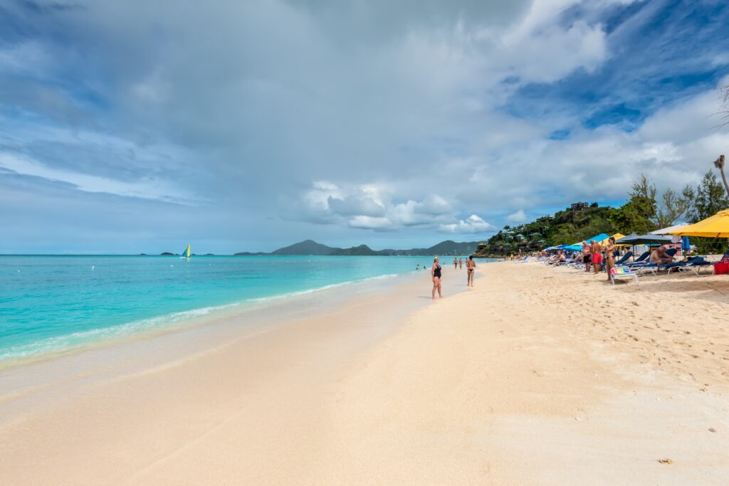
This is considered to be one of the best beaches in the country. It’s located on the island of Antigua, near Jolly Harbor, and features white sand and turquoise water. One of the reasons this beach is a favorite is the easy access to amenities like beachside restaurants and restrooms. It’s also easy to rent chairs and an umbrella for extended time relaxing next to the waves.
Transportation and Infrastructure of Antigua and Barbuda
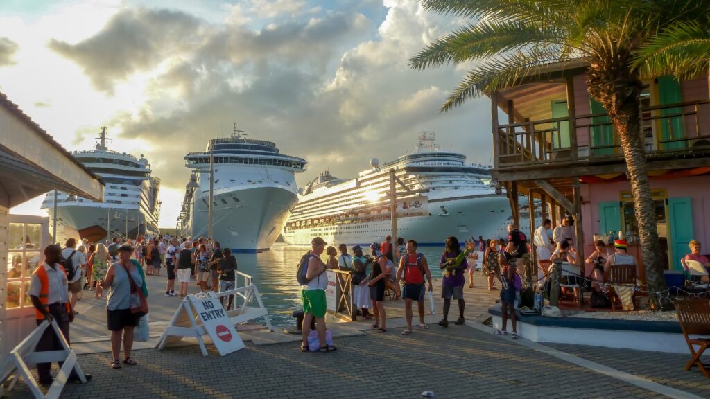
Since it is an island nation, the two ways of accessing Antigua and Barbuda are by plane and by boat. Direct international flights are available from the USA, Europe, and Canada, as well as other Caribbean islands. Flights arrive at the country’s V.C. Bird International Airport.
A number of ports around the islands offer access to larger boats, and it’s also possible to arrive via cruise ship.
Once in Antigua, the best way to get around the island is by rental car or taxi. A rental car may be a better value for longer stays, but taxi trips can be more convenient for a shorter time on the island. Bus services are available, but they can be unreliable.
Climate and Weather of Antigua and Barbuda
Antigua and Barbuda’s climate is hot, tropical, and humid all year long. Temperatures average 27 °C (80.6 °F), and the islands generally experience low levels of precipitation. The wettest months are between September and November, but droughts are common occurrences.
Hurricanes frequently affect the islands, striking an average of once a year. The island of Barbuda was struck by major hurricanes that caused great damage in 1995 and 2017.
Antigua and Barbuda Related Content
- Countries That Have Left-Hand Traffic
- Caribbean Islands Map with Countries, Sovereignty, and Capitals
- Antilles Map
Antigua and Barbuda Key Facts
| Country | Antigua and Barbuda |
| Coordinates | Latitude: 17.060816 Longitude: -61.796428 |
| Country Codes | Alpha 2: AG Alpha 3: ATG |
| Country Flag Emoji | 🇦🇬 |
| Int. Phone Prefix | +1-268 |
| Capital city | St. John's |
| Continent Subcontinent | North America Caribbean |
| Country Area | 443 sq km |
| Population 2025 | 94,209 World Rank: 195 |
| Median Age | 34.7 |
| Life expectancy | 77.8 |
| Major languages | English (official), Antiguan creole |
| UTC/GMT Time | Number of time zones: 1
|
| Internet TLD | .ag |
| Biggest Airport | V.C. Bird International Airport (ANU) |
| Average temperature | 25.85 °C 78.53 °F |
| Administrative Divisions | 6 parishes 2 dependencies |
| Political system | Parliamentary democracy |


