Back-to-back low-pressure systems struck Hawaii in March 2026, delivering some of the worst flooding the state has seen in more than two decades. The subtropical weather systems — called kona lows near Hawaii — siphoned moisture from the tropics, fueling slow-moving thunderstorms with torrential, destructive rains across the island chain.
NASA’s Earth Observatory has released satellite imagery showing the devastating impact on Oʻahu’s North Shore, where swamped neighborhoods and farmland between Mokuleia and Waialua are clearly visible from space.
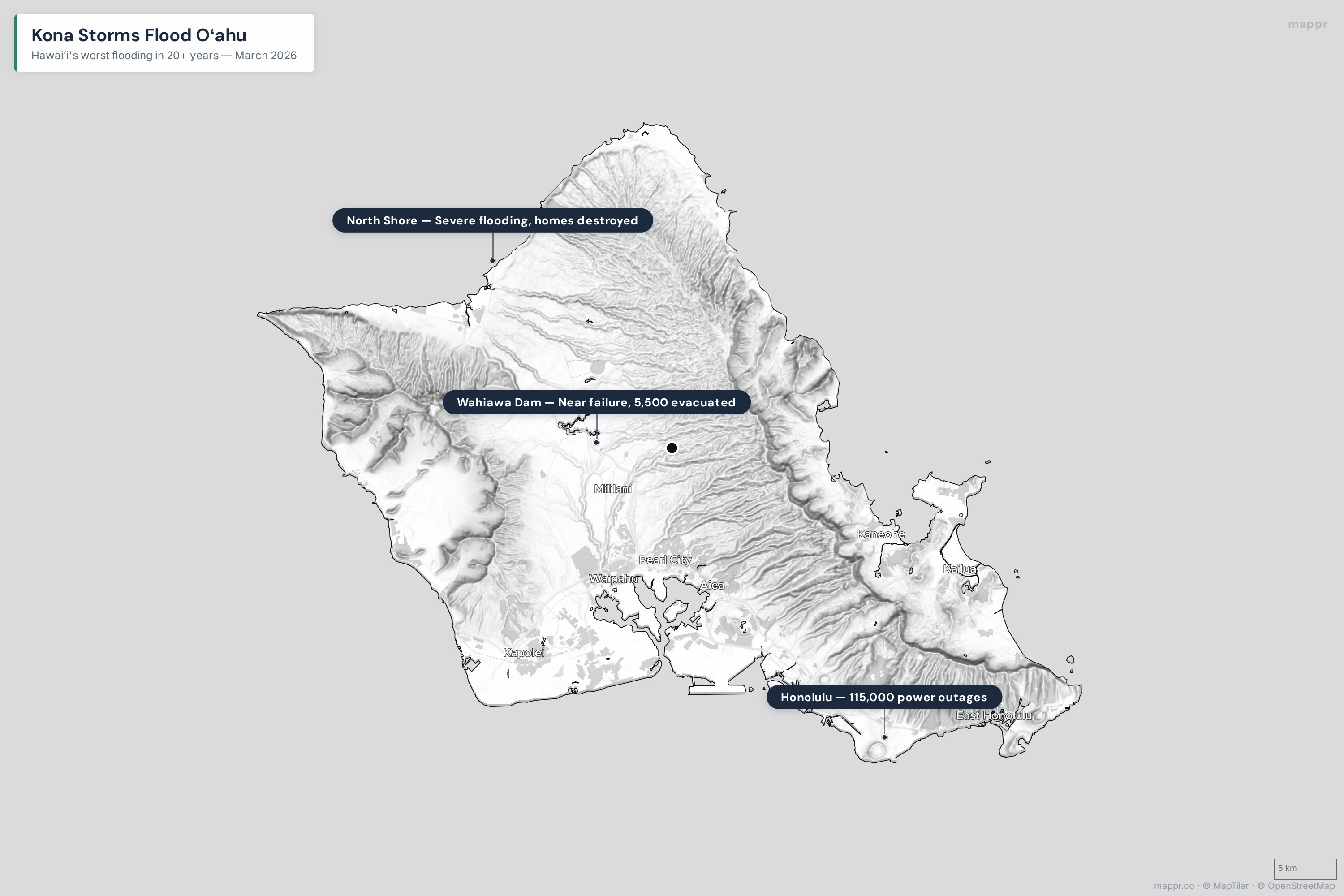
Interactive Map: Oʻahu Flood Impact Zone
Explore the flood-affected areas below. Click on markers for details about damage, evacuations, and NASA satellite observations.
What Are Kona Storms?
Under normal conditions, trade winds blow steadily from the east, keeping windward sides of the Hawaiian Islands wet while leaving leeward sides comparatively dry. A kona low flips that pattern entirely — the word “kona” is Polynesian for “leeward.”
These low-pressure systems form west to northwest of Hawaii during the cool season and tap into subtropical moisture, driving cooler, moisture-rich winds from the south to southwest. When a kona low stalls near the islands, as this one did for nearly five days, it can produce catastrophic rainfall totals.
On average, one to two kona storms affect Hawaii each season. Having two hit within the same week is extremely rare.
The Damage by the Numbers
- Rainfall: 5–10 inches across the state between March 11–15, with some areas exceeding 30 inches. The second storm dropped 22.51 inches at Kaala alone.
- Wind: Widespread gusts of 60–75 mph, with some locations recording 100+ mph. The first storm hit 135 mph at higher elevations.
- Power outages: Up to 115,000 Oʻahu residents lost electricity.
- Evacuations: 5,500 people evacuated north of Honolulu as Wahiawa Dam faced potential failure — the 120-year-old reservoir crested at 85 feet after rising 6 feet in 24 hours.
- Homes damaged: Hundreds across Oʻahu, with the North Shore communities of Haleiwa and Waialua hit hardest.
- Agricultural losses: Millions of dollars in farm damage reported statewide.
- Records broken: Weather stations in Honolulu, Hilo, Līhuʻe, and Kahului all set new daily rainfall records. Kahului recorded its wettest March ever.
What NASA’s Satellites Show
Landsat satellite imagery captured by NASA’s Earth Observatory reveals the stark before-and-after contrast on Oʻahu. Images from January 25 show green farmland and clear coastal waters between Mokuleia and Waialua. By March 14, after the first kona low, the same area is visibly swamped — floodwaters pool across neighborhoods and farmland, while massive plumes of suspended sediment discolor the waters around Kaiaka Bay.
The distinctive red-brown color of the sediment plumes comes from Hawaii’s volcanic Hilo soils, which are rich in iron and aluminum oxide.
Geographic Vulnerability
Oʻahu’s geography made the flooding especially destructive. The island’s two mountain ranges — the Koʻolau Range in the east and the Waiʻanae Range in the west — channel rainfall into the central plateau and down toward coastal communities. When a kona low reverses the normal wind pattern, the typically drier leeward North Shore suddenly receives extreme precipitation that the terrain funnels directly into low-lying towns like Haleiwa and Waialua.
The shallow soils and sparse vegetation on leeward slopes, which normally see far less rain, make these areas particularly vulnerable to landslides and flash flooding when a kona low strikes.
The Road Ahead
While the most intense rains had subsided by March 24, forecasters continue to monitor unsettled weather and the possibility of further flash floods. With the ground thoroughly saturated, even modest additional rainfall could trigger renewed flooding.
NASA’s Disasters Response Coordination System has been activated to support Hawaii’s emergency management response, posting maps and data products on its open-access mapping portal as new information becomes available.
Governor Josh Green has declared a State of Emergency, and recovery efforts are ongoing across the islands.