The flag of Mauritius encapsulates the essence of Mauritius, celebrating its rich cultural tapestry and natural splendor. It symbolizes the nation’s independence journey and steadfast commitment to progress and harmony. The flag’s distinctive colors and design embody the national character and echo the aspirations and diverse heritage of the Mauritian people.
Mauritius Flag

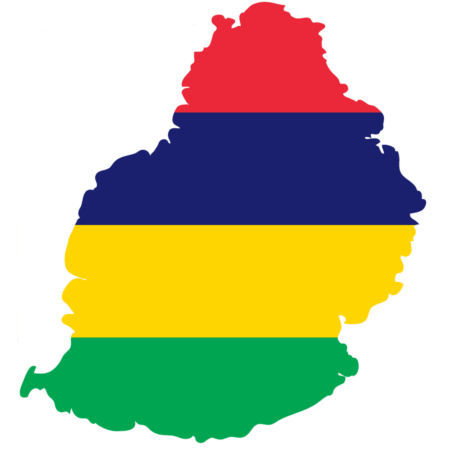
The flag of Mauritius is a striking composition of four horizontal stripes, each distinctly colored. This simple yet profound design reflects the island nation and its aspirations. The arrangement of the stripes creates a bold and clear visual statement, symbolizing Mauritius’s unique character and the essence of its landscape and history.
Mauritius Flag: Color Palette
Mauritius Flag Emoji: 🇲🇺
The color palette of the Mauritius flag is a thoughtful selection of hues, each chosen for its significant representation and symbolism. This palette harmoniously blends, creating a visually appealing and meaningful emblem. The colors are more than mere aesthetic choices; they are deeply intertwined with the nation’s ethos and narrative.
Meaning of Each Color

Red
The red stripe at the top of Mauritius’ flag symbolizes the nation’s journey towards self-determination. Historically, red often represents strength, courage, and sacrifice. In the context of Mauritius, it specifically commemorates the struggle for freedom and independence from colonial rule.
Blue
Blue signifies the Indian Ocean, a central aspect of Mauritius’ identity. The ocean not only geographically defines the island but also plays a crucial role in its economy, culture, and history. Historically, the Indian Ocean facilitated trade and cultural exchange, shaping Mauritius’ diverse society.
Yellow
The yellow stripe can be interpreted as the new light of independence, representing the dawn of a new era for Mauritius following its independence in 1968. It’s also associated with golden sunshine, symbolizing warmth, vitality, and the island’s tropical climate.
Green
Green primarily symbolizes the lush vegetation of Mauritius, its agricultural heritage, and its environmental richness. It’s a nod to the island’s natural beauty, from its dense forests to its fertile lands.
This color serves as a reminder of the importance of preserving the natural environment, which is integral to the island’s economy and way of life.
Coat of Arms of Mauritius
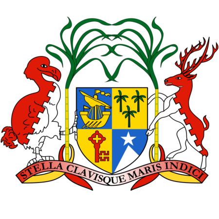
The Coat of Arms of Mauritius is a heraldic symbol representing the national identity and history of the country. Introduced on January 25, 1906, it is composed of several elements, each carrying distinct symbolism:
- Shield: The central feature of the coat of arms is a shield, divided into four quadrants, each containing a symbol representing the island’s agricultural wealth and maritime history. These include a ship (signifying the early settlers and traders), a palm tree (representing the tropical environment), a key (symbolic of strategic importance), and a sugar cane plant (highlighting the agricultural industry).
- Supporters: Flanking the shield are two animals native to the island, the dodo bird and the sambar deer, symbolizing the unique wildlife of Mauritius.
- Motto: The motto “Stella Clavisque Maris Indici” (Latin for “Star and Key of the Indian Ocean”) underscores Mauritius’ historical and geographical significance as a central hub in the Indian Ocean.
- Crest: The crest features a lymphad or ancient ship, symbolizing the island’s maritime exploration and settlement history.
- Helm and Mantling: These elements represent the ceremonial aspects of heraldry and add to the regality and dignity of the coat of arms.
This coat of arms encapsulates Mauritius’ rich history, natural and economic resources, and strategic position in the Indian Ocean, symbolizing the pride and heritage of the Mauritian nation.
Historical Evolution and the Meaning Behind Changes
The flag of Mauritius signifies a major shift from its colonial past. Before this, Mauritius was ruled by the Dutch, French, and British, with each era marked by its respective colonial flags.
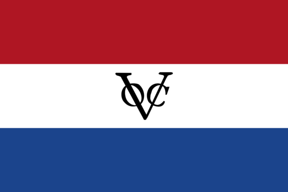
The Dutch East India Company’s flag represented the island during the Dutch colonial period, followed by the Royal Standard of France and later the national flag of France during French rule.
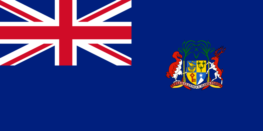
Under British colonial rule, the Union Jack and several colonial flags specifically designed for Mauritius were used, featuring the Union Jack and various iterations of the Mauritian coat of arms.
The current flag, designed by Gurudutt Moher, a Mauritian school teacher, was a significant step towards establishing a distinct national identity, representing the new, independent nation. It stands out from its predecessors by symbolizing the unity and diversity of Mauritius without the colonial symbols.
With its four horizontal bands, the flag’s design deliberately reflects the nation’s aspirations and characteristics. Since its adoption, the flag has remained unchanged, underlining its lasting significance and the unity it embodies for Mauritius.
Overall Symbolic Meaning of the Flag

The flag of Mauritius, with its four distinct colors, embodies a comprehensive narrative that mirrors the nation’s journey, natural environment, and desire for a better future. While individually significant, each color collectively represents Mauritius’s unified and cohesive story.
Similar Flags to the Flag of Mauritius
Exploring flags similar to Mauritius’s, we find a few global counterparts that echo its vibrant, multi-colored design.
Central African Republic
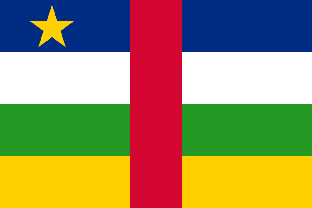
This flag features four horizontal bands of blue, white, green, and yellow, a vertical red stripe in the center, and a yellow star in the upper left corner.
Like Mauritius, it employs a range of colors to represent different aspects of the nation, with the horizontal stripes suggesting unity in diversity.
Seychelles
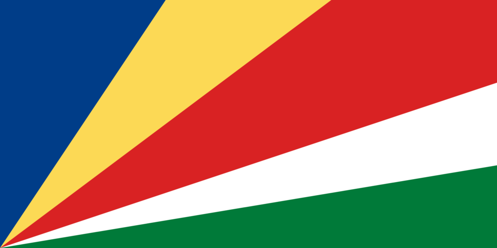
Seychelles’ flag is characterized by its radiating bands of blue, yellow, red, white, and green extending from one corner.
Although the layout differs from Mauritius’s flag, using multiple colors to symbolize various national elements creates a visual resemblance. Both flags use a colorful palette to represent their island nation’s natural beauty and diversity.
Ethiopia
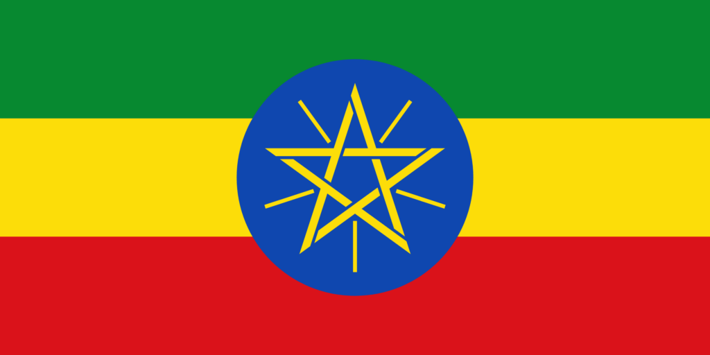
Ethiopia’s flag, comprising green, yellow, and red horizontal stripes, shares the concept of using distinct colors in horizontal layers to represent the country’s values and heritage. This similarity in using horizontal stripes and vibrant colors creates a visual connection with Mauritius’ flag.
Final Thoughts
The flag of Mauritius, with its distinctive color scheme, stands as a symbol of the nation’s unique identity and enduring spirit in the diverse tapestry of world flags. It holds a special place in the hearts of Mauritians, encapsulating their pride, heritage, and the vivid natural beauty of their homeland.
Image Sources and Copyright Information
- Mauritius Flag Waving Against Blue Sky: © Chris worldwide/Shutterstock
- Mauritius Location on Map with Flag Pin: © hyotographics/Shutterstock