Wisconsin, affectionately known as the Badger State, boasts a diverse tapestry of landscapes in the Midwestern United States.
From the dairy farms that have earned Wisconsin its reputation as America’s Dairyland to the vibrant arts and music scenes of its cities, the state encapsulates the ideal of Midwestern hospitality and culture.
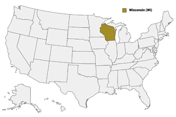
Wisconsin (WI) on the US Map
There are 72 counties in Wisconsin, each contributing its unique character to the state.
This post will guide you through the distinct features of Wisconsin’s counties, highlighting the natural beauty, economic strengths, and cultural qualities that make each one special. Our Wisconsin Counties Map shows the borders and major cities in each of the state’s counties.
Map of Wisconsin Counties
Below is a map of the 72 counties of Wisconsin (you can click on the map to enlarge it and to see the major city in each county).

Interactive Map of Wisconsin Counties
Click on any of the counties on the map to see its population, economic data, time zone, and zip code (the data will appear below the map). Data is sourced from the US Census 2021.
List of the Counties of Wisconsin:
| County | Population | Per sq. km | Largest City |
|---|---|---|---|
| Adams County | 20,505 | 12.26 | Wisconsin Dells |
| Ashland County | 16,002 | 5.91 | Ashland |
| Barron County | 46,529 | 20.82 | Rice Lake |
| Bayfield County | 16,031 | 4.19 | Ashland |
| Brown County | 267,364 | 194.74 | Green Bay |
| Buffalo County | 13,314 | 7.61 | Mondovi |
| Burnett County | 16,356 | 7.69 | Grantsburg |
| Calumet County | 52,128 | 63.24 | Appleton |
| Chippewa County | 65,877 | 25.22 | Eau Claire |
| Clark County | 34,655 | 11.06 | Stanley |
| Columbia County | 58,219 | 29.36 | Portage |
| Crawford County | 16,167 | 10.94 | Prairie du Chien |
| Dane County | 555,474 | 179.25 | Madison |
| Dodge County | 89,274 | 39.36 | Watertown |
| Door County | 29,713 | 23.8 | Sturgeon Bay |
| Douglas County | 44,034 | 13.04 | Superior |
| Dunn County | 45,254 | 20.55 | Menomonie |
| Eau Claire County | 105,206 | 63.68 | Eau Claire |
| Florence County | 4,542 | 3.59 | Florence |
| Fond du Lac County | 103,890 | 55.74 | Fond du Lac |
| Forest County | 9,184 | 3.5 | Crandon |
| Grant County | 52,210 | 17.58 | Platteville |
| Green County | 37,098 | 24.52 | Monroe |
| Green Lake County | 18,990 | 20.98 | Berlin |
| Iowa County | 23,715 | 12.01 | Dodgeville |
| Iron County | 6,074 | 3.09 | Hurley |
| Jackson County | 21,004 | 8.21 | Black River Falls |
| Jefferson County | 84,808 | 58.84 | Watertown |
| Juneau County | 26,595 | 13.39 | Mauston |
| Kenosha County | 168,743 | 239.67 | Kenosha |
| Kewaunee County | 20,535 | 23.15 | Algoma |
| La Crosse County | 120,291 | 102.8 | La Crosse |
| Lafayette County | 16,662 | 10.15 | Darlington |
| Langlade County | 19,469 | 8.63 | Antigo |
| Lincoln County | 28,378 | 12.47 | Merrill |
| Manitowoc County | 81,103 | 53.14 | Manitowoc |
| Marathon County | 137,597 | 34.38 | Wausau |
| Marinette County | 41,720 | 11.51 | Marinette |
| Marquette County | 15,515 | 13.15 | Montello |
| Menominee County | 4,318 | 4.66 | Legend Lake |
| Milwaukee County | 939,123 | 1501.55 | Milwaukee |
| Monroe County | 46,091 | 19.75 | Sparta |
| Oconto County | 38,691 | 14.98 | Oconto |
| Oneida County | 37,468 | 12.99 | Rhinelander |
| Outagamie County | 189,620 | 114.83 | Appleton |
| Ozaukee County | 91,029 | 150.83 | Mequon |
| Pepin County | 7,328 | 12.2 | Durand |
| Pierce County | 42,204 | 28.39 | River Falls |
| Polk County | 44,806 | 18.92 | Amery |
| Portage County | 70,378 | 33.93 | Stevens Point |
| Price County | 14,003 | 4.31 | Park Falls |
| Racine County | 197,379 | 229.1 | Racine |
| Richland County | 17,353 | 11.43 | Richland Center |
| Rock County | 163,522 | 87.91 | Janesville |
| Rusk County | 14,182 | 5.99 | Ladysmith |
| Sauk County | 65,428 | 30.38 | Baraboo |
| Sawyer County | 17,813 | 5.47 | Hayward |
| Shawano County | 40,836 | 17.65 | Shawano |
| Sheboygan County | 117,528 | 88.71 | Sheboygan |
| St. Croix County | 92,495 | 49.45 | River Falls |
| Taylor County | 19,960 | 7.9 | Medford |
| Trempealeau County | 30,504 | 16.07 | Arcadia |
| Vernon County | 30,719 | 14.98 | Viroqua |
| Vilas County | 22,813 | 10.27 | Lac du Flambeau |
| Walworth County | 105,945 | 73.65 | Whitewater |
| Washburn County | 16,561 | 8.02 | Spooner |
| Washington County | 136,300 | 122.2 | West Bend |
| Waukesha County | 405,332 | 284.69 | Waukesha |
| Waupaca County | 51,769 | 26.73 | New London |
| Waushara County | 24,527 | 15.12 | Berlin |
| Winnebago County | 171,304 | 152.15 | Appleton |
| Wood County | 74,107 | 36.08 | Wisconsin Rapids |
Largest Counties in Wisconsin by Population
Milwaukee County
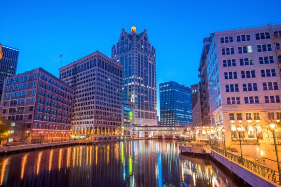
Milwaukee County, established in 1834, is the most populous county in Wisconsin, with the city of Milwaukee as its county seat and largest city.
This urban center on the western shore of Lake Michigan is known for its brewing industry heritage, which is celebrated in various breweries and the MillerCoors Brewing Company offering tours that delve into the city’s history of beer production.
The county is a cultural hub, home to the Milwaukee Art Museum, with its striking architecture and extensive collection, and the Milwaukee Public Museum, offering exhibits on natural and human history. The performing arts scene is vibrant, featuring institutions like the Milwaukee Symphony Orchestra and the Milwaukee Repertory Theater.
Milwaukee’s lakefront area is a focal point for community activities, hosting festivals like Summerfest, billed as the world’s largest music festival, alongside parks and recreational trails. The county’s park system, known as the “emerald necklace,” includes over 150 parks and green spaces, offering a wide range of outdoor activities from golfing to kite flying on the lakefront.
Dane County
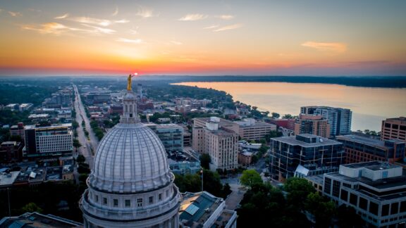
Dane County, established in 1836, is centered around Madison, Wisconsin’s state capital and the county seat. This county is known for its blend of natural beauty, academic excellence, and political activism, with the University of Wisconsin-Madison playing a significant role in the cultural and economic life of the area. The university contributes to a lively arts scene, innovative research, and a strong sense of community engagement.
Madison, situated between Lake Mendota and Lake Monona, offers residents and visitors alike a range of outdoor activities, from biking along the extensive network of trails to sailing and ice fishing on the lakes. The city’s downtown is vibrant, with the State Capitol building, numerous restaurants, shops, and entertainment venues, as well as the renowned Dane County Farmers’ Market, the largest producer-only farmers’ market in the U.S.
Waukesha County
Waukesha County, established in 1846, lies in southeastern Wisconsin, part of the Milwaukee metropolitan area. The county seat, Waukesha, once famed for its spring water, is now a suburban city with a rich historical background evident in its preserved Victorian architecture and the historic downtown area.
The county is characterized by a mix of urban development and natural beauty, with numerous lakes, parks, and recreational trails that cater to outdoor enthusiasts. Pewaukee Lake, the largest in the county, is a popular destination for boating, fishing, and water sports.
Cultural events and institutions, such as the Waukesha County Fair, the oldest fair in the state, and the Wilson Center for the Arts, provide residents and visitors with enriching experiences, from live music and theater to educational programs and art exhibitions. The extensive trail system, including the Glacial Drumlin State Trail, offers scenic routes for cyclists and hikers, connecting various communities within the county and beyond.
Brown County
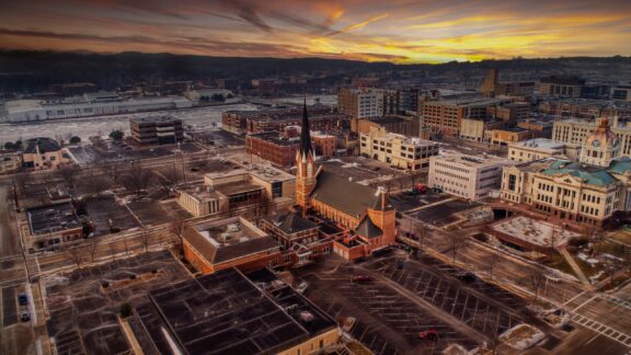
Brown County, created in 1818, is located in northeastern Wisconsin, with Green Bay as its county seat and largest city. This area is deeply rooted in both the history of Wisconsin and the early development of the United States, with the city of Green Bay being one of the oldest European settlements in America.
The county’s geographical features include the bay itself, which provides numerous recreational opportunities such as boating, fishing, and watersports, as well as access to the Door Peninsula and the larger Lake Michigan. The Green Bay Botanical Garden and the NEW Zoo & Adventure Park are notable attractions, offering educational and leisure activities that engage residents and visitors with the natural world.
In addition to sports and recreation, Brown County has a vibrant arts scene, with the Weidner Center for the Performing Arts and the Meyer Theatre hosting a wide range of cultural events, from concerts to Broadway productions. The region’s economy is diverse, encompassing manufacturing, healthcare, and education, with a significant presence in the paper and shipping industries due to its strategic location on the bay.
Racine County
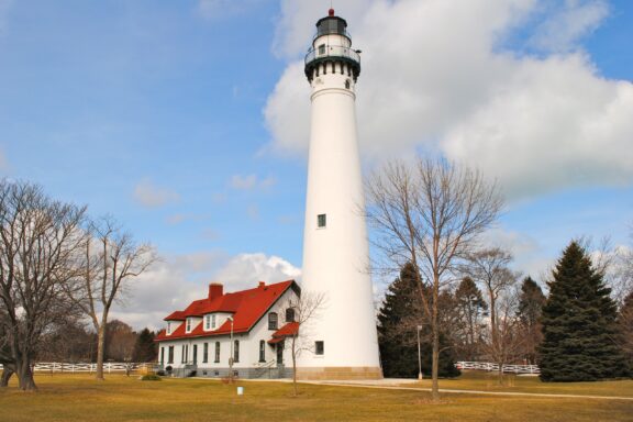
Racine County, established in 1836, is situated along the shores of Lake Michigan in southeastern Wisconsin.
The county seat, Racine, is known for its architectural heritage, including works by Frank Lloyd Wright, notably the SC Johnson Wax Administration Building and Research Tower, which exemplify innovative design and are open for tours. The city’s lakefront location has fostered a strong maritime history, visible at the Racine Heritage Museum and through the active harbor, which supports both recreational and commercial activities.
The county’s economy is diverse, with manufacturing playing a significant role, complemented by sectors such as healthcare, education, and services. Racine County is also home to the Wind Point Lighthouse, one of the oldest and tallest active lighthouses on the Great Lakes, offering guided tours and panoramic views from its tower.
Outdoor recreation in Racine County is varied, with numerous parks, golf courses, and the Root River providing opportunities for fishing, kayaking, and nature observation. The annual Racine County Fair in Union Grove is a highlight for the community, showcasing local agriculture, crafts, and entertainment, reflecting the county’s blend of urban and rural lifestyles.
Smallest Counties in Wisconsin by Population
Menominee County
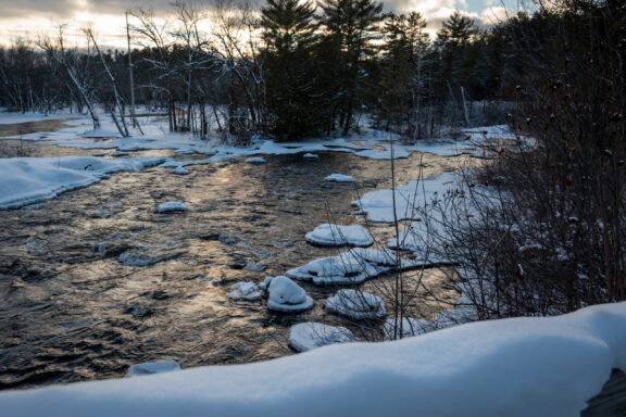
Menominee County, created in 1959, is unique within Wisconsin for its demographic and geographic characteristics, being the state’s least populous county and the only one located entirely within a Native American reservation.
The Menominee Indian Reservation, home to the Menominee Tribe, encompasses the entirety of the county, including the county seat of Keshena. This area is known for its vast stretches of untouched wilderness, dense forests, and the Wolf River, which runs through the reservation, offering pristine conditions for fishing, whitewater rafting, and nature exploration.
The Menominee Forest is one of the oldest sustained-yield forestry practices in the United States, demonstrating the tribe’s commitment to environmental stewardship and sustainable land management. This forest not only provides recreational opportunities but also serves as a living classroom for ecological and cultural education, highlighting the Menominee people’s deep connection to the land.
Cultural significance is celebrated through events like the annual Menominee Pow-Wow, an important cultural gathering that brings together tribal members and visitors to share in traditional dances, music, and crafts, fostering a sense of community and heritage preservation.
Florence County
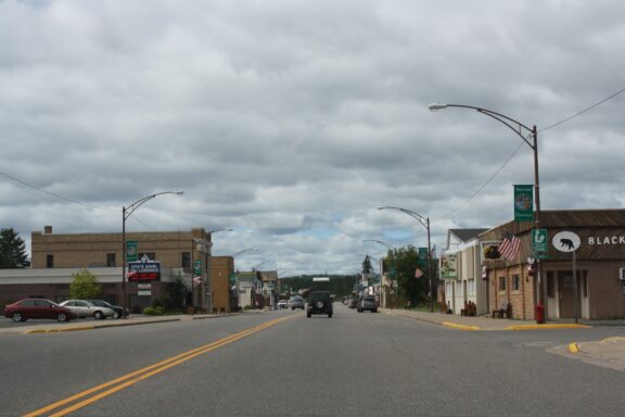
Florence County, established in 1882, is nestled in the northeastern corner of Wisconsin, bordering the Upper Peninsula of Michigan. With its county seat in the town of Florence, the area is characterized by its dense forests, numerous waterways, and the natural beauty of the Northwoods. This sparsely populated county is a haven for outdoor enthusiasts, offering extensive recreational opportunities throughout the year.
The county’s landscape is dominated by the Pine and Popple Wild Rivers, both designated as Wisconsin Wild Rivers, preserving their natural state and offering exceptional settings for kayaking, fishing, and scenic photography.
The Nicolet National Forest covers a significant portion of the county, providing miles of trails for hiking, mountain biking, snowmobiling, and cross-country skiing, allowing residents and visitors to immerse themselves in the serene and untouched wilderness.
Iron County
Iron County, established in 1893, is located in the far northern reaches of Wisconsin, embodying the rugged spirit of the Northwoods. The county seat, Hurley, is known for its rich mining history, which is echoed in the community and landscape. The region’s past is intricately linked to the iron ore that once drove its economy, a heritage preserved and celebrated in local museums and historical sites.
This county is characterized by its vast forests, clear lakes, and the Montreal River, which forms a natural boundary with Michigan’s Upper Peninsula. Iron County is a paradise for outdoor enthusiasts, offering a plethora of activities such as skiing at the Whitecap Mountains Resort, exploring the extensive network of snowmobile and ATV trails, and kayaking or canoeing on the serene waters of the Turtle-Flambeau Flowage.
The area’s natural beauty is showcased in the Penokee Range, inviting hikers and nature lovers to explore its trails and discover panoramic views. The county’s commitment to preserving its natural and cultural resources while welcoming visitors and adventurers contributes to its appeal as a destination for those seeking both solitude and community in the Wisconsin Northwoods.
Other Notable Counties in Wisconsin
Door County
Door County, often referred to as the “Cape Cod of the Midwest,” stretches across a narrow peninsula between Green Bay and Lake Michigan in Wisconsin. This county is famed for its natural beauty, including more than 300 miles of shoreline dotted with lighthouses, state parks, and picturesque harbors. The county seat, Sturgeon Bay, serves as both a historical hub and a gateway to the county’s numerous attractions.
Door County’s appeal lies in its outdoor activities—sailing, kayaking, fishing, and hiking are popular among both locals and visitors. The region’s state parks, such as Peninsula State Park and Potawatomi State Park, offer extensive trails, camping facilities, and breathtaking views.
The arts play a significant role in Door County’s community, with galleries, theaters, and music venues offering a rich cultural experience. The Peninsula School of Art and the annual Door County Plein Air Festival showcase the area’s artistic talents and natural inspiration.
Marathon County
Marathon County, positioned in central Wisconsin, is distinguished by its status as the largest county in the state by land area.
Wausau, the county seat, is a focal point for culture and commerce within the region, offering a blend of urban amenities and natural beauty. The landscape of Marathon County is marked by rolling hills and fertile lands, making it a productive area for agriculture, especially ginseng farming, which is celebrated annually at the International Wisconsin Ginseng Festival in Wausau.
The county is also known for Rib Mountain State Park, home to one of the oldest geologic formations on earth, offering year-round recreational activities with hiking trails, skiing slopes, and an observation tower that provides expansive views of the surrounding area. The Wisconsin River cuts through the heart of the county, offering water sports and fishing opportunities, while the Nine Mile Forest Recreation Area caters to mountain bikers, cross-country skiers, and trail runners.
Marathon County’s dedication to the arts is evident in its support for the Leigh Yawkey Woodson Art Museum in Wausau, internationally known for its Birds in Art exhibition, drawing artists and enthusiasts from around the globe.
Bayfield County
Bayfield County is located in the northernmost region of Wisconsin, bordering the pristine waters of Lake Superior. It’s renowned for its access to the Apostle Islands National Lakeshore, a breathtaking archipelago of 21 islands known for their natural beauty, historic lighthouses, and unique sea caves accessible by kayak or boat tours.
The county seat, Washburn, offers a quaint small-town atmosphere, serving as a gateway to the outdoor adventures the area is known for.
The county’s diverse landscape includes not only the lakeshore but also vast forests and the Chequamegon National Forest, offering miles of trails for hiking, mountain biking, and in the winter, snowshoeing and cross-country skiing. Bayfield County’s commitment to preserving its natural environment is evident in its numerous parks and protected areas.
Columbia County
Columbia County, nestled in south-central Wisconsin, is characterized by its rolling hills, fertile farmland, and scenic river landscapes. The Wisconsin River, a defining feature of the county, offers ample opportunities for boating, fishing, and waterside recreation.
Portage, the county seat, holds a significant place in Wisconsin’s history as a key trading post and explorers’ hub, where the Fox and Wisconsin Rivers nearly meet, once facilitating early transportation and commerce.
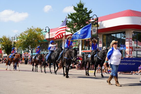
The county is also home to the city of Wisconsin Dells, widely recognized as the “Waterpark Capital of the World.” This area draws visitors from across the globe to its numerous indoor and outdoor waterparks, theme parks, and entertainment complexes.
Beyond the thrill rides and water slides, the natural beauty of the Dells area, with its unique sandstone formations along the river, captivates those interested in outdoor adventures and scenic exploration.
Eau Claire County
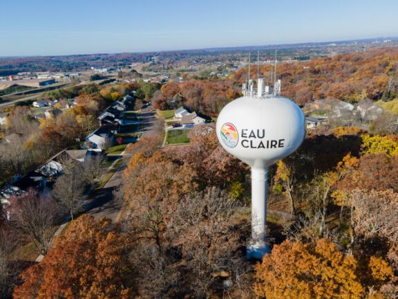
Eau Claire County, established in 1856, lies in the heart of Wisconsin, with the city of Eau Claire serving as both the county seat and a cultural nexus for the region. This county is known for its convergence of rivers, with the Eau Claire and Chippewa Rivers meeting within the city, creating scenic waterfront parks and providing opportunities for water-based activities like kayaking and fishing.
The city of Eau Claire has gained recognition for its vibrant arts scene, hosting music festivals such as the Eaux Claires, founded by musician Justin Vernon of Bon Iver, and the Blue Ox Music Festival, which celebrate the county’s rich musical heritage. The Pablo Center at the Confluence stands as a testament to the community’s commitment to the arts, offering a venue for performances, exhibitions, and community events.
The county’s extensive trail system, including the Chippewa River State Trail, invites residents and visitors to explore the natural beauty of the area on foot or by bike, enhancing the outdoor lifestyle that defines the region.
More About Wisconsin Counties: FAQs
Which Wisconsin county has the highest elevation?
Price County features Timms Hill, Wisconsin’s highest natural point, with an elevation of 1,951.5 ft (595 m).
Which Wisconsin county is considered the most liberal?
Dane County is often considered the most liberal, largely due to the influence of Madison and the University of Wisconsin.
Which county in Wisconsin is known for having the oldest population?
Iron County has one of the oldest median-age populations in the state and the nation.
Which Wisconsin county has the highest number of lakes?
Vilas County, in the Northwoods, is renowned for having the highest number of lakes.

- Milwaukee County Downtown — © f11photo/Shutterstock
- Wide Aerial Shot Of A Dramatic Fiery Sunrise Over The — © Szymon Raczkowiak/Shutterstock
- A Landscape Crop Of A Wisconsin Lake Lower Genesee Lake — © Jennifer Tepp/Shutterstock
- Aerial View Of Green Bay During Sunset — © Randy Kostichka/Shutterstock
- Racine County Wind Point Lighthouse Racine Wisconsin — © cdsphotos/Shutterstock
- River Near Keshena In Wisconsin — © Ilia Bordiugov/Shutterstock
- Florence Wisconsindowntownus Us — © Royalbroil/Wikimedia Commons
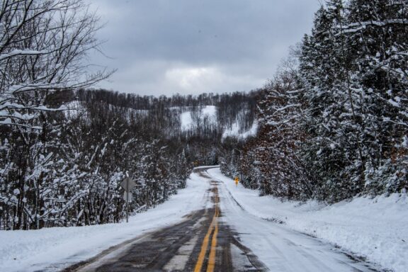
- An Empty Snow Covered Road After A Fresh Snow In — © Alex Nemec/Shutterstock
- Sister Bay Town Harbour View In Door County Of Wisconsin — © Nejdet Duzen/Shutterstock
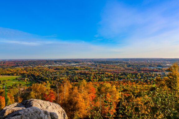
- Wausau Wisconsin From The Summit Of Granite Peak — © Michael Tatman/Shutterstock
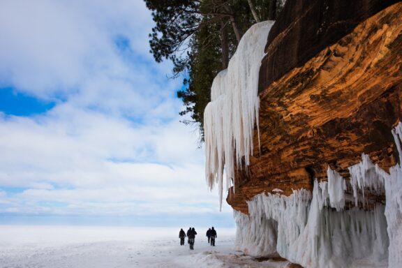
- Bayfield County Frozen Lake Superior Shoreline Orange Cliff — © James.Pintar/Shutterstock
- Wisconsin Dells Wisconsin Usa September Th : Members From — © Aaron of L.A. Photography/Shutterstock
- Aerial View Of Eau Claire Wisconsin Water Tower Fall Foliage — © cflaten/Shutterstock