Nestled in the Northeastern United States, Vermont is a state celebrated for its natural beauty, from the Green Mountains that stretch across its landscape to the serene waters of Lake Champlain on its western border.
Known as the Green Mountain State, Vermont boasts a rich tapestry of dense forests, rolling hills, and picturesque small towns that each contribute to its distinct New England charm.
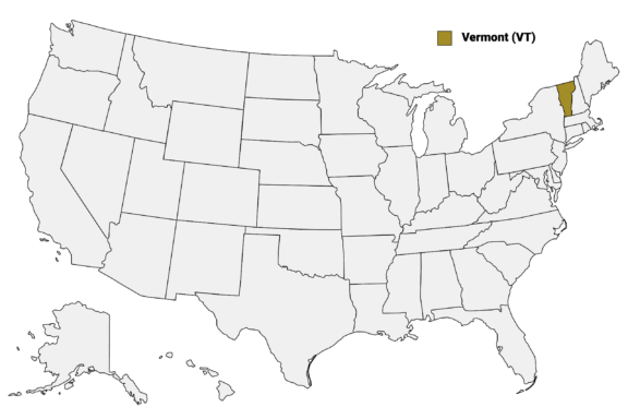
Vermont (VT) on the US Map
Vermont is divided into 14 counties, each with its unique character and attractions. From the historic architecture and vibrant arts scene of Chittenden County to the remote, untouched wilderness of Essex County in the “Northeast Kingdom,” Vermont’s counties offer a diverse range of experiences.
In this post, we provide a detailed Vermont Counties Map and take a closer look at each of the state’s counties.
Map of Vermont Counties
Below is a map of the 14 counties of Vermont (you can click on the map to enlarge it and to see the major city in each county).
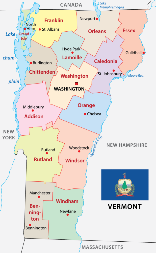
Interactive Map of Vermont Counties
Click on any of the counties on the map to see its population, economic data, time zone, and zip code (the data will appear below the map). Data is sourced from the US Census 2021.
List of the Counties of Vermont:
| County | Population | Per sq. km | Largest City |
|---|---|---|---|
| Addison County | 37,306 | 18.8 | Middlebury |
| Bennington County | 37,235 | 21.32 | Bennington |
| Caledonia County | 30,402 | 18.08 | St. Johnsbury |
| Chittenden County | 167,523 | 120.48 | Burlington |
| Essex County | 5,972 | 3.48 | Lunenburg |
| Franklin County | 49,752 | 30.44 | St. Albans |
| Grand Isle County | 7,249 | 34.23 | Grand Isle |
| Lamoille County | 25,920 | 21.7 | Morristown |
| Orange County | 29,286 | 16.46 | Randolph |
| Orleans County | 27,317 | 15.19 | Derby |
| Rutland County | 60,662 | 25.17 | Rutland |
| Washington County | 59,609 | 33.5 | Barre |
| Windham County | 45,811 | 22.5 | Brattleboro |
| Windsor County | 57,593 | 22.94 | Hartford |
Addison County

Population: 37,306
Largest City: Middlebury
Addison County, established in 1785, is nestled in the western part of Vermont, featuring a landscape marked by the rolling hills of the Green Mountains and the fertile lands of the Champlain Valley. Middlebury, the county seat, is home to Middlebury College, an institution that contributes significantly to the cultural and academic vibrancy of the area.
The county is renowned for its picturesque farms, historic covered bridges, and extensive network of hiking trails, including parts of the Long Trail, the oldest long-distance hiking trail in the United States. The shores of Lake Champlain offer recreational opportunities such as boating, fishing, and swimming, while the lake’s islands and shorelines provide habitats for diverse wildlife.
Addison County hosts the annual Middlebury Festival on the Green, a celebration of music and community, and the county fair, which showcases its agricultural heritage. The region’s wineries and orchards reflect its growing reputation as a hub for local food and drink, contributing to Vermont’s farm-to-table movement.
Bennington County

Population: 37,235
Largest City: Bennington
Bennington County, Vermont’s oldest county, was established in 1778. It is situated in the southwestern corner of the state, embodying Vermont’s historical roots and natural beauty. The county seat, also named Bennington, is known for the Bennington Battle Monument, a towering structure commemorating a significant Revolutionary War victory.
The county is a gateway to the Green Mountains, with the Appalachian Trail and the Long Trail providing miles of hiking paths through scenic forests and along mountain ridges. Bennington County’s landscape includes the serene waters of Lake Shaftsbury State Park and the expansive views from Mount Equinox.
Manchester, another key town in Bennington County, serves as a cultural and shopping destination with its designer outlets, local boutiques, and the Southern Vermont Arts Center. The town is also a gateway to winter sports, with nearby ski resorts offering slopes for all skill levels.
The arts play a vital role in Bennington County’s identity, with the Bennington Museum showcasing the largest public collection of Grandma Moses paintings and the Oldcastle Theatre Company presenting professional stage productions.
Caledonia County

Population: 30,402
Largest City: St. Johnsbury
Caledonia County, organized in 1796, is located in northeastern Vermont, offering a blend of natural landscapes and historic charm. St. Johnsbury, the county seat, is notable for its well-preserved Victorian architecture and the Fairbanks Museum and Planetarium, a center for natural science education in the region.
The county is characterized by the rolling hills and valleys of the Northeast Kingdom, providing a picturesque setting for outdoor activities. Burke Mountain, located within Caledonia County, is a popular destination for skiing and mountain biking, known for its challenging trails and beautiful vistas.
The area’s rivers and lakes, including Harvey Lake and Joe’s Pond, offer opportunities for fishing, boating, and swimming, making Caledonia County a favorite among those seeking tranquility and outdoor adventure.
Agriculture remains a cornerstone of the county’s economy, with local farms producing maple syrup, dairy products, and fresh produce. The annual Caledonia County Fair, one of the oldest in Vermont, celebrates this agricultural heritage with exhibitions, competitions, and entertainment.
Chittenden County

Population: 167,523
Largest City: Burlington
Chittenden County, created in 1787, is situated in northwestern Vermont and is the state’s most populous county.
Burlington, the county seat, is Vermont’s largest city and serves as a cultural and economic hub for the region. The city’s waterfront on Lake Champlain offers stunning views and access to recreational activities, including sailing and kayaking. The vibrant Church Street Marketplace, a pedestrian-only shopping and dining area, is at the heart of Burlington’s bustling downtown.
The University of Vermont and Champlain College are both located in Burlington, adding to the city’s youthful energy and fostering a community rich in educational and cultural opportunities. The Flynn Center for the Performing Arts hosts performances ranging from local theater productions to international music acts, contributing to Burlington’s reputation as a center for arts and entertainment in Vermont.
Chittenden County is also known for its commitment to sustainability and conservation, with extensive bike paths, community gardens, and green initiatives. The county’s parks, such as the Shelburne Farms and the Intervale Center, offer educational programs on agriculture and environmental stewardship, promoting a connection to the land and local food production.
Outdoor enthusiasts enjoy the county’s access to the Green Mountains for hiking and skiing, particularly at resorts like Bolton Valley, which provide year-round outdoor activities. Chittenden County’s blend of urban vibrancy and natural beauty makes it a unique and dynamic part of Vermont.
Essex County

Population: 5,972
Largest City: Lunenburg
Essex County, established in 1792, lies in Vermont’s northeastern corner, known as the “Northeast Kingdom” for its vast, untouched wilderness. Guildhall, the county seat, typifies the region’s sparse population and rural character.
The county is a paradise for outdoor lovers, with the Connecticut River and Maidstone Lake offering prime spots for fishing, kayaking, and canoeing. Its extensive forests provide secluded trails for hiking and, in winter, become a snowy haven for snowmobiling and cross-country skiing.
Essex County’s remote beauty is preserved in places like the Silvio O. Conte National Fish and Wildlife Refuge, which spans part of the county. This area supports diverse wildlife and offers educational opportunities about conservation and the importance of natural habitats.
Franklin County

Population: 49,752
Largest City: St. Albans
Franklin County, established in 1792, is nestled in northwestern Vermont, bordered by Lake Champlain and Canada. St. Albans, the county seat, is known for its rich history, particularly during the Civil War era, and vibrant downtown area.
Agriculture plays a crucial role in Franklin County’s economy, with dairy farming leading the way. The annual Vermont Dairy Festival in Enosburg Falls celebrates this heritage, featuring local products, crafts, and entertainment.
There are also plenty of outdoor activities in Franklin County, with Lake Champlain offering boating and fishing, and the Missisquoi National Wildlife Refuge providing trails for walking and bird watching amidst wetlands and forests.
The county’s commitment to community and tradition is evident in its local festivals and events, including the St. Albans Maple Festival, which showcases the region’s significant maple syrup production. This blend of natural beauty, history, and community spirit makes Franklin County a quintessential part of Vermont’s landscape.
Grand Isle County

Population: 7,249
Largest City: Grand Isle
Grand Isle County, created in 1802, is Vermont’s smallest by area, uniquely comprising several islands and peninsulas in Lake Champlain. Its county seat, North Hero, embodies the tranquil, tight-knit community atmosphere prevalent throughout the area.
The county is celebrated for its stunning lake views, outdoor recreation, and abundant fishing opportunities. Grand Isle State Park and Knight Point State Park are popular destinations, offering camping, kayaking, and swimming. The area’s scenic beauty is perfect for leisurely bike rides or drives along the lakeshore, with the Lake Champlain Byway running through the heart of the county.
Agriculture, especially apple orchards and vineyards, plays a significant role in the local economy, with several farms open to the public for tours and tastings. The annual Champlain Islands Farmers’ Market highlights the county’s commitment to local produce and crafts.
Lamoille County

Population: 25,920
Largest City: Morristown
Lamoille County, established in 1835, lies in north-central Vermont, with Hyde Park as its county seat. The county is renowned for its outdoor recreational opportunities, centered around the Green Mountains. Stowe, one of Vermont’s premier resort towns, offers year-round activities, from skiing and snowboarding at Stowe Mountain Resort in the winter to hiking and biking along the Stowe Recreation Path in warmer months.
The county also hosts the Lamoille Valley Rail Trail, a multi-use path offering scenic views perfect for biking, walking, and in winter, snowmobiling. Morrisville, another key town, provides access to water activities on the Lamoille River.
Lamoille County is a hub for craft brewing, with several breweries contributing to Vermont’s esteemed craft beer scene. The area’s agricultural roots are celebrated in local farmers’ markets and festivals, showcasing the county’s dedication to farm-to-table dining and sustainable practices.
Orange County

Population: 29,286
Largest City: Randolph
Orange County, formed in 1781, is located in the eastern part of Vermont and features rolling hills and fertile valleys. Chelsea, the county seat, captures the quintessential New England charm with its historic homes and public buildings. The county is dotted with small villages and towns that host a variety of community events, reflecting a strong sense of local pride.
The area is known for its outdoor activities, with the Connecticut River providing opportunities for fishing, boating, and kayaking. The Tunbridge World’s Fair, an annual event held in Orange County, draws visitors from across the region to celebrate Vermont’s agricultural heritage with livestock shows, craft exhibits, and carnival rides.
Hiking enthusiasts enjoy the trails in the Groton State Forest, which offer access to several pristine lakes and ponds, as well as panoramic views from Owl’s Head Mountain.
Orleans County

Caption: Newport, Vermont and Lake Memphremagog
Attribute: © NEKVT/Shutterstock
Population: 27,317
Largest City: Derby
Orleans County, incorporated in 1792, is in the northernmost part of Vermont, bordering Canada. Newport, the county seat, sits on the southern shore of Lake Memphremagog, extending into Quebec. This international lake is a focal point for recreation, offering boating, fishing, and swimming.
The area is celebrated for its stunning natural scenery, including Jay Peak Resort, which attracts skiing and snowboarding enthusiasts with its challenging slopes and receives some of the highest snowfall totals in the Northeast. In the summer, the resort transforms into a haven for hikers and mountain bikers.
Orleans County’s landscape is also marked by its vast farmlands and forests, contributing to the local economy through dairy farming, maple syrup production, and logging. The county’s small towns and villages, such as Derby and Barton, host vibrant community events that highlight the region’s history and culture, like the annual Orleans County Fair in Barton, a tradition that dates back over a century.
Rutland County

Population: 60,662
Largest City: Rutland
Rutland County, established in 1781, is located in central Vermont, with the city of Rutland as its county seat. Rutland, the third-largest city in the state, is a hub for commerce and culture, offering a diverse array of shops, restaurants, and entertainment options. The Paramount Theater, a restored 1914 venue, showcases performances ranging from local plays to national touring acts.
The county is known for its outdoor recreational opportunities, including skiing and snowboarding at Killington and Pico Mountain resorts, which draw winter sports enthusiasts from across the region. In warmer months, the area’s mountains and lakes, such as Lake Bomoseen, provide ideal settings for hiking, fishing, and boating.
Rutland County’s agricultural heritage is evident in its numerous farms and orchards, with autumn apple picking and spring maple sugaring being popular activities. The annual Vermont State Fair in Rutland showcases this agricultural tradition, featuring livestock exhibits, carnival rides, and local food.
Washington County

Population: 59,609
Largest City: Barre
Washington County, established in 1810, is located in central Vermont, with Montpelier, the state capital, serving as the county seat. Montpelier, known for its picturesque downtown and as the smallest state capital in the United States, boasts a vibrant community with independent shops, cafes, and the Vermont State House, a beautifully maintained historic building and the seat of state government.
The county is also home to Barre, renowned for its granite quarrying and carving industry, which has earned it the title of “Granite Capital of the World.” The Rock of Ages quarry and the Vermont Granite Museum in Barre highlight the importance of granite to the area’s history and economy.
Outdoor activities abound in Washington County, with the Green Mountains offering hiking, skiing, and snowboarding opportunities. The Mad River Valley, encompassing towns like Waitsfield and Warren, is particularly popular for its ski resorts, scenic landscapes, and vibrant arts scene.
Recreational waterways, such as the Winooski River and Waterbury Reservoir, provide residents and visitors with opportunities for kayaking, fishing, and swimming, showcasing the county’s natural beauty and outdoor lifestyle.
Windham County

Population: 45,811
Largest City: Brattleboro
Windham County, established in 1779, is located in the southeastern corner of Vermont, embodying the state’s scenic beauty and vibrant community life. Brattleboro, the largest town, serves as a cultural hub, known for its lively arts scene, with galleries, theaters, and the annual Brattleboro Film Festival attracting creatives and enthusiasts alike.
The county is celebrated for its outdoor recreational opportunities, highlighted by the Green Mountains and the Connecticut River that define its landscapes. Skiing and snowboarding are popular at Mount Snow, a resort that draws winter sports enthusiasts for its trails and terrain parks. In warmer months, the region’s trails and waterways offer hiking, kayaking, and fishing activities.
Windham County’s commitment to sustainability and local agriculture is evident in its numerous farmers’ markets and community-supported agriculture programs. The town of Putney, for example, is home to diverse farms and artisan food producers, contributing to Vermont’s reputation for farm-to-table dining.
Windsor County

Population: 57,593
Largest City: Hartford
Windsor County, established in 1781, is located in eastern Vermont and is the state’s largest county by area. Woodstock, its county seat, epitomizes New England charm with its historic homes, covered bridges, and a vibrant town green hosting community events. The county is known for its picturesque landscapes, including the Quechee Gorge, often referred to as Vermont’s Grand Canyon, providing stunning views and hiking opportunities.
Windsor County’s rich history is preserved at sites like the Marsh-Billings-Rockefeller National Historical Park in Woodstock, showcasing conservation history and sustainable forestry practices. The Simon Pearce glassblowing workshop and retail store in Quechee is an example of the county’s dedication to artisan crafts.
Agriculture remains a vital part of Windsor County’s economy, with farms producing cheese, maple syrup, and apples. The annual Vermont Cheese Council’s Cheese Festival celebrates this tradition, drawing visitors to sample local products and meet the producers.
More About Counties in Vermont: FAQs
Where is the Ben & Jerry’s factory located in Vermont?
The Ben & Jerry’s factory is located in Washington County, near Waterbury.
Which county in Vermont has the lowest population?
Essex County is the least populous of any county in Vermont.
Which Vermont counties are known as the Northeast Kingdom?
The Northeast Kingdom is primarily located in Caledonia, Essex, and Orleans counties.
Which Vermont county is known for the annual Quechee Hot Air Balloon Festival?
The Quechee Hot Air Balloon Festival is held in Windsor County.

- Moss Glen Falls in Lush Green Forest — © Steven Noroian/Shutterstock
- Autumn View of Bennington Battle Monument Along a Tree-Lined Street — © lucasImages/Shutterstock
- Sunny Afternoon on a Small Town Main Street — © Wangkun Jia/Shutterstock
- Sunny Day on a Bustling Pedestrian Street in Burlington, Vermont with Historic Church in the Background — © E Pasqualli/Shutterstock
- Aerial View of Maidstone Lake Surrounded by Autumn Foliage in Essex County, Vermont — © NEKVT/Shutterstock
- Autumn Colors Adorning the Trees by a Field in Franklin County, St. Albans, Vermont — © Hank Shiffman/Shutterstock
- Lakeside Musical Performance in Grand Isle County, Vermont — © vermontalm/Shutterstock
- Aerial View of Morning Fog Blanketing Autumn-Colored Forest in Lamoille County — © Joseph Sohm/Shutterstock
- Whale Tail Sculpture Amidst Green Landscape with Blue Skies — © EWY Media/Shutterstock
- Summer Street Fair in a Bustling Downtown Area — © Wirestock Creators/Shutterstock
- Autumnal Hues Over Montpelier: A Scenic View of Vermont’s Capital City Amidst Fall Foliage — © Sean Pavone/Shutterstock
- Aerial View of a Snow-Covered Town with River in Winter — © Mark F Lotterhand/Shutterstock
- Autumn Foliage Surrounding Quechee Gorge with Scenic Bridge in Hartford, Vermont — © Elliott Kresse/Shutterstock