Situated in the Western United States, Utah is surrounded by five states and is famed for its astonishing natural diversity. Often referred to as “The Beehive State,” Utah boasts a rich array of landscapes, from the snow-capped peaks of the Wasatch Range to the stark, red sandstone deserts of Southern Utah.
One of Utah’s greatest claims to fame is its five national parks, known as the “Mighty 5,” including Zion, Bryce Canyon, Capitol Reef, Arches, and Canyonlands. The state’s natural beauty is complemented by its vibrant cities and towns, which serve as gateways to outdoor adventures and cultural experiences.
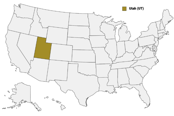
Utah (UT) on the US Map
There are 29 counties in Utah, each with a unique identity. Most of the state’s population lives in just four of these counties: Salt Lake, Utah, Davis, and Weber. In this post, we’ll learn more about the state’s counties, starting with the most populous. Below is a Utah Counties Map that shows the state’s county borders and major cities.
Map of Utah Counties
Below is a map of the 29 counties of Utah (you can click on the map to enlarge it and to see the major city in each county).
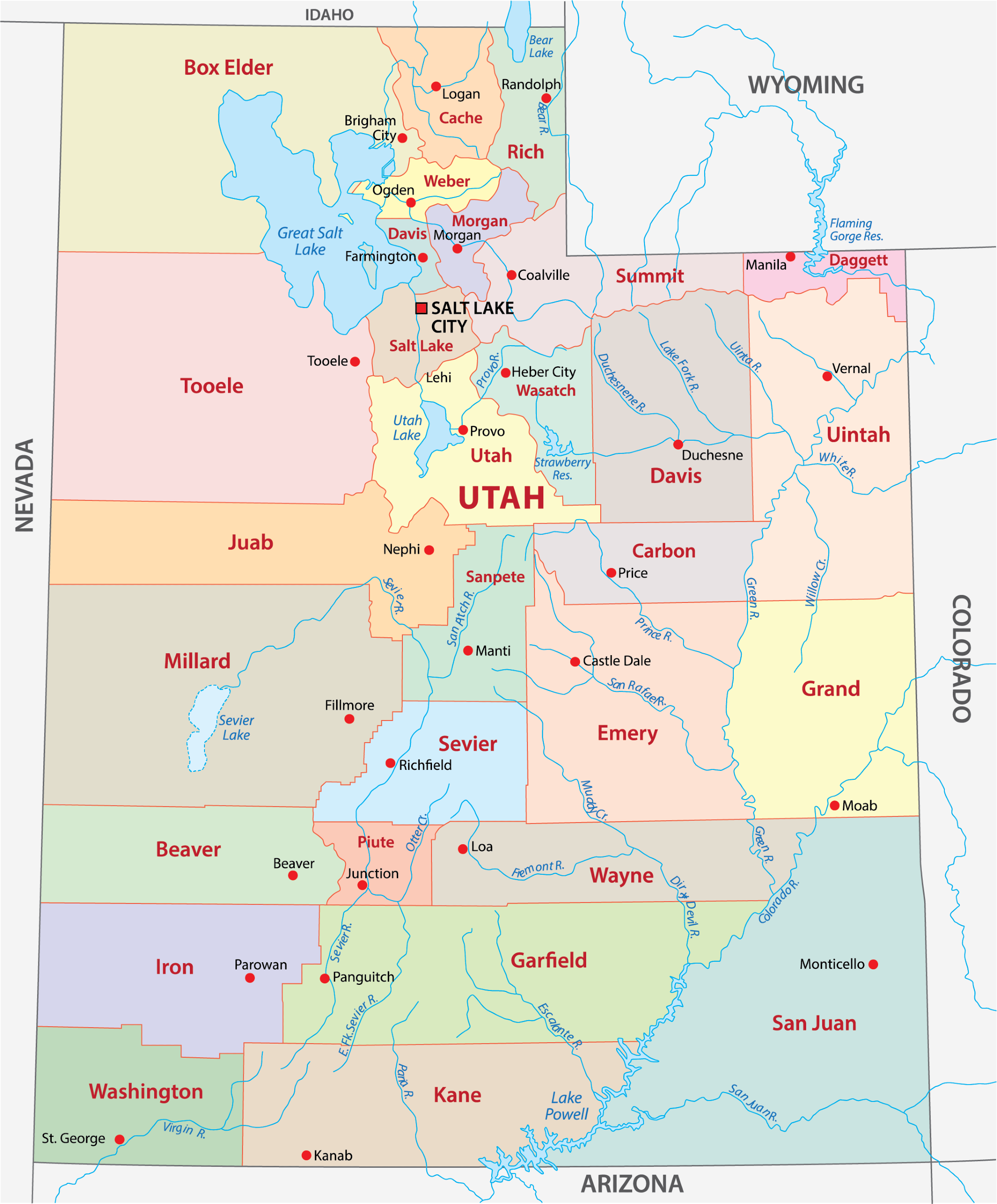
Interactive Map of Utah Counties
Click on any of the counties on the map to see its population, economic data, time zone, and zip code (the data will appear below the map). Data is sourced from the US Census 2021.
List of the Counties of Utah:
| County | Population | Per sq. km | Largest City |
|---|---|---|---|
| Beaver County | 6,962 | 1.04 | Beaver |
| Box Elder County | 56,891 | 3.82 | Brigham City |
| Cache County | 131,703 | 43.66 | Logan |
| Carbon County | 20,208 | 5.27 | Price |
| Daggett County | 564 | 0.31 | Manila |
| Davis County | 358,831 | 463.26 | Layton |
| Duchesne County | 19,651 | 2.35 | Roosevelt |
| Emery County | 9,839 | 0.85 | Huntington |
| Garfield County | 5,061 | 0.38 | Panguitch |
| Grand County | 9,630 | 1.01 | Moab |
| Iron County | 55,839 | 6.54 | Cedar City |
| Juab County | 11,648 | 1.33 | Santaquin |
| Kane County | 7,635 | 0.74 | Kanab |
| Millard County | 12,860 | 0.73 | Delta |
| Morgan County | 12,162 | 7.71 | Morgan |
| Piute County | 1,809 | 0.92 | Circleville |
| Rich County | 2,507 | 0.94 | Randolph |
| Salt Lake County | 1,173,331 | 610.49 | Salt Lake City |
| San Juan County | 14,610 | 0.72 | Blanding |
| Sanpete County | 28,458 | 6.91 | Ephraim |
| Sevier County | 21,471 | 4.34 | Richfield |
| Summit County | 42,156 | 8.7 | Summit Park |
| Tooele County | 71,340 | 3.97 | Tooele |
| Uintah County | 35,488 | 3.06 | Vernal |
| Utah County | 648,265 | 124.89 | Provo |
| Wasatch County | 34,028 | 11.16 | Heber |
| Washington County | 176,533 | 28.08 | St. George |
| Wayne County | 2,500 | 0.39 | Loa |
| Weber County | 259,390 | 173.79 | Ogden |
Biggest Counties in Utah by Population
Salt Lake County

Salt Lake County, established in 1850, is located in the northern part of Utah and is the most populous county in the state. The county seat, Salt Lake City, is known for its historical significance as the heart of the Mormon settlement in Utah, as well as being a modern-day hub for business, culture, and outdoor recreation.
The county is home to the majestic Wasatch Mountains, offering a playground for outdoor enthusiasts with world-class skiing, hiking, and mountain biking. Salt Lake City hosted the 2002 Winter Olympics, further cementing the area’s reputation as a top destination for winter sports.
Cultural highlights include the Utah Museum of Fine Arts and the Natural History Museum of Utah, both located in Salt Lake City, offering insights into regional art and natural sciences. The county also boasts a vibrant music and arts scene, with numerous theaters and galleries, alongside the Utah Symphony Orchestra and the annual Utah Arts Festival.
Utah County

Utah County, established in 1850, is situated in the central part of the state, enveloping Provo, its county seat, and the third-largest city in Utah. This county is a blend of bustling urban centers and breathtaking natural landscapes, including the scenic Provo Canyon and Mount Timpanogos, offering abundant outdoor recreation opportunities such as hiking, skiing, and fishing at Utah Lake.
Provo is known for its strong educational and technological sectors, anchored by Brigham Young University, which significantly influences the area’s culture and economy. The city has become a tech startup hub, earning it the nickname “Silicon Slopes.”
The county celebrates its cultural heritage through events like the annual Freedom Festival, one of the largest Independence Day celebrations in the U.S. Utah County also features the Timpanogos Storytelling Festival, which draws performers and audiences from across the nation, highlighting the area’s commitment to arts and education.
Davis County

Davis County, established in 1850, is located in northern Utah, just north of Salt Lake City, making it part of the Wasatch Front urban corridor. Farmington serves as the county seat, and the county is known for its mix of suburban development and natural beauty.
The Great Salt Lake lies to the west, offering stunning vistas and recreational activities such as sailing and bird watching at the Antelope Island State Park, which is famous for its bison population and hiking trails.
The county plays host to the Lagoon Amusement Park in Farmington, a historic amusement park that has been in operation since 1886, providing entertainment for families with its rides, water park, and pioneer village. Davis County also benefits from its proximity to Salt Lake City, allowing residents easy access to the capital’s cultural and economic opportunities while enjoying a quieter suburban lifestyle.
With a strong emphasis on community and outdoor living, Davis County offers extensive trails and parks, including the Legacy Parkway Trail, which provides miles of scenic biking and walking paths. The county’s economy is diverse, with healthcare, education, and aerospace as significant sectors, highlighted by the presence of Hill Air Force Base, one of the area’s largest employers.
Weber County

Weber County, established in 1850, is located in northern Utah, with Ogden serving as its county seat. Ogden, once a major railway hub, has transformed into a vibrant city known for its historic downtown, outdoor recreation, and growing arts scene. The city’s revitalization is evident along 25th Street, where Victorian buildings now house restaurants, galleries, and boutiques, echoing Ogden’s rich past.
The county is framed by the Wasatch Mountains, offering residents and visitors alike access to world-class skiing, hiking, and mountain biking. Snowbasin and Powder Mountain ski resorts are notable destinations within Weber County, attracting winter sports enthusiasts from around the globe.
Ogden’s Union Station, a symbol of the city’s historical significance in rail travel, now houses museums dedicated to trains, cars, and the cowboy heritage of the West. The Ogden River Parkway and the Ogden Nature Center are examples of the area’s commitment to preserving natural beauty and providing outdoor educational experiences.
Weber State University, located in Ogden, contributes to the county’s educational landscape by offering a wide range of academic programs and cultural events.
Washington County

Washington County, formed in 1852, is located in the southwestern corner of Utah and embodies the scenic beauty and outdoor adventure that the state is known for.
St. George, the county seat, is a fast-growing city that serves as a gateway to Zion National Park, one of Utah’s most visited natural attractions. The park’s towering red cliffs, canyon hikes, and diverse ecosystems draw millions of visitors each year, contributing significantly to the county’s economy.
The area around St. George offers a wealth of recreational opportunities, including golfing on picturesque courses, mountain biking on the extensive network of trails, and exploring the unique landscapes of Snow Canyon State Park. The mild winters and hot summers make Washington County a popular destination for retirees and outdoor enthusiasts alike.
Culturally, St. George hosts events like the St. George Art Festival and performances at the Tuacahn Amphitheatre, set against the backdrop of red rock cliffs. The city’s historic downtown area features buildings from the late 19th century, museums, and art galleries, reflecting the region’s heritage and growing arts scene.
Smallest Counties in Utah by Population
Daggett County

Daggett County, established in 1918, is Utah’s least populous county, nestled in the northeastern corner of the state. It encompasses the small town of Manila, which serves as the county seat.
This remote area is renowned for its stunning natural landscapes, particularly those around Flaming Gorge National Recreation Area. The gorge itself, carved by the Green River and crowned by the Flaming Gorge Dam, is a marvel of natural beauty and engineering, offering unparalleled opportunities for fishing, boating, and camping.
The county’s rugged terrain and vast wilderness areas are a haven for outdoor enthusiasts, with activities ranging from hiking and mountain biking in the summer to snowmobiling and ice fishing in the winter.
The Red Canyon Overlook and the Sheep Creek Geological Loop provide visitors with breathtaking views of the gorge’s dramatic cliffs and diverse wildlife, making Daggett County a unique destination for those looking to explore the less-traveled paths of Utah’s vast wilderness.
Piute County

Piute County, organized in 1869, is tucked away in central Utah, offering a glimpse into the state’s rural heartland. Junction serves as the county seat, embodying the essence of a quiet, small-town atmosphere.
Piute County is rich in natural beauty, with the expansive Fishlake National Forest covering a significant portion of the area. This national forest is home to Fish Lake, the largest natural mountain lake in Utah, renowned for its excellent trout fishing and stunning scenic beauty.
The county is a paradise for outdoor enthusiasts, with the Paiute ATV Trail providing over 2,000 miles of trails that wind through the dense forests and open meadows, offering breathtaking views of the surrounding mountains and valleys.
Wayne County

Wayne County, established in 1892, is nestled in the heart of southern Utah, known for its breathtaking landscapes that encompass a portion of Capitol Reef National Park. The county seat, Loa, encapsulates the serene, rural charm typical of the area, serving as a hub for the surrounding communities.
Capitol Reef National Park, stretching across the eastern part of Wayne County, offers visitors a stunning array of cliffs, canyons, domes, and bridges in the Waterpocket Fold, a geologic monocline extending nearly 100 miles. This national park is a haven for hikers, photographers, and nature lovers drawn to its unique formations and ancient petroglyphs.
Beyond the national park, Wayne County is characterized by its vast expanses of untouched wilderness, including the Dixie National Forest and the Fishlake National Forest, providing ample opportunities for outdoor recreation. The scenic byways and backcountry roads offer access to remote areas, revealing the natural beauty and solitude of Utah’s landscape.
Other Notable Counties in Utah
San Juan County

San Juan County, Utah’s largest county by area, is located in the state’s southeastern corner, offering a diverse and dramatic landscape that ranges from the high peaks of the Abajo and La Sal Mountains to the deep canyons of the Colorado River. The county seat, Monticello, serves as a peaceful residential community, while the larger town of Blanding provides access to a wealth of cultural and historical resources.
The county is renowned for its significant archaeological sites, including Newspaper Rock State Historical Monument, which features a large collection of ancient petroglyphs, and the Edge of the Cedars State Park Museum, home to an extensive collection of Ancestral Puebloan artifacts.
San Juan County’s natural wonders are vast and varied. Monument Valley, with its iconic red sandstone buttes, epitomizes the American West’s rugged beauty and has served as the backdrop for numerous films. The county also encompasses parts of Canyonlands National Park and the Bears Ears National Monument, areas rich in natural beauty and sacred to many Native American tribes.
Cache County

Cache County, formed in 1856, is nestled in the northern region of Utah, with Logan serving as its vibrant county seat. The county is framed by the majestic Bear River Mountains, part of the Wasatch Range, offering breathtaking landscapes and outdoor recreational opportunities, such as hiking, skiing, and camping.
Logan, home to Utah State University, infuses the county with a lively academic and cultural atmosphere, hosting events like the Utah Festival Opera and Musical Theatre, which draws arts enthusiasts from far and wide.
Agriculture plays a significant role in Cache County’s economy, with the surrounding Cache Valley known for its dairy farms and crop production. This agricultural heritage is celebrated annually at the Cache County Fair and Rodeo, an event that showcases the local community’s spirit and traditions.
Cache County also boasts a rich historical heritage, with the American West Heritage Center providing insights into the life of Native Americans, mountain men, pioneers, and farmers through interactive exhibits and living history demonstrations.
Grand County

Grand County, founded in 1890, is located in eastern Utah and is renowned for its stunning landscapes and outdoor recreation opportunities. Moab, the county seat, is a popular base for adventurers drawn to the area’s two iconic national parks: Arches and Canyonlands.
Arches National Park, known for its over 2,000 natural stone arches, including the world-famous Delicate Arch, provides breathtaking vistas and trails suitable for all skill levels. Canyonlands National Park, divided into four districts by the Colorado and Green Rivers, offers a more remote wilderness experience, with stunning overlooks, whitewater rapids, and backcountry trails.
Moab is also a hub for river sports, with the Colorado River offering rafting and kayaking adventures through scenic canyons. The annual Moab Jeep Safari attracts off-road enthusiasts from around the world, eager to tackle the challenging terrain.
Summit County

Summit County, nestled in the northeastern part of Utah, is celebrated for its world-renowned ski resorts and the historic town of Park City.
Established in 1854, Summit County has become synonymous with outdoor winter sports, hosting some of the best skiing and snowboarding facilities in the United States, including Park City Mountain Resort and Deer Valley Resort. These destinations offer miles of meticulously groomed trails and backcountry access for all levels of skiers and snowboarders, set against the backdrop of Utah’s stunning mountain landscapes.
Park City, the county’s most famous town, not only shines as a premier winter sports destination but also as a cultural hub, particularly during the Sundance Film Festival. This annual event transforms the town into a gathering place for filmmakers, celebrities, and film enthusiasts from around the globe, showcasing independent films and fostering discussions on a variety of topics.
In the summer, Summit County’s mountains become a haven for hikers, mountain bikers, and outdoor adventurers seeking to explore the vast trails, scenic alpine lakes, and lush valleys. The county also boasts several golf courses with breathtaking views, making it a year-round destination for sports and outdoor activities.
More About Utah Counties: FAQs
Which county in Utah is home to Zion National Park?
Washington County is home to Zion National Park.
What is the least expensive county in Utah?
Emery County is often considered one of the least expensive counties in Utah in terms of cost of living and real estate.
Which Utah county has the highest Mormon population?
The counties with the highest percentages of Mormon residents in 2018 were Rich, Morgan, and Utah.
What is the newest county in Utah?
Daggett County, established in 1918, is the newest county in Utah.

- Downtown Salt Lake City Skyline at Sunset — © Sean Pavone/Shutterstock
- Aerial View of Downtown Provo, Utah with Mountains in the Background — © Allison H. Smith/Shutterstock
- Serene View of Antelope Island State Park with Reflective Waters and Mountainous Landscape — © Cheri Alguire/Shutterstock
- Vibrant Street Scene with Pedestrians and Storefronts on a Sunny Day — © Heidi Besen/Shutterstock
- Sunset Over Cascading Waterfalls in a Red Rock Desert Landscape — © Mark Bolen/Shutterstock
- Breathtaking View of Flaming Gorge with Snow-Capped Cliffs and Serene River in Utah — © Keith Kogane/Shutterstock
- Scenic View of Otter Creek Reservoir with Boating Activity in Piute County, Utah — © PAK Images/Shutterstock
- Endless Road Through the Red Rock Canyons of Utah — © Sergey Malomuzh/Shutterstock
- Panoramic View of Dead Horse Point State Park with Red Rock Canyons and Distant Snow-Capped Mountains — © Zack Frank/Shutterstock
- Dusk at the Logan Utah LDS Temple with a Vibrant Sunset Sky — © SkyBlodgett/Shutterstock
- Vibrant Sunset at Delicate Arch in Arches National Park — © Josemaria Toscano/Shutterstock
- Aerial View of Park City, Utah at Sunset with Snow-Capped Mountains — © Kevin Ruck/Shutterstock