South Dakota, a state known for its dramatic landscapes, rich history, and vibrant indigenous cultures, is situated in the heart of the Midwestern United States. Its terrain spans from iconic rolling prairies to the majestic Black Hills, offering a glimpse into the natural beauty that defines the Great Plains.
South Dakota is home to renowned monuments such as Mount Rushmore and the Crazy Horse Memorial, reflecting its deep historical significance and the state’s dedication to preserving its heritage.
South Dakota (SD) on the US Map
South Dakota comprises 66 counties, each of which contributes its unique character to the state’s identity. These counties serve as custodians of the state’s natural wonders, historical sites, and cultural festivals. Beginning with a South Dakota Counties Map, we’ll explore some of the most noteworthy counties in the state.
Map of South Dakota Counties
Below is a map of the 66 counties of South Dakota (you can click on the map to enlarge it and to see the major city in each county).
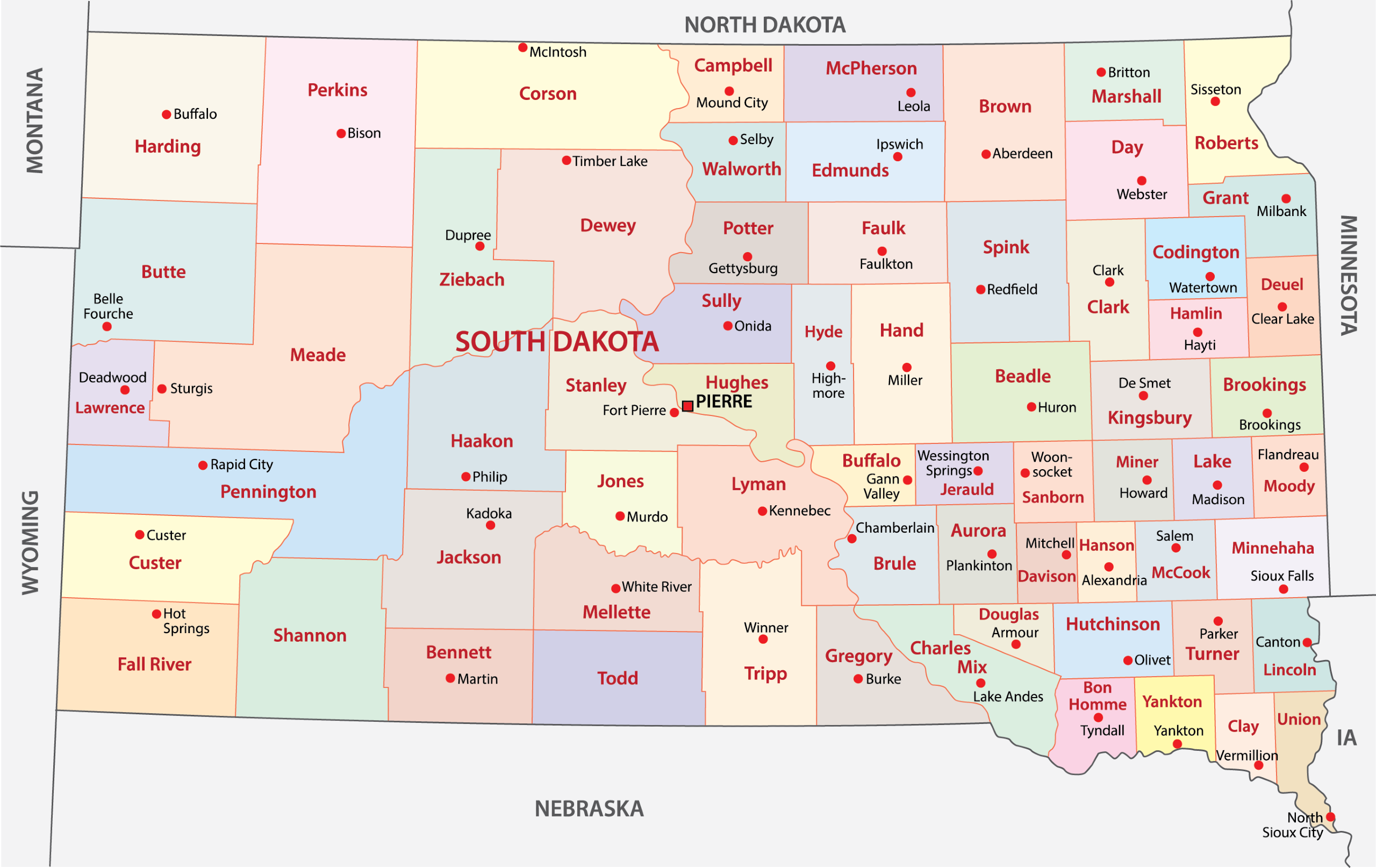
Interactive Map of South Dakota Counties
Click on any of the counties on the map to see its population, economic data, time zone, and zip code (the data will appear below the map). Data is sourced from the US Census 2021.
*The data for Oglala Lakota is currently being updated (previously the county was called Shannon).
List of the Counties of South Dakota:
| County | Population | Per sq. km | Largest City |
|---|---|---|---|
| Aurora County | 2,649 | 1.44 | Plankinton |
| Beadle County | 18,959 | 5.82 | Huron |
| Bennett County | 3,411 | 1.11 | Martin |
| Bon Homme County | 7,020 | 4.81 | Springfield |
| Brookings County | 34,315 | 16.72 | Brookings |
| Brown County | 38,471 | 8.67 | Aberdeen |
| Brule County | 5,247 | 2.48 | Chamberlain |
| Buffalo County | 1,974 | 1.62 | Fort Thompson |
| Butte County | 10,167 | 1.74 | Belle Fourche |
| Campbell County | 1,548 | 0.81 | Herreid |
| Charles Mix County | 9,346 | 3.29 | Wagner |
| Clark County | 3,791 | 1.53 | Clark |
| Clay County | 14,816 | 13.88 | Vermillion |
| Codington County | 28,289 | 15.89 | Watertown |
| Corson County | 3,965 | 0.62 | McLaughlin |
| Custer County | 8,360 | 2.07 | Custer |
| Davison County | 19,944 | 17.68 | Mitchell |
| Day County | 5,487 | 2.06 | Webster |
| Deuel County | 4,283 | 2.66 | Clear Lake |
| Dewey County | 5,343 | 0.9 | North Eagle Butte |
| Douglas County | 2,838 | 2.54 | Armour |
| Edmunds County | 4,005 | 1.37 | Ipswich |
| Fall River County | 6,979 | 1.55 | Hot Springs |
| Faulk County | 2,157 | 0.85 | Faulkton |
| Grant County | 7,550 | 4.28 | Milbank |
| Gregory County | 4,004 | 1.52 | Gregory |
| Haakon County | 1,868 | 0.4 | Philip |
| Hamlin County | 6,127 | 4.67 | Estelline |
| Hand County | 3,061 | 0.82 | Miller |
| Hanson County | 3,429 | 3.05 | Alexandria |
| Harding County | 1,179 | 0.17 | Buffalo |
| Hughes County | 17,829 | 9.28 | Pierre |
| Hutchinson County | 7,412 | 3.52 | Parkston |
| Hyde County | 1,381 | 0.62 | Highmore |
| Jackson County | 2,868 | 0.59 | Wanblee |
| Jerauld County | 1,811 | 1.33 | Wessington Springs |
| Jones County | 916 | 0.36 | Murdo |
| Kingsbury County | 5,131 | 2.38 | De Smet |
| Lake County | 11,358 | 7.79 | Madison |
| Lawrence County | 25,687 | 12.4 | Spearfish |
| Lincoln County | 63,233 | 42.29 | Sioux Falls |
| Lyman County | 3,746 | 0.88 | Lower Brule |
| Marshall County | 4,373 | 2.01 | Britton |
| McCook County | 5,676 | 3.82 | Salem |
| McPherson County | 2,245 | 0.76 | Eureka |
| Meade County | 29,561 | 3.29 | Box Elder |
| Mellette County | 1,916 | 0.57 | White River |
| Miner County | 2,293 | 1.55 | Howard |
| Minnehaha County | 194,884 | 93.26 | Sioux Falls |
| Moody County | 6,335 | 4.71 | Flandreau |
| Oglala Lakota County | 13,835 | 2.55 | Pine Ridge |
| Pennington County | 108,707 | 15.12 | Rapid City |
| Perkins County | 2,977 | 0.4 | Lemmon |
| Potter County | 2,613 | 1.17 | Gettysburg |
| Roberts County | 10,254 | 3.6 | Sisseton |
| Sanborn County | 2,371 | 1.61 | Woonsocket |
| Spink County | 6,408 | 1.65 | Redfield |
| Stanley County | 2,963 | 0.79 | Fort Pierre |
| Sully County | 1,279 | 0.49 | Onida |
| Todd County | 9,434 | 2.62 | Rosebud |
| Tripp County | 5,615 | 1.34 | Winner |
| Turner County | 8,621 | 5.39 | Parker |
| Union County | 16,424 | 13.76 | Dakota Dunes |
| Walworth County | 5,355 | 2.92 | Mobridge |
| Yankton County | 23,213 | 17.2 | Yankton |
| Ziebach County | 2,479 | 0.49 | Eagle Butte |
Biggest Counties in South Dakota by Population
Minnehaha County

Minnehaha County, created in 1862, is the most populous county in South Dakota, with Sioux Falls serving as its county seat and the largest city in the state. Sioux Falls is a regional hub of culture, healthcare, and business, featuring attractions like Falls Park, where the city’s namesake waterfalls cascade through the heart of downtown.
The county is a significant economic center in the region, with a diverse economy that includes healthcare, finance, and manufacturing sectors. Major employers such as Sanford Health and Avera Health, alongside the headquarters of financial companies like Wells Fargo and Citibank, underscore the county’s role in these industries.
Education plays a vital role in Minnehaha County’s community, with multiple school districts and higher education institutions, including Augustana University and the University of Sioux Falls, contributing to the area’s educational landscape.
The Washington Pavilion offers cultural enrichment through its art galleries, science center, and performance spaces, adding to the vibrant community life in Minnehaha County.
Pennington County

Pennington County, formed in 1875, is home to Rapid City, known as the “Gateway to the Black Hills” and the second-largest city in South Dakota. This county is characterized by its stunning landscapes, including the iconic Mount Rushmore National Memorial, which draws visitors from around the globe to witness the monumental carvings of four U.S. presidents.
Beyond Mount Rushmore, Pennington County offers a wealth of natural and cultural attractions. The Badlands National Park, located just to the east, presents a striking landscape of eroded buttes and pinnacles that contrast with the rolling grasslands. Custer State Park, though partly in neighboring Custer County, extends into Pennington and is known for its buffalo herds, scenic drives, and outdoor activities.
Rapid City itself is a vibrant community with a rich arts scene, evidenced by the Art Alley, a constantly evolving public art space, and the Dahl Arts Center, a premier venue for visual and performing arts. The city’s commitment to honoring Native American culture is apparent at the annual Black Hills Powwow, a significant cultural gathering.
Lincoln County

Lincoln County, established in 1867, is among the fastest-growing counties in South Dakota, with Sioux Falls extending into its northern part and serving as a driving force in the county’s development. The county seat, Canton, holds a charm with its historic buildings and community events that reflect the area’s rich heritage.
Significant growth in communities such as Harrisburg and Tea has been propelled by the county’s proximity to Sioux Falls, offering residents a blend of suburban living with easy access to the city’s resources and employment opportunities.
Lincoln County also offers recreational activities with sites like Newton Hills State Park and the Big Sioux River, providing outdoor enthusiasts with places for fishing, hiking, and camping. The county’s agricultural roots are still evident in its rural areas, maintaining a balance between growth and preserving the natural landscape.
Brown County

Brown County, named after legislator Alfred Brown, is located in northeastern South Dakota, with Aberdeen serving as its county seat. Aberdeen, known as the “Hub City” due to its historical significance as a railroad junction, is the primary economic and cultural center of the county.
The city hosts Northern State University, contributing to the vibrant academic and cultural atmosphere with events, educational opportunities, and performances, particularly at the Johnson Fine Arts Center. It also hosts the Dacotah Prairie Museum, which offers insights into the region’s history and culture, showcasing artifacts and exhibits that tell the story of Brown County’s development.
Outdoor recreation in Brown County is facilitated by amenities such as Wylie Park and Richmond Lake Recreation Area, offering activities from camping and fishing to hiking and wildlife viewing. The annual Brown County Fair, held in Aberdeen, is a highlight for residents and visitors, featuring entertainment, agriculture exhibits, and community events that celebrate the county’s heritage and spirit.
Brookings County

Brookings County, established in 1871, is located in eastern South Dakota, with the city of Brookings serving as the county seat. Brookings is known for being an educational and cultural hub in the region, primarily due to South Dakota State University (SDSU), the state’s largest institution of higher education.
The South Dakota Art Museum, located on the SDSU campus, houses an extensive collection of regional art, including works by Harvey Dunn and Oscar Howe. The museum plays a crucial role in the cultural life of Brookings County, offering exhibitions and educational programs that enrich the community.
Agriculture remains a vital part of Brookings County’s economy, with the university’s research farms and the annual Brookings Summer Arts Festival highlighting the county’s agricultural heritage and arts scene. The McCrory Gardens, also part of SDSU, is a botanical garden and arboretum that offers a peaceful retreat with its beautiful plant collections and landscapes.
Smallest Counties in South Dakota by Population
Jones County

Jones County, established in 1916, is located in central South Dakota and is the least populous county in the state. Murdo, the county seat, encapsulates the essence of a small Midwestern town, offering a glimpse into rural American life.
Despite its modest size, Murdo attracts visitors with attractions like the Pioneer Auto Museum, which features a vast collection of classic cars, motorcycles, and Americana memorabilia, showcasing the nation’s automotive history and heritage.
The landscape of Jones County is marked by rolling plains and wide-open spaces, providing habitat for wildlife and opportunities for outdoor activities such as hunting and bird watching. The county’s community is tightly knit, hosting events like the annual Jones County Invitational Basketball Tournament.
Harding County

Harding County, formed in 1909, is located in the northwestern corner of South Dakota, bordering both Montana and North Dakota. As one of the least populous counties in the state, Harding County offers a vast expanse of natural beauty and rugged landscapes, including the picturesque Slim Buttes, which are rich in history and offer spectacular hiking.
Harding County is also known for its rich paleontological sites, attracting scientists and enthusiasts to explore its fossil-rich areas. The county’s remote and pristine environment supports a wide variety of wildlife, making it a popular destination for hunting, particularly for species such as mule deer and antelope.
Community events, such as the annual Harding County Fair, bring residents together for rodeo events, livestock shows, and family entertainment, showcasing the close-knit nature of the community and its deep-rooted connection to the land.
Sully County

Sully County, established in 1873, is nestled in central South Dakota, featuring the Missouri River as a defining natural landmark that enhances the county’s scenic beauty and recreational opportunities. Onida, the county seat, embodies the spirit of small-town life while serving as the agricultural and administrative center of the county.
The presence of the Missouri River contributes to Sully County’s reputation as a prime location for fishing, boating, and water sports, with Lake Oahe providing abundant opportunities for walleye fishing and camping along its shores. This vast reservoir is a draw for anglers and outdoor enthusiasts from across the region, offering some of the best fishing experiences in the state.
Agriculture remains a cornerstone of the county’s economy, with the fertile lands along the river supporting a variety of crops and livestock. The annual Sully County Fair in Onida is a highlight for the community, featuring rodeo events, agricultural exhibits, and family entertainment.
Other Notable South Dakota Counties
Meade County

Meade County, established in 1889, is one of South Dakota’s largest counties by area and encompasses a diverse range of landscapes, including parts of the Black Hills and the prairies of the Great Plains. Sturgis, the county seat, is internationally recognized for hosting the Sturgis Motorcycle Rally every August, drawing motorcycle enthusiasts from around the globe for a week of events, concerts, and camaraderie.
The county also holds significant historical and natural attractions. Bear Butte State Park, located just northeast of Sturgis, is a sacred site for many Native American tribes and offers hiking trails that lead to panoramic views of the surrounding landscape. The park is an important cultural and spiritual site, providing visitors with insights into the area’s indigenous heritage.
Besides its motorcycle fame and natural beauty, Meade County is home to Ellsworth Air Force Base, a key military installation near Box Elder. The base plays a significant role in the local economy and community, adding to the county’s strategic importance.
Lawrence County

Lawrence County, organized in 1877, is located in the northern Black Hills of South Dakota. The county seat, Deadwood, is famed for its rich Wild West history, having been a bustling mining town during the Black Hills Gold Rush.
Today, Deadwood is a National Historic Landmark District, where visitors can walk cobblestone streets, explore historic buildings, and learn about figures like Wild Bill Hickok and Calamity Jane who roamed its streets.
In addition to its historical attractions, Deadwood offers gaming and entertainment, with numerous casinos and yearly events that celebrate its gold rush heritage. Lawrence County is also known for Spearfish Canyon, a deep and scenic limestone canyon rich in wildlife, waterfalls, and hiking trails, offering breathtaking views and outdoor activities throughout the year.
The city of Spearfish, another significant community within Lawrence County, hosts Black Hills State University, contributing to the area’s educational and cultural landscape. The university brings a youthful energy to the region, along with cultural amenities like the Matthews Opera House & Arts Center.
Custer County

Custer County, named after the famous Lt. Colonel George Armstrong Custer, was established in 1875 and is situated in the southwestern part of South Dakota, within the Black Hills National Forest.
Custer, the county seat, is a gateway to some of the state’s most significant natural attractions, including Custer State Park, renowned for its wildlife, scenic drives like the Needles Highway, and Sylvan Lake, known for its stunning beauty and outdoor recreational opportunities.
This county is also home to the Crazy Horse Memorial, an ongoing mountain carving project dedicated to the Native American warrior, Crazy Horse, symbolizing the culture, tradition, and living heritage of North American Indians. Nearby, the Jewel Cave National Monument, one of the longest caves in the world, offers guided tours through its fascinating underground chambers.
Fall River County

Fall River County, established in 1883, is located in the southern part of South Dakota and is distinguished by its unique geological features and therapeutic hot springs. The county seat, Hot Springs, is renowned for its warm mineral springs that have attracted visitors seeking relaxation and healing for over a century.
Hot Springs is also home to the Evans Plunge, the oldest mineral spring pool in the Black Hills, and the Mammoth Site, an active paleontological excavation site where over 60 mammoths have been discovered, making it the world’s largest mammoth research facility.
Adjacent to Hot Springs is the Wind Cave National Park, one of the oldest national parks in the U.S., featuring one of the world’s longest and most complex cave systems. Above ground, the park’s mixed-grass prairie and ponderosa pine forests are home to diverse wildlife, including bison, elk, and pronghorns.
Fall River County’s landscape offers a blend of natural beauty and recreational activities. Angostura Recreation Area, with its large reservoir, provides opportunities for boating, fishing, and swimming, while the county’s location in the Black Hills offers access to miles of hiking and biking trails.
Hughes County

Hughes County, organized in 1880, is centrally located in South Dakota and serves as the state’s political hub, with Pierre, the state capital, as its county seat. Pierre stands on the banks of the Missouri River, which plays a central role in the county’s geography and recreation.
The river provides ample opportunities for fishing, boating, and waterside activities, particularly at the Farm Island Recreation Area, which offers trails, beaches, and wildlife viewing.
The South Dakota State Capitol building, with its distinctive architecture and beautiful grounds, including a walking trail that details the state’s history, is a focal point of Hughes County. The Capitol complex and nearby Cultural Heritage Center serve as resources for learning about South Dakota’s legislative and cultural past.
Additionally, the Oahe Dam, just north of Pierre, creates one of the largest man-made reservoirs in the country, Lake Oahe, extending from central South Dakota into North Dakota.
More About South Dakota Counties: FAQs
Which South Dakota county is the largest by area?
Meade County is the largest by area in South Dakota, covering 3,471 sq mi (8,990 km2).
Which county in South Dakota is the most affordable?
Oglala Lakota County has one of the lowest costs of living in South Dakota.
What county in South Dakota has the youngest population?
Brookings County, due in part to the student population at South Dakota State University, tends to have one of the youngest populations in the state.
What South Dakota County has the largest Native American population?
Oglala Lakota County, located within the Pine Ridge Indian Reservation, has the highest Native American population in South Dakota, predominantly consisting of Oglala Sioux Tribe members.

- Aerial View of Sioux Falls, South Dakota at Sunset — © Jacob Boomsma/Shutterstock
- Mount Rushmore National Memorial: Iconic Stone Carvings of U.S. Presidents — © Mendenhall Olga/Shutterstock
- Aerial View of a Small Town with Agricultural Silos and Train Tracks — © Jacob Boomsma/Shutterstock
- Aerial View of a Snow-Dusted Town with Sparse Vegetation and Overcast Skies — © Jacob Boomsma/Shutterstock
- Classic Brick Building with Landscaped Front Lawn on a Clear Day — © Ken Wolter/Shutterstock
- Serene Country Church Under a Blue Sky with Fluffy Clouds — © Nagel Photography/Shutterstock
- Golden Valley 1921 Norwegian Lutheran Church in Harding County at Dusk — © Justinebelden/Wikimedia Commons
- Rolling Hills and Sparse Greenery Under a Cloudy Sky — © Michael J Magee/Shutterstock
- Bustling Main Street Scene with Motorcycles Lined Up in Sturgis, South Dakota During a Sunny Day — © Photostravellers/Shutterstock
- Aerial View of a Snow-Covered Town with Historic Buildings — © Jacob Boomsma/Shutterstock
- American Bison Herd Grazing in Custer County Landscape — © turtix/Shutterstock
- Mammoth Skeleton on Display at a Museum Exhibit — © Jacob Boomsma/Shutterstock
- South Dakota State Capitol Building with American Flag — © Nagel Photography/Shutterstock