Located in the Western United States, Nevada is often celebrated for its vast deserts, vibrant cities, and rich history. Known primarily for Las Vegas, the entertainment capital of the world, Nevada also boasts a legacy of silver mining, stunning natural landscapes like the Sierra Nevada mountains, and a key role in the development of the American West.
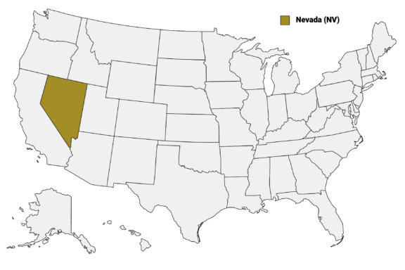
Nevada (NV) on the US Map
Nevada is composed of 16 counties and Carson City, the state capital. From the bustling streets of Clark County’s Las Vegas to the historical mining towns in Esmeralda, this post will explore the most interesting counties in Nevada.
Below is a Nevada Counties Map that details the borders of each county in the state and provides extra information about their populations and biggest cities.
Map of Nevada Counties
Below is a map of the 16 counties of Nevada (you can click on the map to enlarge it and to see the major city in each county).
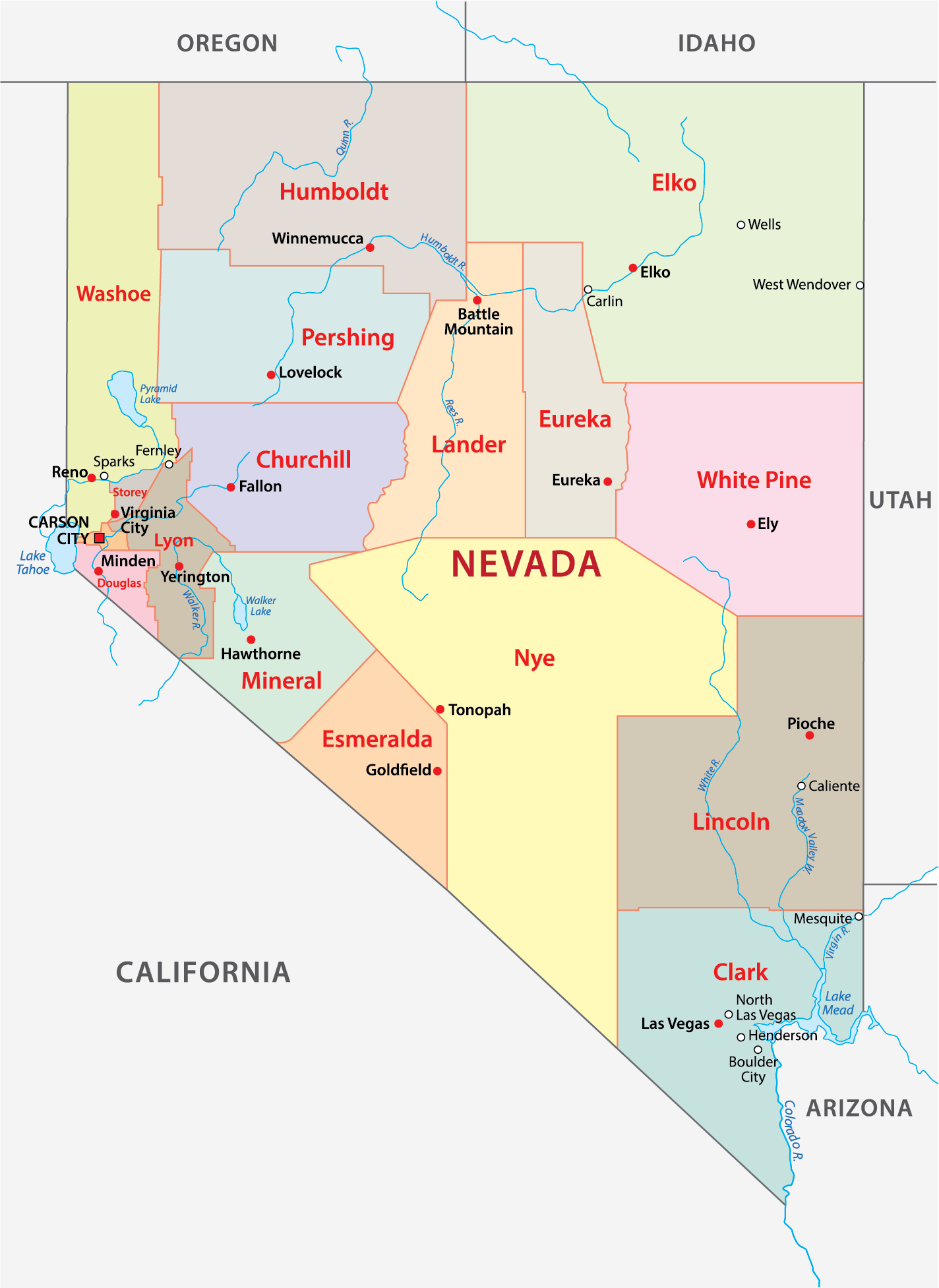
Interactive Map of Nevada Counties
Click on any of the counties on the map to see its population, economic data, time zone, and zip code (the data will appear below the map). Data is sourced from the US Census 2021.
List of the Counties of Nevada:
| County | Population | Per sq. km | Largest City |
|---|---|---|---|
| Carson City | 57,957 | 154.82 | Carson City |
| Churchill County | 25,077 | 1.96 | Fallon |
| Clark County | 2,231,147 | 109.16 | Las Vegas |
| Douglas County | 49,158 | 26.71 | Gardnerville Ranchos |
| Elko County | 53,420 | 1.2 | Elko |
| Esmeralda County | 987 | 0.11 | Dyer |
| Eureka County | 1,603 | 0.15 | Crescent Valley |
| Humboldt County | 17,218 | 0.69 | Winnemucca |
| Lander County | 5,729 | 0.4 | Battle Mountain |
| Lincoln County | 4,600 | 0.17 | Pioche |
| Lyon County | 58,029 | 11.19 | Fernley |
| Mineral County | 4,552 | 0.47 | Hawthorne |
| Nye County | 50,096 | 1.06 | Pahrump |
| Pershing County | 6,668 | 0.43 | Lovelock |
| Storey County | 4,047 | 5.92 | Virginia City |
| Washoe County | 479,758 | 29.33 | Reno |
| White Pine County | 9,192 | 0.4 | Ely |
Biggest Counties in Nevada by Population
Clark County

Clark County, the engine of Nevada’s growth, was established in 1909 and is by far the state’s most populous region. It is home to Las Vegas, the vibrant city known worldwide for its bustling Strip, with its 24-hour casinos, endless entertainment options, and high-profile resort properties.
Las Vegas, the county seat, is more than just a tourist destination; it’s a metropolitan area with a diverse population and a growing economy encompassing sectors like technology and renewable energy. Beyond the neon lights, Clark County offers outdoor adventures at places like the Red Rock Canyon National Conservation Area and Lake Mead.
The county’s history is deeply rooted in the construction of the Hoover Dam, an engineering marvel of the Great Depression era. Clark County’s culture and history are on display at venues like the Neon Museum and the Bellagio Gallery of Fine Art.
Washoe County

Washoe County, created in 1861, is Nevada’s second most populous county, with Reno as its county seat. Known as “The Biggest Little City in the World,” Reno offers a blend of gaming, outdoor recreation, and cultural events. The city is also a growing tech hub, with an expanding economy beyond the casino and tourism sectors.
The county is home to the Nevada Museum of Art, a notable cultural institution recognized for its dynamic exhibition programming and focus on environmental sustainability. Reno’s annual events, like the Reno Balloon Race and the Reno Rodeo, draw crowds for their colorful displays and Western heritage.
Washoe County’s landscape is diverse, featuring parts of the Sierra Nevada mountain range and Lake Tahoe, one of the country’s largest alpine lakes known for its clear waters and ski resorts. The University of Nevada, Reno adds a lively educational and research atmosphere to the county, fostering innovation and development.
Lyon County

Lyon County, one of Nevada’s original nine counties formed in 1861, is known for its rich mining history and agricultural contributions. Yerington, the county seat, sits amidst the fertile Mason Valley, an oasis of agricultural activity within the arid Great Basin region.
This county’s roots run deep with mining activities, notably in the historic Comstock Lode, which played a crucial role during the silver boom in the 19th century. Today, the remnants of this era can be explored in places like the Lyon County Museum in Yerington, which showcases local history.
Outdoor recreation in Lyon County is plentiful, with the Walker River providing excellent opportunities for fishing, camping, and boating. The county also includes part of the expansive Lake Lahontan, offering additional recreational activities and drawing visitors for its natural beauty and wildlife.
Carson City

Carson City, officially the Consolidated Municipality of Carson City and not designated as a county, functions as an independent city and the capital of Nevada. Established in 1858 and named after the famous frontiersman and guide Kit Carson, it became the capital in 1864 when Nevada was admitted as a state.
Carson City boasts a wealth of historical significance, exemplified by the Nevada State Museum, which is housed in a former U.S. Mint building and features exhibits on the state’s natural and cultural history. The Nevada State Railroad Museum also attracts history enthusiasts, showcasing the rich railroad heritage of the state.
With the Sierra Nevada mountains providing a scenic backdrop, Carson City offers a blend of cultural sites, such as the historic Nevada State Capitol building, and outdoor activities, with nearby Lake Tahoe offering year-round recreation.
Elko County

Elko County, established in 1869, stretches across the northeastern corner of Nevada, embodying the spirit of the American West. Elko, the county seat, is a true cowboy town, annually hosting the National Cowboy Poetry Gathering, an event celebrating the ranching and cowboy lifestyle through poetry, music, and storytelling.
The region is known for its gold mining, with significant operations contributing to Nevada’s ranking as one of the top gold-producing areas in the world. The California Trail Interpretive Center offers insights into the pioneer experience and the trails that brought settlers westward during the Gold Rush era.
Elko County’s rugged terrain provides abundant opportunities for outdoor adventures, from hunting and fishing in the Ruby Mountains to exploring the vast wilderness of the high desert.
What is now Elko County was home to the Western Shoshone Indians for thousands of years before European immigrants arrived. The county is now home to the Elko Colony reservation.
Smallest Counties in Nevada by Population
Esmerelda County

Esmeralda County, established in 1861, is the least populous county in Nevada, offering a glimpse into the state’s historic mining past. Named after the Spanish word for “emerald,” a nod to the rich mineral deposits in the area, the county seat is Goldfield, once a booming mining town during the early 20th-century gold rush.
Today, Goldfield is a living ghost town, retaining its historical charm with sites like the Goldfield Hotel and the historic courthouse, reflecting the county’s vibrant heyday. The remnants of mines and the rugged landscape tell the story of a time when the area buzzed with prospectors and fortune seekers.
Eureka County

Eureka County, established in 1873, is a quintessential example of Nevada’s mining heritage. Its county seat, Eureka, known as “The Friendliest Town on the Loneliest Road,” reflects the county’s rich history in silver and lead mining, which peaked in the late 19th century.
The town of Eureka retains much of its historical architecture, with well-preserved buildings such as the Eureka Opera House and the Eureka Sentinel Museum, the latter housed in a building that once printed a mining town newspaper. These landmarks offer a window into the life of a booming mining community of the past.
In addition to its historical significance, Eureka County is characterized by its vast open landscapes and outdoor recreational opportunities. The region’s rugged beauty and open spaces make it a destination for those seeking a connection with Nevada’s natural environment and mining past.
Storey County

Storey County, established in 1861 and named after Captain Edward Farris Storey, a Civil War hero, is a notable region in Nevada, steeped in the state’s mining history. The county seat, Virginia City, once the heart of the Comstock Lode, played a pivotal role in Nevada’s mining boom in the 19th century.
Today, Virginia City is a well-preserved example of a Wild West boomtown, attracting visitors with its authentic historic buildings, wooden sidewalks, and old-time saloons. The city is a living museum, offering a vivid glimpse into the life of a mining town, complete with historical tours, museums, and reenactments.
Storey County, though small in population, is significant for its impact on Nevada’s early economic development. It also hosts events like the annual Virginia City Hill Climb and the Chili on the Comstock cookoff.
Most Notable Counties in Nevada
Nye County

Nye County, the third-largest county in the United States by area, was established in 1864 and named after James W. Nye, a senator and the first Governor of the Nevada Territory.
The county is known for its vast, open landscapes and a history intertwined with nuclear testing, as it is home to the Nevada Test Site, a key location for nuclear testing during the Cold War era.
The county seat, Tonopah, once a booming silver mining town, now attracts visitors with its historic mining parks and the Tonopah Historic Mining Park. Nye County also encompasses a portion of Death Valley National Park, recognized for its extreme desert environment and striking geological features.
In addition to its historical and geological significance, Nye County has become known for its involvement in the aerospace industry and renewable energy projects.
Lander County

Lander County, established in 1862, is nestled in the heart of Nevada and named after Frederick W. Lander, a chief engineer of the federal wagon route through the territory. The county seat, Battle Mountain, epitomizes the region’s enduring legacy in gold mining, contributing significantly to Nevada’s reputation as a major gold-producing area.
Battle Mountain and the surrounding areas in Lander County have a rich history of mining that dates back to the 19th century, with ongoing operations reflecting the area’s continued importance in the mining sector. The county’s landscape is marked by striking desert scenery and rugged mountains, offering outdoor activities like hiking and off-road exploration.
Lander County’s cultural heritage is celebrated through events like the annual Chukar Tournament, reflecting the local community’s connection to the land and wildlife.
Churchill County

Churchill County, established in 1861, is located in western Nevada and is known for its agricultural and military significance. The county seat, Fallon, is home to the Naval Air Station Fallon, a premier site for naval aviation training and the only facility where entire carrier air wings can conduct comprehensive training.
Agriculture plays a pivotal role in Churchill County, particularly due to the Newlands Irrigation Project, one of the first federal irrigation projects in the United States. This project transformed the area into a productive agricultural region, especially known for its alfalfa and cantaloupe farming.
Fallon itself offers a blend of small-town charm and key amenities, with attractions like the Fallon Cantaloupe Festival and Country Fair celebrating the county’s agricultural heritage. Additionally, the county’s location near the Lahontan Reservoir provides opportunities for fishing, boating, and bird watching.
Pershing County

Pershing County, created in 1919 and named after General John J. Pershing, is situated in northwestern Nevada. The county seat, Lovelock, is a small town known for its unique round courthouse, one of only two in the United States.
The county is perhaps most famously known for the annual Burning Man festival, held in the Black Rock Desert. This event attracts thousands from around the globe for its celebration of art, self-expression, and community. The stark, expansive playa of the Black Rock Desert provides a dramatic backdrop for this unique cultural phenomenon.
Pershing County also has a history rooted in mining and ranching, with these industries still playing a role in the local economy. The landscape, characterized by vast open spaces and desert terrain, offers outdoor activities such as hiking and rock hounding, appealing to adventurers and nature lovers.
Humboldt County

Humboldt County, named after the Humboldt River which traverses it, was established in 1856, making it the oldest county in Nevada.
The county seat, Winnemucca, embodies the spirit of the American West with its rich ranching and cowboy culture. The city is a central point for events that celebrate this heritage, including the popular Winnemucca Ranch Hand Rodeo.
The county is not only a hub for ranching but also for mining, with various operations extracting precious minerals. Humboldt County’s vast and varied landscape includes parts of the stunning Santa Rosa Range, offering outdoor activities like hiking, hunting, and fishing.
Winnemucca’s location on Interstate 80 makes it a convenient stop for travelers, with local attractions such as the Humboldt Museum providing insights into the region’s history and natural environment.
More About Counties in Nevada: FAQs
What is the oldest town in Nevada?
Genoa, in Douglas County, is considered the oldest permanent settlement in Nevada, established in 1851.
What county in Nevada has the highest population density?
Clark County has the highest population density in Nevada, largely due to the city of Las Vegas.
Which of Nevada’s counties have ghost towns?
Nevada is famous for ghost towns, especially in counties like Esmerelda and Nye, remnants of the mining boom era.
Which county in Nevada has the youngest population?
Clark County tends to have the youngest population overall due to the urban and metropolitan nature of Las Vegas. The city attracts a younger demographic with its job opportunities, entertainment options, and lifestyle.
Which Nevada county is the largest producer of gold?
Lander County is one of the leading gold-producing counties in Nevada and contributes significantly to the state’s mining industry.

- Aerial View of the Las Vegas Strip at Dusk — © vichie81/Shutterstock
- Dusk View of the Iconic Reno Arch with Illuminated Signage in Reno, Nevada — © Allard One/Shutterstock
- Tranquil Landscape of the Remnants of Pleistocene Lake Lahontan in Lyon County — © Dominic Gentilcore PhD/Shutterstock
- Entrance to the Governor’s Mansion with Landscaped Garden at Dusk — © Nagel Photography/Shutterstock
- Serene Morning at Liberty Lake in Elko County with Wildflowers in Foreground — © Kit Leong/Shutterstock
- Artistic Car Installation in a Desert Landscape — © pmvfoto/Shutterstock
- Aerial View of a Small Town in Eureka County, Nevada — © Jacob Boomsma/Shutterstock
- Historic Main Street in a Small American Town with Vintage Architecture — © Pandora Pictures/Shutterstock
- Vintage Charm of Tonopah: The Historic Mizpah Hotel and Classic A&W Restaurant on a Sunny Day — © travelview/Shutterstock
- Serene Hot Springs with Snow-Capped Mountains in the Background — © Dominic Gentilcore PhD/Shutterstock
- Rodeo Riders in Action at Churchill County Fairgrounds — © TLF Images/Shutterstock
- Abandoned Brick Building in the Nevada Desert at Sunset — © Neil Lockhart/Shutterstock
- Dramatic Sunset Skies Over Humboldt County, Nevada — © Widmer Works/Shutterstock