Lakes, hockey, and the Mall of America might be the first things Minnesota brings to mind, but there’s much more to this state in the American Midwest.
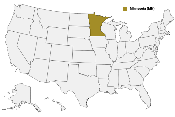
Minnesota (MN) on the US Map
There are 87 counties in Minnesota, each with its own history, landmarks, and culture.
In this post, we’ll share our detailed Minnesota Counties Map, which details the borders and major cities in each of Minnesota’s counties. We’ll also take a look at some of the most notable counties in the state, starting with the most populous.
Map of Minnesota Counties
Below is a map of the 87 counties of Minnesota (you can click on the map to enlarge it and to see the major city in each county).
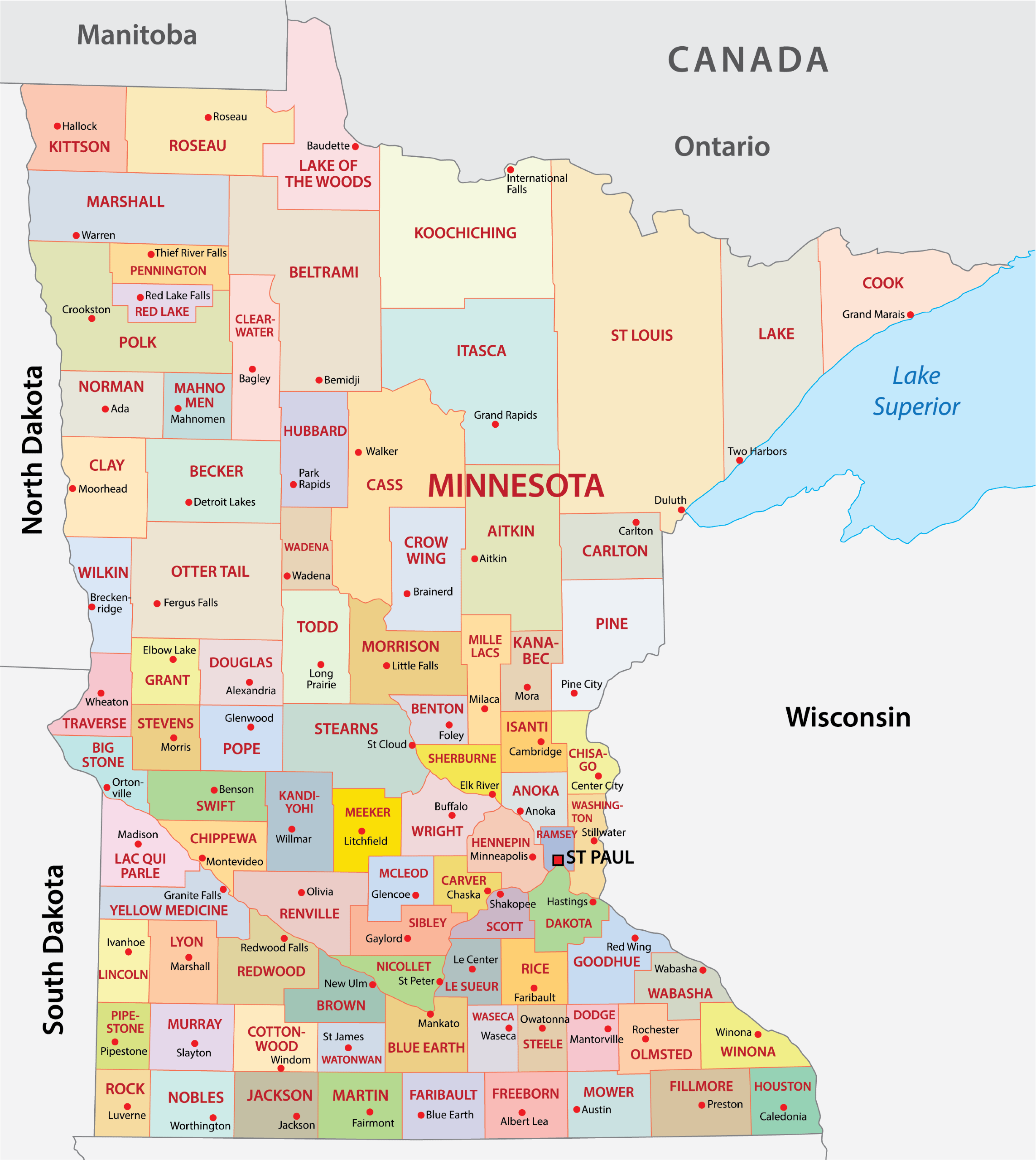
Interactive Map of Minnesota Counties
Click on any of the counties on the map to see its population, economic data, time zone, and zip code (the data will appear below the map). Data is sourced from the US Census 2021.
List of the Counties of Minnesota:
| County | Population | Per sq. km | Largest City |
|---|---|---|---|
| Aitkin County | 15,747 | 3.34 | Aitkin |
| Anoka County | 360,773 | 330.11 | Blaine |
| Becker County | 34,995 | 10.27 | Detroit Lakes |
| Beltrami County | 46,033 | 7.1 | Bemidji |
| Benton County | 41,087 | 38.85 | St. Cloud |
| Big Stone County | 5,155 | 3.99 | Ortonville |
| Blue Earth County | 68,575 | 35.4 | Mankato |
| Brown County | 25,894 | 16.36 | New Ulm |
| Carlton County | 36,145 | 16.21 | Cloquet |
| Carver County | 105,694 | 115.27 | Chaska |
| Cass County | 29,917 | 5.71 | Lake Shore |
| Chippewa County | 12,509 | 8.31 | Montevideo |
| Chisago County | 56,328 | 52.42 | North Branch |
| Clay County | 64,975 | 24 | Moorhead |
| Clearwater County | 8,525 | 3.3 | Bagley |
| Cook County | 5,574 | 1.48 | Grand Marais |
| Cottonwood County | 11,484 | 6.93 | Windom |
| Crow Wing County | 65,879 | 25.48 | Brainerd |
| Dakota County | 435,863 | 299.15 | Lakeville |
| Dodge County | 20,798 | 18.28 | Kasson |
| Douglas County | 38,742 | 23.48 | Alexandria |
| Faribault County | 13,933 | 7.55 | Blue Earth |
| Fillmore County | 21,179 | 9.49 | Chatfield |
| Freeborn County | 30,882 | 16.86 | Albert Lea |
| Goodhue County | 47,503 | 24.24 | Red Wing |
| Grant County | 6,045 | 4.26 | Elbow Lake |
| Hennepin County | 1,270,283 | 885.25 | Minneapolis |
| Houston County | 18,806 | 13.15 | La Crescent |
| Hubbard County | 21,219 | 8.85 | Park Rapids |
| Isanti County | 40,604 | 35.98 | Cambridge |
| Itasca County | 44,969 | 6.51 | Grand Rapids |
| Jackson County | 10,016 | 5.5 | Jackson |
| Kanabec County | 16,004 | 11.85 | Mora |
| Kandiyohi County | 43,504 | 21.07 | Willmar |
| Kittson County | 4,213 | 1.48 | Hallock |
| Koochiching County | 12,203 | 1.52 | International Falls |
| Lac qui Parle County | 6,753 | 3.41 | Madison |
| Lake County | 10,835 | 1.98 | Two Harbors |
| Lake of the Woods County | 3,757 | 1.12 | Baudette |
| Le Sueur County | 28,567 | 24.58 | Mankato |
| Lincoln County | 5,655 | 4.07 | Tyler |
| Lyon County | 25,477 | 13.77 | Marshall |
| Mahnomen County | 5,429 | 3.76 | Mahnomen |
| Marshall County | 9,082 | 1.98 | Warren |
| Martin County | 20,070 | 10.88 | Fairmont |
| McLeod County | 36,662 | 28.8 | Hutchinson |
| Meeker County | 23,268 | 14.78 | Litchfield |
| Mille Lacs County | 26,397 | 17.81 | Princeton |
| Morrison County | 33,876 | 11.63 | Little Falls |
| Mower County | 39,985 | 21.71 | Austin |
| Murray County | 8,224 | 4.51 | Slayton |
| Nicollet County | 34,295 | 29.52 | Mankato |
| Nobles County | 22,223 | 12 | Worthington |
| Norman County | 6,500 | 2.88 | Ada |
| Olmsted County | 160,928 | 95.08 | Rochester |
| Otter Tail County | 59,728 | 11.7 | Fergus Falls |
| Pennington County | 14,063 | 8.81 | Thief River Falls |
| Pine County | 28,997 | 7.93 | Pine City |
| Pipestone County | 9,370 | 7.78 | Pipestone |
| Polk County | 31,303 | 6.13 | East Grand Forks |
| Pope County | 11,216 | 6.47 | Glenwood |
| Ramsey County | 549,377 | 1393.21 | St. Paul |
| Red Lake County | 3,921 | 3.5 | Red Lake Falls |
| Redwood County | 15,435 | 6.78 | Redwood Falls |
| Renville County | 14,768 | 5.8 | Olivia |
| Rice County | 66,795 | 52.01 | Faribault |
| Rock County | 9,718 | 7.78 | Luverne |
| Roseau County | 15,321 | 3.54 | Roseau |
| Scott County | 149,568 | 162.09 | Shakopee |
| Sherburne County | 96,295 | 85.88 | St. Cloud |
| Sibley County | 14,948 | 9.8 | Le Sueur |
| St. Louis County | 200,311 | 12.38 | Duluth |
| Stearns County | 157,638 | 45.33 | St. Cloud |
| Steele County | 37,363 | 33.58 | Owatonna |
| Stevens County | 9,669 | 6.62 | Morris |
| Swift County | 9,810 | 5.1 | Benson |
| Todd County | 25,121 | 10.26 | Long Prairie |
| Traverse County | 3,362 | 2.26 | Wheaton |
| Wabasha County | 21,425 | 15.82 | Lake City |
| Wadena County | 14,009 | 10.08 | Wadena |
| Waseca County | 18,972 | 17.3 | Waseca |
| Washington County | 264,818 | 265.77 | Woodbury |
| Watonwan County | 11,223 | 9.96 | St. James |
| Wilkin County | 6,495 | 3.34 | Breckenridge |
| Winona County | 49,889 | 30.76 | Winona |
| Wright County | 139,890 | 81.69 | Otsego |
| Yellow Medicine County | 9,616 | 4.89 | Granite Falls |
Largest Counties in Minnesota by Population
Hennepin County

Hennepin County, established in 1852, is the most populous county in Minnesota, anchored by Minneapolis, its largest city and county seat. The county was named after Louis Hennepin, a 17th-century explorer who first documented the Falls of Saint Anthony.
Located in east-central Minnesota, Hennepin County plays a pivotal role in the state’s economy and culture. Minneapolis, known as the “City of Lakes,” boasts a rich cultural scene with institutions like the Walker Art Center and the Minneapolis Institute of Art. The city is also a major business center, home to several Fortune 500 companies.
Hennepin County is recognized for its extensive park system, offering abundant green spaces and recreational opportunities in urban settings. The county’s geography is characterized by its lakes, rivers, and the scenic Minnehaha Falls.
Education is a cornerstone of the county, highlighted by the presence of the University of Minnesota in Minneapolis.
Ramsey County

Ramsey County, the smallest yet second most populous county in Minnesota, was established in 1849. It is named after Alexander Ramsey, the first governor of the Minnesota Territory. The county seat, Saint Paul, is also the state capital and forms the “Twin Cities” metropolitan area with neighboring Minneapolis.
Situated in the southeast part of the state, Ramsey County plays a crucial role in Minnesota’s government and politics. Saint Paul is known for its well-preserved Victorian-era architecture, with landmarks like the James J. Hill House and the Saint Paul Cathedral.
The county is also a cultural hub, home to institutions such as the Minnesota History Center and the Science Museum of Minnesota. The vibrant arts scene is epitomized by the annual Saint Paul Winter Carnival, a tradition dating back to 1886.
Ramsey County’s extensive parks and open spaces, like Como Park and the Bruce Vento Nature Sanctuary, provide residents with urban green spaces.
Dakota County

Dakota County, established in 1849, is one of the seven counties in the Minneapolis-Saint Paul metropolitan area. Named after the Dakota Sioux tribal bands who inhabited the area, it’s the third-most populous county in Minnesota. The county seat is Hastings, known for its historic architecture and the iconic Hastings Spiral Bridge.
Located southeast of the Twin Cities, Dakota County offers a mix of urban and rural landscapes. The northern part is more urbanized, housing many suburbs of Minneapolis and Saint Paul, while the southern part retains a more rural character.
The county features several natural attractions, including the Mississippi National River and Recreation Area and Lebanon Hills Regional Park, which provide extensive opportunities for outdoor recreation like hiking, biking, and skiing.
Educational institutions in the county include the Dakota County Technical College and Inver Hills Community College, which contribute to the local economy and workforce development.
Anoka County

Anoka County, established in 1857, is known as the “Halloween Capital of the World,” a title it earned from hosting one of the first Halloween parades in 1920. Located just north of Minneapolis and Saint Paul, it is the fourth most populous county in Minnesota. Its county seat, Anoka, is often credited with being the first city in the United States to put on a Halloween celebration to divert its youngsters from pranks.
The county has a rich history tied to the fur trade and logging industry, evident in its historical sites and museums. Anoka County is characterized by a mix of suburban and rural areas, offering a diverse living experience.
Its extensive parks and riverfronts, including the Mississippi and Rum River, provide numerous recreational opportunities. Additionally, Anoka County has a strong educational system, highlighted by Anoka-Ramsey Community College, and a growing economy with a blend of commercial and industrial development.
Washington County

Washington County, one of the original counties in Minnesota, was established in 1849. It’s named after George Washington, the first President of the United States. The county seat, Stillwater, is known as the birthplace of Minnesota, where the territorial convention that led to Minnesota’s statehood was held.
Located on the eastern edge of Minnesota, bordering Wisconsin and the St. Croix River, Washington County is noted for its scenic river valleys, bluffs, and rolling hills. The area’s natural beauty is a significant draw, with attractions like the St. Croix Scenic Byway and Afton State Park.
Stillwater is a key attraction in the county, with its historic downtown, lift bridge, and riverfront views. The city’s charming architecture, antique shops, and local restaurants make it a popular tourist destination.
Smallest Counties in Minnesota by Population
Traverse County

Traverse County, established in 1862, is the least populous county in Minnesota. Its county seat, Wheaton, is a small town embodying the quiet charm of rural Minnesota. The county was named for Lake Traverse, which forms part of its western boundary.
Situated in the western part of the state, Traverse County’s economy has traditionally been based on agriculture, particularly wheat farming, reflecting the region’s rich prairie lands. The county’s landscape is characterized by vast open fields and prairies, offering a peaceful, bucolic setting.
Despite its small population, Traverse County offers outdoor recreational opportunities, including hunting, fishing, and bird watching, particularly around Lake Traverse and the Mustinka River.
Lake of the Woods County

Lake of the Woods County, first organized in 1922, is the northernmost county in Minnesota and borders Canada. Named after the massive Lake of the Woods, a significant portion of the lake, including the Northwest Angle, the northernmost point of the contiguous United States, is within the county.
The county seat is Baudette, known for its excellent fishing opportunities, especially for walleye, drawing anglers from all over. The area is also popular for other outdoor activities like hunting, boating, and camping, particularly in the warmer months.
In winter, the county becomes a destination for ice fishing and snowmobiling, with the frozen lake offering a unique landscape for winter sports. The county’s economy largely revolves around tourism, fishing, and outdoor recreation, catering to nature enthusiasts year-round.
Red Lake County

Red Lake County, established in 1896, is a landlocked county in Minnesota surrounded by just two others. Its county seat, Red Lake Falls, is nestled in the Red River Valley, known for its picturesque river views and rolling plains. The county was named for the Red Lake River, which flows through it.
Despite being one of the least populous counties — and having received the dubious distinction of “America’s worst place to live” — Red Lake County offers a surprising mix of natural beauty and recreational activities such as camping at Old Crossing Treaty Park.
The county’s scenic landscapes, including the Clearwater River and the Red Lake River, provide opportunities for kayaking, canoeing, and fishing. Additionally, the area’s trails and parks, such as the Voyageurs View and Sportsman’s Park, are popular for hiking, picnicking, and enjoying the serene outdoor environment.
Most Notable Counties in Minnesota
Cook County

Cook County, established in 1874, is located at the northeastern tip of Minnesota, bordering Canada and Lake Superior. Named after Major Michael Cook, a local politician, it’s renowned for its breathtaking wilderness and as a gateway to the Boundary Waters Canoe Area Wilderness (BWCAW).
Grand Marais, the county seat, sits on the northwestern shore of Lake Superior and serves as a popular base for tourists exploring the region’s vast natural areas. This picturesque harbor town is known for its vibrant arts community, quaint shops, and the Grand Marais Art Colony.
The county’s landscape is dominated by rugged terrain, dense forests, and pristine waters, making it a haven for outdoor enthusiasts. Activities like hiking, canoeing, and wildlife viewing are popular, particularly along the Gunflint Trail, a historic path that winds through the remote wilderness.
Olmstead County

Olmsted County, established in 1855, is located in southeastern Minnesota. It’s named after David Olmsted, a member of the first territorial council and the first mayor of Saint Paul. The county seat, Rochester, is internationally renowned as the home of the Mayo Clinic, a world-leading medical facility and research center.
Rochester’s identity is deeply intertwined with the Mayo Clinic, which attracts patients and medical professionals from around the globe. This has fostered a diverse, cosmopolitan community in the county, along with a strong economy centered around healthcare and innovation.
Apart from its medical prominence, Olmsted County offers a mix of urban and rural attractions. The county features scenic parks like Quarry Hill Nature Center and Oxbow Park and Zollman Zoo, providing residents and visitors with ample outdoor and educational opportunities.
St. Louis County

St. Louis County, established in 1855 and named after the Saint Louis River, is the largest county by area in Minnesota. It is known for Duluth, its county seat and a major port city on Lake Superior. This county extends far north into the Boundary Waters Canoe Area Wilderness, offering a unique blend of urban and wilderness experiences.
Duluth, situated at the westernmost point of the Great Lakes on the north shore of Lake Superior, is a key center for maritime commerce. The city’s economy historically revolved around shipping, mining, and timber, but it has diversified to include healthcare, education, and tourism.
St. Louis County’s northern region is renowned for its vast, untouched wilderness, attracting outdoor enthusiasts for hiking, canoeing, and camping. The Mesabi Range, part of the Iron Range in the county, played a significant role in the iron ore industry, profoundly impacting the region’s history and economy.
Blue Earth County

Blue Earth County, established in 1853, gets its name from the Blue Earth River which encircles the county. The river’s name, in turn, comes from the Dakota word “Mahkato,” meaning “greenish blue earth,” referring to the blue-black clay found in the riverbanks. The county seat is Mankato, a regional hub for commerce, education, and culture.
Located in southern Minnesota, Blue Earth County is characterized by its fertile farmlands and significant agricultural output, particularly in soybean and corn production. Mankato, the largest city in the county, is known for Minnesota State University, Mankato, which greatly contributes to the area’s vibrant atmosphere.
The county is also home to Minneopa State Park, featuring the Minneopa Falls and a herd of bison, offering residents and visitors a chance to engage with the area’s natural beauty and wildlife. Additionally, the county’s rich history is reflected in landmarks like the Hubbard House, showcasing the lifestyle of the late 19th century.
More About Counties in Minnesota: FAQs
What is the oldest county in Minnesota?
Six counties are tied for the oldest in Minnesota: Benton, Dakotah, Itasca, Ramsey, Wabasha, and Washington County were all established in 1849.
Which county in Minnesota has the most lakes?
Otter Tail County holds the record for the most lakes in Minnesota, boasting 1,073 lakes, making it a popular destination for fishing, boating, and water sports.
Which Minnesota county has the most extensive park system?
Anoka County is renowned for its extensive park system, offering a wide range of recreational activities and natural areas for public enjoyment.
Which Minnesota county has the highest elevation point?
Cook County has the highest elevation in Minnesota at Eagle Mountain, reaching 2,301 feet, offering spectacular views and hiking opportunities.

- Downtown Minneapolis Skyline at Sunset with Stone Arch Bridge in Foreground — © f11photo/Shutterstock
- Winter Sunset Over the Snow-Covered Skyline of St. Paul, Minnesota — © Kate Scott/Shutterstock
- Historic City Hall Building in Hastings, Minnesota with Red Brick Facade and Green Lawn — © Joe Ferrer/Shutterstock
- Bridge Over Flowing Waters of the Mississippi River on a Sunny Day — © JB Manning/Shutterstock
- Aerial View of a Charming Downtown Street in Stillwater, Minnesota — © melissamn/Shutterstock
- Vintage One-Room Schoolhouse in Rural Setting — © McGhiever/Wikimedia Commons
- Giant Walleye Fish Statue Welcoming Visitors to Baudette, Minnesota, with American Flag in Background — © lynn friedman/Shutterstock
- Small Town Street Scene in Red Lake Falls, Minnesota — © Tim Kiser/Wikimedia Commons
- Scenic Autumn Drive Through Cook County, Minnesota — © Edgar Lee Espe/Shutterstock
- Sunset Reflections on the Rochester, Minnesota Skyline — © IMG_191/Shutterstock
- Aerial View of a Coastal City at Sunset — © Jacob Boomsma/Shutterstock
- Scenic View of the Historic Courthouse in Blue Earth County with Lush Greenery — © Cynthia Shirk/Shutterstock