Located in the Northeastern United States, Massachusetts is one of the oldest states in the country. It was one of the original 13 colonies and is home to Plymouth, the site of the first Pilgrim settlement in what would become the USA.
Massachusetts is also notably home to the city of Boston, known for seafood, sports, top universities, and its important role in US history.
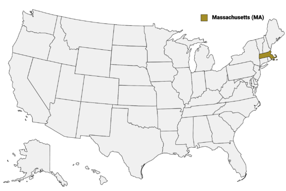
Massachusetts (MA) on the US Map
There are 14 counties in Massachusetts, although 8 of these are based on historical geographic regions and have a limited county-level government. The remaining six counties, located in the southeastern part of the state, have retained their local governments.
Each of the 14 counties in Massachusetts has its own history, landmarks, and events that make it unique. In this post, we’ll provide a detailed Massachusetts Counties Map as well as a closer look at each county.
Map of Massachusetts Counties
Below is a map of the 14 counties of Massachusetts (you can click on the map to enlarge it and to see the major city in each county).
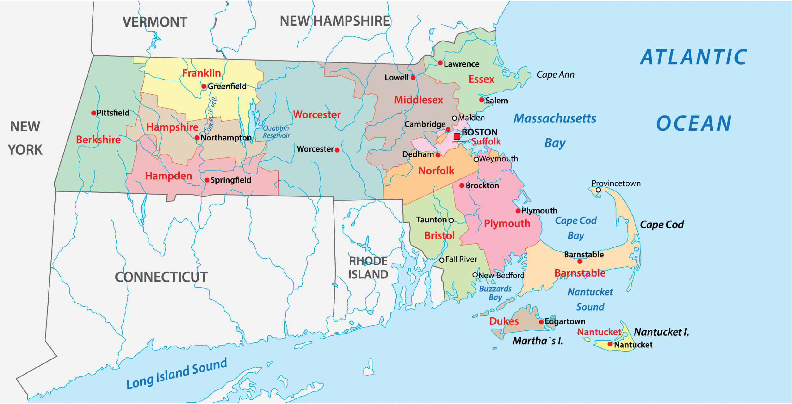
Interactive Map of Massachusetts Counties
Click on any of the counties on the map to see its population, economic data, time zone, and zip code (the data will appear below the map). Data is sourced from the US Census 2021.
List of the Counties of Massachusetts:
| County | Population | Per sq. km | Largest City |
|---|---|---|---|
| Barnstable County | 227,942 | 223.25 | Barnstable |
| Berkshire County | 129,089 | 53.77 | Pittsfield |
| Bristol County | 576,070 | 402.13 | New Bedford |
| Dukes County | 20,277 | 75.86 | Oak Bluffs |
| Essex County | 804,598 | 630.75 | Lynn |
| Franklin County | 71,085 | 39.25 | Montague |
| Hampden County | 466,265 | 291.77 | Springfield |
| Hampshire County | 161,810 | 118.5 | Northampton |
| Middlesex County | 1,623,411 | 766.39 | Cambridge |
| Nantucket County | 13,795 | 115.31 | Nantucket |
| Norfolk County | 720,403 | 702.21 | Quincy |
| Plymouth County | 527,602 | 309.35 | Brockton |
| Suffolk County | 792,647 | 5253.65 | Boston |
| Worcester County | 856,858 | 219 | Worcester |
Barnstable County

Barnstable County, situated on the scenic Cape Cod peninsula in Massachusetts, is a coastal gem known for its maritime character and historic charm. Established in 1685, the county is named after Barnstaple, England, and is distinguished by its iconic lighthouses, pristine beaches, and quaint villages.
The county seat, Barnstable Town, is known for its cobblestone streets and historic buildings. The region is celebrated for its vibrant arts scene, seafood cuisine, and outdoor activities, including whale watching and sailing. Its unique geography comprises both the sheltered Cape Cod Bay and the expansive Atlantic Ocean.
Barnstable County plays host to numerous cultural events, like the renowned Provincetown Carnival and Wellfleet OysterFest, drawing visitors from all over to experience its coastal allure and community spirit. Some of the county’s historic sites include the Pilgrim Monument and the natural beauty of the Cape Cod National Seashore.
Berkshire County

Berkshire County occupies the westernmost region of Massachusetts and is renowned for its picturesque landscapes and cultural richness. Established in 1761, the county is named after Berkshire in England and is based on a historical region. As such, it has a limited county government.
Pittsfield, the largest city and county seat, serves as the region’s economic and cultural hub. Berkshire County is a haven for arts and culture enthusiasts, home to renowned institutions like the Tanglewood Music Center and the Norman Rockwell Museum.
Berkshire County also hosts numerous cultural events and festivals, drawing visitors who appreciate its unique blend of natural beauty and cultural offerings. Its historical significance is highlighted by sites like the Hancock Shaker Village and the historic town of Stockbridge, offering glimpses into the region’s rich past.
Bristol County

Bristol County, located in southeastern Massachusetts, has a rich history and diverse cultural landscape. Established in 1685 from Plymouth Colony, it was named after its former county seat, which was subsequently annexed by Rhode Island in 1747.
Bristol County is distinguished by its blend of urban areas and picturesque rural landscapes. It is home to the cities of Fall River and New Bedford, each with its own unique historical and cultural identity. Fall River is known for its once-thriving textile industry, while New Bedford’s legacy as a historic whaling hub still echoes today.
The city of Taunton serves as the county seat and is known for its historical significance, particularly in colonial times. Bristol County is also recognized for its educational institutions and vibrant arts scene. The county features several higher education establishments, including the University of Massachusetts Dartmouth.
Dukes County

Dukes County, located off the southern coast of Massachusetts, is composed primarily of the islands of Martha’s Vineyard, Chappaquiddick Island, and the Elizabeth Islands. Incorporated in 1695, the county was named after the Duke of York, who later became King James II of England.
The county seat is Edgartown, a town known for its well-preserved whaling captain’s homes and the historic Edgartown Harbor Light. Dukes County is celebrated for its scenic beauty, characterized by sandy beaches, rolling hills, and picturesque farmlands.
The county’s cultural landscape is enriched by its artistic communities, local galleries, and the annual Martha’s Vineyard Film Festival and African-American Film Festival. The islands’ natural areas, including the Manuel F. Correllus State Forest and the Aquinnah Cliffs, offer opportunities for hiking, bird watching, and exploring diverse ecosystems.
Essex County

Essex County, located in northeastern Massachusetts, is steeped in colonial history and maritime heritage. Established in 1643, it is one of the oldest counties in the United States. The county seat is Salem, a city renowned for its 1692 witch trials and rich maritime history.
Essex County is known for its picturesque coastal towns like Marblehead and Newburyport, each with unique historic architecture and nautical charm. Salem, with landmarks such as the Salem Witch Museum and the Peabody Essex Museum, attracts visitors interested in early American history and art.
The county is also home to the Essex National Heritage Area, encompassing numerous sites that celebrate the region’s cultural and natural heritage. Annual events like the Salem Film Fest and the Topsfield Fair, one of the oldest agricultural fairs in the U.S., draw crowds for their unique cultural experiences.
Franklin County

Franklin County, situated in the northern part of Massachusetts, is known for its rural landscapes and rich agricultural heritage. Established in 1811, the city of Greenfield serves as the county seat and is a hub of activity amidst the county’s predominantly pastoral setting.
This county is characterized by its small towns and farmlands, contributing to Massachusetts’ agricultural output, especially in maple syrup production. It is also home to the Mohawk Trail, a historic and scenic route that runs through the county, offering stunning views of the fall foliage and the Connecticut River Valley.
Franklin County hosts various cultural and community events, including the Greenfield Farmers’ Market and the Franklin County Fair, showcasing local crafts, produce, and livestock. The region is also known for its outdoor recreational opportunities, with places like Mount Sugarloaf State Reservation providing settings for hiking, kayaking, and scenic drives.
Hampden County

Hampden County, located in the western part of Massachusetts, is known for its rich history and cultural diversity. Established in 1812, the county was named after John Hampden, a prominent English politician. The city of Springfield, the county seat, is recognized as the birthplace of basketball and is home to the Naismith Memorial Basketball Hall of Fame.
Springfield, the region’s economic and cultural hub, offers a mix of urban and historical attractions. The Springfield Armory National Historic Site, for example, reflects the city’s significant role in American history.
Hampden County is also noted for its higher education institutions, including Springfield College and Western New England University. The region’s cultural landscape is enriched by events like the annual Big E, the largest agricultural fair in the Northeast, held in West Springfield.
Hampshire County

Hampshire County, in the heart of western Massachusetts, is celebrated for its academic atmosphere and picturesque landscapes. Established in 1662, it’s among the earliest counties in the country. Northampton, the county seat, is known for its vibrant arts scene and historic architecture.
The county is home to the Five College Consortium, comprising Amherst College, Hampshire College, Mount Holyoke College, Smith College, and the University of Massachusetts Amherst. This academic presence enriches the region culturally and intellectually.
Hampshire County also boasts of the scenic Connecticut River and the Mount Holyoke Range State Park, offering ample outdoor activities like hiking and river sports. The area is known for events like the Amherst Farmers’ Market and the Northampton Arts Night Out, reflecting the county’s strong community spirit and appreciation for local arts and agriculture.
Middlesex County

Middlesex County, established in 1643, is one of the most populous counties in Massachusetts, named after a historic county in England. Its county seats, Cambridge and Lowell, each offer a unique blend of history and modernity.
Cambridge, renowned for its academic institutions like Harvard University and MIT, is a nexus of education and innovation. The city’s cultural vibrancy is evident in its diverse dining, museums, and theaters. Lowell’s history as a mill town is preserved in the Lowell National Historical Park, and its revitalized downtown reflects its industrial heritage.
The county also includes the Minute Man National Historical Park, marking the site of early Revolutionary War battles. The county is celebrated for hosting events like the Cambridge Science Festival and the Lowell Folk Festival, showcasing its cultural diversity and innovative spirit.
Nantucket County

Nantucket County, encompassing the isolated island of Nantucket and smaller surrounding islets, is the smallest county in Massachusetts by population and land area. It is unique as the entire county is coextensive with the Town of Nantucket. Named from a word in the language of the native Wampanoag tribe, the island is located about 30 miles south of Cape Cod.
Nantucket is renowned for its maritime history, once a major whaling hub in the 18th and 19th centuries. Today, it is known for its well-preserved historic architecture, with strict building codes maintaining its historic character.
Key landmarks include the Nantucket Whaling Museum and the Sankaty Head Lighthouse. The island’s natural beauty is preserved in areas like the Coskata-Coatue Wildlife Refuge, which offers opportunities for hiking and wildlife observation. Events like the Nantucket Film Festival and the Daffodil Festival celebrate the island’s unique charm and community spirit.
Norfolk County

Norfolk County, situated in eastern Massachusetts, was established in 1793. It was named after the English county of Norfolk. The county seat is Dedham, known for its historic character and as the site of the historic Sacco and Vanzetti trial.
Towns like Brookline and Quincy add to the county’s appeal with their own unique historical and cultural significance. Quincy, known as the “City of Presidents,” is the birthplace of U.S. Presidents John Adams and John Quincy Adams, and Brookline has notable sites like the John F. Kennedy National Historic Site.
Norfolk County also boasts a range of recreational areas, including the Blue Hills Reservation, which offers extensive trails for hiking and skiing, and the Neponset River Reservation, which provides scenic views and outdoor activities. The county’s proximity to Boston makes it a desirable location for those seeking a blend of suburban tranquility and urban accessibility.
Plymouth County

Plymouth County, located in southeastern Massachusetts, was established in 1685, deriving its name from the historic town of Plymouth, the site of one of the first successful English settlements in America. The county seat is Brockton, known for its industrial history and as the birthplace of boxing legends Rocky Marciano and Marvin Hagler.
Plymouth, the county’s namesake town, is a key historical site as the landing place of the Mayflower Pilgrims in 1620. The town is home to the Plimoth Patuxet Museums, a living history museum depicting the original settlement of the Plymouth Colony.
The county is also known for its picturesque coastal towns, such as Scituate and Marshfield, offering beautiful beaches and maritime activities. The natural beauty of the area is highlighted in places like Myles Standish State Forest, which provides ample opportunities for hiking, camping, and exploring the region’s diverse landscapes.
Suffolk County

Suffolk County, located in eastern Massachusetts, is one of the most populous counties in the state and was incorporated in 1643. It is named after Suffolk in England. The county comprises Boston, the state capital and largest city, along with Chelsea, Revere, and Winthrop
Boston, the county seat, is renowned for its historical significance in the American Revolution, evident in landmarks like the Freedom Trail, a 2.5-mile route connecting sites such as the Old North Church and the Bunker Hill Monument. The city is also a major center for education and culture, hosting world-class institutions like Harvard University and the Museum of Fine Arts.
Chelsea, Revere, and Winthrop each contribute to the county’s diverse urban landscape. Chelsea is known for its industrial history and vibrant arts scene, Revere for its beachfront and annual Sand Sculpting Festival, and Winthrop for its quaint small-town feel within the metropolitan area.
Worcester County

Worcester County, the largest county in Massachusetts by area, was established in 1731. It is named after Worcester, England. The city of Worcester, the county seat, is known as the “Heart of the Commonwealth” due to its central location in the state.
The city of Worcester is a cultural and educational hub, home to numerous colleges and universities, including the prestigious College of the Holy Cross and Worcester Polytechnic Institute.
The county’s landscape is diverse, featuring urban areas, quaint towns, and rural countryside. It offers a range of recreational opportunities, from the ski slopes of Wachusett Mountain to the hiking trails of the Quabbin Reservoir.
Worcester County hosts a variety of cultural events and festivals, like the Worcester Music Festival and the Sturbridge Harvest Festival, showcasing the region’s rich artistic and agricultural heritage.
More about Massachusetts Counties: FAQs
Which Massachusetts county has the largest population?
Middlesex County is the most populous county in Massachusetts.
What is the smallest county in Massachusetts by area?
Nantucket County is the smallest by land area, covering 47.8 sq mi (123.8 km2).
Which county in Massachusetts is known for its connection to the American Revolution?
Suffolk County, particularly Boston, is well-known for its pivotal role in the American Revolution.
Which Massachusetts counties consist of islands?
Dukes County and Nantucket County are primarily composed of islands.

- Serene Coastal View of Provincetown with Boats and Beachfront Buildings in Cape Cod, Massachusetts — © lunamarina/Shutterstock
- Aerial View of Downtown Pittsfield, Massachusetts with Cloudy Skies — © Jacob Boomsma/Shutterstock
- Bristol County Superior Court Building in Taunton, Massachusetts on a Clear Day — © quiggyt4/Shutterstock
- Scenic View of Gay Head Lighthouse Overlooking Colorful Cliffs and Ocean — © Rolf_52/Shutterstock
- Aerial View of a Brick Church with a Steeple in a Coastal Town — © Wangkun Jia/Shutterstocke
- Autumnal View of the Connecticut River Winding Through a Lush Landscape at Sunset — © Romiana Lee/Shutterstock
- Dusk Skyline Reflections of Springfield, Massachusetts Over the River — © Sean Pavone/Shutterstock
- Aerial View of Northampton, Massachusetts, Showcasing the Town Center and Surrounding Community — © Harold Stiver/Shutterstock
- Aerial View of Historic Brick Buildings Along a Street — © Roman Babakin/Shutterstock
- Aerial View of Nantucket Harbor Entrance, Massachusetts — © TeBe Inspires/Shutterstock
- Classical Architecture of a Public Building on a Quiet Street in Dedham, Massachusetts — © quiggyt4/Shutterstock
- Aerial View of a 17th-Century Ship Reproduction Docked at Plymouth Harbor — © Wangkun Jia/Shutterstock
- Dusk Over Suffolk County Skyline in Boston, Massachusetts — © GagliardiPhotography/Shutterstock
- Aerial View of a Picturesque College Campus with Historic Buildings and Lush Greenery — © Wangkun Jia/Shutterstock