Located in the far northeastern corner of the United States, Maine is a state unlike any other. Some of its claims to fame are its maritime heritage, beautiful coastlines, and lobster. The indigenous inhabitants of what is now Maine were the Algonquin-speaking Wabanaki peoples.
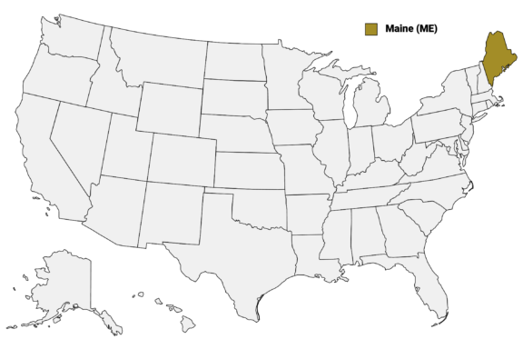
Maine (ME) on the US Map
There are 16 counties in Maine, each with its own unique history and culture. In this post, we’ll take a look at each of these counties, starting with a Maine Counties Map that highlights the major city in each.
Map of Maine Counties
Below is a map of the 16 counties of Maine (you can click on the map to enlarge it and see the major city in each county).
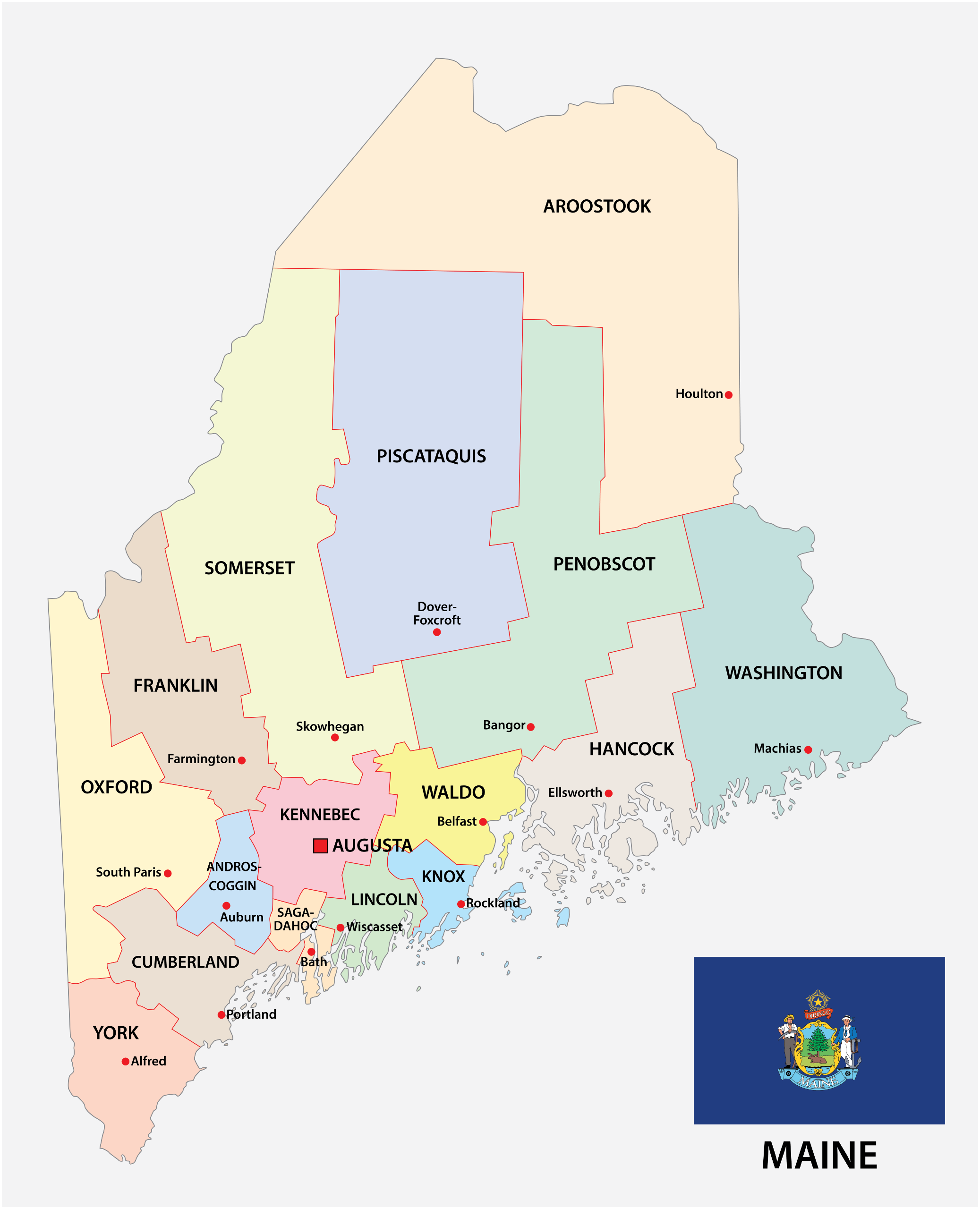
Interactive Map of Maine Counties
Click on any of the counties on the map to see its population, economic data, time zone, and zip code (the data will appear below the map). Data is sourced from the US Census 2021.
List of the Counties of Maine:
| County | Population | Per sq. km | Largest City |
|---|---|---|---|
| Androscoggin County | 110,378 | 91.07 | Lewiston |
| Aroostook County | 67,272 | 3.89 | Presque Isle |
| Cumberland County | 300,776 | 138.87 | Portland |
| Franklin County | 29,487 | 6.71 | Farmington |
| Hancock County | 55,417 | 13.48 | Ellsworth |
| Kennebec County | 123,293 | 54.88 | Augusta |
| Knox County | 40,519 | 42.84 | Rockland |
| Lincoln County | 35,065 | 29.7 | Waldoboro |
| Oxford County | 57,807 | 10.75 | Rumford |
| Penobscot County | 152,211 | 17.3 | Bangor |
| Piscataquis County | 16,760 | 1.63 | Dover-Foxcroft |
| Sagadahoc County | 36,530 | 55.53 | Topsham |
| Somerset County | 50,424 | 4.96 | Skowhegan |
| Waldo County | 39,618 | 20.96 | Belfast |
| Washington County | 31,003 | 4.67 | Calais |
| York County | 210,486 | 81.99 | Biddeford |
Androscoggin County

Androscoggin County, located in southern Maine, boasts a rich blend of history and modernity. Its name comes from the Androscoggin River, and it was formed in 1854 by the combination of several towns in other counties.
Its past is deeply intertwined with the textile industry, evident in the historic mills that dot its landscape, especially around the city of Lewiston, its largest city. The county has transitioned to a more diverse economic base, including healthcare and education, with Bates College as a notable landmark.
Cultural diversity is a key feature here, with a significant influx of Somali and other immigrants enriching the community with new cultures and traditions. Events in Lewiston include the monthly Art Walk and the Bates Dance Festival.
Aroostook County

Aroostook County, known as “The Crown of Maine,” stands as the state’s largest by land area, with vast stretches of wilderness and agricultural lands. Formed in 1839, it’s renowned for its potato farming, something that contributes significantly to Maine’s agricultural output.
Its rural character gives Aroostook County a tranquil, pastoral atmosphere, punctuated by small towns and close-knit communities. The county’s history is vividly captured in the Presque Isle Air Museum, commemorating its strategic role during World War II.
Aroostook is also a paradise for outdoor enthusiasts, offering a plethora of activities from snowmobiling on its well-groomed trails to bird watching and hiking in the North Maine Woods. The annual Potato Blossom Festival is a highlight, celebrating the county’s agricultural heritage with parades, fireworks, and community gatherings.
Cumberland County

The most populous county in Maine is Cumberland County, a vibrant blend of urban development and natural beauty. Established in 1760, it is home to Portland, the state’s largest city, known for its historic Old Port district and thriving arts scene. The county’s economy is diverse, with a strong presence in healthcare, education, and technology.
Culturally, Cumberland is a hub of activity. It hosts the renowned Portland Museum of Art and the annual Maine Jewish Film Festival, showcasing its commitment to arts and multiculturalism. The county’s scenic coastline, including the iconic Portland Head Light in Cape Elizabeth, attracts visitors year-round, offering breathtaking views and outdoor activities.
Another noteworthy aspect of the county is Cumberland’s culinary scene, with Portland often hailed as a foodie destination for its innovative and locally sourced cuisine.
Franklin County

Franklin County, established in 1838, is a picturesque region known for its mountainous terrain and lively outdoor activities. Situated in the western part of Maine, it’s home to Sugarloaf Mountain, a premier destination for skiing enthusiasts. The county’s natural beauty is a major draw, with the Appalachian Trail and Rangeley Lake offering abundant opportunities for hiking, fishing, and boating.
The county’s economy is rooted in forestry and agriculture, but it has also seen growth in tourism and renewable energy, particularly wind power. Franklin’s cultural landscape is enriched by its history, with the Farmington Historical Society Museum showcasing local heritage.
Each year, the county celebrates the Wilton Blueberry Festival, an event that highlights the local agricultural produce and community spirit. The Maine Fiddlehead Festival is another popular food festival in the country.
Hancock County

Hancock County, formed in 1789, is famed for its stunning coastline and the world-renowned Acadia National Park. This county offers a breathtaking mix of ocean, mountains, and forests, making it a magnet for nature lovers and outdoor enthusiasts.
Bar Harbor, one of its most famous towns, serves as a gateway to Acadia and is a bustling hub of tourism, with a variety of shops, restaurants, and galleries. The largest city and county seat is Ellsworth, located in the middle of the county.
The maritime heritage of Hancock County is profound, with a long history of shipbuilding and fishing. This legacy is celebrated in the annual Winter Harbor Lobster Festival, a testament to the county’s strong connection to the sea. Additionally, the area’s rich artistic tradition is showcased in the numerous art galleries and studios of Ellsworth and Southwest Harbor.
Kennebec County

Kennebec County, established in 1799, is anchored by Augusta, Maine’s capital city. The county is steeped in political and historical significance, with the Maine State House and the Maine State Museum providing insights into the state’s rich history.
Augusta’s historic downtown, with its charming architecture and vibrant arts scene, adds to the county’s appeal. The Kennebec River Rail Trail offers a picturesque route for walkers and cyclists, showcasing the area’s natural beauty.
The county also hosts various cultural events, such as the Old Hallowell Day and the Augusta Civic Center’s concerts and exhibitions, which draw visitors from across the state.
Knox County

Knox County was created in 1860 from parts of Lincoln and Waldo counties and is a maritime jewel along Maine’s coast. Known for its iconic lighthouses, including the famous Rockland Breakwater Lighthouse, the county is deeply connected to the sea. Rockland, the county seat, hosts the annual Maine Lobster Festival, which draws seafood enthusiasts from far and wide.
The county’s maritime history is also celebrated at the Maine Lighthouse Museum and the Maine Maritime Museum. Rockport and Camden, two picturesque towns in Knox County, offer stunning views of Penobscot Bay and are popular for sailing and other water activities.
Knox County’s artistic side is evident in its thriving arts scene, with the Farnsworth Art Museum in Rockland featuring a collection of Maine-inspired art. The Camden International Film Festival is another cultural highlight, bringing innovative documentaries to a local and international audience.
Lincoln County

Lincoln County, formed in 1760, is one of Maine’s earliest counties, offering a rich historical tapestry and serene coastal beauty. Damariscotta, the county seat, is known for its charming downtown and the Pemaquid Point Lighthouse, a symbol of Maine’s maritime heritage.
The county’s connection to the sea is also evident in its thriving oyster farming industry, with the Damariscotta River Oyster Festival celebrating this vital part of the local economy.
The region’s history is further explored at the Colonial Pemaquid State Historic Site, showcasing Maine’s colonial past. Lincoln County’s natural landscapes, including the tranquil Boothbay Harbor, provide a haven for boating, fishing, and coastal exploration.
Oxford County

Oxford County, established in 1805 and previously inhabited by members of the indigenous Abenaki Nation is known for its picturesque landscapes and outdoor recreational opportunities. The county is home to the Sunday River and Mt. Abram ski resorts, making it a popular destination for winter sports enthusiasts.
During the warmer months, the area’s lakes and mountains, including the scenic Grafton Notch State Park, attract hikers, campers, and nature lovers.
Bethel, a charming town in Oxford County, serves as a gateway to the region’s outdoor activities and hosts numerous events throughout the year, such as Summerfest, celebrating local history and culture. Oxford County is also noted for its mineralogy, with the Maine Mineral and Gem Museum in Bethel showcasing a remarkable collection of geological specimens.
Penobscot County

Penobscot County, formed in 1816, is a dynamic blend of history, culture, and natural beauty. Bangor, the county seat, is known for its rich lumber history and as the former “Lumber Capital of the World.” The city’s 19th-century architecture and the historic Bangor Waterfront reflect this legacy.
The University of Maine in Orono is a significant presence in the county, contributing to its vibrant cultural and educational scene. The Collins Center for the Arts on the university campus offers a variety of performances and events. In Bangor, the American Folk Festival is a significant event celebrating the region’s diverse cultural heritage through music, dance, and food.
Penobscot County is also a gateway to the Maine Highlands, with its vast forests and waterways providing ample opportunities for outdoor activities like hiking, fishing, and canoeing.
Piscataquis County

Piscataquis County, Maine’s least populous, was established in 1838 and is known for its vast wilderness areas. The county encompasses a large portion of the Maine Highlands, including the northern section of the Appalachian Trail and the majestic Mount Katahdin, Maine’s highest peak and the northern terminus of the Appalachian Trail.
Dover-Foxcroft, the county seat, embodies the quiet, rural charm of the area with its historic buildings and small-town atmosphere. Piscataquis is a haven for outdoor enthusiasts, offering unparalleled opportunities for hiking, camping, and wildlife observation in areas like Baxter State Park and Moosehead Lake, the largest mountain lake in the eastern United States.
The county’s economy historically revolved around logging and paper mills, and this heritage is still evident in the landscape and culture. Piscataquis County’s remote beauty and unspoiled natural environments offer a tranquil and authentic Maine wilderness experience.
Sagadahoc County

Sagadahoc County, established in 1854, is known for its rich maritime history and picturesque coastal landscapes. Located at the mouth of the Kennebec River, it includes the historic city of Bath, often referred to as the “City of Ships” due to its long-standing shipbuilding heritage.
The Maine Maritime Museum in Bath celebrates this legacy, showcasing the county’s connection to Maine’s naval history.
Bath’s charming downtown area, with its well-preserved 19th-century architecture, offers a glimpse into the county’s past. Popham Beach State Park and Reid State Park in Sagadahoc County are popular destinations, known for their beautiful sandy beaches and scenic views of the Atlantic Ocean.
The county also hosts the annual Bath Heritage Days, a celebration featuring parades, fireworks, and music, highlighting the community’s spirit and traditions.
Somerset County

Somerset County was established in 1809, 11 years before Maine became a state. The county is steeped in history and natural beauty, with its vast forests and rolling hills. Skowhegan, the county seat, is known for its rich agricultural heritage, exemplified by the annual Skowhegan State Fair, one of the oldest fairs in the United States.
The Kennebec River flows through Somerset County, providing excellent opportunities for fishing and kayaking. The county is also home to portions of the scenic Appalachian Trail, attracting hikers from around the world.
Somerset’s history is deeply connected to the lumber industry, and this legacy is still visible in its towns and landscapes. The county has been adapting to a more diverse economy, with a growing emphasis on tourism and renewable energy.
The Lakewood Theater in Madison, the oldest continuously running summer theater in America, adds a unique cultural dimension to the county.
Waldo County

Waldo County, formed in 1827, is a blend of picturesque rural landscapes and coastal charm. Located in central Maine, it is home to Belfast, the county seat, known for its historic downtown with beautifully restored architecture and vibrant arts scene. Belfast’s waterfront, once a shipbuilding hub, now serves as a scenic spot for community events and local gatherings.
The county is also celebrated for its agricultural heritage, seen in its numerous farms and the annual Common Ground Country Fair in Unity, a showcase of organic farming, sustainability, and rural living.
Outdoor recreation is abundant in Waldo County, with opportunities for hiking, boating, and fishing in its lakes and along the coastline. The region’s natural beauty is exemplified by Lake St. George State Park, offering serene landscapes for relaxation and exploration.
Washington County

Washington County, established in 1790, is Maine’s easternmost county, known for its rugged coastline and rich maritime history. The city of Eastport, part of Washington County, holds the distinction of being the easternmost city in the United States. The county’s economy has long been tied to the sea, with fishing and aquaculture playing significant roles.
The region is renowned for its wild blueberries, with vast fields covering much of the county’s landscape. The annual Machias Wild Blueberry Festival celebrates this important crop, drawing visitors and locals alike.
Washington County is also home to the Passamaquoddy Tribe, with the Sipayik and Indian Township reservations located within the county.
York County

York County, established in 1636, is Maine’s southernmost county and the oldest in the state. It’s known for its picturesque beaches, historic sites, and vibrant tourist industry. The county seat, Alfred, is home to notable historic buildings, while the coastal town of Kennebunkport attracts visitors with its charming streets and seafood restaurants.
The county’s rich history is evident in the Old York Historical Society, which preserves and presents the region’s heritage through its museums and historic buildings. York’s beaches, such as Ogunquit Beach and Wells Beach, are popular summer destinations.
York County is also home to the Rachel Carson National Wildlife Refuge, a testament to its commitment to preserving natural habitats and wildlife. The refuge provides a serene environment for birdwatching and exploring Maine’s diverse ecosystems.
More about Maine Counties: FAQs
Which is the newest county in Maine?
Knox County, established in 1860 from parts of Lincoln and Waldo Counties, is the newest in the state.
Are there any counties in Maine without a coastline?
Yes, there are eight counties without a coastline in Maine. Some of these are Piscataquis, Somerset, and Oxford.
Which county in Maine has the highest population?
With just over 300,000 residents, Cumberland County has the highest population. This is partly due to the presence of Portland, Maine’s largest city.
Which of Maine’s counties is the wealthiest?
Cumberland County is generally considered the wealthiest county in Maine because of its diverse economy, high property values, and the presence of Portland, Maine’s largest city.
Which county in Maine has the lowest cost of living?
Piscataquis County is often cited as having the lowest cost of living in Maine due to lower housing costs, lower property values, and overall lower expenses compared to more urbanized or coastal counties in the state.
Image Sources and Copyright Information
- Aerial View of Lewiston, Maine with Prominent City Signage on Waterfront: © James Aloysius Mahan V/Shutterstock
- Wind Turbines Overlooking a Lush Landscape at Mars Hill in Aroostook County: © Danita Delimont/Shutterstock
- Aerial View of the Cathedral of the Immaculate Conception in Portland, Cumberland County, with Cityscape and Waterfront: © Wangkun Jia/Shutterstock
- Aerial View of a Snow-Capped Mountain with Ski Slopes and Surrounding Forest: © IronLifeMoney/Shutterstock
- Autumn Foliage Surrounding a Serene Lake in Acadia National Park: © Lukas Proszowski/Shutterstock
- Scenic View of Augusta, Maine Skyline Along the Kennebec River: © Sean Pavone/Shutterstock
- Summer Festival at a Bustling Seaside Marina with Tents and Boats: © Wangkun Jia/Shutterstock
- Sunset Glow at Pemaquid Point Lighthouse Overlooking the Atlantic Ocean: © Doug Lemke/Shutterstock
- Vintage Americana: An Eclectic Collection of Old Signs on a Rustic Country Store: © jenlo8/Shutterstock
- Statue of Paul Bunyan in front of a Modern Building under a Blue Sky with Clouds: © EWY Media/Shutterstock
- Hiker Standing on the Knife Edge Trail with Panoramic Mountain Views: © Kazela/Shutterstock
- Sagadahoc County Courthouse and Monument Adorned with American Flags: © Burcu Ergin/Shutterstock
- Autumn Splendor Along the Kennebec River in Somerset County, Maine: © L Paul Mann/Shutterstock
- Downtown Street View with Historic Architecture on a Sunny Day: © Enrico Della Pietra/Shutterstock
- Aerial View of a Coastal Town with Historic Buildings and Boats Docked at the Harbor: © leo w kowal/Shutterstock
- Colorful Boats and Quaint Buildings Along the Waterfront in Kennebunkport, Maine: © Pernelle Voyage/Shutterstock