A world map poster can transform a blank wall into a window on the planet. Whether you want a reference tool for your home office, a teaching aid for a classroom, or a striking piece of decor, the right poster delivers geographic detail and visual appeal in equal measure.
We researched and compared dozens of world map posters available in 2026, evaluating them on cartographic accuracy, print quality, size options, durability, and value. Our 9 picks cover everything from massive laminated wall maps and premium National Geographic prints to vintage-style art posters and kid-friendly educational sets. Prices range from under $10 to around $40.
Below are the best world map posters, ranked by overall quality and value.
When you buy through links on this page, we may earn an affiliate commission. Commission payments do not affect the evaluations of the products.
Best World Map Posters
1. Maps International Giant World Map
- Best for: Large-format wall display with maximum detail
- Size: 46 x 80 inches
- Style: Colorful political map, fully laminated
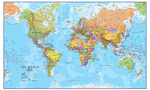
The Maps International Giant World Map is the largest single-sheet world map poster available on Amazon, and that sheer scale is its defining feature. At 46 by 80 inches, it dominates any wall it occupies, making country borders, cities, and geographic details visible from across a room.
The map uses a bold, colorful palette where each country is assigned a distinct shade, making borders easy to identify at a glance. Cartographic data was updated in 2025, so recent geopolitical changes are reflected. The fully laminated surface is a practical bonus — it is write-on and wipe-off, which makes it useful for travel planning, classroom activities, or tracking visited destinations with dry-erase markers.
One caveat: a poster this large requires serious wall space and careful mounting. It ships rolled in a tube to avoid creases, but hanging an 80-inch-wide map takes some planning. For anyone with the room for it, though, this is the definitive statement piece.
Pros
- Largest single-sheet world map available (46 x 80 inches)
- Fully laminated with write-on/wipe-off surface
- Updated 2025 cartography
- Ships rolled to prevent creases
Cons
- Requires very large wall space
- Mounting an 80-inch poster can be challenging
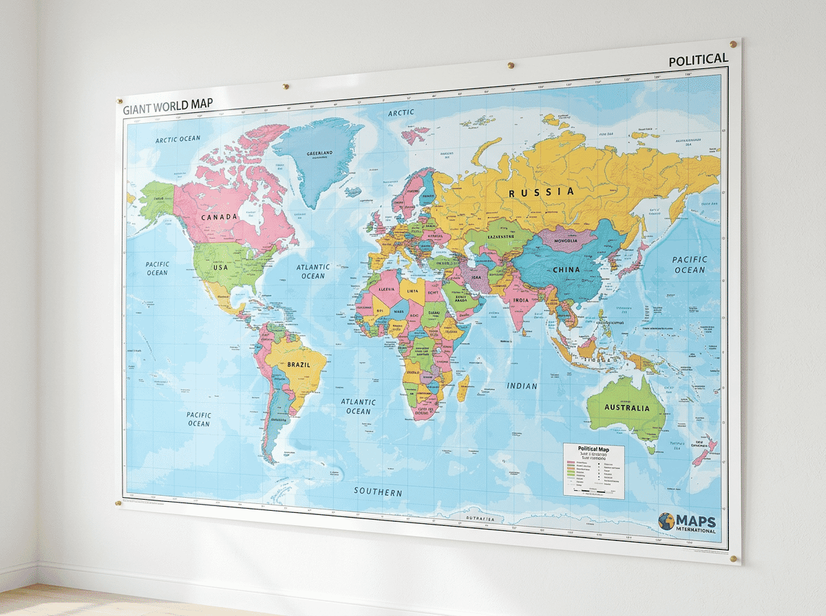
2. National Geographic Decorator World Wall Map
- Best for: Premium cartographic quality and refined aesthetics
- Size: 46 x 30.5 inches
- Style: Earth-tone decorator palette, laminated

The National Geographic Decorator World Wall Map carries the weight of the most trusted name in cartography. This is a map designed to look as good on a living room wall as it does in a study — the decorator palette uses warm earth tones instead of the bold primary colors typical of political maps, giving it a sophisticated appearance that complements most interior styles.
Beyond aesthetics, the cartographic detail is outstanding. Terrain shading reveals mountain ranges, deserts, and ocean depths with subtle accuracy. Country borders, capital cities, and major geographic features are all clearly marked. At 46 by 30.5 inches and laminated, it is durable enough for daily reference without being so large that it overwhelms a room.
The only real downside is that the muted color palette, while elegant, can make it harder to distinguish neighboring countries compared to brighter political maps. If quick country identification is your priority, a bolder-colored option may serve better. But for sheer quality of print and design, National Geographic sets the standard.
Pros
- National Geographic cartographic accuracy
- Warm earth-tone palette suits home and office decor
- Detailed terrain and ocean floor shading
- Laminated for durability
Cons
- Muted colors make neighboring countries harder to distinguish
- Higher price point than basic posters
3. PalaceLearning Laminated World & US Map Set
- Best for: Budget-friendly two-map bundle for classrooms and kids’ rooms
- Size: 18 x 29 inches (each)
- Style: Bright political map with bonus US map, laminated

The PalaceLearning Laminated World and US Map Set is one of the best-selling map poster products on Amazon, and the reason is straightforward: you get two laminated posters for around $13. The world map and accompanying US map both measure 18 by 29 inches — compact enough for a dorm room or classroom wall, but large enough that text and borders remain legible.
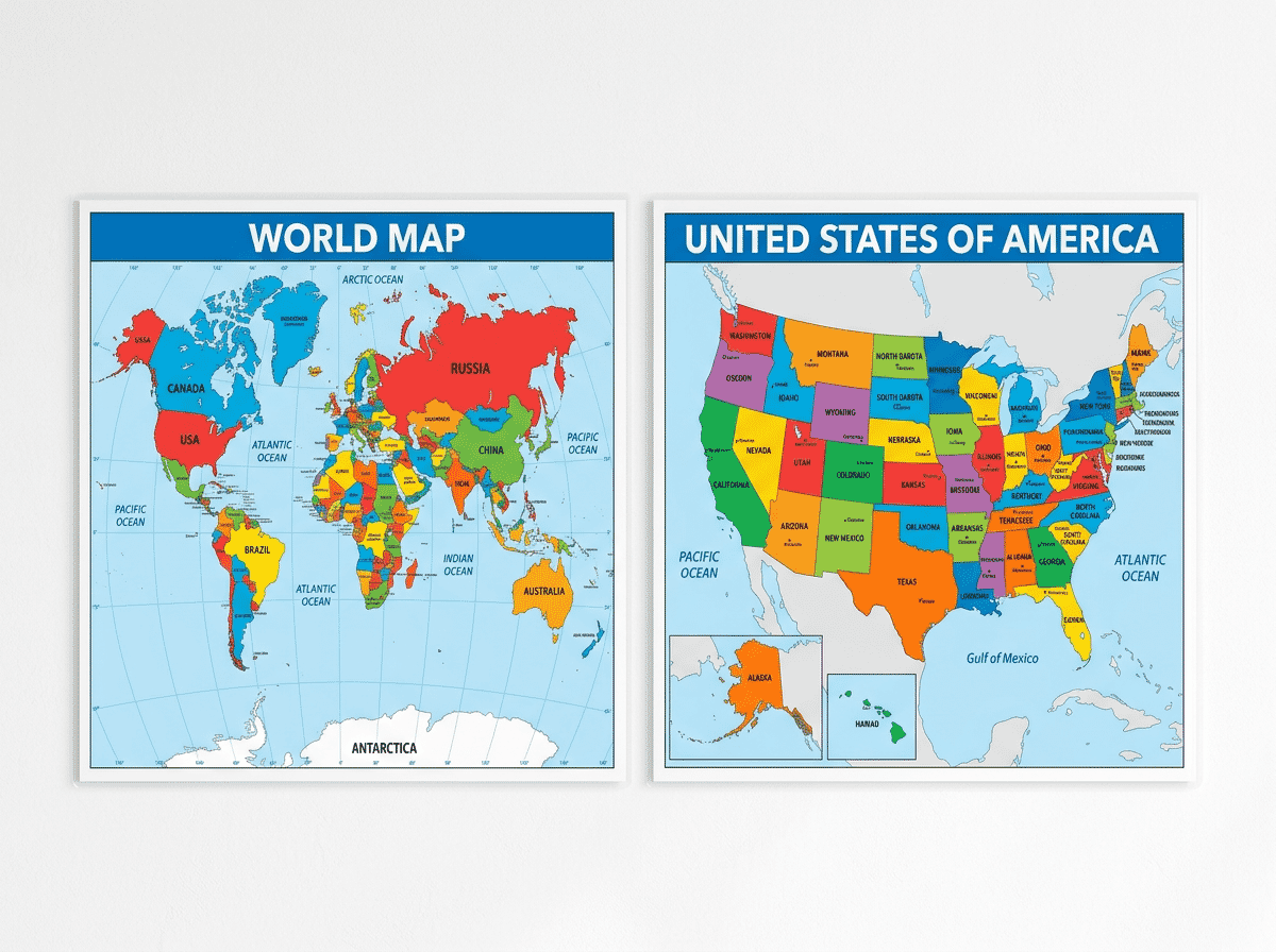
Colors are bright and cheerful, with each country and US state assigned its own hue for easy identification. Lamination makes both maps durable and resistant to tearing, which is a real advantage in classrooms or children’s rooms where posters take more abuse. Longitude and latitude lines, major cities, capitals, and geographic features are all included.
The trade-off is size and detail. At 18 by 29 inches, smaller countries and island nations can be difficult to read, and the level of detail does not match larger or premium maps. But for the price, this set is hard to beat as a practical everyday reference.
Pros
- Exceptional value — two maps for the price of one
- Laminated for long-term durability
- Nearly 10,000 reviews with a 4.8-star average
- Bright, easy-to-read color coding
Cons
- Smaller 18 x 29 inch size limits fine detail
- Less cartographic detail than premium maps
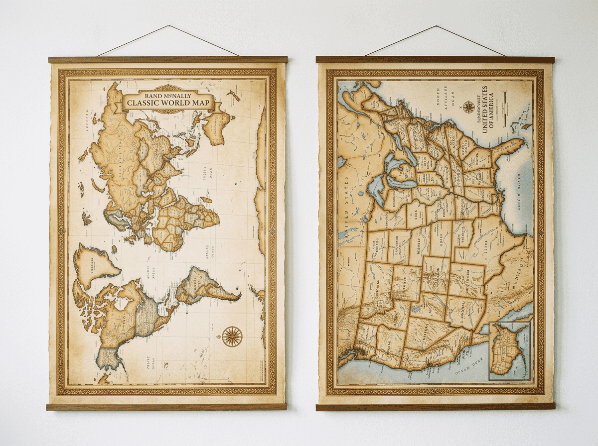
4. Rand McNally Classic Edition World Wall Map
- Best for: Traditional cartographic style from a trusted brand
- Size: 50 x 32 inches
- Style: Classic warm-toned design, laminated and rolled
Rand McNally has been producing maps since 1856, and the Classic Edition World Wall Map reflects that heritage. The design uses warm, understated tones — think creams, soft greens, and muted blues — that give it a timeless, almost antique quality without sacrificing modern accuracy. The 2025 edition includes the latest geopolitical updates.
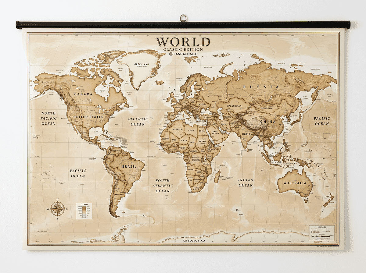
At 50 by 32 inches, this is a substantial map that fills a wall nicely without being overwhelming. The laminated surface protects against everyday wear, and rolled shipping ensures it arrives crease-free. Terrain relief is shown through subtle shading, and major cities, rivers, and physical features are all labeled clearly.
With a 4.8-star average across 2,000 reviews, this is one of the most consistently well-reviewed world map posters available. The only limitation is that the warm color scheme, while attractive, can make it slightly harder to differentiate some countries compared to brighter political maps.
Pros
- Trusted Rand McNally cartography (updated 2025)
- Elegant warm-toned design works as decor
- Generous 50 x 32 inch size
- Laminated and shipped rolled
Cons
- Muted palette may not suit users who prefer bold country colors
- Mid-range price
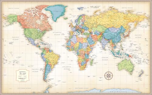
5. Swiftmaps World Premier Wall Map Poster
- Best for: Budget shoppers who want detail and ocean topography
- Size: 24 x 36 inches
- Style: Bright political map with 3D ocean floor shading
At under $10 for the paper version, the Swiftmaps World Premier is the most affordable detailed world map poster on this list. But the low price does not mean low quality — over 8,000 reviewers have given it a 4.6-star average, which speaks to consistent satisfaction.
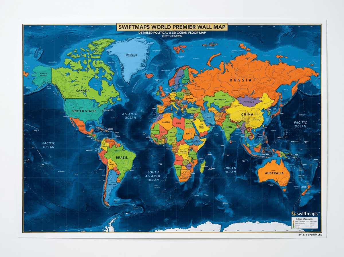
Each country is drawn to scale and assigned a distinct color, making borders easy to identify. The standout visual feature is the 3D topographic shading of the ocean floor, which adds depth and visual interest that most budget maps skip entirely. All countries and landmasses are correctly scaled, and major cities, waterways, and geographic features are labeled.
Swiftmaps offers both paper and laminated versions, as well as folded and rolled shipping options. The paper version is ideal if you plan to frame it; the laminated version adds durability for direct wall mounting. For the price, this poster delivers a remarkable amount of detail and visual quality.
Pros
- Best value on the list — under $10 for paper version
- Detailed 3D ocean floor topography
- Available in paper, laminated, folded, or rolled
- Over 8,000 reviews with strong ratings
Cons
- Paper version is not durable for direct wall mounting
- 24 x 36 inch size limits readability of small text
6. The World Game Large Educational World Map
- Best for: Classrooms and homeschool — countries with flags and capitals
- Size: 38 x 26 inches
- Style: Colorful political map with national flags border

The World Game Large Educational World Map packs more learning content per square inch than any other poster here. Every country is shown with its flag and capital city, making it a practical reference tool for geography studies. The flags are arranged along the border, creating a colorful frame that doubles as a quick visual index.
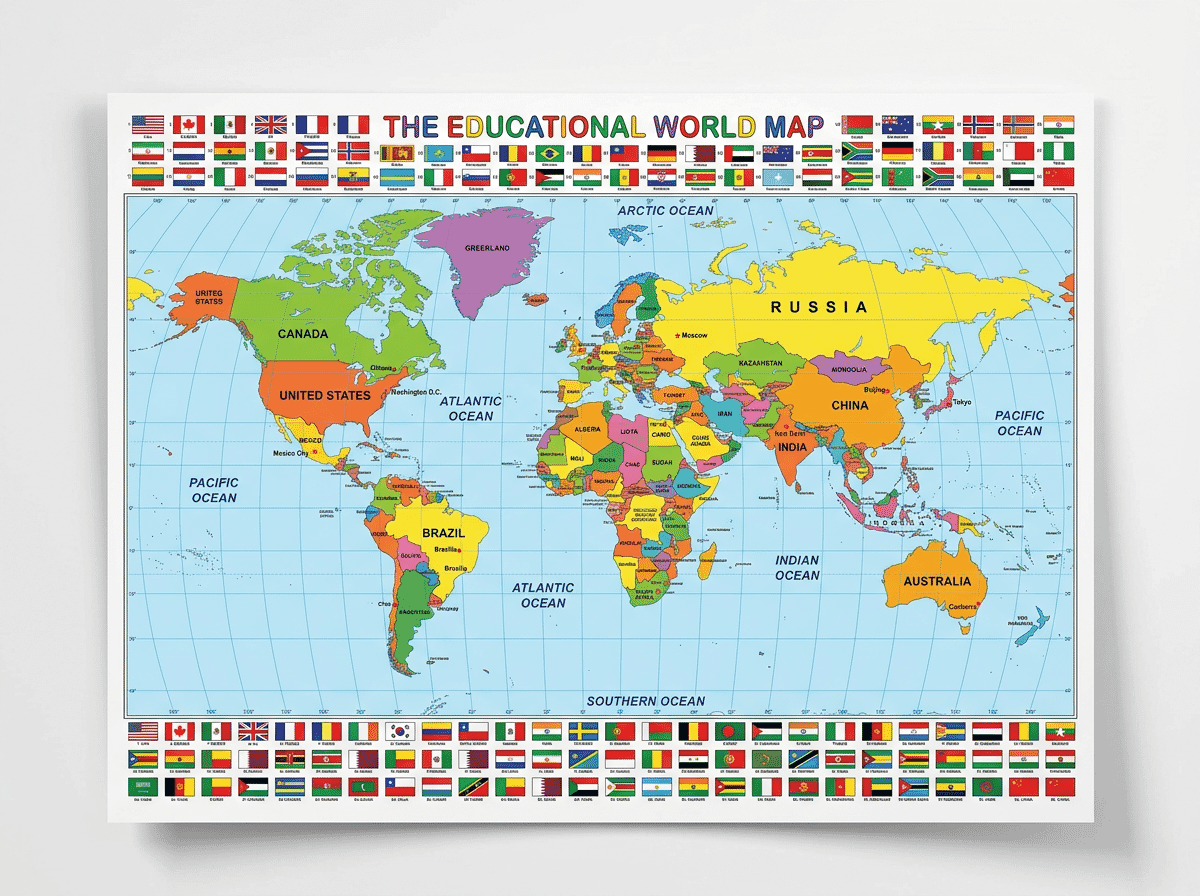
At 38 by 26 inches, it offers a solid size for classroom walls or home offices. The matte finish reduces glare, making it easier to read under fluorescent or bright lighting — a practical consideration for school environments. Colors are vibrant and distinct enough to differentiate neighboring countries easily.
The map is designed by The World Game, a company that makes geography-focused board games and learning tools, so the educational layout reflects genuine pedagogical thinking. The one trade-off is that including flags and capitals takes up space, so the map itself carries less topographic and physical geography detail than a dedicated reference map.
Pros
- Includes all country flags and capital cities
- Matte finish reduces glare in bright rooms
- Designed by a geography education company
- Good mid-range size (38 x 26 inches)
Cons
- Less topographic detail than reference maps
- Not laminated
7. GB Eye Antique World Map Art Poster
- Best for: Vintage decor and art-style wall display
- Size: 24 x 36 inches
- Style: Antique/vintage parchment aesthetic

The GB Eye Antique World Map Poster is designed for people who want a map that functions primarily as wall art. The vintage parchment coloring and old-world cartographic styling make it a striking decorative piece, and at 24 by 36 inches, it fits standard poster frames easily — no special mounting required.
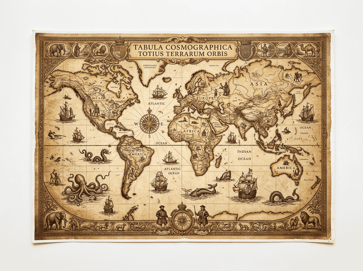
The sepia and cream tones evoke classic exploration-era maps, complete with decorative elements that give it genuine character. It ships in a cardboard mailing tube to arrive crease-free. With over 1,700 reviews and a 4.5-star rating, buyers consistently praise its visual impact and print quality.
This is not a map for looking up precise borders or identifying capital cities — the antique styling prioritizes atmosphere over geographic precision. If you want a beautiful vintage map to frame and display, this delivers. For reference accuracy, look elsewhere on this list.
Pros
- Beautiful vintage aesthetic works as wall art
- Standard 24 x 36 size fits common frames
- Ships in protective tube
- Affordable price point
Cons
- Not suitable as a geographic reference map
- Not laminated — needs framing for protection
8. RMC Classic US and World Wall Map Set
- Best for: Premium two-map set with classic antique styling
- Size: 32 x 50 inches (each)
- Style: Tea-stained classic look with elegant borders
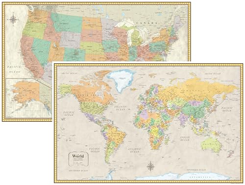
The RMC Classic United States and World Wall Map Set pairs two large-format maps from Rand McNally in a classic antique-inspired style. Each map measures a generous 32 by 50 inches and is printed on heavy-duty 80-pound paper stock, giving them a substantial feel that sets them apart from thinner posters.
The tea-stained color scheme gives both maps an elegant, antique appearance with warm earth tones and decorative border patterns. Despite the vintage look, the cartographic data is accurate and current. Cities, rivers, mountain ranges, and political boundaries are all clearly marked with readable typography.
Both maps ship rolled to prevent creases and come laminated for durability. The combination of large size, premium paper, Rand McNally accuracy, and the classic aesthetic makes this set a strong choice for offices, libraries, or living rooms where you want maps that function as both reference tools and decor.
Pros
- Two large 32 x 50 inch maps in one set
- Heavy-duty 80lb paper stock
- Elegant antique styling with modern accuracy
- Laminated and shipped rolled
Cons
- Higher price than single-map options
- Requires wall space for two large posters
9. Momo & Nashi World Maps for Kids
- Best for: Young children and toddlers
- Size: 24 x 16 inches (each)
- Style: Bright, illustrated, waterproof educational posters

The Momo & Nashi World Maps for Kids set is specifically designed for younger learners. The two-poster bundle includes a world map and a United States map, both featuring artist-commissioned illustrations with bright colors, playful fonts, and engaging visual design that makes geography feel fun rather than academic.
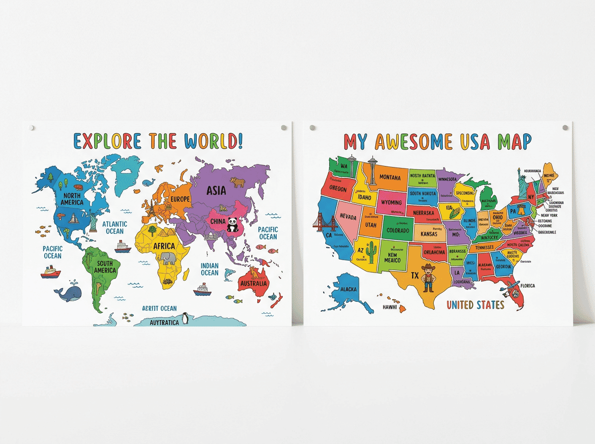
Each poster measures 24 by 16 inches — a compact size that fits well in children’s bedrooms, playrooms, or classroom walls. The waterproof coating is a genuinely useful feature for environments where little hands are involved, as it resists spills and can be wiped clean. Facts and figures are updated with current data, presented in age-appropriate language.
With a 4.8-star average across over 4,300 reviews, this is one of the highest-rated kids’ map products on Amazon. The only limitation is the compact size — fine for a bedroom wall, but too small for a full classroom geography display.
Pros
- Designed specifically for children with engaging illustrations
- Waterproof and durable for kids’ environments
- Two-poster set (world + US)
- 4.8 stars across 4,300+ reviews
Cons
- Small 24 x 16 inch size
- Not detailed enough for older students or adults
How to Choose a World Map Poster
Selecting the right world map poster comes down to a few key factors. Here is what to consider before buying.
Size and Wall Space
Map posters range from compact 18 x 24 inch prints to massive 46 x 80 inch wall-filling displays. Measure your available wall space before ordering. A poster that is too small for the wall looks lost; one that is too large creates mounting challenges. For most home offices and living rooms, a 24 x 36 to 36 x 50 inch map hits the sweet spot between visibility and manageability.
Lamination and Durability
Laminated maps last significantly longer than paper-only prints, especially in high-traffic areas or rooms with children. Lamination also enables write-on/wipe-off functionality with dry-erase markers, which is useful for travel planning, classroom activities, or marking countries you have visited. If you plan to frame the poster behind glass, lamination is less important.
Style: Political vs. Decorative vs. Vintage
Political maps use distinct colors for each country and emphasize borders, capitals, and city names — ideal for reference. Decorative maps (like the National Geographic Decorator edition) use subtler earth tones that blend with home decor. Vintage and antique-style maps prioritize aesthetics and atmosphere. Choose based on whether your primary goal is information, decoration, or a combination of both.
Cartographic Accuracy and Updates
Geopolitical boundaries change. Maps from established publishers like Rand McNally, National Geographic, and Maps International are updated regularly to reflect current borders. Check the publication or update year before purchasing, especially if accuracy matters for educational use. Some budget posters use older data that may not reflect recent changes.
Purpose: Reference, Education, or Decor
A map for a classroom needs different features than one for a living room. Educational maps benefit from flags, capitals, and clear labeling. Reference maps need detailed cartography and accurate scale. Decorative maps should complement the room’s aesthetic. Clarify your primary use case before narrowing your options.
Frequently Asked Questions
What is the best size for a world map poster?
For most rooms, a 24 x 36 to 36 x 50 inch poster offers a good balance of detail and wall fit. Larger maps (46 inches and up) deliver more detail but require significant wall space and careful mounting. Smaller posters (18 x 24 inches) work well in compact spaces like dorm rooms or children’s bedrooms but sacrifice readability on smaller countries and text.
Should I buy a laminated or paper world map poster?
Laminated maps are more durable, resist tearing and moisture, and can be used with dry-erase markers. They cost slightly more but last much longer. Paper posters are lighter and more affordable, making them better for framing behind glass. If you plan to mount the map directly on a wall without a frame, lamination is strongly recommended.
How do I mount a large world map poster without damaging the wall?
For laminated maps, removable adhesive strips (like Command strips) work well and avoid nail holes. Magnetic poster hangers attach to the top and bottom edges for a clean look without damaging the poster itself. For paper maps, framing is the safest option for both the wall and the poster. Avoid tape directly on paper maps, as it tears the surface when removed.
Are world map posters accurate for studying geography?
Maps from reputable publishers like National Geographic, Rand McNally, and Maps International are cartographically accurate and regularly updated. Budget posters from lesser-known brands may use older data or have minor inaccuracies. For serious study, look for maps that specify their publication or update year and come from established cartographic publishers.
What projection do most world map posters use?
Most wall map posters use the Mercator or Miller cylindrical projection, which shows shapes accurately but distorts the relative size of landmasses near the poles (making Greenland appear much larger than it actually is, for example). Some educational maps use the Robinson or Winkel Tripel projection for a more balanced representation of both shape and area. If projection accuracy is important to you, check the product description before purchasing.
Conclusion
The best world map poster depends on your space, your purpose, and your aesthetic preferences. For the largest and most detailed single-sheet map available, the Maps International Giant World Map is unmatched at 46 by 80 inches. For premium cartographic quality with refined styling, the National Geographic Decorator World Map brings trusted accuracy in an elegant format.
Budget-conscious buyers should consider the PalaceLearning World & US Map Set for its unbeatable two-for-one value, or the Swiftmaps World Premier for its detailed ocean topography at under $10. The Rand McNally Classic Edition offers a trusted name and timeless design at a moderate price.
For classrooms and educational settings, the World Game Educational Map with its flags and capitals is purpose-built for learning. Vintage and decor enthusiasts will appreciate the GB Eye Antique World Map Poster for its old-world character. The RMC Classic Map Set pairs two large-format antique-style maps with Rand McNally precision. And for the youngest learners, the Momo & Nashi World Maps for Kids makes geography engaging and fun.
You might also be interested in our guides to the best world map wall art, best world map canvas prints, best push pin world maps, and best wooden world maps for more options to display geography on your walls.