Key Takeaways
- Simon is a Category 4 hurricane sitting 65 miles from Manzanillo. As of the 9:00 AM CST advisory on October 11, it packs 145 mph sustained winds and 937 mb central pressure, after peaking near 150 mph overnight.
- The forecast keeps it scraping the coast through Monday. A Hurricane Warning covers the coast from Punta San Telmo to El Roblito plus the Islas Marias. Puerto Vallarta and Cabo Corrientes sit inside the cone as Simon crawls north-northwest at just 7 mph.
- Rain, not wind, may be the deadliest hazard. The NHC forecasts 8 to 16 more inches across southwestern Mexico, with isolated 30-inch totals in Michoacan, Colima and Jalisco: life-threatening flooding and mudslides in steep terrain.
- Second major hurricane on this coast in two weeks. Hurricane Polo skirted the same Jalisco-Colima shoreline in late September. Mexico has the fifth-highest disaster risk in the world, driven by exactly this exposure.
A slow-moving buzzsaw is grinding along Mexico’s Pacific coast. Hurricane Simon, a Category 4 with 145 mph (230 km/h) sustained winds, was centered about 65 miles (105 km) west-northwest of Manzanillo at 9:00 AM CST on Sunday, crawling north-northwest at 7 mph (11 km/h), close enough for its core to brush the shoreline of Colima and Jalisco through Monday.
The National Hurricane Center’s advisory 17 puts the central pressure at 937 mb, and the storm’s best-track data show it peaked near 150 mph overnight. Some weakening is expected, but the NHC still forecasts Simon to pass very near the coast as a major hurricane today.
The Map: Forecast Track and Warnings
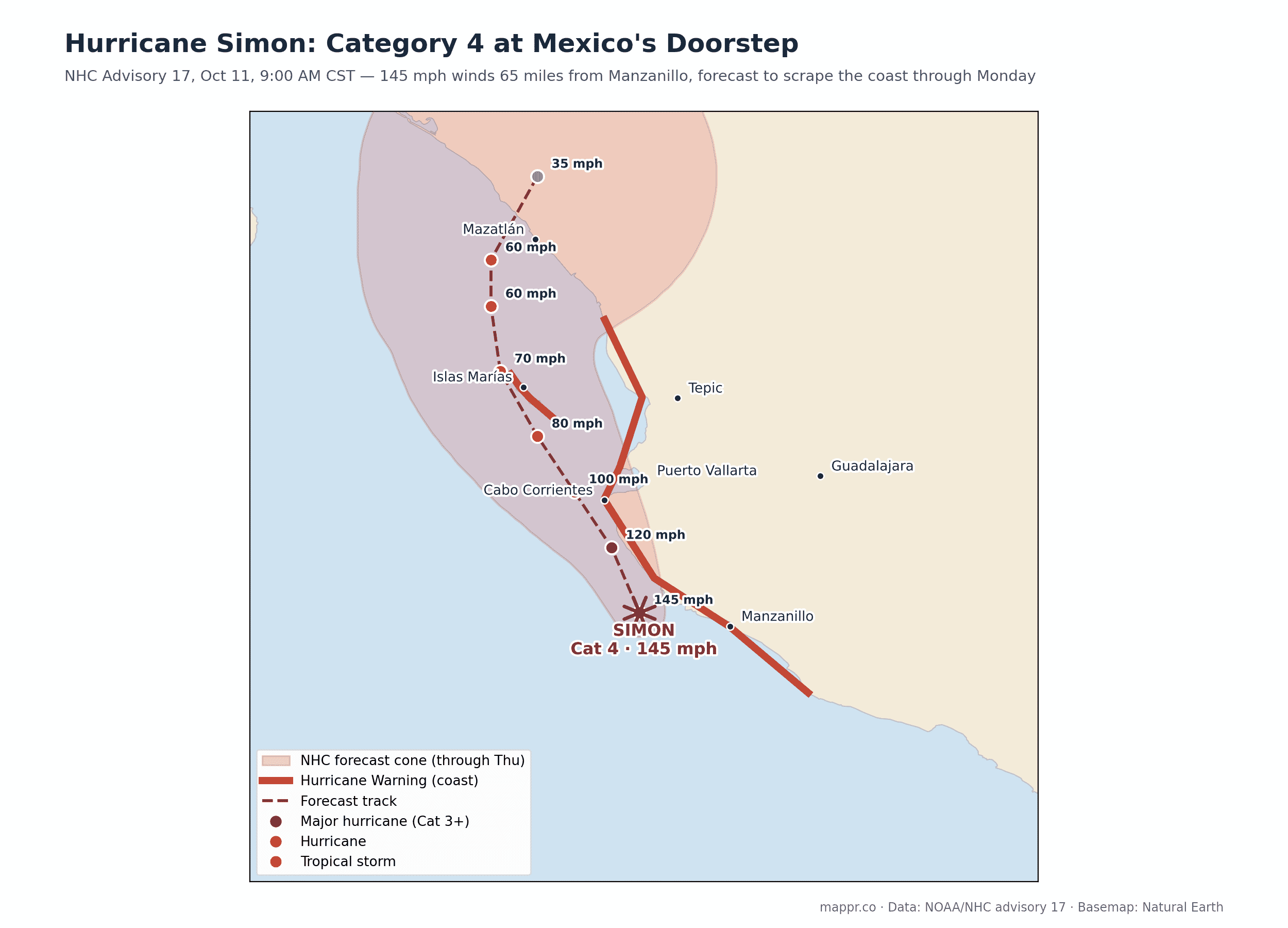
The track matters more than the category here. Simon’s hurricane-force winds reach only 25 miles from its center, but the forecast line runs parallel to the shore at roughly that distance: the difference between a catastrophic landfall and a close brush is a wobble of 20 miles. The cone carries it past Cabo Corrientes and Puerto Vallarta tonight into Monday, over or near the Islas Marias as a hurricane, then toward the Nayarit and Sinaloa coast as a weakening tropical storm by midweek.
Warnings and Hazards
🔴 Hurricane Warning: Punta San Telmo to El Roblito, and the Islas Marias. Hurricane conditions are already beginning in the south of the warning area.
🌧️ Rainfall: an additional 8 to 16 inches (200-400 mm) across southwestern Mexico, with isolated storm totals near 30 inches (750 mm) in Michoacan, Colima and Jalisco. In this terrain that means flash floods and mudslides, historically the biggest killers in Pacific-coast hurricanes.
🌊 Storm surge: dangerous surge with large, destructive waves along the immediate coast near and east of wherever the center comes closest.
An Uncomfortably Familiar Track
If this map looks familiar, it should: Hurricane Polo ran nearly the same gauntlet in late September, skirting Guerrero, Michoacan and Colima as a Category 5. Two major hurricanes threatening the same 300-mile stretch of coast within two weeks is exactly the kind of exposure that puts Mexico fifth in the world on the 2026 WorldRiskIndex, the highest exposure score of any top-five country.
The eastern Pacific season has now produced four major hurricanes, with Simon the strongest to directly threaten the Mexican mainland this year. We will update this page as Simon makes its closest approach.
Data and reporting for this article come from the following sources: