Key Takeaways
- A magnitude 6.9 quake hit southern Kamchatka early on October 16. It struck at 03:35 UTC, centered 76 km northeast of Ozernovskiy, beneath the peninsula's southern tip.
- No damage, no casualties, no tsunami, and the reason is 135 kilometers of rock. The quake ruptured deep inside the subducting Pacific plate. USGS issued its lowest 'green' impact alert, and Russian authorities reported no destruction.
- Depth is why this M6.9 was news for an hour and the 2025 M8.8 made history. Fifteen months ago the same subduction zone produced a shallow magnitude 8.8 offshore, the sixth-strongest earthquake ever recorded, with a Pacific-wide tsunami.
- Kamchatka sits on Earth's most violent subduction corner. The Pacific plate dives under the peninsula at about 8 cm a year along the Kuril-Kamchatka Trench, feeding both its volcanoes and its mega-quakes.
At 3:35 in the morning UTC on Thursday, the ground under southern Kamchatka jolted: a magnitude 6.9 earthquake, centered 76 km northeast of the small fishing town of Ozernovskiy. A 6.9 is a serious number anywhere on Earth. And yet, hours later: no reported damage, no casualties, no tsunami warning. This map is about why.
The Map: Two Quakes, Two Fates
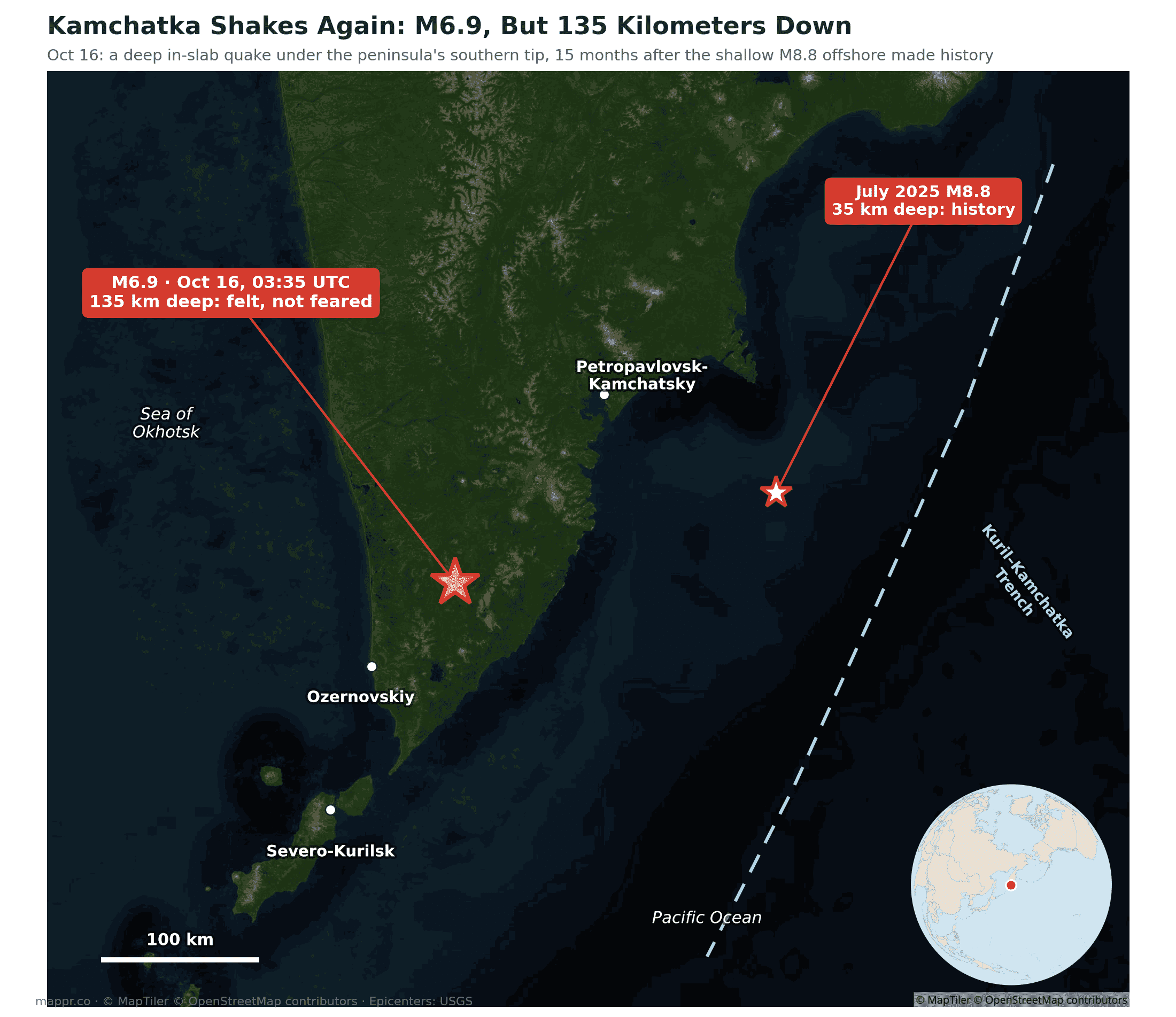
The yellow star is Thursday’s quake, 135 kilometers below the surface, inside the slab of Pacific plate that is diving under Kamchatka. The white star is its famous neighbor: the July 2025 magnitude 8.8, which ruptured at just ~35 km depth offshore and entered the all-time top ten, sending tsunami waves across the Pacific.
Why Nothing Broke
Earthquake damage is mostly a function of how close the rupture is to the surface, not just magnitude. A rupture 135 km down has to push its energy through a hundred-plus kilometers of rock before it reaches anyone’s kitchen; by the time it arrives the shaking is spread wide and thin. These intermediate-depth, in-slab quakes are felt across huge areas (residents reported rattling as far as Petropavlovsk-Kamchatsky, 180 km away) but rarely wreck buildings, and because the seafloor barely moves, they do not generate tsunamis. The USGS impact model agreed: green alert, its lowest tier, within the hour.
Flip the parameters and you get 2025: an 8.8 at 35 km under the seafloor, close enough to heave the ocean itself. Same trench, same colliding plates, opposite outcomes. It is the cleanest natural experiment in why “how big” matters less than “how deep and where”.
The Most Violent Corner of the Ring of Fire
Kamchatka earns its reputation: the Pacific plate converges here at roughly 8 centimeters a year, among the fastest subduction rates on Earth, stacking up the strain that feeds the peninsula’s 29 active volcanoes and a catalogue of giants (1952’s M9.0, 2025’s M8.8). Thursday’s M6.9 is routine bookkeeping for this margin: the slab flexing and snapping deep below as it sinks. The region has stayed restless since 2025’s mega-quake, and seismologists expect that to continue, mostly, as this week showed, harmlessly.
No update hook needed on this one: barring surprises in late damage reports, this story is complete.
Data and reporting for this article come from the following sources: