
Key Takeaways
- Thirteen weeks, and over. A stubborn "Omega block" heat dome began building over the central U.S. on 25 June. After scorching the East and pivoting west, the pattern rebuilt over the Great Basin and Plains on 12 July, setting all-time records in Billings and Salt Lake City and putting more than 125 million Americans under heat alerts in a second surge.
- The East peaked 2 to 3 July. Central Park hit 100°F (38°C) on Thursday 2 July, its first 100-degree day since 2012 and a tie with the 1966 daily record. Washington DC crossed 100°F, LaGuardia had its hottest midnight reading on record (94°F / 34°C), and heat indices along I-95 topped out at 105 to 111°F (41 to 44°C).
- Deadly, and the toll is still growing. New Jersey alone officially recorded 22 heat-related deaths over the July 4 weekend. Additional deaths have been confirmed in Illinois, and the national tally is climbing as investigations continue.
- A violent break in the East. Saturday 4 July delivered more than 540 damaging wind reports from the Plains to the Northeast (peak 92 mph at Norman, Oklahoma) as the dome began collapsing east. Fireworks were widely cancelled, but the extreme East heat ended shortly after.
- Round three: the Plains. After rebuilding on 12 July, the dome surged back over the northern Plains on 19 July, with major heat risk stretching into the lower Missouri and Mississippi valleys through 21 July and highs from the mid-90s to lower 100s°F (35 to 40°C). By 27 July it is the strongest heat dome on the planet, its core running from the Dakotas to Texas, with more than 100 million people under heat alerts, highs above 100°F (38°C) from Dallas to North Dakota and record-challenging temperatures possible in more than 30 states. By 30 July the dangerous heat still blankets the southern U.S. and is expanding into the Southwest, Intermountain West and northern High Plains, with Las Vegas above 110°F (43°C) for a sixth straight day and Phoenix, Death Valley and southern California forecast at 118 to 120°F (48 to 49°C). Two days of training storms gave Albany, New York its biggest two-day rainfall on record, and a Flash Flood Emergency sent debris flows off the Aspen Acres burn scar in Colorado, destroying at least five homes. By 31 July the core has settled over the Southwest at 110 to 120°F (43 to 49°C), with Death Valley forecast at 126°F (52°C), Billings and Salt Lake City near 106°F (41°C) on Saturday and about 40 million people under heat alerts. NOAA keeps major to extreme heat over the Southwest and Intermountain West into midweek, then re-intensifying over the central High Plains. On 1 August the Southwest peak arrives with Death Valley near 125°F (52°C) and Las Vegas and Phoenix above 115°F (46°C), while the dry cold front behind the ridge puts central and eastern Washington and northern Oregon under Extremely Critical fire weather and what is reported as the first Particularly Dangerous Situation red flag warning ever issued for Washington state. On 2 August the heat peaks with Phoenix near 116°F (47°C) and more than 50 million people under heat alerts, while the fire warning turns real: the Old Trails fire crosses the Spokane River into Spokane, burns 3,509 acres with no containment, destroys dozens of homes and forces thousands to evacuate, prompting a Washington statewide emergency and the activation of 110 National Guard members. On 3 August daylight puts the loss at 640 structures destroyed by Old Trails alone, about 60,000 people under evacuation orders and the three Spokane fires merged into one complex at zero containment, with incident commanders calling it probably the most destructive fire in Washington history; Phoenix broke its 2 August record at 115°F (46°C), extreme heat warnings now run into Wednesday, and NIFC counts 99 uncontained large fires with 5,275,247 acres burned nationally in 2026. On 4 August investigators ruled the Old Trails fire arson and arrested a 37-year-old Spokane man on a $1 million bond, while the loss estimate widened to 700 to 1,100 structures and 67,000 evacuees, the Sinlahekin fire near Tonasket doubled to 73,794 acres, Oregon passed 2,014,481 acres and closed on its 2024 record of 2,081,661, and the Phoenix and Las Vegas heat warnings were extended to Friday and Saturday. On 5 August President Trump approved a federal emergency declaration for Washington covering six counties and three tribes at a 75% federal cost share, all 14 people the sheriff had been trying to reach were confirmed safe with no deaths reported, the Spokane Area Fires passed 10,000 acres at zero containment as Autumn Lane grew 2,252 acres to 5,603, the Sinlahekin fire near Tonasket jumped another 29,140 acres to 102,934 at 5% containment, NIFC counted 99 uncontained large fires and 45,050 fires for 5,253,328 acres nationally, and the Phoenix extreme heat warning was pushed back again to 8 p.m. Sunday 9 August while Heat Advisories returned to western Washington and northwest Oregon. On 6 August the Spokane Area Fires posted their first containment, 13% on Old Trails and Autumn Lane and 5% on Fairview across 10,546 acres, with NIFC giving an official 707 structures destroyed and a new Fire Weather Watch running over the same ground to Saturday night; NIFC held Preparedness Level 5 but cut uncontained large fires to 94, with 45,184 fires for 5,465,682 acres nationally, 143% of the 10-year average, while the Sinlahekin fire reached 117,078 acres, the Little Giant fire near Leavenworth 70,853 at zero containment, and Oregon was reported past its 2024 acreage record; NWS Phoenix moved the heat peak to Saturday at 110 to 116°F (43 to 47°C) with feels-like values near 120°F (49°C), and Las Vegas and northern Nevada were both extended or upgraded through Sunday. By 10 August the Southwest heat is past its peak but not gone: the Extreme Heat Warning was extended a day to 8 p.m. Monday for the Phoenix metro, the Las Vegas Valley, Death Valley and the Colorado River Valley, with lower-desert highs of 108 to 112°F (42 to 44°C), heat index values of 115 to 118°F (46 to 48°C) in southeast California, Las Vegas at 109°F (43°C) and Death Valley near 125°F (52°C), before near-seasonal readings arrive on Tuesday with monsoon moisture at 150 to 200% of normal. In Spokane the sheriff shrank the evacuation zones on 9 August, dropping most of the fire area to Level 1 and letting thousands return while the burn path stays at Level 3, and the NIFC report for 9 August put Autumn Lane at 61% contained, Old Trails at 43% and Fairview at 43% across 10,002 acres with no reported deaths. Nationally NIFC held Preparedness Level 5 with 94 large uncontained fires and 30,419 personnel, and counted 45,872 fires for 6,328,055 acres this year against 3,604,307 acres at the same point in 2025, while WPC moved the hazardous heat to the southern Plains, Gulf Coast and Southeast for 13 to 17 August. By 11 August the Southwest is out of it: every Extreme Heat Warning in Arizona, southern Nevada and southeast California has expired, and NWS Phoenix sees no extreme heat for at least seven days as monsoon storms and flash flooding take over. The hazard has set up over the middle of the country instead, with four Extreme Heat Warnings across central and eastern Missouri, southeast Kansas and southern Illinois at heat index values up to 113°F (45°C), 40 Heat Advisories from the High Plains to Florida, and a WPC protracted heatwave from the south-central to the southeastern U.S. through 18 August. In Spokane the NIFC report for 10 August put Autumn Lane at 73% contained, Old Trails at 53% and Fairview at 53% across 9,944 acres, with more than 1,700 firefighters assigned, 921 structures destroyed and no deaths, and Governor Bob Ferguson said he will seek a Major Disaster Declaration to unlock individual assistance. The Little Giant fire near Lake Chelan destroyed 26 structures in the upper Entiat Valley and reached 111,429 acres at 2% containment, and nationally NIFC held Preparedness Level 5 with 98 large uncontained fires, 29,840 personnel and 46,064 fires for 6,354,141 acres this year against 3,623,392 acres at the same point in 2025. By 13 August the heat has widened rather than eased: 17 Extreme Heat Warnings and 43 Heat Advisories now stretch from Kansas and Oklahoma across the mid-South to the Georgia, South Carolina and Florida coasts, with NWS Paducah, Little Rock, Memphis and Springfield all warned to Sunday evening at heat index values of 105 to 115F, and NWS Little Rock saying the Little Rock area record of 15 consecutive 100-degree days, set in 1980, could be broken. NWS Phoenix ended its own lull early by issuing an Extreme Heat Watch for the Phoenix metro from Monday 17 to Wednesday 19 August at 108 to 112F. In Spokane the NIFC report for 12 August lifted Old Trails to 83% contained alongside Autumn Lane at 89% and Fairview at 97% across 9,932 acres, assigned personnel fell to 407, and crews moved to urban mop-up as the Disaster Assistance Center closed, with no deaths reported. Nationally NIFC held Preparedness Level 5 with 101 large uncontained fires and 46,509 fires for 6,447,442 acres this year, while the Little Giant fire grew to 122,401 acres and reached 5% containment. By 14 August the alert map has narrowed to 13 Extreme Heat Warnings and 41 Heat Advisories across the lower 48 while the warnings themselves run longer, with NWS Tulsa joining and Paducah, Little Rock, Memphis and Springfield all warned to Sunday evening; NWS Phoenix widened its Extreme Heat Watch for Monday to Wednesday to cover Maricopa and Pinal counties and NWS Tucson issued one of its own, and CPC raised the central and southern Plains and the middle and lower Mississippi Valley to a high risk of extreme heat on 21 August with rapid-onset drought flagged alongside it. The NIFC report for 13 August put Old Trails, Autumn Lane and Fairview all at 97% contained across 9,932 acres with 407 personnel and an estimated containment date of 15 August, recorded the death of a contract firefighter on the Bear Trap incident in Minnesota on 11 August, and counted 95 large uncontained fires nationally and 46,636 fires for 6,485,336 acres this year, 154% of the ten-year average for acres. On 15 August the South took over: NWS Nashville and NWS New Orleans joined the warned list at 15 Extreme Heat Warnings and 39 Heat Advisories, NWS Little Rock pushed Arkansas out to 8 p.m. Monday, and NWS Phoenix stretched its Extreme Heat Watch to Friday 21 August at 109 to 113°F (43 to 45°C) in the metro. NIFC’s 14 August report held the three Spokane fires at 97% contained across 9,932 acres while personnel fell from 407 to 237, and counted 93 large uncontained fires and 48,469 fires for 6,549,122 acres this year, 155% of the ten-year average for acres. On 18 August the heat widened west and south again to 18 Extreme Heat Warnings across 13 states and 35 Heat Advisories with no watches left: NWS Fort Worth warned North Texas to 108F, NWS Norman warned Oklahoma at heat index values to 109F and NWS Tulsa ran to 9 p.m. Wednesday at 112F, while NWS Las Vegas upgraded to a warning at 115 to 118F through Death Valley and NWS Flagstaff warned the lower Grand Canyon, Phoenix and Tucson holding to 8 p.m. Friday. Red Flag Warnings returned to the Northwest for the Lower Palouse and the Lower Columbia Basin, and NIFC’s 17 August report lifted Old Trails to 98% contained, dropped the contained Fairview from its table, marked both remaining Spokane fires last report, and counted 80 large uncontained fires and 48,960 fires for 7,270,038 acres this year, 169% of the ten-year average for acres. On 19 August the map pulled back to 17 Extreme Heat Warnings across eight states and 38 Heat Advisories as Alabama, Mississippi, Louisiana, Florida, Georgia and the Carolinas fell to advisories and every Red Flag Warning expired, while NWS Tulsa called Wednesday the hottest day of the year for most of eastern Oklahoma at above 105°F (41°C) and NWS Little Rock forecast Little Rock at 108°F (42°C) with record highs possible; NIFC’s 18 August report dropped Old Trails, Autumn Lane and Fairview from its table entirely, the formal end of the Spokane Area Fires nationally, cut uncontained large fires to 76 and counted 49,242 fires for 7,278,622 acres this year, and Governor Bob Ferguson and Representative Michael Baumgartner wrote to President Trump seeking a meeting on Washington’s coming Major Disaster Declaration request. On 20 August the warned map narrowed again to 14 Extreme Heat Warnings across six states as a front pulled the mid-South out, a day after Little Rock set a record at 107°F (42°C), while NWS Phoenix extended its warnings to Sunday, the southern California deserts went to a warning and CPC flagged a high risk of extreme heat for 27 to 29 August. On 21 August NWS Phoenix pushed that warning far further out, to 8 p.m. Friday 28 August, at 108 to 114°F (42 to 46°C) in the metro and 106 to 116°F (41 to 47°C) in southwest Arizona and southeast California, while the Gulf Coast went back under warnings from New Orleans, Lake Charles, Jackson and Shreveport at heat index values of 113 to 115°F (45 to 46°C), holding the national count at 14 Extreme Heat Warnings but across eight states with 39 Heat Advisories; Little Rock set a second straight daily record at 106°F (41°C) before reaching 102F again on 21 August with its run of 100-degree days still going, three Red Flag Warnings and 14 Fire Weather Watches put fire weather back over the Northwest for Saturday into Sunday, NIFC’s 20 August report cut uncontained large fires to 72 and counted 49,608 fires for 7,510,237 acres this year, and CPC moved its high risk of extreme heat to 28 to 29 August and expanded it across Texas and the Lower Mississippi Valley. On 22 August the warned map collapsed to nine Extreme Heat Warnings across four states, Arizona, California, Nevada and Texas, with 23 Heat Advisories in the lower 48 and no watches, as the Gulf Coast warnings from New Orleans, Lake Charles, Jackson and Shreveport all expired and those offices fell back to advisories at heat index values up to 112F. NWS Phoenix put a 599 dam high near the Four Corners with 596 to 598 dam overhead, at or above the 99th percentile of sounding climatology, and forecast highs of 110 to 116F within a few degrees of daily records through the weekend and 110F or better nearly every day through Friday, while NWS Las Vegas warned to Sunday at 115 to 118F and NWS San Diego pushed the California deserts to 28 August at up to 115F. The forecast Northwest fire weather then arrived, with 20 Red Flag Warnings across Washington, Oregon, Idaho, northern California and Nevada and NWS Spokane warning of a strong cold front bringing thunderstorms and 50 mph outflow gusts to the ground that burned this month; the Little Giant fire reached 140,379 acres at 15% containment with 2,303 personnel, Sinlahekin held at 154,298 acres and 47%, and NIFC counted 76 uncontained large fires, up from 72, and 50,077 fires for 7,642,082 acres this year, 171% of the ten-year average for acres.
- The Southwest ends, the Midwest takes over. The last Extreme Heat Warnings in the country, covering Arizona and California, expired at 8 p.m. on Saturday 29 August and were not renewed, leaving NOAA with no Extreme Heat Warnings or Watches anywhere in the lower 48 and only three Heat Advisories, all in Oklahoma and the Texas Panhandle. Phoenix signed off at 113F (45C) and Las Vegas at 105F (41C), and Arizona flipped straight to Flood Watches for monsoon storms. NIFC counted 92 uncontained large fires and 51,774 fires for 8,107,724 acres this year, 165% of the ten-year average, while the Plaskett fire on the Big Sur coast grew to 8,241 acres with no containment. WPC then pushed the dangerous heat east to the Plains, Midwest, Mid-Atlantic and Southeast for 2 to 6 September. On 31 August that shift arrived: Heat Advisories jumped from three to 16 across the Midwest and mid-South, from central Iowa and northeast Kansas to Mississippi and west Tennessee at heat index values of 100 to 109F, with NWS St. Louis, Springfield and Paducah warned to 8 p.m. Friday 4 September and NWS St. Louis calling it a prolonged regional heatwave with near-record warmth. The Southwest cooled hard behind it, Phoenix to 106F (41C) and Las Vegas to 101F (38C) with Flood Watches for monsoon rain across Arizona, while NIFC’s 30 August report pushed uncontained large fires back up to 98 and counted 51,961 fires for 8,221,246 acres this year, 163% of the ten-year average, with Plaskett at 8,241 acres and 1% containment on the Big Sur coast. On 1 September the heat jumped the Mississippi: Heat Advisories doubled from 16 to 28 across 17 states as the 596 dam upper high settled over the Ohio River Valley, reaching Cleveland, Louisville, Charleston, Indianapolis and Chicago at heat index values of 100 to 110F and Philadelphia, northern Delaware and southern New Jersey for the first time this round, with NWS St. Louis, Springfield, Paducah and Kansas City warned to 8 p.m. Friday 4 September. Phoenix fell to 91F, 13 degrees below normal, and Arizona dropped its Flood Watches as Tropical Storm Edouard closed on the upper Texas coast. NIFC recorded a federal wildlife officer killed while helping residents evacuate the Railroad South fire near Indiahoma, Oklahoma, named locally as David Taylor, 38, and on the Big Sur coast Plaskett exploded to 26,734 acres at 1% containment, overtaking Timber at 25,190 acres at 22%, while Little Giant jumped to 49% containment and NIFC counted 93 uncontained large fires and 52,253 fires for 8,238,284 acres this year, 166% of the ten-year average. On 2 September the Extreme Heat Warnings returned, two of them in the mid-Mississippi Valley from NWS Paducah, to 8 p.m. Saturday 5 September at heat index values of 103 to 109F, and NWS Quad Cities, to 7 p.m. Friday 4 September at up to 105F, the first anywhere in the country since 29 August, with 52 Heat Advisories behind them, 51 in the lower 48 across 22 states. The eastern edge slid south as Philadelphia dropped out and Virginia, the Carolinas and north Georgia came in, the NWS Chicago site at Romeoville tied its 1 September record at 93F (34C), and NIFC counted 87 uncontained large fires and 52,466 fires for 8,262,025 acres this year, 164% of the ten-year average, while Plaskett on the Big Sur coast reached 27,580 acres at 1% containment and Timber held at 25,223 acres at 22%. On 3 September the Midwest warning count tripled to seven Extreme Heat Warnings with 54 Heat Advisories behind them, 53 in the lower 48 across 25 states, NWS St. Louis warned the metro to 8 p.m. Saturday 5 September at heat index values up to 110F (43C) and NWS Chicago warned all three Cook County zones for a single day at 100 to 105F, while Laredo hit 107F (42C) and Raleigh 100F (38C), both past marks set in 1912. On 4 September the warnings rose again to 10 across six states, Iowa, Illinois, Indiana, Kansas, Kentucky and Missouri, as the advisories fell from 54 to 45: NWS Topeka warned central and northeast Kansas to 7 p.m. Tuesday 8 September at heat index values of 100 to 107F on a seventh straight 100-degree heat index day, NWS Kansas City upgraded its whole area through Saturday and pushed the ground south of a St. Joseph to Boonville line to 8 p.m. Tuesday, and NWS St. Louis flagged near-record heat returning by Wednesday under a 500 hPa ridge it expects to be record breaking in strength for early September. Laredo set a second straight record at 108F (42C), McAllen tied 2011 at 106F, and record warm lows ran from Lincoln, Nebraska at 79F (26C) and Russell, Kansas at 79F (26C) to Columbus at 75F and Charlotte at 76F, while CAL FIRE lifted the Plaskett fire on the Big Sur coast to 29,702 acres and 19% containment, its first real progress after a week at 1%, and NIFC counted 78 uncontained large fires and 52,767 fires for 8,272,749 acres this year, 161% of the ten-year average. On 5 September the count reached 11 Extreme Heat Warnings across the same six states as the advisories fell to 34, 33 in the lower 48 across 17 states: NWS Springfield upgraded its whole area to a warning to 8 p.m. Sunday 6 September at heat index values up to 110F, with HeatRisk maxed out in the Extreme category, NWS St. Louis reissued the metro warning up to 110F and NWS Topeka held Kansas to 7 p.m. Tuesday at 100 to 108F. Friday moved the records east, Danville at 102F and Lynchburg at 100F past 1925 marks, Cincinnati at 97F and Lexington at 98F, with record warm lows at St. Louis (81F), Louisville (78F) and Chicago O’Hare (76F). NIFC lowered the National Preparedness Level from 5 to 4, cut uncontained large fires to 77 and counted 52,939 fires for 8,296,949 acres this year, 160% of the ten-year average, while CAL FIRE lifted Plaskett to 29,768 acres and 23% containment. On 6 September the wave breaks: NOAA lists six Extreme Heat Warnings against 11, only five in the lower 48 and across three states, Kansas, Missouri and Arkansas, while Heat Advisories halve from 34 to 20. Illinois, Indiana, Iowa and Kentucky all fall out, NWS St. Louis drops the metro to a Heat Advisory, and the highest figure in the country is a 112F heat index in western Arkansas, with NWS Topeka and NWS Kansas City holding Kansas and the metro to Tuesday 8 September. Saturday was hot without records, St. Louis at 101F and Salina and Tulsa at 103F, while behind the backdoor front Chicago managed only 81F. NIFC held Preparedness Level 4 with 78 uncontained large fires and 53,030 fires for 8,307,707 acres this year, 159% of the ten-year average by acreage, and CAL FIRE lifted Plaskett to 29,831 acres and 31% containment. On 7 September the Southwest takes it back: NWS Phoenix issued five Extreme Heat Warnings at 12:33 a.m. MST, the first in Arizona and southeast California since 29 August, covering the Phoenix metro at 105 to 109F from Tuesday to 8 p.m. Thursday 10 September and Imperial County, California at 106 to 112F to 8 p.m. Friday 11 September, on 500 mb heights rising to 594 to 597 dam by early Wednesday, near record strength for the date. That lifts the national count to nine Extreme Heat Warnings against six, eight of them in the lower 48 across four states, while Heat Advisories fall from 20 to 13. The Midwest round ends midweek instead, with NWS Topeka and NWS Kansas City warned to Tuesday and a cold front due Tuesday evening into Wednesday, after Sunday ended the record lull at Springfield, Missouri 101F, Joplin 104F, Batesville, Arkansas 105F, Hot Springs and Stuttgart 104F and Fayetteville 103F. Southern California set daily rainfall records instead, at downtown Los Angeles (0.70 inches), LAX (0.59) and Burbank (1.30) on moisture from Hurricane Marie. NIFC held Preparedness Level 4, cut uncontained large fires to 75 and counted 53,165 fires for 8,302,657 acres this year, 158% of the ten-year average, while CAL FIRE lifted Plaskett to 29,862 acres and 37% containment. On 8 September the heat expands instead of fading: NOAA lists 12 Extreme Heat Warnings against nine, all of them in the lower 48 across seven states, and Heat Advisories more than double from 13 to 30. NWS Las Vegas warns Death Valley and the Colorado River Valley at 112 to 116F and NWS San Diego warns the Coachella Valley at up to 110F to 8 p.m. Friday 11 September, while California goes under Heat Advisories from the Bay Area and Sacramento Valley through the San Joaquin Valley to the Los Angeles basin, where NWS Los Angeles/Oxnard calls humidity extreme and gives a 20 to 30% chance of an upgrade to a warning. NWS Phoenix moves the peak to Thursday at 106 to 110F with heat indices of 108 to 117F. Monday set records from the Pacific to the Gulf: San Diego 95F, breaking a 1949 mark in a record that begins in 1875, Salina 105F, Fort Smith 105F, McAllen 105F, Wichita 104F and El Dorado, Arkansas 103F. NIFC cut uncontained large fires to 66 and counted 53,233 fires for 8,303,398 acres this year, 156% of the ten-year average for acres, while CAL FIRE lifted Plaskett to 47% containment. On 9 September California took over: NOAA listed 16 Extreme Heat Warnings, 12 of them taking in part of California, NWS Los Angeles/Oxnard upgraded the LA basin to 88 to 108F, and Wednesday broke records at Escondido (112F, in a record that begins in 1893), Santa Ana (108F), Long Beach (107F), downtown Los Angeles (105F) and San Rafael (104F). On 10 September the heat pulls back to the Southwest: 15 Extreme Heat Warnings remain, all in the lower 48 and across only Arizona, California and Nevada, Heat Advisories collapse from 26 to six, the coastal warnings expire at 8 p.m. Thursday with extensions called unlikely, and NIFC cuts the national preparedness level from 4 to 3 with 59 uncontained large fires and 8,404,094 acres burned nationally this year. By 17 September every Extreme Heat Warning in the country has expired and the hazard is down to 14 Heat Advisories across ten states in the mid-South and lower Ohio Valley, where Nashville tied its 2019 record at 99F on Wednesday in a series that begins in 1871, Stuttgart, Arkansas broke a 1997 and 2019 mark at 101F and Springfield, Missouri broke a 1980 mark at 98F. The fire season moved south with the ridge: NIFC makes the Southern Area the top-priority geographic area with nine new large incidents, Texas alone has seven large fires for 112,852 acres, and the national count is 61 uncontained large fires and 56,042 fires for 8,514,803 acres this year. WPC has the persistent ridge over the South breaking down this weekend and CPC posts no heat hazards for 24 to 30 September. It ended there: the last lower-48 Heat Advisories expired at 8 p.m. on 20 September, and on 24 September NOAA carries no Extreme Heat Warnings, no Extreme Heat Watches and no Heat Advisories anywhere in the country, with NIFC down to national preparedness level 2 and 30 uncontained large fires.
This tracker followed a single heat dome from 25 June to late September, and it is now over. A massive heat dome, what meteorologists sometimes call a “death ridge,” first built over the central United States ahead of the Fourth of July weekend, then rebuilt twice over the interior West and Plains.
It ended in the week to 24 September. NOAA’s active list carries no Extreme Heat Warnings, no Extreme Heat Watches and no Heat Advisories anywhere in the country.
The last products expired on Sunday. The final lower-48 Heat Advisories ran out at 8 p.m. on 20 September across the Ohio Valley and mid-South, and Puerto Rico’s last one at 3 p.m. on Monday.
Some ridge warmth is left in the south. WPC’s 24 September discussion keeps highs in the 90s°F (32 to 37°C) over the southern Plains and Lower Mississippi Valley into early next week, then moderates the Plains by midweek.
Nothing hazardous is posted ahead. The same discussion leads on a coastal storm in the Northeast and widespread rain in the Four Corners and Plains, with the West cooler than average.
The fire season is winding down with it. NIFC’s 23 September report cuts the national preparedness level to 2 and drops uncontained large fires to 30, with 8,523 personnel assigned.
California has the live one. The Dome fire in Yosemite is at 3,989 acres and 15% containment north of Wawona Dome, with the park open and the Chilnualna Falls Trail closed.
Texas and Oklahoma have eased. Rain fell over the Hydra and Gracemont fire areas, and the Southern Area is down to four uncontained large fires from 15 a week ago.
As of 17 September the top tier of the alert map is empty. NOAA’s active list carries no Extreme Heat Warnings and no Extreme Heat Watches anywhere in the country, against 15 warnings a week ago.
The hazard has moved to the mid-South. 14 Heat Advisories run across ten states, from southeast Kansas and Oklahoma through Missouri, Arkansas, Illinois, Indiana, Kentucky and Tennessee to north Mississippi and north Alabama.
The records are still falling. Nashville reached 99°F (37°C) on Wednesday, tying its 2019 mark in a record that begins in 1871, and Memphis hit 98°F (37°C), 13 degrees above normal.
Arkansas and Missouri broke theirs outright. Stuttgart reached 101°F (38°C) and Batesville 100°F (38°C), both past 1997 and 2019 marks, while Springfield, Missouri hit 98°F (37°C) past a 1980 record.
The Southwest has flipped completely. NWS Phoenix has a Flood Watch over much of southern Arizona, below-normal temperatures and widespread monsoon storms, with a Flash Flood Warning out of NWS Tucson.
The fire map moved south with the ridge. NIFC’s 16 September report makes the Southern Area the highest-priority geographic area, with nine new large incidents, and counts 61 uncontained large fires nationally.
Texas took most of them. The state now has seven large fires for 112,852 acres, five of them new, including Dry River near Sonora at 3,500 acres and no containment.
The end of the pattern is in sight. WPC has the persistent ridge over the South breaking down this weekend, and CPC posts no heat hazards at all for 24 to 30 September.
As of 10 September the heat has pulled back to the Southwest. NOAA lists 15 Extreme Heat Warnings against 16 yesterday, all of them in the lower 48, and they now sit in only three states: Arizona, California and Nevada.
Nothing is left east of Arizona. NWS Tulsa’s warning has expired, and Heat Advisories have collapsed from 26 to six across four states, four of them in California and two in the mid-South.
California still holds 12 of the 15. NWS Los Angeles/Oxnard and NWS San Diego run their warnings to 8 p.m. Thursday, and the Oxnard office calls extensions unlikely, with big drops Friday and Saturday as the marine layer returns.
Wednesday was the record day. Long Beach hit 107°F (42°C) past 103°F from 2015, downtown Los Angeles tied its 2024 mark at 105°F (41°C) and Paso Robles tied 1993 at 106°F (41°C).
San Diego County went further. Escondido reached 112°F (44°C), past 104°F from 2024 in a record that begins in 1893, with Santa Ana at 108°F (42°C) and Anaheim at 107°F.
The fire season steps down. NIFC’s 9 September report cuts the national preparedness level from 4 to 3 and drops uncontained large fires to 59, with 53,802 fires for 8,404,094 acres burned nationally this year.
As of 9 September California is the front line. NOAA lists 16 Extreme Heat Warnings against 12 yesterday, all of them in the lower 48 across five states, and 12 of the 16 take in part of California.
Los Angeles made the upgrade. NWS Los Angeles/Oxnard lifted its advisories to an Extreme Heat Warning at 88 to 108°F (31 to 42°C) to 8 p.m. Thursday, and NWS San Diego warned the coast, the valleys and the Inland Empire to 8 p.m. tonight.
The Midwest round is over. Kansas and Missouri are out of warnings entirely and Heat Advisories fell from 30 to 26, leaving NWS Tulsa at 112°F (44°C) as the only warning outside the West.
Tuesday broke records across the middle. Salina tied 1922 at 106°F (41°C), Concordia reached 106°F, Fort Smith 105°F and Oklahoma City 103°F (39°C).
The fires keep easing. Plaskett jumped to 61% containment, and NIFC cut uncontained large fires to 64 with 8,397,760 acres burned nationally this year.
As of 8 September the heat is spreading rather than fading. NOAA lists 12 Extreme Heat Warnings against nine yesterday, all of them in the lower 48 across seven states, while Heat Advisories more than double from 13 to 30.
Two offices joined overnight. NWS Las Vegas warns Death Valley and the Colorado River Valley at 112 to 116°F (44 to 47°C), and NWS San Diego warns the Coachella Valley at up to 110°F (43°C) from Wednesday.
California is the new front. Heat Advisories now run from the Bay Area and the Sacramento Valley through the San Joaquin Valley to the Los Angeles basin, Wednesday into Thursday night.
Monday broke records from the Pacific to the Gulf. San Diego hit 95°F (35°C), past a 1949 mark in a record that begins in 1875, while Salina, Fort Smith and McAllen all reached 105°F (41°C).
The Midwest round ends tonight. Kansas, the Kansas City metro and southwest Missouri all expire this evening, while NWS Tulsa holds the highest warning figure in the country at 112°F (44°C).
The fires keep easing. Plaskett reached 47% containment, and NIFC cut uncontained large fires to 66 with 8,303,398 acres burned nationally this year.
As of 7 September the Southwest takes it back. NOAA lists nine Extreme Heat Warnings against six yesterday, eight in the lower 48 across four states, while Heat Advisories fall from 20 to 13.
NWS Phoenix issued five of them overnight, the first in Arizona and southeast California since 29 August. The Phoenix metro is warned from Tuesday to 8 p.m. Thursday at 105 to 109°F (41 to 43°C), Imperial County to Friday at 106 to 112°F (41 to 44°C).
The Midwest round ends midweek. Kansas and the Kansas City metro stay warned to Tuesday, a cold front follows Tuesday evening into Wednesday, and St. Louis is out of heat products entirely.
Sunday broke records again after a day without. Springfield, Missouri hit 101°F (38°C), Joplin 104°F (40°C) and Batesville, Arkansas 105°F (41°C), past marks from 1960, 1954 and 1939.
Southern California got rain instead. Moisture from Hurricane Marie set daily rainfall records at downtown Los Angeles, LAX and Burbank, and Barstow-Daggett set a record cold high of 77°F (25°C).
The fires keep easing. Plaskett reached 29,862 acres and 37% containment, and NIFC cut uncontained large fires to 75 with 8,302,657 acres burned nationally this year.
As of 6 September the wave is breaking. NOAA lists six Extreme Heat Warnings against 11 yesterday, only five in the lower 48 and across three states, with Heat Advisories halved from 34 to 20.
Illinois, Indiana, Iowa and Kentucky are out of it. NWS St. Louis dropped the metro to a Heat Advisory, and what is left runs from Kansas and Missouri into western Arkansas, where NWS Tulsa warns of a heat index up to 112°F (44°C).
Kansas and Kansas City hold on. Both NWS Topeka and NWS Kansas City keep Extreme Heat Warnings to Tuesday 8 September, at heat index values of 100 to 108°F (38 to 42°C) and up to 105°F (41°C).
Saturday broke no records. St. Louis reached 101°F (38°C) and Tulsa and Salina 103°F (39°C), while behind the front Chicago O’Hare managed only 81°F (27°C).
The fires are still the slower story. Plaskett reached 29,831 acres and 31% containment, and NIFC held Preparedness Level 4 with 78 uncontained large fires and 8,307,707 acres burned this year.
As of 5 September the warned area is still growing while the advisory map shrinks. NOAA lists 11 Extreme Heat Warnings against 10 yesterday, across the same six states, with Heat Advisories down from 45 to 34.
Missouri went to warnings in full. NWS Springfield upgraded its entire forecast area to an Extreme Heat Warning to 8 p.m. Sunday 6 September at heat index values up to 110°F (43°C), calling HeatRisk maxed out in the Extreme category.
Friday moved the records east. Danville, Virginia reached 102°F (39°C) and Lynchburg 100°F (38°C), both past 1925 marks, while St. Louis never fell below 81°F (27°C) overnight.
The break is in sight. NWS St. Louis has a backdoor front crossing tonight and cooler air on Sunday and Labor Day Monday, and NIFC lowered the National Preparedness Level from 5 to 4 as Plaskett reached 29,768 acres and 23% containment.
As of 4 September the warned area keeps growing. NOAA lists 10 Extreme Heat Warnings against seven yesterday, now across six states, while Heat Advisories have fallen from 54 to 45.
Kansas is the new center of it. NWS Topeka warns central and northeast Kansas to 7 p.m. Tuesday 8 September at heat index values of 100 to 107°F (38 to 42°C), on what it calls a seventh straight 100-degree heat index day.
Kansas City extended too. NWS Kansas City upgraded its whole area to a warning through Saturday evening and took the ground south of a St. Joseph to Boonville line out to 8 p.m. Tuesday.
Thursday set more records. Laredo hit 108°F (42°C), past a 1992 mark, and Lincoln, Nebraska never dropped below 79°F (26°C), four degrees past a record set in 1937.
Big Sur turned a corner. CAL FIRE has Plaskett at 29,702 acres and 19% containment after a week at 1%, and NIFC’s 3 September report cuts uncontained large fires to 78 with 8,272,749 acres burned this year.
As of 3 September the warning count has tripled. NOAA lists seven Extreme Heat Warnings against two yesterday, all of them in the Midwest and mid-Mississippi Valley, with 54 Heat Advisories behind them.
St. Louis has the sharpest numbers. Its new warning runs to 8 p.m. Saturday at heat index values up to 110°F (43°C), while NWS Chicago warns Cook County to 7 p.m. today at 100 to 105°F (38 to 41°C).
Wednesday delivered the records. Laredo hit 107°F (42°C) and Raleigh 100°F (38°C), both past marks set in 1912, and record warm lows ran from Washington Dulles to Salina, Kansas.
The fires eased a little. NIFC’s 2 September report puts the year at 8,265,751 acres and cuts uncontained large fires to 84, though Plaskett grew again to 29,123 acres at 1% containment.
As of 2 September the Extreme Heat Warnings are back. NOAA lists two of them, the first anywhere in the lower 48 since the Arizona and California products expired on 29 August, with 52 Heat Advisories behind them.
Both warnings sit in the mid-Mississippi Valley. NWS Paducah covers southern Illinois, southwest Indiana, western Kentucky and southeast Missouri to 8 p.m. Saturday, NWS Quad Cities eastern Iowa and western Illinois to 7 p.m. Friday.
This is about duration rather than a peak. Paducah has heat index values of 103 to 109°F (39 to 43°C) with record warm overnight lows in the mid 70s°F (mid 20s°C), 10 to 15 degrees above normal, into the holiday weekend.
The advisories reach further than yesterday. 51 of the 52 are in the lower 48, across 22 states, with Virginia, the Carolinas and north Georgia added as Philadelphia and southern New Jersey dropped out.
The fires moved too. NIFC’s 1 September report puts the year at 8,262,025 acres and cuts uncontained large fires to 87, while Plaskett on the Big Sur coast has reached 27,580 acres at 1% containment.
As of 1 September the heat has jumped the Mississippi. NOAA still lists no Extreme Heat Warnings and no Extreme Heat Watches in the lower 48, but Heat Advisories have doubled from 16 to 28, across 17 states.
The Ohio Valley and Mid-Atlantic are in it now. Cleveland, Louisville, Charleston, Indianapolis and Chicago are all under advisories, and NWS Mount Holly has Philadelphia, northern Delaware and southern New Jersey warned to 8 p.m. today.
The ridge moved to do it. NWS Norman puts the center of the 596 dam upper high near the Ohio River Valley, with heat index values of 100 to 110°F (38 to 43°C) around Chicago and up to 110°F (43°C) in Mississippi.
The Southwest is fully out. Phoenix reached only 91°F (33°C) on Monday, 13 degrees below normal, and every Arizona Flood Watch has expired as Tropical Storm Edouard closes on the upper Texas coast.
The fires took a life. NIFC’s 31 August report records a federal wildlife officer killed while helping residents evacuate the Railroad South fire in Oklahoma, and on the Big Sur coast Plaskett has exploded to 26,734 acres at 1% containment.
As of 31 August the heat has rebuilt over the middle of the country. NOAA still lists no Extreme Heat Warnings and no Extreme Heat Watches in the lower 48, but Heat Advisories have gone from three to 16, from Iowa and Kansas to Mississippi and Tennessee.
The alerts now run for days rather than hours. NWS St. Louis, Springfield and Paducah are warned to 8 p.m. Friday 4 September at heat index values of 100 to 106°F (38 to 41°C), covering the whole Labor Day week.
The Southwest is out of it. Phoenix came down to 106°F (41°C) on Sunday and Las Vegas to 101°F (38°C), while Flood Watches for monsoon rain cover Arizona into Monday evening.
As of 30 August the national heat map is blank. NOAA’s active alert list carries no Extreme Heat Warnings and no Extreme Heat Watches anywhere in the lower 48, after the last Arizona and California products expired at 8 p.m. Saturday.
Three Heat Advisories are all that is left, in central, northern and northeast Oklahoma and the Palo Duro Canyon in Texas, at 105 to 107°F (41 to 42°C) through Sunday evening.
Arizona has flipped from heat to water. NWS Phoenix, Tucson and Flagstaff carry Flood Watches for monsoon storms into Monday, with localized totals of 1 to 2 inches and a flash flood risk.
The event is not finished, it has moved. WPC’s discussion issued early Sunday, valid 2 to 6 September, keeps dangerous heat from the central and southern Plains to the Midwest, Mid-Atlantic and Southeast at Major to Extreme HeatRisk.
As of 29 August the Southwest is on its last warned day. 12 Extreme Heat Warnings cover just two states, Arizona and California, and all of them expire at 8 p.m. Saturday.
Nevada and coastal southern California have already dropped out. NWS Las Vegas called Friday the last day of dangerous heat, and NWS Los Angeles/Oxnard swapped its warning for a Heat Advisory it describes as the last straw of this heat event.
The event is not over nationally. WPC’s early Saturday discussion, valid 1 to 5 September, spreads dangerous heat from the central and southern Plains to the Midwest, Mid-Atlantic and Southeast next week.
As of 28 August the West is carrying this event alone. 22 Extreme Heat Warnings cover Arizona, California and Nevada, with just six Heat Advisories left in the lower 48, all of them in California, and no watches anywhere.
Wednesday was the hottest day of this stretch. Phoenix Sky Harbor tied its 26 August record at 117°F (47°C), Las Vegas broke one at 110°F (43°C) and Tucson tied one at 108°F (42°C).
Thursday eased in Arizona. Phoenix came down to 111°F (44°C) with an overnight low of 95°F (35°C), Tucson to 106°F (41°C), and neither office filed a record report.
Las Vegas was the exception. It broke its 27 August record at 111°F (44°C), past the 110°F set in 2017, for a second record day running.
The Southwest warnings ran on a day. NWS Phoenix reissued at 12:37 a.m. and NWS Tucson extended too, both now holding to 8 p.m. Saturday 29 August rather than Friday evening.
As of 26 August the warned area has narrowed to the West. 23 Extreme Heat Warnings now cover just three states, Arizona, California and Nevada, with 17 Heat Advisories behind them across the lower 48 and no watches anywhere.
Texas and Oklahoma are out. Their Extreme Heat Warnings expired without renewal, leaving the southern Plains under Heat Advisories only.
Southern California carries the biggest change. NWS Los Angeles/Oxnard and NWS San Diego upgraded those eight watches to Extreme Heat Warnings running to 8 p.m. Friday, reaching the Los Angeles county beaches and downtown Los Angeles at up to 102°F (39°C).
The dome itself is moving west. NWS Los Angeles/Oxnard places its core over New Mexico and Texas now and over Arizona by Thursday, which puts southern California next in line rather than the Gulf Coast.
Louisiana and Mississippi are back out of it. The NWS New Orleans, Lake Charles, Jackson and Shreveport warnings all expired on Friday evening, and those four offices carry only Heat Advisories today at heat index values up to 112°F (44°C).
The mid-South is getting a break. A front is dropping south through Arkansas, and Little Rock, Memphis, Jackson and most of the Tulsa area have fallen from warnings to advisories after Little Rock hit a record 107°F (42°C) on Wednesday.
The Southwest went much further the other way. NWS Phoenix has now pushed its Extreme Heat Warnings out to 8 p.m. Friday 28 August, an eight-day product, and NWS San Diego extended the California desert warning to 8 p.m. Sunday at up to 113°F (45°C).
The warning runs five days. NWS Phoenix warns Maricopa and Pinal counties from 10 a.m. Monday to 8 p.m. Friday, with metro afternoons of 109 to 112°F (43 to 44°C) and the outlying deserts at 106 to 114°F (41 to 46°C) at Major HeatRisk.
San Carlos joins a day later. A separate NWS Phoenix warning covers it from 10 a.m. Tuesday to 8 p.m. Friday at afternoon temperatures of 102 to 109°F (39 to 43°C) at Major HeatRisk.
Tucson is warned too, and for longer. NWS Tucson upgraded to an Extreme Heat Warning running 10 a.m. Monday to 8 p.m. Friday for the Tucson metro, western Pima County, south central and southeast Pinal, the Tohono O’odham Nation and the Upper Gila River Valley.
The numbers went up with it. The office forecasts highs of 103 to 110°F (39 to 43°C) and overnight lows of 79 to 85°F (26 to 29°C) at Major HeatRisk through the week.
The desert southwest is warned as well. A second NWS Phoenix warning runs 10 a.m. Monday to 8 p.m. Friday across southwest Arizona and southeast California, including Yuma, the Parker Valley and the Imperial Valley, at 107 to 114°F (42 to 46°C).
The last desert warnings ran out on Monday evening. They covered western Imperial County and the Lower Colorado River Valley, where heat index values peaked between 110 and 120°F (43 to 49°C).
The hazard has narrowed back inland. 17 Extreme Heat Warnings now cover eight states, from Nevada, Arizona and southeast California across Texas and Oklahoma to Arkansas, Mississippi and west Tennessee, with 38 Heat Advisories behind them.
The edges moved in two directions again. Missouri, Illinois, Kentucky and middle Tennessee dropped out and NWS Tulsa stepped back to an advisory, while Alabama, the Florida Panhandle and the Atlantic coast went back up to warnings.
Those two offices are back to advisories. NWS Birmingham let its warning lapse, and NWS Tallahassee now carries Heat Advisories for the Big Bend, the Panhandle and south Georgia to 8 p.m. Wednesday at heat index values up to 112°F (44°C).
Saturday was the peak. NWS Phoenix measured 500 mb heights of 596 to 598 dam over the Four Corners, above the 98th percentile for early August, and lower-desert highs reached 110 to 115°F (43 to 46°C) at widespread Major HeatRisk.
Next week goes the other way. NWS Phoenix has 500 mb heights climbing from 588 to 591 dam today to 594 to 596 dam Sunday and peaking near 596 to 597 dam Tuesday, with lower-desert highs back around 110°F (43°C).
The ridge also opened a second front, and on Saturday it broke open. Behind gusts of 35 to 45 mph the Old Trails fire crossed the Spokane River into Spokane, destroying homes across the Indian Trail and Five Mile Prairie neighborhoods.
NIFC revised the loss count up. Its 15 August report lists 882 structures lost across the three fires (655 on Old Trails, 163 on Autumn Lane, 64 on Fairview), against 774 a day earlier. No deaths have been reported.
The counts still do not line up. Spokane-area reporting has put buildings destroyed at about 833 and structures damaged or destroyed at 921, and the federal and local ledgers are being reconciled as damage assessment finishes.
And investigators say it was deliberate. Aaron F. Farinacci, 37, was arraigned on Thursday on five counts of first-degree arson, and his bond was raised from $1 million to $2 million.
Incident commander Tom Clemo said probably the largest and most destructive fire in Washington’s history happened on Saturday afternoon. Old Trails, Autumn Lane and Fairview are now run as one incident, the Spokane Area Fires, and crews have finally got lines around all three.
The Spokane fires are off the national report. NIFC’s 18 August situation report no longer lists Old Trails, Autumn Lane or Fairview at all, a day after all three were flagged last report at 98%, 97% and 100% contained.
That is the formal end of it nationally. Coming off the situation report means the complex no longer draws national resources, with local crews finishing mop-up and 882 structures recorded lost across the three fires.
The dates held. Old Trails came off the report on its own estimated containment date of 18 August and Autumn Lane a day before its 19 August date, with no deaths reported on any of the three fires.
The bill kept growing. NIFC’s 15 August report puts suppression costs on Old Trails at $18 million, Autumn Lane at $13.1 million and Fairview at $1.4 million, $32.5 million across the complex.
The damage count edged up. Saturday’s Spokane-area reporting put 921 structures damaged or destroyed across the three fires: 694 on Old Trails, 168 on Autumn Lane and 59 on Fairview.
The mop-up crew is down to a skeleton. NIFC’s 17 August report lists 61 personnel on the two fires still reported (18 on Old Trails, 43 on Autumn Lane), against a peak of 1,986 from 176 jurisdictions.
The fires themselves have gone quiet. NIFC’s 17 August narrative again describes minimal fire behavior with smoldering on Old Trails and Autumn Lane, and adds that each is its last report unless significant activity occurs.
The handover happened on Sunday. NIFC’s 16 August report has command of Old Trails and Autumn Lane transferring from California Team 7 back to the local Northeast Region unit that day.
Then they all came down. The Spokane County Sheriff’s Office lifted every remaining evacuation level at 2 p.m. Tuesday, ten days after the Old Trails fire crossed the river into the city.
Residents can go back for good. Officials warn that hazardous substances are present in and around the burn area, and recommend protective equipment for anyone returning to a standing home or to rubble.
Recovery work has taken over. The Spokane Regional Health District cleared the EPA and FEMA to begin household hazardous material assessment and clean-up, with free protective kits at the Shadle Park High School assistance center. No deaths have been reported.
The fire-weather warnings expired overnight. The Spokane, Pendleton and Boise Red Flag Warnings all ran out on Saturday evening and none was renewed, leaving no Red Flag Warning in force anywhere in the country.
Then it rebuilds. NWS Spokane has the ridge returning Sunday to Tuesday with monsoonal moisture pushing north, a weak threat of isolated dry thunderstorms in the afternoons and temperatures climbing back into the upper 80s and 90s°F (31 to 36°C).
The weekend is the next worry. NWS Spokane has cut the Friday-night thunderstorm threat to under 10% but raised Saturday to 10 to 30%, with winds of 10 to 25 mph gusting 30 to 40 and elevated fire concerns across the Basin.
The smoke has not cleared. The Washington Air Quality Alert for Chelan, Douglas, Grant and Okanogan counties now runs to 10 a.m. PDT Friday, and fresh air quality advisories have gone up for Crook, Jefferson, Wasco and Hood River counties in Oregon.
The complex got past the stretch incident commander Tom Clemo had called the most critical of the incident: “We have got to get past these two days.” Fire behavior analyst Ryan Swanson said fuel moistures were the lowest recorded or forecast in 21 years.
The wider fire season has taken a life. NIFC reported that on 11 August a contract firefighter from Alaska suffered a fatal medical emergency while assigned to the Bear Trap incident in Minnesota.
That death is separate from the Spokane fires, where no fatalities have been reported. It is the only firefighter death NIFC has recorded in its situation reports during this heat and fire episode.
Everyone is now accounted for. The sheriff’s office worked through 290 evacuation assistance reports, and on Tuesday it confirmed that all 14 people it had still been trying to reach are safe.
Washington remains under a statewide emergency with 110 National Guard members activated, and on Tuesday President Trump approved a federal emergency declaration for the fires.
FEMA had already authorized fire management assistance grants for all three Spokane fires. Mayor Lisa Brown called it the worst natural disaster the region has faced.
It arrived at a striking moment. Europe was in the grip of its own heat dome at the same time, with records falling from Spain to the UK, so extreme summer heat hit both sides of the Atlantic at once. You can follow the European side of the story in our Europe heatwave map.
The map below shows that original U.S. forecast setup. The dated log further down tracks where the heat has actually gone in the month since.
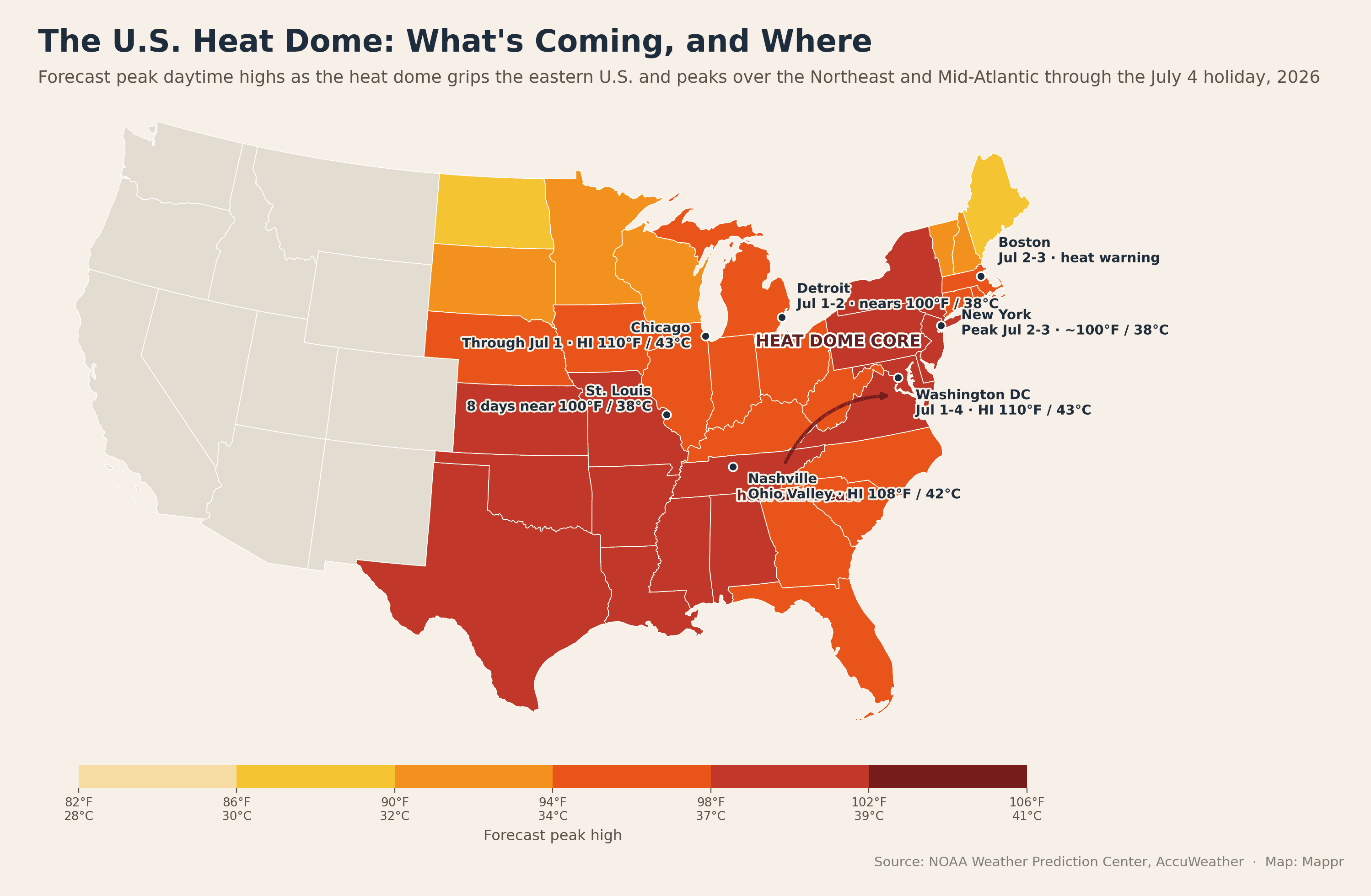
What’s coming, and when
The heat is over. NOAA’s active list carries no Extreme Heat Warnings, no Extreme Heat Watches and no Heat Advisories anywhere in the country this morning, against 14 advisories on 17 September.
The last products expired on Sunday. The final lower-48 Heat Advisories ran out at 8 p.m. on 20 September across Indiana, Kentucky, Illinois, Missouri, Tennessee, Kansas, Arkansas, Oklahoma, Mississippi and Alabama, and Puerto Rico’s last one at 3 p.m. on 21 September.
The ridge is breaking down as forecast. WPC’s 3:32 a.m. discussion on 24 September, valid 27 September to 1 October, still has highs in the 90s°F (32 to 37°C) over the southern Plains and Lower Mississippi Valley into early next week.
Then it moderates. The same discussion has cooler than average temperatures in the West spreading east and the Plains moderating by midweek, and it carries no heat headline at all, leading instead on a coastal storm in the Northeast and widespread rain in the Four Corners and Plains.
The fire season is stepping down with it. NIFC’s 23 September report cuts the national preparedness level to 2, with 30 uncontained large fires against 61 on 16 September, 87 active incidents and 8,523 personnel, 1,178 fewer in a day.
California has the one growing fire. The Dome fire north of Wawona Dome in Yosemite is at 3,989 acres and 15% containment on CAL FIRE’s 7:08 p.m. update, with 840 personnel assigned and containment estimated for 30 September.
The Big Sur pair is nearly done. Plaskett is at 29,993 acres and 97% containment and Timber at 25,437 acres and 59%, against 89% and 44% a week ago.
Texas and Oklahoma got rain. NIFC reports precipitation over the Hydra and Gracemont fire areas, Hydra at 933 acres and 78% containment and Gracemont at 2,690 acres and 99%, and the Southern Area is down to four uncontained large fires from 15.
The Northwest keeps closing out. Little Giant is at 172,850 acres and 81% containment and Sinlahekin at 166,007 acres and 92%, with 13 uncontained large fires left in the area.
Fire weather is narrow today. SPC has an Elevated highlight for the northwestern Great Basin, and the only Red Flag Warning in the country runs from 2 p.m. to 8 p.m. in Modoc County, California.
This is the last scheduled update. The heat dome that began building on 25 June has broken down, and NOAA has not issued an Extreme Heat Warning anywhere in the country since before 18 September.
Earlier updates follow.
17 September: the warnings are gone. NOAA’s active list carries no Extreme Heat Warnings and no Extreme Heat Watches anywhere in the country this morning, against 15 warnings on 10 September.
The advisory map rebuilt instead. Heat Advisories run from six to 14, all of them in the lower 48 and across ten states, and none of them west of Kansas.
The mid-South holds the highest numbers. NWS Little Rock and NWS Huntsville are both at a heat index of 109°F (43°C), NWS Tulsa at 108°F and NWS Nashville at 108°F.
The long ones run into the weekend. NWS Paducah is advised to 7 p.m. Sunday across the whole Quad State region, and Memphis, Nashville, Huntsville, Springfield and St. Louis to Saturday evening.
Paducah calls it near record to record. Its 12:59 a.m. discussion has highs in the middle 90s to around 100°F (38°C) and lows from around 70 to the middle 70s, 14 to near 20 degrees above normal, through Sunday.
Nashville has the ridge directly overhead. NWS Nashville puts a 500 mb ridge above 6,000 m over the Tennessee Valley, with HeatRisk at level 3 and 4 of 4 and heat index values peaking at 105 to 108°F (41 to 42°C).
Memphis is running on a 600 dam upper ridge, with near record to record highs in the upper 90s to low 100s°F each day and less than half an inch of rain expected through next Wednesday.
Wednesday tied and broke records. Nashville reached 99°F (37°C), tying its 2019 mark in a record that begins in 1871, and Memphis hit 98°F (37°C) with a low of 76°F, 13 and 14 degrees above normal.
Arkansas and Missouri broke theirs outright. Stuttgart reached 101°F (38°C) and Batesville 100°F (38°C), both past 1997 and 2019 marks, while Springfield, Missouri hit 98°F (37°C) past a 1980 record and Joplin tied 1954 at the same figure.
The heat is showing in the air as well. The Shelby County Health Department has a Code Orange ozone forecast for the Memphis area today, and TCEQ an Ozone Action Day for Dallas-Fort Worth.
The Southwest has flipped to flooding. NWS Phoenix has a Flood Watch through early tonight over much of southern Arizona, below-normal temperatures and widespread storms, with a Flash Flood Warning out of NWS Tucson.
The fire season moved south with the ridge. NIFC’s 16 September report makes the Southern Area the highest-priority geographic area, with nine new large incidents and 15 uncontained large fires, extreme fire behavior, structures threatened and evacuations in effect.
Texas took the brunt. The state has seven large fires for 112,852 acres, five of them new, led by Dry River near Sonora at 3,500 acres and no containment and Hydra near Meridian at 1,000 acres and 10%.
Oklahoma added two. Atoka Lake is at 727 acres and 50% containment and Calvary Creek near Rocky at 815 acres and 5%, with Gracemont still at 3,000 acres and no containment.
Nationally NIFC counts 61 uncontained large fires and more than 11,500 personnel, with 56,042 fires for 8,514,803 acres this year against a ten-year average of 5,786,645 acres.
The western fires keep easing. Plaskett is at 29,993 acres and 89% containment and Timber at 25,426 acres and 44%, with Little Giant at 172,705 acres and 81% and Sinlahekin at 166,000 acres and 81%.
Fire weather is elevated in two places today. SPC has Elevated highlights for southwest Oklahoma and the Red River Valley at 15 to 25% humidity, and for the Great Basin, where NWS Elko holds a Red Flag Warning at gusts of 30 to 35 mph and humidity of 10 to 15%.
Ahead, WPC’s extended discussion issued 16 September, valid 19 to 23 September, has the persistent and anomalous ridge over the South breaking down this weekend, with temperatures moderating by early next week.
Hazardous heat may hang on in parts of the south-central U.S., but WPC says it should not be nearly as widespread as this week, and CPC’s week 2 outlook for 24 to 30 September posts no heat hazards at all.
The heat has pulled back to the Southwest. NOAA’s active list carries 15 Extreme Heat Warnings this morning against 16 yesterday, all 15 in the lower 48 and across only three states: Arizona, California and Nevada.
The advisory map has collapsed. Heat Advisories fall from 26 to six across four states, four of them in California and two in the mid-South: NWS Little Rock at a heat index of 109°F (43°C) and NWS Memphis at 107°F (42°C).
Nothing is left east of Arizona. NWS Tulsa’s warning has expired, and no Extreme Heat Warning now touches the Plains, the Mississippi Valley or the East.
California still holds 12 of the 15. NWS Los Angeles/Oxnard runs the LA basin and the central coast at 88 to 108°F (31 to 42°C) to 8 p.m. Thursday, and NWS San Diego the coast, the inland valleys and the Inland Empire to the same hour.
The Oxnard office says this is the top. Its late-night discussion has temperatures easing a few degrees today but the relief largely unnoticeable with high humidity and warm nights, calls extensions to the heat hazards unlikely, and puts big drops on Friday and Saturday.
NWS San Diego agrees. A slow cooling trend begins today, major HeatRisk holds through Thursday on the coastal basin and through Friday in the low deserts, and highs run 5 to 10 degrees below normal from Sunday into early next week.
Wednesday was the record day on the coast. Five of the Oxnard office’s 14 climate stations broke calendar-day records and two tied: Long Beach 107°F (42°C) past 103°F from 2015, and downtown Los Angeles 105°F (41°C), tying its 2024 mark.
The central coast went with it. Paso Robles tied 1993 at 106°F (41°C) and Santa Maria broke a 1984 mark at 103°F (39°C), with Camarillo 99°F, Oxnard 98°F and Santa Barbara 96°F.
San Diego County produced the widest margins. Escondido reached 112°F (44°C) against 104°F from 2024 in a record that begins in 1893, with Santa Ana 108°F (42°C) in a record from 1906, Anaheim 107°F and Vista 105°F (41°C).
The Bay Area broke four. San Rafael hit 104°F (40°C) against 100°F from 2015, Oakland 97°F (36°C), SFO 94°F (34°C) past a 1951 mark and Half Moon Bay 83°F (28°C).
The desert peaks today. NWS Las Vegas warns Death Valley and the Colorado River Valley at 112 to 116°F (44 to 47°C) and the Las Vegas, Moapa and Pahrump valleys at 105 to 110°F (41 to 43°C), from 10 a.m. to 8 p.m.
NWS Phoenix holds the metro at 105 to 109°F (41 to 43°C) to 8 p.m. Thursday, with the Imperial Valley at 108 to 115°F (42 to 46°C) and Yuma at 107 to 110°F running into Friday evening.
The grid was projected to hold. CAISO forecast a peak of 47,379 MW on Wednesday and 45,183 MW today against 67,586 MW of available capacity, short of the state record of 52,061 MW set in September 2022.
The fire season steps down. NIFC’s 9 September report cuts the national preparedness level from 4 to 3, citing improving fire weather, better resource availability and light ordering, and drops uncontained large fires to 59.
The year-to-date count is 53,802 fires for 8,404,094 acres, 125% of the ten-year average for fires and 155% for acres, with Plaskett steady at 29,862 acres and 61% containment and Timber at 25,380 acres and 27%.
Ahead, WPC’s extended discussion, valid 12 to 16 September, keeps the ridge over the southern tier, with the greatest coverage of moderate to extreme HeatRisk on the southern Plains, Texas and the lower Mississippi Valley.
The West gets the break instead. A closed low reaches the Northwest by Saturday and the northern Plains by Monday behind a strong cold front, with heavy rain into the Upper Mississippi Valley and Great Lakes and wintry weather possible in the northern Rockies.
California is the front line now. NOAA’s active list carries 16 Extreme Heat Warnings this morning against 12 yesterday, all 16 in the lower 48 and across five states: Arizona, California, Nevada, Oklahoma and Arkansas.
Twelve of the 16 take in part of California. NWS Los Angeles/Oxnard made the upgrade it put at 20 to 30% yesterday, warning the LA basin, the San Fernando and Santa Clarita valleys and the county beaches at 88 to 108°F (31 to 42°C) to 8 p.m. Thursday.
NWS San Diego went with it. Its Extreme Heat Warning runs to 8 p.m. tonight for the coast, the inland valleys and the Inland Empire, at up to 107°F (42°C) in the San Bernardino and Riverside valleys and 106°F (41°C) in the San Diego County valleys.
The office is blunt about why this one is unusual. The marine layer is weak or absent, humidity is high, and highs and lows are running 5 to 15 degrees, locally 20, above normal, giving major to extreme HeatRisk through the coastal basin.
The Midwest round is over. Kansas and Missouri have dropped out of warnings entirely, and Heat Advisories fell from 30 to 26, all of them in the lower 48 across 12 states.
One warning is left outside the West. NWS Tulsa holds eastern Oklahoma and western Arkansas to 7 p.m. tonight at heat index values up to 112°F (44°C), the highest figure in any active warning.
Phoenix peaks today. NWS Phoenix has 500 mb heights building to 596 to 597 dam, near the NAEFS climatological maximum for the date, with metro highs of 105 to 109°F (41 to 43°C) to 8 p.m. Thursday and the Imperial Valley at 106 to 114°F (41 to 46°C) to Friday.
Tuesday broke records across the middle of the country. Salina tied its 1922 mark at 106°F (41°C), Concordia reached 106°F, Russell 105°F, Fort Smith 105°F and Wichita 104°F (40°C).
The heat set marks further out too. Oklahoma City hit 103°F (39°C) past a 1922 record, Memphis tied 1925 at 101°F (38°C), and McAllen broke its own record for a second straight day at 106°F (41°C).
California produced the coastal one. Newport Beach reached 97°F (36°C), past 95°F from 2022 in a record that begins in 1921, while Dallas-Fort Worth set a record warm low of 82°F (28°C).
Big Sur turned a corner. CAL FIRE has Plaskett at 29,884 acres and 61% containment, up 14 points overnight, with the neighbouring Timber fire steady at 25,380 acres and 27%.
NIFC’s 8 September report holds Preparedness Level 4 and cuts uncontained large fires to 64, with 53,665 fires for 8,397,760 acres nationally this year, 125% of the ten-year average for fires and 157% for acres.
Ahead, WPC’s extended discussion issued this morning, valid 12 to 16 September, keeps the long duration heat wave over the southern Plains and at times the mid-Mississippi Valley, with widespread major to extreme HeatRisk and more records in the forecast.
The West gets the break instead. A closed low reaches the Northwest by Saturday and the northern Plains by Monday, pushing a strong cold front through the northern tier, with wintry weather possible in the northern Rockies over the weekend.
The heat spread west on 8 September. NOAA’s active list carried 12 Extreme Heat Warnings that morning against nine the day before, all 12 in the lower 48 and across seven states: Arizona, California, Nevada, Kansas, Missouri, Oklahoma and Arkansas.
The advisory map more than doubled. NOAA lists 30 Heat Advisories, 29 of them in the lower 48 across 11 states, against 13 yesterday, reaching from the Bay Area to the Rio Grande Valley.
Two offices joined overnight. NWS Las Vegas warns Death Valley and the Colorado River Valley at 112 to 116°F (44 to 47°C) and the Las Vegas, Moapa and Pahrump valleys at 105 to 110°F (41 to 43°C), to 8 p.m. Thursday.
NWS San Diego warns the Coachella Valley, the San Diego County deserts and the San Gorgonio Pass near Banning at up to 110°F (43°C), from Wednesday to 8 p.m. Friday 11 September.
California is the new front. Heat Advisories now cover the Bay Area and Central Coast, the Sacramento Valley at 97 to 102°F (36 to 39°C), the San Joaquin Valley to 102°F and the Los Angeles basin at 85 to 105°F (29 to 41°C).
NWS Los Angeles/Oxnard calls humidity levels extreme for the basin Tuesday through Thursday, puts the highest heat illness risk on Wednesday, and gives a 20 to 30% chance of upgrading to an Extreme Heat Warning.
Phoenix peaks Thursday, not today. NWS Phoenix has the ridge at 594 to 597 dam, near the climatological maximum for the date, with lower desert highs of 106 to 110°F (41 to 43°C) and heat indices of 108 to 117°F (42 to 47°C).
Monday set records from the Pacific to the Gulf. San Diego reached 95°F (35°C), breaking 92°F from 1949 in a record that starts in 1875, with Vista at 102°F (39°C) and Oceanside Harbor at 93°F (34°C).
The Plains went with it. Salina hit 105°F (41°C), Fort Smith, Arkansas 105°F, Wichita 104°F (40°C) and El Dorado, Arkansas 103°F (39°C), past marks from 2013, 1947, 1947 and 1947.
South Texas broke three more. McAllen reached 105°F (41°C), Harlingen 102°F (39°C) and Brownsville 101°F (38°C), with Tuscaloosa, Meridian and Greenwood also at 101°F.
The Midwest round ends today. NWS Topeka runs to 7 p.m. at heat index values of 103 to 109°F (39 to 43°C), and NWS Kansas City and NWS Springfield to 8 p.m.
The sharpest numbers are further south. NWS Tulsa warns eastern Oklahoma and western Arkansas at up to 112°F (44°C), and NWS Brownsville has the day’s single highest figure, an advisory at 116°F (47°C).
The fire picture keeps easing. NIFC’s 7 September report holds Preparedness Level 4, cuts uncontained large fires to 66 from 75, and drops assigned personnel by 647 to 15,855.
The year-to-date count is 53,233 fires for 8,303,398 acres, 124% of the ten-year average for fires and 156% for acres, with no new large incidents reported.
Big Sur gained ten points. CAL FIRE has Plaskett at 29,862 acres and 47% containment, up from 37% yesterday with no growth at all, and Timber at 25,380 acres and 27%.
Ahead, WPC’s extended discussion issued this morning, valid 11 to 15 September, keeps the long duration heat wave over the Mid and Lower Mississippi Valley and southern Plains with widespread major to extreme HeatRisk and record highs and lows in the forecast.
The Southwest came back on 7 September. NOAA’s active list carried nine Extreme Heat Warnings that morning against six the day before, eight of them in the lower 48 and across four states: Arizona, California, Kansas and Missouri.
NWS Phoenix issued five of them at 12:33 a.m. MST, the first in the Southwest since the last ones expired on 29 August. The Phoenix metro is warned from 10 a.m. Tuesday to 8 p.m. Thursday 10 September at 105 to 109°F (41 to 43°C).
The Colorado River deserts run longer. Imperial County in California is warned to 8 p.m. Friday 11 September at 106 to 112°F (41 to 44°C), with Yuma at 107 to 109°F (42 to 43°C) and the Parker and Palo Verde valleys at 102 to 111°F (39 to 44°C).
The office says why. Its 10:25 p.m. discussion has 500 mb heights rising from 590 to 593 dam on Monday to 594 to 597 dam by early Wednesday, which it calls near record strength for this time of year.
The Midwest round is ending instead. NWS Topeka holds central and northeast Kansas to 7 p.m. Tuesday at heat index values of 100 to 107°F (38 to 42°C), with a cold front Tuesday evening into Wednesday.
NWS Kansas City keeps the metro to 8 p.m. Tuesday above 105°F (41°C) and NWS Springfield runs to 8 p.m. tonight at 105 to 110°F (41 to 43°C). St. Louis has no heat product at all.
Sunday ended the record lull. Springfield, Missouri reached 101°F (38°C) against a 1960 mark, Joplin 104°F (40°C) against 1954 and Batesville, Arkansas 105°F (41°C) against a 1939 record.
Arkansas took most of them. Hot Springs and Stuttgart both reached 104°F (40°C) and Fayetteville 103°F (39°C), while North Little Rock tied its 1990 record at 100°F (38°C).
The advisory map halved again. NOAA lists 13 Heat Advisories, 12 in the lower 48 across eight states, against 20 yesterday, running along the Gulf Coast, the southern Plains and central Kansas.
Southern California had the opposite weekend. Sunday set daily rainfall records at downtown Los Angeles (0.70 inches), LAX (0.59) and Burbank (1.30) on moisture from Hurricane Marie, and Barstow-Daggett set a record cold high of 77°F (25°C).
Big Sur keeps improving. CAL FIRE has Plaskett at 29,862 acres and 37% containment, up six points overnight, with Timber steady at 25,357 acres and 27%.
The national fire picture eased. NIFC’s 6 September report holds Preparedness Level 4, cuts uncontained large fires to 75 from 78, and drops assigned personnel by 1,310 to 16,502.
The year-to-date count is 53,165 fires for 8,302,657 acres, 125% of the ten-year average for fires and 158% for acres, a shade below the acreage the 5 September report carried after a revision.
Ahead, WPC’s extended discussion issued this morning, valid 10 to 14 September, keeps the long duration heat wave over the Mid and Lower Mississippi Valley to southern Texas with widespread major to extreme HeatRisk.
The wave came apart on 6 September. NOAA’s active list carried six Extreme Heat Warnings that morning against 11 the day before, and only five of them in the lower 48, across three states: Kansas, Missouri and Arkansas.
Four states dropped out overnight. Illinois, Indiana, Iowa and Kentucky are all clear of warnings, and NWS St. Louis has let the metro fall to a Heat Advisory until 7 p.m. today after two days at warning level.
Kansas still has the longest run. NWS Topeka reissued at 1:50 a.m. for central and northeast Kansas at heat index values of 100 to 108°F (38 to 42°C), held to 7 p.m. Tuesday 8 September.
Kansas City is warned that far too. NWS Kansas City keeps the metro and eastern Kansas to 8 p.m. Tuesday at up to 105°F (41°C), with its northern band expiring at 8 p.m. tonight at up to 104°F (40°C).
The sharpest number today is in Arkansas. NWS Tulsa warns Sebastian, Crawford and Franklin counties from noon to 7 p.m. at heat index values up to 112°F (44°C), the highest figure in any active product in the country.
Springfield is already writing the ending. Its warning runs to 8 p.m. at up to 107°F (42°C), with a note that an approaching front brings relief to central Missouri and the eastern Ozarks today and farther west on Monday.
The advisory map roughly halved. NOAA lists 20 Heat Advisories, 19 in the lower 48 across 11 states, against 34 yesterday, and the survivors now run along the Gulf Coast and the mid-South rather than the corn belt.
The break is real this time. NWS St. Louis has the backdoor cold front through before dawn, lower dewpoints areawide tonight into Labor Day and highs in the upper 80s to low 90s°F (31 to 34°C).
The office puts a number on how different that feels: more than 20 degrees cooler than Saturday’s heat index values, with the return of heat on Tuesday and Wednesday now expected to be brief.
Kansas City is the exception. Its front stalls north and west of the Missouri River, so the metro stays warned to Tuesday, with a 30 to 50% chance of storms this afternoon and a Marginal Risk of damaging wind and hail.
Saturday was hot without being historic. St. Louis reached 101°F (38°C) against a 103°F mark from 1925, Salina and Tulsa hit 103°F (39°C) and Memphis and Birmingham 102°F (39°C).
None of the major Midwest or mid-South climate sites set a daily record high, the first day of this stretch without one, though St. Louis still held at 81°F (27°C) overnight.
Behind the front the contrast was stark. Chicago O’Hare topped out at 81°F (27°C) a day after its record warm low of 76°F, with Columbus at 83°F (28°C) and Rockford at 84°F (29°C).
Big Sur keeps improving. CAL FIRE put the Plaskett fire at 29,831 acres and 31% containment on Saturday evening, up from 23%, with the neighboring Timber fire at 25,357 acres and 27%.
The national fire picture is mixed. NIFC held the National Preparedness Level at 4 in its 5 September report but counted 78 uncontained large fires against 77, with six new large incidents and 17,812 personnel assigned.
The year-to-date total keeps climbing. NIFC counts 53,030 fires for 8,307,707 acres, 125% of the ten-year average by fire count and 159% by acreage.
One Red Flag Warning is back on the map. NWS Missoula has the eastern Beaverhead National Forest in Montana under one from noon to 9 p.m. MDT, on south winds gusting to 40 mph and humidity of 15 to 25%.
The warning count edged up to 11 on 5 September, against 10 the day before, still across the same six states: Iowa, Illinois, Indiana, Kansas, Kentucky and Missouri.
Missouri is where it grew. NWS Springfield upgraded its entire forecast area from advisory to an Extreme Heat Warning to 8 p.m. Sunday 6 September, at heat index values up to 110°F (43°C).
The office is blunt about why. It says the NWS HeatRisk tool is maxed out in the Extreme category through Sunday, and that hot, dry conditions are worsening drought and raising fire danger.
St. Louis has the sharpest day. NWS St. Louis reissued the metro warning at 2:29 a.m. at heat index values up to 110°F (43°C) to 8 p.m., with a second warning up to 108°F (42°C) across central and southeast Missouri and southwest Illinois.
Kansas keeps the longest run. NWS Topeka nudged its warning up to 100 to 108°F (38 to 42°C) and holds it to 7 p.m. Tuesday 8 September, with NWS Kansas City warned to 8 p.m. Tuesday.
The advisory map shrank behind them. NOAA lists 34 Heat Advisories, 33 in the lower 48 across 17 states, against 43 across 20 states yesterday, with no Extreme Heat Watch and no Red Flag Warning anywhere in the country.
Friday moved the daytime records east. Danville, Virginia reached 102°F (39°C) and Lynchburg 100°F (38°C), both past marks set in 1925, while Cincinnati broke 2007 at 97°F (36°C) and Lexington tied 1954 at 98°F (37°C).
The nights broke more of them. St. Louis stayed at 81°F (27°C), tying a 1925 record, Louisville at 78°F (26°C) past 1925, and Chicago O’Hare at 76°F (24°C) past 1971.
Relief is close now. NWS St. Louis has a backdoor cold front crossing tonight, a break on Sunday and Labor Day Monday, and a second round of heat Tuesday into Wednesday that it now expects to be much shorter.
Big Sur improved. CAL FIRE put the Plaskett fire at 29,768 acres and 23% containment on Friday evening, up from 19%, with 2,058 personnel assigned.
The national picture eased a notch. NIFC lowered the National Preparedness Level from 5 to 4 in its 4 September report, with 77 uncontained large fires and 18,401 personnel assigned.
The warning count climbed again on 4 September. NOAA’s active list carried 10 Extreme Heat Warnings against seven the day before, across six states: Iowa, Illinois, Indiana, Kansas, Kentucky and Missouri.
Kansas is the new front. NWS Topeka warns central, north central and northeast Kansas to 7 p.m. Tuesday 8 September at afternoon heat index values of 100 to 107°F (38 to 42°C).
The office calls today the seventh consecutive day of heat indices reaching 100 degrees or more, and says the prolonged nature of the heat wave is its most dangerous aspect.
Kansas City went further. NWS Kansas City upgraded its whole forecast area to a warning through Saturday evening and pushed the ground south of a St. Joseph to Boonville line out to 8 p.m. Tuesday, and says it may yet need to extend into Wednesday.
The advisory map shrank as the warnings grew. NOAA lists 45 Heat Advisories, 43 of them in the lower 48 across 20 states, against 53 across 25 states yesterday, with the Cook County warning expired and Chicago down to an advisory south of the city.
Thursday broke records again. Laredo reached 108°F (42°C), past 106°F from 1992 and a second straight daily record, and McAllen tied its 2011 mark at 106°F (41°C).
The nights were the bigger story. Lincoln, Nebraska bottomed out at 79°F (26°C), four degrees past a 1937 record in a series that starts in 1887, and Omaha at 78°F (26°C) beat a 1925 mark.
Record warm lows ran across six states. Russell, Kansas (79°F / 26°C), Concordia, Kansas (80°F / 27°C) and Hastings, Nebraska (73°F / 23°C) all set or tied marks for 3 September.
So did the east side of it. Dubuque (74°F / 23°C), Springfield, Illinois (76°F / 24°C), South Bend (75°F / 24°C), Columbus (75°F / 24°C) and Charlotte (76°F / 24°C), where records go back to 1878.
St. Louis is already looking past this round. It expects a backdoor front to ease things from Sunday into Labor Day, then near-record heat back by Wednesday.
That next ridge is the one to watch. The office says the 500 hPa ridge is likely to be record breaking in strength for early September, with 850 hPa temperatures above the 99th percentile, and may deliver the hottest temperatures of the whole stretch.
Big Sur finally turned. CAL FIRE put Plaskett at 29,702 acres and 19% containment late Thursday, its first real progress after a week at 1%, with Timber at 25,346 acres and 23%.
The national fire numbers keep easing. NIFC’s 3 September report counts 52,767 fires for 8,272,749 acres this year, 161% of the ten-year average for acres, and cuts uncontained large fires from 84 to 78.
Fire weather moved north. Six Red Flag Warnings run this afternoon over Wyoming, Montana, North Dakota and South Dakota, while rain over the Little Giant fire in Washington helped lift it to 65% containment at 170,784 acres.
On 3 September the warning count more than tripled. NOAA’s active list carried seven Extreme Heat Warnings that morning against two the day before, all of them in the Midwest and mid-Mississippi Valley across Iowa, Illinois, Indiana, Kentucky and Missouri.
St. Louis had the highest numbers. NWS St. Louis upgraded the metro, southwest Illinois and east central Missouri to 8 p.m. Saturday 5 September at heat index values up to 110°F (43°C).
Chicago went under a warning for a single day. NWS Chicago covered all three Cook County zones to 7 p.m. at 100 to 105°F (38 to 41°C), a third straight day above a 100-degree heat index.
That one had an end in sight. The office expected a cold front off Lake Michigan that afternoon, possibly with thunderstorms, to bring rapidly improving conditions.
The advisory map grew again. NOAA lists 54 Heat Advisories, 53 of them in the lower 48 across 25 states, against 51 across 22 states yesterday.
Wednesday broke records from the border to the Carolinas. Laredo reached 107°F (42°C) and Raleigh 100°F (38°C), both past marks set in 1912, with Brownsville at 102°F (39°C) and Asheville at 92°F (33°C).
The nights broke records too. Washington Dulles (73°F / 23°C), Charlotte (75°F / 24°C), Des Moines (75°F / 24°C) and Salina, Kansas (78°F / 26°C) all set record warm lows for 2 September.
The national fire numbers eased slightly. NIFC’s 2 September report counts 52,626 fires for 8,265,751 acres this year, 163% of the ten-year average for acres, and cuts uncontained large fires from 87 to 84.
Plaskett is still the exception. CAL FIRE put the Big Sur fire at 29,123 acres at 1% containment late Wednesday, and Highway 1 reopened its northern segment at 6 a.m. today while the southern closure stays shut.
Red Flag Warnings are back on the map. Seven of them run this afternoon over Wyoming, Montana and western South Dakota, with NWS Cheyenne citing southwest gusts to 35 mph and humidity of 10 to 15%.
On 2 September the Extreme Heat Warnings came back. NOAA’s active list carried two Extreme Heat Warnings that morning, the first anywhere in the country since the last Arizona and California products expired on 29 August.
Both sit in the mid-Mississippi Valley. NWS Paducah covers all of southern Illinois, southwest Indiana, western Kentucky and southeast Missouri to 8 p.m. Saturday 5 September, and NWS Quad Cities covers eastern Iowa, western Illinois and northeast Missouri to 7 p.m. Friday 4 September.
Paducah has the harder numbers. It forecasts daily heat index values of 103 to 109°F (39 to 43°C), afternoon highs of 95 to 101°F (35 to 38°C) and record warm overnight lows in the mid 70s°F (mid 20s°C), 10 to 15 degrees above normal.
Quad Cities upgraded on duration, not peak. Its heat index values run 100 to 105°F (38 to 41°C), but four consecutive days above 100 was enough to lift the advisory to a warning.
The advisory map kept growing under them. NOAA lists 52 Heat Advisories, 51 of them in the lower 48 across 22 states, against 28 across 17 states yesterday.
The eastern edge moved south. Philadelphia and southern New Jersey dropped out overnight, and Virginia, West Virginia, south central Pennsylvania, the Carolinas and north Georgia came in at heat index values of 102 to 109°F (39 to 43°C).
The highest values in the country are on the Texas coast. NWS Brownsville has 115°F (46°C) and NWS Corpus Christi 113°F (45°C) this afternoon.
Monday tied a record. The NWS Chicago climate site at Romeoville reached 93°F (34°C), matching the 1 September record set in 2000, with an overnight low of 74°F (23°C), 14 degrees above normal.
Indianapolis and Little Rock ran hot without records. Indianapolis hit 96°F (36°C), 13 degrees above normal against a 1953 record of 100°F, and North Little Rock reached 98°F (37°C).
St. Louis added a day. The office extended its Heat Advisory to 8 p.m. Saturday, with 850 mb temperatures of 20 to 23°C into Thursday and heat index values of 98 to 106°F (37 to 41°C).
It has an air quality problem with it. NWS St. Louis carries an Air Quality Alert for the metro and southwest Illinois until 8 p.m. today, and puts the upper high over Kentucky and Tennessee this morning.
The fire year passed 8.26 million acres. NIFC’s 1 September report counts 52,466 fires for 8,262,025 acres, 164% of the ten-year average, and cuts uncontained large fires from 93 to 87.
Big Sur is still the worst of it. InciWeb has Plaskett at 27,580 acres at 1% containment with 955 firefighters, after overnight humidity near 90% let crews fire off dozer line from Gorda north to Prewitt Ridge.
Timber is at 25,223 acres at 22%, and its assigned personnel have fallen from 2,016 to 1,321. Roughly 40 miles of Highway 1 stay closed, and both fires share a public meeting in Carmel at 6 p.m. tonight.
Washington’s Little Giant grew again, to 170,784 acres at 49% containment, with 240 Joint Base Lewis-McChord soldiers assigned. Idaho’s Wildhorse fire reached 100% containment at 107,562 acres.
Oklahoma’s Railroad South fire, where a federal wildlife officer died last week, is at 515 acres and 20% contained, with crews estimating full containment on 3 September.
There is no clean end date. WPC’s Tuesday discussion, valid 4 to 8 September, keeps dangerous heat over the central U.S. through the weekend into early next week, with a front easing the Southeast late this week.
Then it holds. CPC’s hazards outlook issued 1 September carries a moderate risk of extreme heat in the southern Plains and the lower and middle Mississippi Valley on 9 September.
The heat nearly doubled its footprint overnight. NOAA still lists no Extreme Heat Warnings and no Extreme Heat Watches anywhere in the lower 48, but Heat Advisories have gone from 16 to 28, now across 17 states.
The ridge has slid east. NWS Norman puts the center of the 596 dam upper high near the Ohio River Valley today, which is why the alerts have finally jumped the Mississippi.
The Ohio Valley and Mid-Atlantic are in it for the first time this round. NWS Cleveland, Wilmington, Louisville, Charleston and Mount Holly all issued advisories overnight, taking the heat to Philadelphia, northern Delaware and southern New Jersey until 8 p.m. today.
Chicago and Mississippi have the sharpest numbers. NWS Chicago warns of heat index values of 100 to 110°F (38 to 43°C) across northeast Illinois and northwest Indiana today, and NWS Jackson has values up to 110°F (43°C).
The mid-Mississippi Valley leg runs longest. NWS St. Louis, Springfield, Paducah and Kansas City are all warned to 8 p.m. Friday 4 September at heat index values of 100 to 108°F (38 to 42°C).
St. Louis stayed just under its record. Lambert reached 99°F (37°C) on Monday, 13 degrees above normal, against a date record of 103°F set in 2011 and matched in 2013.
St. Louis expects no quick end. The office has 850 mb temperatures near 22°C into Wednesday, heat index values of 98 to 105°F (37 to 41°C) each afternoon, and the ridge retrograding west over the Plains this weekend.
The Southwest is cold by comparison. Phoenix topped out at 91°F (33°C) on Monday, 13 degrees below normal, with 0.16 inches of rain, and Las Vegas hit exactly normal at 100°F (38°C).
Arizona has dropped its Flood Watches as well. All of them expired overnight, and the only Flood Watches left in the country are on the upper Texas coast and in southwest Louisiana.
That is Edouard. The National Hurricane Center has Tropical Storm Edouard 85 miles southeast of Cameron, Louisiana at 40 mph, with a Hurricane Watch up and landfall on the upper Texas coast expected later today.
The fire side of this event has its first death. NIFC’s 31 August report records a federal wildlife officer fatally injured while helping residents evacuate the Railroad South fire near Indiahoma, Oklahoma.
Local reporting names him. Oklahoma outlets identify the officer as David Taylor, 38, of Scio, Oregon, based at the Wichita Mountains Wildlife Refuge, and put the fire at about 515 acres with all evacuation orders lifted.
Plaskett has run away on the Big Sur coast. InciWeb had it at 26,734 acres at 1% containment with 955 personnel late Monday, up from 8,241 acres on Saturday, and it is now the bigger of the two fires there.
Timber is at 25,190 acres at 22% containment with 2,016 personnel, and roughly 40 miles of Highway 1 stay closed for the pair.
Washington and Idaho improved. NIFC has Little Giant at 163,089 acres at 49% containment, up from 27%, Sinlahekin at 166,413 acres at 40% after a mapping correction, and Idaho’s Wildhorse at 107,562 acres at 95%.
The national totals keep climbing. NIFC counts 52,253 fires for 8,238,284 acres this year, 166% of the ten-year average for acres, with uncontained large fires down to 93 at Preparedness Level 5.
There is an end date this week. WPC’s extended discussion, valid 3 to 7 September, keeps dangerous heat from the central U.S. to the Southeast through Friday before a cold front brings relief over the weekend.
Then it restarts. CPC’s week 2 outlook, issued 31 August, carries a moderate risk of extreme heat for the central and southern Plains and the middle and lower Mississippi Valley on 8 to 9 September.
The heat is back, in a different place. NOAA’s active list still holds no Extreme Heat Warnings and no Extreme Heat Watches anywhere in the lower 48, but Heat Advisories have gone from three to 16 as the ridge rebuilds over the middle of the country.
This is a Midwest and mid-South event now. The advisories run from central Iowa, northeast Kansas and Missouri across Illinois, southwest Indiana and western Kentucky to Arkansas, west Tennessee and Mississippi at heat index values of 100 to 109°F (38 to 43°C).
It is a long one. NWS St. Louis, Springfield and Paducah are warned to 8 p.m. Friday 4 September and NWS Lincoln to Thursday evening, covering the whole Labor Day week.
St. Louis is the focus. The office calls it a prolonged regional heatwave from Monday through at least Friday with near-record warmth, and flags heightened potential for impacts in the metro and southwest Illinois.
The Southwest has cooled off fast. Phoenix topped out at 106°F (41°C) on Sunday, seven degrees down from Saturday, Las Vegas at 101°F (38°C), exactly normal, and Tucson at 99°F (37°C).
Water is the hazard there now. NWS Phoenix, Tucson and Flagstaff hold Flood Watches through Monday evening, and WPC has a Moderate Risk (level 3 of 4) of excessive rainfall over the Great Basin.
Oklahoma stays hot and dry. NWS Norman has the subtropical ridge holding with highs in the upper 90s to mid 100s°F through the week, a Rangeland Fire Danger Statement in force and no rain forecast before late week.
The fire year passed another marker. NIFC’s 30 August report counts 51,961 fires for 8,221,246 acres this year, 163% of the ten-year average, and pushed uncontained large fires back up to 98 from 92.
Big Sur is still the worst of the fires. Plaskett has its first line at 8,241 acres and 1% containment with 661 personnel, and Timber is at 24,839 acres at 21% with 2,192 personnel and $79 million spent.
Washington’s two big fires both moved. Sinlahekin near Tonasket grew 652 acres to 166,868 with containment revised down to 41%, and Little Giant holds at 162,961 acres at 27% with $112.6 million spent.
Idaho’s Wildhorse fire turned the corner. NIFC has it at 107,562 acres at 70% containment north of Kimama with no growth reported and behavior down to minimal.
Next week is an eastern story. WPC’s extended discussion issued early Monday, valid 3 to 7 September, keeps dangerous heat from the central and southern Plains to the Midwest, Mid-Atlantic and Southeast through Friday before a cold front eases the Ohio Valley.
The heat warnings are gone. NOAA’s active alert list holds no Extreme Heat Warnings and no Extreme Heat Watches anywhere in the lower 48 on Sunday morning, after the last Arizona and California products expired at 8 p.m. Saturday 29 August.
What is left is small, and it sits east of the deserts. Three Heat Advisories cover central, northern and northeast Oklahoma and the Palo Duro Canyon in Texas, at values of 105 to 107°F (41 to 42°C) through Sunday evening.
Saturday still ran hot in Phoenix. Sky Harbor reached 113°F (45°C) at 3:17 p.m. with an overnight low of 94°F (34°C), nine degrees above normal but short of the 116°F date record from 2023.
Las Vegas ended its record run at 105°F (41°C), well under the 110°F shared by 1944, 1948 and 2017, and Tucson eased to 104°F (40°C) with 0.14 inches of rain.
Arizona has flipped from heat to water. NWS Phoenix, Tucson and Flagstaff all carry Flood Watches for monsoon storms into Monday, with localized totals of 1 to 2 inches and a flash flood risk.
The forecast turns cool there. NWS Phoenix expects near to slightly below normal temperatures from Sunday into the first half of the week, and NWS Las Vegas has the Mojave bottoming out about five degrees below normal by midweek.
The heat has moved to the southern Plains. NWS Norman has the ridge centered over Oklahoma with highs of 100 to 107°F (38 to 42°C), and issued a Fire Danger Statement for western and central Oklahoma and western north Texas.
Next week is an eastern story. WPC’s discussion issued early Sunday, valid 2 to 6 September, keeps dangerous heat from the central and southern Plains to the Midwest, Mid-Atlantic and Southeast at widespread Major to Extreme HeatRisk.
Relief comes late and partial. A cold front may ease the Ohio Valley and Mid-Atlantic next weekend, but WPC expects the core to hold from the Plains to the Mississippi Valley into the second week of September.
Big Sur is the worst of the fires. The Plaskett fire is at 8,241 acres with no containment and 661 personnel, has backed down to Highway 1, and the hard State Route 1 closure runs from mile marker 10.2 north of Gorda to mile marker 50.1 at Old Coast Road.
Timber is the larger fire, at 24,839 acres at 21% containment southeast of Big Sur, with evacuation orders, warnings and a shelter-in-place still in force along the closure.
Idaho’s Wildhorse fire kept running. NIFC’s 29 August report puts it at 107,562 acres at 21% containment north of Kimama, up 17,562 acres, though rain fell over the fire area and behavior is down to smoldering.
Washington’s two big fires both grew. Little Giant is at 162,961 acres at 27% with $110.4 million spent, and Sinlahekin near Tonasket at 166,216 acres at 49%, still showing extreme fire behavior.
The year passed a marker. NIFC holds Preparedness Level 5 but cut uncontained large fires to 92, down from 97, and counts 51,774 fires for 8,107,724 acres this year, 165% of the ten-year average for acres.
Fire weather has almost emptied out. There is no Red Flag Warning anywhere in the country, and the only Fire Weather Watch runs Monday afternoon and evening over Siskiyou and Modoc counties in California and the Klamath Basin in Oregon.
Smoke is the new hazard. Air Quality Alerts cover Chelan, Douglas and Okanogan counties in Washington and Crook, Jefferson and Wasco counties in Oregon, where particulates may reach unhealthy levels downwind of the fires.
The Northwest gets rain midweek. WPC expects a Pacific storm and a weak to moderate atmospheric river to bring heavy rain to coastal Washington and Oregon and the Cascades on Wednesday and Thursday.
One number sums up the turn. NWS Pendleton had a Freeze Warning out overnight for Wallowa County, Oregon, with temperatures as low as 30°F (-1°C).
The Southwest is on its last warned day. NOAA’s active list is down to 12 Extreme Heat Warnings across two states, Arizona and California, and every one of them expires at 8 p.m. Saturday 29 August.
Nevada is out. The NWS Las Vegas warning for the Mojave Desert expired on Friday evening without renewal, and the office called Friday the last day of dangerous heat before a cooling trend.
Southern California stepped down with it. NWS Los Angeles/Oxnard let its Extreme Heat Warning end at 8 p.m. Friday and replaced it with a Heat Advisory to 8 p.m. Saturday, writing that this will be the last of it and the last straw of the ongoing heat event.
The rest of the map has emptied. Heat Advisories in the lower 48 are down to six, five in California and one for the Palo Duro Canyon in Texas, with no Extreme Heat Watches anywhere.
Every fire-weather headline has gone too. The five California Red Flag Warnings expired at 3 p.m. Friday, and there is now no Red Flag Warning or Fire Weather Watch anywhere in the country.
Friday still ran hot in Arizona. Phoenix Sky Harbor reached 112°F (44°C) with an overnight low of 94°F (34°C), Tucson hit 106°F (41°C) and Las Vegas eased to 107°F (42°C), ending its record run.
One record still fell. Escondido, California reached 105°F (41°C), past the 102°F set in 2015, in a book that opens in 1893.
Thursday night in Las Vegas was historic. The city set a record warm low of 92°F (33°C), past 87°F from 2011, and NWS Las Vegas says it is the latest date on record, back to 1937, that the city has held a low at or above 90°F.
Big Sur is the new emergency. CAL FIRE puts the Plaskett fire at 5,924 acres with no containment, against 140 acres on Thursday, and the CHP has closed 46 miles of Highway 1 from Gorda to the Little Sur River.
The Timber fire is still the bigger one, at 23,365 acres at 21% containment southeast of Big Sur, with evacuation orders, warnings and a shelter-in-place in force along the closure.
Idaho’s Wildhorse fire nearly doubled. NIFC’s 28 August report puts it at 90,000 acres at 15% containment north of Kimama, a jump of 40,000 acres in a day, with Carey eased from a Level 3 order to Level 2 and Richfield at Level 1.
The Northwest fires kept growing. Little Giant is at 156,448 acres at 25% with $101.6 million spent, and Sinlahekin near Tonasket at 163,001 acres at 49%.
The national count went the wrong way again. NIFC holds Preparedness Level 5 with 97 uncontained large fires, up from 94, and counts 51,629 fires for 7,994,316 acres this year, 163% of the ten-year average for acres.
Next week goes east. WPC’s discussion issued early Saturday, valid 1 to 5 September, spreads dangerous heat from the central and southern Plains to the Midwest, Mid-Atlantic and Southeast at widespread Major to Extreme HeatRisk.
The warned count ticked back up. NOAA’s active list holds 22 Extreme Heat Warnings in the lower 48, still across three states, Arizona, California and Nevada, after NWS Flagstaff added the Yavapai County valleys and Grand Canyon Country.
Behind them the advisory map has nearly gone. Heat Advisories in the lower 48 are down to six, every one of them in California, with Texas out entirely and no watches anywhere.
Arizona eased on Thursday. Phoenix Sky Harbor reached 111°F (44°C) after Wednesday’s 117°F, with an overnight low of 95°F (35°C), and Tucson topped out at 106°F (41°C). Neither office filed a record report.
Las Vegas did it again. The city broke its 27 August record at 111°F (44°C), past the 110°F set in 2017, a second record day running in a book that starts in 1937.
The records also spread inland. Grand Junction, Colorado tied its date record at 98°F (37°C) and Rock Springs, Wyoming tied at 90°F (32°C).
Southern California turned the other way. The remnants of Tropical Storm Iselle arrived, and NWS Los Angeles/Oxnard logged Thursday highs 5 to 12 degrees cooler in Los Angeles and Ventura counties and 15 to 25 degrees down farther north.
Records still fell in the gaps. NWS Oxnard hit a new 94°F (34°C) and Camarillo 93°F (34°C), while Campo in San Diego County tied 1981 at 105°F (41°C).
Iselle set rain records on the same day. Santa Barbara Airport broke a trace record from 1972 with 0.01 inches, and Los Angeles, Long Beach and Burbank airports all tied trace records of their own.
Fire weather moved to California with the moisture. All five Red Flag Warnings in the country run to 3 p.m. Friday in California, from the Santa Cruz and Santa Lucia mountains to the Santa Susana and eastern San Gabriel ranges, with dry lightning now the ignition risk.
Big Sur is where that risk is already live. NIFC puts the Timber fire, burning in Los Padres National Forest since 8 August, at 18,994 acres at 21% containment, and the new Plaskett fire at 140 acres with no containment.
The national picture got worse again. NIFC’s 27 August report counts 94 large fires with 21,854 personnel assigned and 51,434 fires for 7,971,399 acres this year, 164% of the ten-year average for acres.
The two big Northwest fires barely moved. Little Giant in Washington is at 149,863 acres at 23%, and Idaho’s Wildhorse is holding at 50,000 acres at 10% north of Kimama.
The break now has a mechanism. NWS Phoenix expects a Pacific trough to push the subtropical high into the Southern Plains by Sunday, easing Phoenix to 107 to 109°F (42 to 43°C) on Saturday with storm chances of 40 to 60% on Sunday.
The warned map keeps shrinking. NOAA’s active list is down to 20 Extreme Heat Warnings in the lower 48, still across three states, Arizona, California and Nevada, with 10 Heat Advisories behind them and no watches anywhere.
Phoenix tied its hottest 26 August. Sky Harbor reached 117°F (47°C) at 3:16 p.m. Wednesday, matching the 2011 record and running 12 degrees above normal, with a morning low of 91°F (33°C).
Two more fell with it. Las Vegas hit 110°F (43°C), past the 109°F mark shared by 1944 and 2001, and Tucson tied its 2011 record at 108°F (42°C).
Southern California set seven of its own. Woodland Hills reached 111°F (44°C) and Lancaster 107°F (42°C), while downtown Los Angeles tied its 1981 record at 98°F (37°C).
The Southwest bought another day. NWS Phoenix and NWS Tucson both pushed their Extreme Heat Warnings to 8 p.m. Saturday 29 August, with metro afternoons of 107 to 114°F (42 to 46°C) and 500 mb heights at 598 dam, the climatological maximum for late August.
Fire weather has followed the heat to the coast. NWS Los Angeles/Oxnard has a Red Flag Warning to 3 p.m. Friday for the interior mountains and valleys, warning of plume-dominated fires with rapid spread and extreme fire behavior.
In Idaho the Wildhorse fire more than doubled. NIFC puts it at 50,000 acres at 10% containment north of Kimama, and the Lincoln County Sheriff’s Office has told Richfield, 8 miles west of it, to be ready to leave.
The national count went the wrong way. NIFC’s 26 August report holds Preparedness Level 5 with 93 uncontained large fires, up from 86, and counts 51,295 fires for 7,920,585 acres this year, 165% of the ten-year average for acres.
Maricopa County has published its toll. The county’s 25 August heat surveillance report confirms 113 heat-associated deaths this year with 584 more under investigation, against 35 confirmed at the same point in 2025.
Relief has a date on it. WPC’s 27 August discussion, valid 30 August to 3 September, moderates the excessive heat threat over the Desert Southwest and expands hazardous heat across the south-central U.S. into the Midwest and South next week.
The southern Plains has dropped out. NOAA’s active list is down to 23 Extreme Heat Warnings in the lower 48, across just three states, Arizona, California and Nevada, after the Texas and Oklahoma warnings expired without renewal.
The advisory map shrank with it. Heat Advisories in the lower 48 fell from 35 to 17, most of them over Texas and Louisiana, and there are still no Extreme Heat Watches anywhere.
Phoenix set a record on Tuesday. Sky Harbor reached 115°F (46°C) at 3:13 p.m., past the 113°F (45°C) mark set in 2011 and 10 degrees above normal, with a morning low of 89°F (32°C).
Tucson tied one. The city hit 107°F (42°C), matching its 2020 record for the date, while Las Vegas reached 108°F (42°C) with a low of 85°F (29°C).
The coast set one too. Los Angeles International Airport reached 85°F (29°C) at 9:22 a.m. Tuesday, past the 1981 record of 84°F and 8 degrees above normal.
NWS Los Angeles/Oxnard calls the warnings locked in through 8 p.m. Friday, with several more calendar-day records expected to fall and little change likely before then.
Sundowner winds are the new wrinkle. The office added a Wind Advisory for southern Santa Barbara County overnight after the pressure gradient jumped a millibar in an hour, and the winds return each night through Thursday.
Phoenix holds to Saturday. Ensembles peak H5 heights at 595 to 598 dam through Thursday and 850 mb temperatures at 29 to 32C, above the 99th percentile, with lower desert highs near 115°F (46°C) challenging records.
Fire weather moved back north. Red Flag Warnings returned today for the Klamath Basin and south central Oregon and for the Palouse and Hells Canyon, at humidity of 9 to 15%, with Fire Weather Watches on Thursday for the Owyhees, the Okanogan Valley and the Waterville Plateau.
The Little Giant fire in Washington is now 147,626 acres at 23% containment with 1,857 personnel, and NIFC has 240 soldiers from Joint Base Lewis-McChord assigned to it alongside Australian and New Zealand crews.
There has been a death on the fire lines. NIFC reports that an incident support crewmember with the U.S. Wildland Fire Service suffered a fatal medical emergency on 23 August while assigned to the Frijoles incident in New Mexico.
Ahead, the Southwest gets a break and the Plains do not. WPC’s discussion issued today, valid 29 August to 2 September, flattens the ridge this weekend and shifts it east, easing the Desert Southwest while hazardous heat expands north into the southern Plains and Mid-South.
On Tuesday the watches had become warnings, with NOAA’s active list up to 25 Extreme Heat Warnings across five states, Arizona, California, Nevada, Oklahoma and Texas, and 35 Heat Advisories in the lower 48.
Southern California is in it now. NWS Los Angeles/Oxnard upgraded at 10 a.m. Tuesday through 8 p.m. Friday, with the Antelope and Santa Clarita valleys at up to 112°F (44°C) and the Los Angeles county beaches and downtown Los Angeles at up to 102°F (39°C).
The warned coast is the unusual part. The office expects highs of 100 to 110°F (38 to 43°C) within 5 to 10 miles of the beaches over a 72-hour stretch, with several calendar-day records likely to fall.
San Diego went with it. NWS San Diego holds seven warnings to 8 p.m. Friday, with the Coachella Valley and the San Diego County deserts at 110 to 115°F (43 to 46°C) and the Inland Empire up to 110°F (43°C) from Tuesday morning.
Nevada is back in. The NWS Las Vegas warning now runs to 8 p.m. Friday at 115 to 118°F (46 to 48°C) through Death Valley and the Colorado River Valley, and 108 to 112°F (42 to 44°C) in the Las Vegas Valley.
The Grand Canyon joins on Wednesday. NWS Flagstaff issued its first warnings of this stretch, for the canyon below 4,000 feet at 107 to 112°F (42 to 44°C) at Phantom Ranch and the Yavapai County valleys at 105 to 110°F (41 to 43°C).
Phoenix and Tucson hold to Saturday. NWS Phoenix has ensemble H5 heights reaching 595 to 597 dam by Wednesday, around the 98th to 99th percentile of climatology, with metro afternoons of 106 to 116°F (41 to 47°C) near daily records.
Monday itself was a step down. Phoenix Sky Harbor reached 108°F (42°C) with 0.04 inches of rain, 3 degrees above normal and well short of the 115°F (46°C) record set in 1985 and matched in 2020.
The southern Plains narrowed. NWS Fort Worth warns North and Central Texas to 9 p.m. Tuesday at up to 109°F (43°C), and NWS Norman is down to one warning, for seven counties either side of the Red River, at up to 113°F (45°C).
The fire weather moved to California. Two Red Flag Warnings run 10 a.m. Tuesday to 3 p.m. Friday over the interior mountains of Los Angeles, Ventura, Santa Barbara and San Luis Obispo counties, for extreme heat, instability and humidity down to 8%.
NIFC’s national count jumped. Its 24 August report has 86 uncontained large fires at Preparedness Level 5, up from 79, with 12 new large incidents and 50,784 fires for 7,818,359 acres this year, 168% of the ten-year average for acres.
Little Giant is still growing. NIFC puts it at 144,832 acres, up 2,614, at 15% containment, while the new Colwash fire near Mabton, Washington grew 34,599 acres in a day to 38,599 acres at 8% containment.
Ahead, the heat slides east. WPC’s extended discussion issued today, valid 28 August to 1 September, has the ridge flattening late this week and repositioning east, and CPC carries a high risk of extreme heat for the central and southern Plains on 1 to 2 September.
The dome is moving west. NWS Los Angeles/Oxnard puts its core over New Mexico and Texas now and over Arizona by Thursday, with the hottest ground in the California coastal valleys rather than the deserts.
Southern California is next in line. Areas 5 to 10 miles inland of the beaches are forecast at 100 to 110°F (38 to 43°C) from Tuesday or Wednesday through Friday, and the office expects several calendar-day records to fall.
Phoenix and Tucson got another day. Both extended their Extreme Heat Warnings to 8 p.m. Saturday 29 August, with Phoenix metro afternoons of 107 to 115°F (42 to 46°C) and southwest Arizona and southeast California at 106 to 118°F (41 to 48°C).
Sunday came a degree short. Phoenix Sky Harbor reached 113°F (45°C) against the 1911 to 2026 daily record of 114°F (46°C) set in 2011, with a morning low of 91°F (33°C), 8 degrees above normal.
Texas and Oklahoma are warned again. NWS Fort Worth covers North and Central Texas to 9 p.m. Monday at up to 111°F (44°C), and NWS Norman warns southern and southwest Oklahoma at 110 to 113°F (43 to 45°C).
Nevada dropped out. The NWS Las Vegas warning expired on Sunday evening and the state carries no heat product today.
The Northwest fire weather passed. One Red Flag Warning is left in the country, NWS Medford’s for Monday afternoon over the Rogue and Klamath valleys and Siskiyou County, down from 20 on Saturday.
Little Giant kept growing anyway. NIFC’s 23 August report puts it at 142,218 acres, up 1,839, at 15% containment with 2,338 personnel and 26 structures lost.
The national count is still climbing. NIFC has 79 uncontained large fires at Preparedness Level 5 and 50,580 fires for 7,738,302 acres this year, 169% of the ten-year average for acres.
The map collapsed to the Southwest. NOAA’s active list is down to nine Extreme Heat Warnings across four states, Arizona, California, Nevada and Texas, from 14 across eight on Friday, with 23 Heat Advisories in the lower 48 and no watch anywhere.
The Gulf Coast came off warnings. NWS New Orleans, Lake Charles, Jackson and Shreveport all let theirs lapse on Friday evening and now carry Heat Advisories at heat index values up to 112°F (44°C).
North Texas holds one more day. NWS Fort Worth warns the Dallas and Fort Worth area to 8 p.m. at a heat index of 108°F (42°C), and dropped Montague and Cooke counties from the warning overnight.
Phoenix is at the 99th percentile. Its late Friday discussion puts a 599 dam high near the Four Corners with 596 to 598 dam overhead, at or above the 99th percentile of sounding climatology.
The numbers stay near records all week. NWS Phoenix forecasts highs of 110 to 116°F (43 to 47°C) through the weekend, morning lows in the mid 80s to low 90s°F (29 to 33°C), and 110°F (43°C) or better nearly every day through Friday.
Nevada and the California deserts are warned with it. NWS Las Vegas runs to 8 p.m. Sunday at 115 to 118°F (46 to 48°C) through Death Valley and the lower Colorado River Valley, and NWS San Diego holds its desert warning to 8 p.m. Friday 28 August at up to 115°F (46°C).
The forecast fire weather arrived. 20 Red Flag Warnings now cover Washington, Oregon, Idaho, northern California and Nevada, up from three on Friday, with two Fire Weather Watches left in Montana.
NWS Spokane has the worst of it. A strong cold front brings scattered thunderstorms Saturday afternoon into Sunday morning with outflow gusts to 50 mph, over the same Inland Northwest ground that burned this month.
Little Giant grew into that front. InciWeb put it at 140,379 acres and 15% contained late Friday with 2,303 personnel, and warns of 25 to 40 mph gusts and rapid changes in spread direction on Saturday.
The national fire count turned back up. NIFC’s 21 August report has 76 uncontained large fires, up from 72, with eight new large incidents, and counts 50,077 fires for 7,642,082 acres this year, 171% of the ten-year average.
Little Rock’s streak did not end after all. Adams Field reached 102°F (39°C) on Friday, and NWS Little Rock expects central and southern Arkansas to reach or pass 100°F (38°C) again today before the front and storms arrive.
CPC still has a bigger event for month’s end. Its 21 August week 2 outlook, valid 29 August to 4 September, carries a high risk of extreme heat on 29 to 30 August for the Desert Southwest, southern Rockies, southern and central Plains and Lower Mississippi Valley.
The Southwest warning got much longer. NWS Phoenix extended its Extreme Heat Warnings late Thursday night from Sunday evening out to 8 p.m. Friday 28 August, with metro afternoons of 108 to 114°F (42 to 46°C).
The desert numbers are higher still. The same extension covers southwest Arizona and southeast California, including Yuma and the Imperial Valley, at 106 to 116°F (41 to 47°C) and humid through the weekend, with the outlying Arizona deserts at 107 to 115°F (42 to 46°C).
The Gulf Coast went back up to warnings. NWS New Orleans warns southeast Louisiana and southern Mississippi at heat index values up to 115°F (46°C), NWS Lake Charles issued a fresh one at 113 to 115°F (45 to 46°C), and Jackson and Shreveport are warned too.
The total held but the map moved. NOAA counts 14 Extreme Heat Warnings on 21 August, the same number as yesterday but now across eight states rather than six, with 39 Heat Advisories in the lower 48 and no Extreme Heat Watch anywhere.
Little Rock set a second straight record. The city reached 106°F (41°C) on 20 August, past the 105°F record from 1995, a day after breaking the 1962 record at 107°F (42°C), with an overnight low of 82°F (28°C).
Arkansas is coming off the boil. NWS Little Rock has a weak front sliding south today and says several statewide streaks of 100-degree days will likely end on Friday, though heat index values still run 105 to 109°F (41 to 43°C).
Fire weather is back in the Northwest. Three Red Flag Warnings are up for Friday afternoon in northern California and the Klamath Basin, and 14 Fire Weather Watches cover Saturday into Sunday from the Olympics to the Idaho Panhandle.
The trigger is a cold front. NWS Spokane expects thunderstorms, strong south to southwest winds and low humidity Saturday into Sunday, critical fire weather over the same Inland Northwest ground that burned this month.
The national fire picture eased again. NIFC’s 20 August report cut uncontained large fires to 72 with 25,248 personnel, and counted 49,608 fires for 7,510,237 acres this year, 169% of the ten-year average for acres.
Washington’s two big fires kept creeping. Little Giant added 1,608 acres to 137,593 at 12% containment, and Sinlahekin added 72 acres to 154,250 at 47%, its structure loss revised down from 35 to 30.
CPC moved the big event back a day and widened it. Its 20 August outlook now carries the high risk of extreme heat on 28 to 29 August, expanded across Texas outside the Panhandle and farther into the Lower Mississippi Valley.
The heat is trading places. NOAA counts 14 Extreme Heat Warnings across six states on 20 August, down from 17 across eight, with 46 Heat Advisories in the lower 48 and no Extreme Heat Watch anywhere.
Arkansas broke a record on the way out. Little Rock reached 107°F (42°C) on Wednesday, past the daily record of 105°F (41°C) set in 1962, and is down to a Heat Advisory today as a front drops south.
The southern Plains warnings have shrunk. NWS Fort Worth holds North Texas to 108°F (42°C) until 8 p.m., NWS Shreveport joins at heat index values to 113°F (45°C), and Norman and Tulsa are down to a handful of southern counties.
The Southwest got longer, not shorter. NWS Phoenix extended its Extreme Heat Warnings from Friday to 8 p.m. Sunday, with lower-desert highs of 107 to 113°F (42 to 45°C) and overnight lows in the mid 80s to low 90s°F (29 to 33°C).
Southern California went up a level. NWS San Diego, on advisories a day earlier, now warns the Coachella Valley, the San Diego County deserts and the San Gorgonio Pass to 8 p.m. Friday at up to 112°F (44°C).
The Great Basin is back in it. Heat Advisories have returned to the Wasatch Front at around 100°F (38°C), to southwest and south central Idaho at 98 to 104°F (37 to 40°C) and to southeast Elko County, Nevada.
CPC is flagging something bigger for late month. Its 19 August hazards outlook carries a high risk of extreme heat for the Desert Southwest, southern Rockies and central and southern Plains on 27 to 29 August, calling it a potentially major and long duration event.
The reason is the ridge. CPC says the ECMWF now gives better than 50% odds of 500-hPa heights above 597 dam late next week, 2 to 2.5 standard deviations above climatology and unusual for late August, in another Omega block pattern.
Fire weather is stirring again out west. Every Red Flag Warning stayed down, but NWS Medford issued the only Fire Weather Watches in the country, for Friday afternoon and evening, at humidity of 12 to 17% and gusts of 25 to 30 mph.
The national fire picture eased slightly. NIFC’s 19 August report cut uncontained large fires to 75 with 26,890 personnel, and counted 49,418 fires for 7,471,468 acres this year, 171% of the ten-year average for acres.
Washington’s two big fires kept growing. Little Giant added 1,350 acres to 135,985 at 10% containment with 2,024 personnel, and Sinlahekin added 335 acres to 154,178 at 44%.
The map pulled back inland. NOAA counts 17 Extreme Heat Warnings across eight states and 38 Heat Advisories on 19 August, with no Extreme Heat Watch, no Red Flag Warning and no Fire Weather Watch left anywhere.
The Southeast dropped out overnight. Alabama, Mississippi, Louisiana, Florida, Georgia and the Carolinas all fell from warnings to advisories, and NWS Charleston now carries a Heat Advisory of up to 111°F (44°C) where it warned to 119°F (48°C) a day ago.
The southern Plains take the peak instead. NWS Tulsa expects Wednesday to be the hottest day of the year for most of eastern Oklahoma, with widespread highs above 105°F (41°C) and some places at 110°F (43°C) or more, after record temperatures on Tuesday.
Arkansas may break records. NWS Little Rock forecasts Little Rock at 108°F (42°C), heat index values over 110°F (43°C) in the Arkansas River Valley and into eastern Arkansas, and says a few sites could break daily record highs.
The Southwest warnings hold to Friday. NWS Phoenix keeps lower-desert highs of 108 to 113°F (42 to 45°C) at 500 mb heights of 596 to 597 dam, with apparent temperatures rising to 109 to 117°F (43 to 47°C) Wednesday and Thursday as dewpoints climb.
Southern California joins for the first time in this stretch. NWS Los Angeles/Oxnard and NWS San Diego have Heat Advisories to 8 p.m. Thursday, at 95 to 105°F (35 to 41°C) inland and up to 105°F (41°C) in the Inland Empire.
The Spokane fires are off the national report. NIFC’s 18 August situation report no longer lists Old Trails, Autumn Lane or Fairview, the formal end of the incident nationally, with no deaths reported on any of the three.
The recovery ask went to the White House. Governor Bob Ferguson and Representative Michael Baumgartner wrote to President Trump seeking a meeting on Washington’s coming Major Disaster Declaration request, with nearly 800,000 acres burned statewide this year.
Texas and Oklahoma are back in it. NWS Fort Worth warns North Texas from noon to 8 p.m. Tuesday at temperatures up to 108°F (42°C), and NWS Norman warns central, northern and southern Oklahoma to 8 p.m. at heat index values up to 109°F (43°C).
Tulsa runs longer. Its Extreme Heat Warning covers east Oklahoma and northwest Arkansas from 1 p.m. Tuesday to 9 p.m. Wednesday at heat index values up to 112°F (44°C).
Las Vegas went from watch to warning. NWS Las Vegas now warns southern Nevada, northwest Arizona and southeast California from 10 a.m. Tuesday to 8 p.m. Friday, at 115 to 118°F (46 to 48°C) through Death Valley and the Lower Colorado River Valley.
The Grand Canyon is warned too. NWS Flagstaff warns below 4,000 feet from 10 a.m. Tuesday to 8 p.m. Thursday, with 107 to 111°F (42 to 44°C) at Phantom Ranch.
The count went up and the watches went away. 18 Extreme Heat Warnings across 13 states and 35 Heat Advisories are in force, with no Extreme Heat Watch left anywhere. Jackson, Birmingham and Memphis fell back to advisories as NWS Mobile joined.
Red Flag Warnings are back. NWS Spokane and NWS Pendleton both warn from noon to 10 p.m. Tuesday, over the Lower Palouse and Snake River and the Lower Columbia Basin of Oregon, at humidity of 15 to 20% and gusts of 25 to 30 mph.
Spokane is nearly off the books. NIFC’s 17 August report lifts Old Trails to 98% contained and holds Autumn Lane at 97%, drops the contained Fairview from its table, and marks both remaining fires last report unless significant activity occurs. No deaths have been reported.
The Southwest warnings are live. The NWS Phoenix and NWS Tucson Extreme Heat Warnings took effect at 10 a.m. Monday and run to 8 p.m. Friday, with the Phoenix metro at 109 to 112°F (43 to 44°C) and Tucson at 103 to 110°F (39 to 43°C).
Las Vegas is next. NWS Las Vegas issued an Extreme Heat Watch from Tuesday morning to Friday evening at 115 to 118°F (46 to 48°C) through Death Valley and the Lower Colorado River Valley, and 107 to 110°F (42 to 43°C) elsewhere.
The ridge keeps building. NWS Phoenix has 500 mb heights at 594 to 595 dam rising to 596 to 597 dam Tuesday, at or above the 97th percentile, and says the warning may need extending past the weekend.
The middle of the country is coming out of it. The Paducah, St Louis, Springfield and Nashville warnings expired, NWS Tulsa dropped back to an advisory, and NWS Little Rock cut its northern counties from the warning behind a cold front.
The Southeast went the other way. NWS Birmingham (heat index to 113°F / 45°C) and NWS Tallahassee (115°F / 46°C) are new to the warned list, and the Georgia, Carolina and Florida coasts are back under warnings.
The count eased slightly. 17 Extreme Heat Warnings and 32 Heat Advisories are in force, with four Extreme Heat Watches for Tuesday, against 18 and 34 on Sunday.
Spokane is nearly closed out. NIFC’s 16 August report puts Fairview at 100% contained, with Old Trails and Autumn Lane at 97% across 9,932 acres and 882 structures lost. No deaths have been reported.
The warning map grew again. NWS offices now carry 18 Extreme Heat Warnings, up from 15 on Saturday, with 34 Heat Advisories behind them as the mix tips from advisories to warnings.
Mississippi is the new one. NWS Jackson warns much of Mississippi plus southeast Arkansas and northeast Louisiana to 8 p.m. Monday at heat index values up to 115°F (46°C), with overnight lows only in the mid to upper 70s°F (24 to 26°C).
Oklahoma went back up. NWS Tulsa reissued an Extreme Heat Warning from noon to 8 p.m. Sunday at heat index values of 110 to 115°F (43 to 46°C), a day after stepping down to an advisory.
Kansas is out, and so is the Atlantic coast. The Topeka, Wichita and Kansas City warnings expired Saturday evening, and the Georgia, South Carolina and Florida coasts are back to Heat Advisories only.
Phoenix upgraded the watch. The Extreme Heat Watch became an Extreme Heat Warning late Saturday, valid 10 a.m. Monday to 8 p.m. Friday, with metro afternoons of 108 to 112°F (42 to 44°C).
It covers the whole lower desert now. A second Phoenix warning runs to Friday across southwest Arizona and southeast California at 107 to 114°F (42 to 46°C), and NWS Tucson upgraded to a warning through Friday at 103 to 110°F (39 to 43°C).
The ridge is the reason. NWS Phoenix has 500 mb heights rising to 595 to 597 dam over Arizona by Wednesday, the 97th percentile of climatology, with forecast highs falling short of daily records by only a few degrees.
WPC still sees no break. Its 16 August discussion, valid 19 to 23 August, is again headlined a long-duration heat wave across the southern tier, at heat indices of 105 to 115°F (41 to 46°C) with record-breaking warm nights.
Relief is finally in the outlook. WPC expects the Southeast to ease late in the week, and NWS Little Rock flags a stronger front bringing more significant relief late this week into next weekend.
CPC pushed the risk later. Its 15 August outlook, valid 23 to 29 August, carries a moderate risk of extreme heat on 23 and 24 August for the central and southern Plains and lower Mississippi and Tennessee valleys, with slight risk to 27 August and Rapid Onset Drought still flagged.
Spokane handed its fires back. NIFC’s 15 August report holds Old Trails, Autumn Lane and Fairview at 97% contained across 9,932 acres, with personnel down from 237 to 55 and command returning to the local unit today.
The loss count was revised up. NIFC now lists 882 structures lost across the three fires (655 on Old Trails, 163 on Autumn Lane, 64 on Fairview), up from 774, with suppression costs at $32.5 million and still no deaths reported.
The fire-weather warnings have all gone. No Red Flag Warning is in force anywhere in the country this morning, and SPC’s 16 August day 1 outlook carries no critical area.
Nationally the count keeps easing. NIFC holds Preparedness Level 5 with 88 large uncontained fires, down from 93, and 29,363 personnel, after two large fires were contained and three new ones started.
The year-to-date acreage jumped. Through 15 August NIFC counts 48,617 fires and 7,202,974 acres, 129% of the ten-year average for fires and 169% for acres, a rise the report attributes to more accurate mapping rather than a day of new burning.
The big Washington fires keep running. Little Giant reached 129,169 acres at 10% contained with 2,141 people assigned, while Sinlahekin near Tonasket sits at 152,682 acres at 42%.
The South took over the warning map. NWS offices now carry 15 Extreme Heat Warnings, up from 13 on Friday, and 39 Heat Advisories, with NWS Nashville and NWS New Orleans joining overnight.
The Gulf Coast is warned now. NWS New Orleans warns southeast Louisiana and southern Mississippi from 11 a.m. to 8 p.m. Saturday at heat index values up to 115°F (46°C), and has issued a fresh watch for Sunday.
Middle Tennessee joined too. NWS Nashville warns to 7 p.m. Sunday at heat index values up to 112°F (44°C), with a Heat Advisory running alongside it on the Cumberland Plateau.
Arkansas got another day of it. NWS Little Rock pushed its Extreme Heat Warning to 8 p.m. Monday at heat index values up to 114°F (46°C), and forecasts Little Rock at 104°F (40°C) on both Saturday and Sunday.
Kansas and Oklahoma are stepping down. Topeka and Wichita expire at 7 p.m. Saturday and Kansas City at 9 p.m., and NWS Tulsa has dropped to a Heat Advisory through Sunday evening.
Phoenix stretched its watch to Friday. The Extreme Heat Watch for Maricopa and Pinal counties now runs Monday morning through Friday evening, 21 August, with metro afternoons of 109 to 113°F (43 to 45°C) and overnight lows of 88 to 92°F (31 to 33°C).
It widened west as well. A second Phoenix watch covers southwest Arizona and southeast California from Tuesday morning to Friday evening at 107 to 114°F (42 to 46°C), and NWS Tucson holds Monday to Wednesday at 104 to 109°F (40 to 43°C).
The ridge is rebuilding fast. NWS Phoenix has 500 mb heights climbing from 588 to 591 dam on Saturday to 596 to 597 dam by Tuesday, near the 97th percentile of climatology, and says the watch may well need to run through the rest of the workweek.
CPC eased the headline a notch. Its 14 August week 2 outlook, valid 22 to 28 August, carries a moderate risk of extreme heat for the southern Plains, lower Mississippi and Tennessee valleys and Southeast on 22 and 23 August, with slight risk to 27 August.
Drought stays in the picture. The same outlook keeps rapid-onset drought flagged across the central and southern Plains and the middle and lower Mississippi Valley, where 30-day rainfall deficits already exceed 2 inches.
WPC sees no real break. Its 15 August discussion, valid 18 to 22 August, is again headlined a long-duration heat wave continuing across the South and Southeast, at heat indices of 105 to 115°F (41 to 46°C) with record-breaking warm nights.
Spokane is down to a skeleton crew. NIFC’s 14 August report holds Old Trails, Autumn Lane and Fairview at 97% contained across 9,932 acres, with personnel cut from 407 to 237 and the estimated containment date now today.
The fires are barely moving. NIFC describes minimal fire behavior with smoldering on all three, suppression costs on Old Trails have reached $17.5 million, and the structure count holds at 774 with no deaths reported.
Nationally the count eased. NIFC holds Preparedness Level 5 with 93 large uncontained fires, down from 95, and 29,612 personnel, after six large fires were contained and nine new large incidents started.
Through 14 August the year stands at 48,469 fires and 6,549,122 acres, which is 130% of the ten-year average for fires and 155% for acres.
The big Washington fires keep running. Little Giant reached 128,085 acres at 7% contained with 2,266 people assigned, while the Sinlahekin fire near Tonasket sits at 151,850 acres at 42%.
Chicago put a number on July. Cook County has confirmed 12 heat-related deaths in 2026, more than in any year of the past decade, with all but one recorded during July.
The alert map narrowed, the heat did not. NWS offices now carry 13 Extreme Heat Warnings and 41 Heat Advisories across the lower 48, down from 17 and 43 on Thursday, still running from Kansas and Oklahoma to the Georgia, South Carolina and Florida coasts.
Oklahoma joined the warned list. NWS Tulsa warns northeast and east central Oklahoma to 8 p.m. Friday at heat index values of 110 to 115°F (43 to 46°C), then steps down to a Heat Advisory through Sunday evening.
Kansas and Missouri got another day of it. Wichita and Topeka now run to 7 p.m. Saturday at up to 110 and 111°F (43 to 44°C), and Kansas City and St Louis to 9 p.m. Saturday, Kansas City at up to 115°F (46°C).
Paducah still holds the longest warning, to 8 p.m. Sunday at heat index values up to 115°F (46°C). Little Rock, Memphis and Springfield also run to Sunday evening, Little Rock now at up to 113°F (45°C).
The Southeast warnings were reissued for today. NWS Charleston and NWS Jacksonville warn to 8 p.m. Friday at up to 114°F (46°C), Charleston has a fresh watch for Saturday at up to 115°F (46°C), and NWS Tallahassee is warned from noon to 8 p.m. Friday.
Phoenix widened its watch overnight. The Extreme Heat Watch for Monday through Wednesday now covers Maricopa and Pinal counties, not just the metro, at afternoon temperatures of 106 to 113°F (41 to 45°C).
The office put numbers on the rebuild. 500 mb heights climb from 588 to 590 dam on Friday to 594 to 596 dam early next week, a ridge in the 90th to 97th percentile of climatology, with metro highs near 110°F (43°C) and lows near 90°F (32°C).
Tucson issued one of its own. NWS Tucson’s Extreme Heat Watch runs Monday through Wednesday for most of Pima and Pinal counties and southern Graham and Greenlee, at 105 to 108°F (41 to 42°C) and Major to Extreme HeatRisk.
WPC sees no break at all. Its 14 August discussion, valid 17 to 21 August, is headlined a long-duration heat wave continuing in the Southeast, with heat indices of 105 to 115°F (41 to 46°C) and record-breaking warm overnight temperatures.
CPC raised the risk level. Its week 2 outlook issued 13 August, valid 21 to 27 August, carries a high risk of extreme heat for the central and southern Plains and the middle and lower Mississippi Valley on 21 August, with moderate risk through 23 August.
Drought is now part of the story. The same outlook flags rapid-onset drought across those regions, where 30-day precipitation deficits already exceed 2 inches.
Spokane is all but closed out. NIFC’s 13 August report puts Old Trails, Autumn Lane and Fairview all at 97% contained across 9,932 acres, with an estimated containment date of 15 August.
The crews have nearly gone. 407 personnel remain across the three fires, down 246 in a day, fire behavior is down to creeping and smoldering, and there are still no reported deaths.
A firefighter died elsewhere. NIFC reports that on 11 August a contract firefighter from Alaska suffered a fatal medical emergency while assigned to the Bear Trap incident in Minnesota.
Nationally the count came down. NIFC holds Preparedness Level 5 with 95 large uncontained fires, down from 101, and 29,058 personnel, after five large fires were contained and four new ones started.
Through 13 August the year stands at 46,636 fires and 6,485,336 acres, which is 125% of the ten-year average for fires and 154% for acres.
Little Giant is still the runaway. It added 5,087 acres to 127,488 at 5% containment, with 2,112 people assigned and 26 structures lost, while the Sinlahekin fire reached 152,921 acres at 37%.
The fire-weather risk moved south and west. Spokane’s Red Flag Warning expired Thursday morning, but NWS Pendleton and NWS Boise carry Red Flag Warnings to Friday evening for lightning across eastern Oregon and southwest Idaho.
Western Washington is watched now. NWS Seattle issued a Fire Weather Watch to 9 p.m. Friday for the Olympics and the west slopes of the North and Central Cascades, for scattered storms and erratic outflow gusts of 20 to 30 mph.
Smoke has not cleared. Air Quality Alerts run to noon and 4 p.m. Friday across eastern Washington, the northern Idaho Panhandle and north central Idaho.
The heat map nearly doubled overnight. NWS offices now carry 17 Extreme Heat Warnings and 43 Heat Advisories across the lower 48, from Kansas and Oklahoma to the Georgia, South Carolina and Florida coasts.
NWS Paducah has the longest of them. Its Extreme Heat Warning runs to 8 p.m. Sunday across southern Illinois, southeast Missouri, southwest Indiana and western Kentucky, at heat index values of 105 to 115°F (41 to 46°C) each afternoon.
St Louis extended too. Its warning now runs to 9 p.m. Saturday at heat index values up to 111°F (44°C), and the office converted the last of its southeast Missouri advisory into a warning.
The mid-South has joined. Little Rock, Memphis and Springfield are all warned to Sunday evening, Little Rock at heat index values up to 114°F (46°C) and Memphis up to 112°F (44°C).
Arkansas may be writing a record. NWS Little Rock says the heat will likely last well into August, and that the Little Rock area’s record of 15 consecutive days at or above 100°F (38°C), set in 1980, could be challenged and possibly broken.
The Southeast watches became warnings. NWS Charleston and NWS Jacksonville warn to 8 p.m. Thursday at heat index values up to 114°F (46°C), with fresh watches for Friday and a new one from NWS Tallahassee.
Phoenix is not done after all. NWS Phoenix issued an Extreme Heat Watch at 11:33 p.m. Tuesday for the Phoenix metro, valid 10 a.m. Monday to 8 p.m. Wednesday, for afternoon temperatures of 108 to 112°F (42 to 44°C) at Major HeatRisk.
Water comes first there. A Flood Watch covered Gila County and parts of northern Pinal and northeast Maricopa counties on Wednesday, where storms can drop 1 to 2 inches an hour over the high terrain.
WPC sees no break next week. Its 13 August discussion, valid 16 to 20 August, holds the southern ridge with heat indices of 105 to 115°F (41 to 46°C) and record-breaking warm overnight temperatures.
Spokane keeps closing it out. NIFC’s 12 August report lifts Old Trails to 83% contained, with Autumn Lane at 89% and Fairview at 97%, the three still totalling 9,932 acres.
The crews have gone. InciWeb’s 12 August update lists 407 personnel assigned, down from 1,098 a day earlier and a peak of 1,986, and there are still no reported deaths.
Recovery is the whole job now. Patrol and mop-up are giving way to urban mop-up with the City of Spokane HazMat team, and the Disaster Assistance Center closed on Wednesday with FEMA and SBA applications open online.
Nationally the count edged down. NIFC holds Preparedness Level 5 with 101 large uncontained fires and more than 30,000 personnel, after 84 new fires including seven new large ones.
Through 12 August the year stands at 46,509 fires and 6,447,442 acres, which is 126% of the ten-year average for fires and 155% for acres.
Little Giant is still the problem fire. It added 5,445 acres to 122,401 and finally moved off 2%, reaching 5% containment.
A Red Flag Warning ran overnight. NWS Spokane extended it to 8 a.m. Thursday for northeast Washington, the Colville Reservation and the Idaho Panhandle, for lightning rather than wind.
Spokane went home. The Spokane County Sheriff’s Office lifted every remaining evacuation level at 2 p.m. Tuesday, ten days after the Old Trails fire crossed the river into the city.
The complex is nearly wrapped. NIFC’s 11 August report puts Fairview at 97% contained, Autumn Lane at 89% and Old Trails at 73%, the three together at 9,932 acres with an estimated containment date of 15 August.
The crews are leaving. Assigned personnel across the three fires fell to 1,098, down from a peak of 1,986 at the weekend, and there are still no reported deaths.
The loss ledger firmed up. NIFC now lists 774 structures lost (569 on Old Trails, 149 on Autumn Lane, 56 on Fairview), while Spokane reporting on Tuesday put buildings destroyed at about 833.
Recovery has taken over. The Spokane Regional Health District cleared the EPA and FEMA to begin household hazardous material assessment and clean-up, with free protective equipment kits at the Shadle Park High School assistance center.
Washington’s aid request has a rough date. Governor Bob Ferguson said the state’s Major Disaster Declaration request is due in mid-September, adding that such declarations “are not always granted”.
A Red Flag Warning is back. NWS Spokane issued one at 11:29 p.m. Tuesday, valid 11 a.m. to 11 p.m. Wednesday, for the east Cascades, the Okanogan and Methow valleys, the Waterville Plateau, northeast Washington and the Idaho Panhandle.
This one is about lightning, not wind. Scattered thunderstorms run from late morning to late evening, with gusty erratic outflow winds up to 40 mph around new and existing fires.
Smoke got extended again. Air Quality Alerts now run to noon Friday across eastern Washington and the northern Idaho panhandle, and to 5 p.m. Wednesday around Lewiston and the Idaho Palouse.
Nationally the ledger went the wrong way again. NIFC holds Preparedness Level 5 with 104 large uncontained fires and 29,939 personnel, after 142 new fires and 12 new large incidents.
Through 11 August the year stands at 46,305 fires and 6,428,813 acres, which is 126% of the ten-year average for fires and 156% for acres.
Little Giant is the one still running. It added 5,527 acres to 116,956 at 2% containment, with 1,813 people assigned and 26 structures lost.
The heat moved and grew. Nine Extreme Heat Warnings now cover Kansas, Missouri, southern Illinois and the Texas Panhandle, most of them running to Friday, with 36 Heat Advisories behind them.
St Louis is warned to 8 p.m. Thursday for heat index values up to 111°F (44°C), and Kansas City, Topeka and Wichita to Friday for up to 110°F (43°C).
The Southeast is next. NWS Charleston and NWS Jacksonville have issued Extreme Heat Watches for Thursday along the Georgia, South Carolina and northeast Florida coast, with heat index values up to 115°F (46°C) possible.
WPC sees no end this week. Its 12 August discussion, valid 15 to 19 August, keeps a broad upper ridge over the southern tier with record warm overnight temperatures and lower 100s°F (38°C) from the southern Plains to the lower Mississippi Valley.
The Southwest has flipped below normal. NWS Phoenix now has lower-desert temperatures 3 to 6°F below normal from Wednesday at Minor HeatRisk, with 50 to 70% storm chances and flash flooding the main threat.
The Southwest is out of it. Every Extreme Heat Warning in Arizona, southern Nevada and southeast California has expired, the last of them over western Imperial County and the Lower Colorado River Valley at 8 p.m. Monday.
NWS Phoenix has Tuesday back near normal, at widespread Minor to localized Moderate HeatRisk, and sees no extreme heat for at least the next seven days.
Monsoon storms take over. Precipitable water climbs to 1.7 to 2.0 inches by Wednesday with 40 to 60% storm chances across southern Arizona, and flash flooding becomes the main threat.
The hazard has moved to the middle of the country. Four Extreme Heat Warnings now cover central and eastern Missouri, southeast Kansas and southern Illinois, alongside 40 Heat Advisories from the High Plains to the Carolinas and Florida.
St Louis and Kansas City are warned to 8 p.m. Wednesday for heat index values up to 111°F (44°C), and Perry County, Illinois to 8 p.m. Thursday for up to 113°F (45°C).
WPC calls it a protracted heatwave. Its 11 August discussion, valid 14 to 18 August, holds the ridge from the south-central to the southeastern U.S. with widespread record overnight temperatures.
Spokane keeps gaining. NIFC’s 10 August report puts Autumn Lane at 73% contained, Old Trails at 53% and Fairview at 53%, the three together at 9,944 acres.
More than 1,700 firefighters were on the complex on Monday, and the three fires have destroyed 921 homes and other structures since 1 August. There are still no reported deaths.
Washington wants individual aid. Governor Bob Ferguson said on Monday he will seek a Major Disaster Declaration, and signed an amended proclamation covering cash assistance, waived document fees, unemployment waiting periods and eviction limits.
The Little Giant fire is the one still running. It has destroyed 26 structures in the upper Entiat Valley, including two primary residences, and reached 111,429 acres at 2% containment.
Nationally the ledger went the wrong way again. NIFC holds Preparedness Level 5 with 98 large uncontained fires and 29,840 personnel, after 101 new fires including nine new large ones.
Through 10 August the year stands at 46,064 fires and 6,354,141 acres, against 43,061 fires and 3,623,392 acres at the same point in 2025.
Washington now has 22 large fires across 545,234 acres and Oregon 24 across 1,879,827 acres.
Rain is finally in the Spokane forecast. NWS Spokane has showers and thunderstorms Wednesday into Thursday morning, with Wednesday night chances of 60% at Colville and 70% at Sandpoint.
Smoke is still the longer story. Air Quality Alerts run to 11 a.m. Thursday across eastern Washington and to 5 p.m. Wednesday across the north Idaho panhandle and the Lewiston area.
SPC’s day 1 fire weather outlook, issued 12:58 a.m. CDT, again carries no Critical area. Elevated risk runs from northeastern California and northwestern Nevada across southern Idaho into Wyoming, and over the southern High Plains.
The warning got one more day. NWS Phoenix extended the Extreme Heat Warning to 8 p.m. Monday 10 August, with lower-desert highs of 108 to 112°F (42 to 44°C) at Major HeatRisk.
The edge comes off during the afternoon. HeatRisk drops to Moderate over the Phoenix area on Monday, though heat index values still reach 115 to 118°F (46 to 48°C) in southeast California and the Lower Colorado River Valley.
The Mojave stays hottest. NWS Las Vegas forecasts 109°F (43°C) in Las Vegas and near 125°F (52°C) at Death Valley, with Las Vegas Valley, Death Valley and the Colorado River Valley all warned to 8 p.m. Monday.
Records are close rather than certain. Monday’s Las Vegas high sits under the 114°F (46°C) mark from 1940, but the warm-minimum records at Las Vegas (87°F / 30°C, 2025) and Death Valley (100°F / 38°C, 2024) are both in play.
Western Nevada is already out. The NWS Reno Extreme Heat Warning for the Western Nevada Basin and Range ended at 8 a.m. Monday.
Then it breaks. Precipitable water climbs to 1.5 to 1.8 inches on Monday, and NWS Phoenix expects near-seasonal readings by Tuesday and possibly below-normal values later in the week as the high drifts toward the Gulf Coast.
Monsoon storms take over from the heat. NWS Las Vegas sees more widespread thunderstorms by midweek, with moisture at 150 to 200% of normal and a risk of isolated flash flooding.
Spokane is going home. Sheriff John Nowels shrank the evacuation zones on Sunday afternoon, dropping most of the Old Trails, Autumn Lane and Fairview areas to Level 1 a week after the fires ran into the city.
The burn path stays shut. Areas in and around the destruction remain at Level 3 while crews work hotspots, damaged utilities and hazardous conditions. There are still no reported deaths.
Containment keeps climbing. NIFC’s 9 August report puts Autumn Lane at 61% contained, Old Trails at 43% and Fairview at 43%, the three together totalling 10,002 acres after another remap.
Nationally the ledger keeps moving. NIFC holds Preparedness Level 5 with 94 large uncontained fires and 30,419 personnel, after 183 new fires including 8 new large ones.
Through 9 August the year stands at 45,872 fires and 6,328,055 acres, against 42,962 fires and 3,604,307 acres at the same point in 2025.
Washington now has 20 large fires across 516,976 acres and Oregon 23 across 1,821,328 acres.
In Washington, Kaiser Canyon reached 138,268 acres at 62% containment, Sinlahekin 137,611 at 34%, Little Giant 97,539 at 2% and Ptarmigan 21,385 at 8%.
In Oregon, Big Grass grew to 504,385 acres at 39% containment, Rowe Creek Complex reached 366,617 at 79% and Coleman Creek held at 308,721 while climbing to 89%.
The fire weather has not left. NWS Spokane keeps elevated conditions into midweek, with low humidity and breezy afternoon winds down the Okanogan Valley on Monday and Tuesday.
Smoke is the longer story. Air Quality Alerts run to 11 a.m. Wednesday across eastern Washington, to 11 a.m. Tuesday in the north Idaho panhandle and Coeur d’Alene area, and to 3 p.m. Monday around Lewiston.
SPC’s day 1 fire weather outlook, issued 1:34 a.m. CDT, again carries no Critical area. Elevated risk covers the Great Basin, California’s Central Valley and the southern High Plains, where gusts of 30 to 40 mph are possible.
Dry storms come with it. SPC expects predominantly dry thunderstorms Monday afternoon and evening from northern Nevada into Idaho and Wyoming.
The hazard is now a southern story. WPC’s extended discussion issued 10 August, valid 13 to 17 August, keeps the ridge over the south-central U.S., with lower 100s°F (38 to 39°C) in the southern Plains and widespread 90s°F (32 to 37°C) across the Southeast at Major, locally Extreme HeatRisk.
Rain is the counterweight. WPC flags repeated heavy rainfall from the central Plains into the mid-Mississippi, Ohio and Tennessee valleys, and flash flooding over southwestern burn scars.
The Southwest heat has peaked. NWS Phoenix put Saturday’s lower-desert highs at 110 to 115°F (43 to 46°C) at widespread Major HeatRisk, with 500 mb heights of 596 to 598 dam, above the 98th percentile for early August.
Sunday steps down only slightly, to 108 to 112°F (42 to 44°C), as the subtropical high starts sliding east. The Extreme Heat Warning expires at 8 p.m. Sunday in both Phoenix and Las Vegas.
Relief follows. NWS Phoenix expects near-seasonal highs of 102 to 108°F (39 to 42°C) by Tuesday, and possibly 100 to 106°F (38 to 41°C) later in the week, which would be slightly below normal for mid-August.
Records are still in play today. NWS Las Vegas flags Sunday daily records at Las Vegas (114°F / 46°C, 1940) and Death Valley (125°F / 52°C, 2012), plus warm-minimum records at both.
Northern Nevada stays warned. NWS Elko runs Extreme Heat Warnings to 11 p.m. Sunday for Humboldt, south-central and southwest Elko and the Lander and Eureka zones, with southeastern Elko County extended to 11 p.m. Monday.
Spokane turned another corner. NIFC’s 8 August report puts Autumn Lane at 47% contained, Old Trails at 43% and Fairview at 31%, the three together totalling 10,332 acres.
The damage count edged up. Spokane-area reporting on Saturday put 921 structures damaged or destroyed: 694 on Old Trails, 168 on Autumn Lane and 59 on Fairview. There are still no reported deaths.
The response is close to 2,000. 1,986 firefighters from 176 jurisdictions were working the complex on Saturday, and hazardous materials specialists are assessing homes inside the Level 3 zones.
The wind event passed. The broad eastern Washington Red Flag Warning expired at 11 p.m. Saturday, leaving one warning over the east Cascades to 6 a.m. Sunday.
It comes back this afternoon. NWS Spokane expects another push of Cascade gap winds gusting 20 to 35 mph with humidity of 18 to 25%, and says the Chelan and Okanogan fires have favorable conditions for significant growth.
Smoke is the longer story. Air Quality Alerts run to 11 a.m. Wednesday across 13 eastern Washington counties, to 11 a.m. Sunday in north Idaho, and to 3 p.m. Monday in Latah, Nez Perce and Lewis counties.
Nationally the count rose again. NIFC holds Preparedness Level 5 with 97 large uncontained fires and 30,636 personnel, after 83 new fires including 9 new large ones.
Through 8 August the year stands at 45,659 fires and 6,266,601 acres, another 157 fires and 597,185 acres in a day, an unusually large one-day move in the national ledger.
Washington now has 19 large fires across 463,175 acres and Oregon 26 across 1,734,295 acres.
Elsewhere in Washington, Sinlahekin reached 126,940 acres at 28% containment, Kaiser Canyon 137,616 at 54%, Modrite 56,036 at 57% and Little Giant 82,758 at 1%.
Ptarmigan grew to 18,911 acres at 4% and Border 2 to 8,388 at zero. Two new fires joined the list: Grand Park 2 in Mount Rainier National Park at 200 acres and Prairie Mountain at 123.
In Oregon, Big Grass jumped 51,416 acres to 442,316 at 41% containment, Rowe Creek Complex reached 357,895 at 73% and Coleman Creek held at 308,721 and climbed to 82%.
Then it moves on. WPC’s extended discussion issued 9 August, valid 12 to 16 August, carries hazardous heat across the Southeast and southern Plains through Saturday, with a multi-day heavy rain threat from the mid-Mississippi Valley to the Ohio Valley.
Containment is climbing fast in Spokane. NIFC’s 7 August report puts Autumn Lane at 37%, Fairview at 31% and Old Trails at 23%, across a complex trimmed to 10,363 acres.
The two ledgers have converged. Spokane-area reporting on Friday carried the same three figures, damaged or destroyed structures still stand at 913, and there are still no reported deaths.
More than 1,500 personnel from over 20 states and 100 jurisdictions are now assigned. Incident commander Tom Clemo called the next 48 hours the most critical of the incident: “We have got to get past these two days.”
Fuels are the reason. Fire behavior analyst Ryan Swanson said crews are working the lowest fuel moistures recorded or forecast in 21 years.
Today is the test. The Red Flag Warning runs to 11 p.m. Saturday, with the strongest winds through the Cascade gaps and over the Waterville Plateau at 25 to 30 knots, and 20 to 25 knots across the Columbia Basin.
Smoke is the longer story. NWS Spokane has Air Quality Alerts running through Wednesday in the Washington counties and through Monday in north Idaho, with only modest improvement expected over the weekend.
Nationally the count went the wrong way. NIFC holds Preparedness Level 5 and lists 95 large uncontained fires, up from 86, with 30,132 personnel assigned.
Through 7 August the year stands at 45,502 fires and 5,669,416 acres. Washington has 18 large fires across 455,600 acres and Oregon 29 across 1,716,575 acres.
Elsewhere in Washington, Sinlahekin reached 126,807 acres at 26% containment, Kaiser Canyon 136,978 at 53%, Modrite 54,774 at 60% and Little Giant 77,509 at 1%.
Two new Washington fires have joined the list: Ptarmigan in the Okanogan-Wenatchee National Forest at 17,279 acres and Border 2 in North Cascades National Park at 6,983, both at zero containment.
In Oregon, Big Grass jumped 31,989 acres to 390,900 at 39% containment, Rowe Creek Complex reached 354,842 at 64% and Coleman Creek held at 309,645 and climbed to 76%.
The heat tops out today. NWS Phoenix forecasts lower-desert highs of 107 to 115°F (42 to 46°C), 4 to 8 degrees above normal, with the Extreme Heat Warning to 8 p.m. Sunday and relief near 101 to 106°F (38 to 41°C) by Tuesday.
Las Vegas is forecast near 114°F (46°C), matching its 1978 daily record, with a warm low near 88°F (31°C) against the 2025 record, and Death Valley near 125°F (52°C).
Then it moves on. WPC’s extended discussion issued 8 August, valid 11 to 15 August, shifts the ridge east and builds hazardous heat over the southern Plains, the Southeast and the Gulf Coast by midweek.
The fire ground is back under a warning, not a watch. NWS Spokane issued a Red Flag Warning at 8:48 p.m. Thursday, valid 11 a.m. Friday to 11 p.m. Saturday, with gusts of 25 to 30 mph and humidity as low as 8%.
It covers the eastern Cascades, Lake Chelan, the Okanogan and Methow valleys, the Waterville Plateau, the western Columbia Basin and the lower Palouse and Snake River. A Fire Weather Watch still stands for the Colville Reservation on Saturday.
Remapping trimmed the Spokane complex to 10,436 acres. NIFC lists Old Trails at 3,574 acres and 5% contained, Autumn Lane at 5,870 and 13%, and Fairview at 992 and 13%.
The damage count grew. Cal Fire confirmed 913 structures damaged or destroyed on Thursday, 694 on Old Trails, 160 on Autumn Lane and 59 on Fairview, against NIFC’s official count of 812 lost.
Crews are still arriving. About 1,400 people were working the Spokane fires on Thursday and officials expect 2,000 by the weekend. There are still no reported deaths.
The arson case widened. Aaron Farinacci was arraigned Thursday on five counts of first-degree arson, his bond was raised to $2 million and Judge Jeremy Schmidt ordered a competency evaluation.
Detectives say he admitted setting 25 fires since July 2025, four of them corroborated, and that he planned Old Trails for weeks around a forecast of high wind, low humidity and heat.
Smoke is still the region-wide story. Spokane’s air quality index hit 153, Unhealthy, on Thursday morning, and NWS Spokane warns of Very Unhealthy readings, while western Washington clears.
Nationally the count keeps falling. NIFC holds Preparedness Level 5 with 86 uncontained large fires and 45,287 fires for 5,589,443 acres this year, 144% of the 10-year average for acres.
Elsewhere in Washington, Sinlahekin reached 120,692 acres at 20% containment and Little Giant 74,284 acres at 1%, with Kaiser Canyon at 136,887 acres and 43%.
In Oregon, Coleman Creek jumped 31,675 acres to 309,803 at 70% containment, Rowe Creek Complex reached 340,276 at 62% and Big Grass 358,911 at 39%.
The heat peaks today and Saturday. NWS Phoenix forecasts 107 to 115°F (42 to 46°C) in the lower deserts at high-end Moderate to Major HeatRisk, easing to 101 to 106°F (38 to 41°C) by Tuesday.
Las Vegas stays warned to 8 p.m. Sunday at 111 to 114°F (44 to 46°C) with lows of 87 to 90°F (31 to 32°C), and Death Valley may reach 125 to 126°F (52°C).
The centre of gravity moves east. WPC’s extended discussion issued 7 August has the ridge degrading and shifting into the southern Plains and Deep South, with heat indices of 105 to 115°F (41 to 46°C) for multiple days.
Washington now has federal backing. President Trump approved an emergency declaration for the state on Tuesday, covering Spokane, Stevens, Ferry, Okanogan, Yakima and Chelan counties plus the Spokane Tribe, the Colville Reservation and the Yakama Nation.
The federal government will cover 75% of eligible response costs.
The Spokane fires are finally boxed in. Old Trails and Autumn Lane are 13% contained and Fairview 5%, across a complex of 10,546 acres, after favorable weather let crews hold the perimeter.
NIFC’s Wednesday report gives the first official structure count: 570 lost on Old Trails, 80 on Autumn Lane and 57 on Fairview, 707 in all.
Crews are on mop-up now rather than perimeter control, though a 2.5-acre spot fire escaped the Old Trails line and had to be caught.
Everyone is accounted for. The Spokane County Sheriff’s Office said on Tuesday that all 14 people it had been trying to reach are safe, and no deaths have been reported.
Smoke is now the region-wide problem. An Air Quality Alert covers Spokane and 12 other eastern Washington counties until further notice, with fine particulate levels reaching the Very Unhealthy range.
North of Spokane the Sinlahekin fire added another 14,144 acres to 117,078 acres, with containment up to 9% and 1,560 personnel assigned.
The heat peaks Saturday. NWS Phoenix forecasts 110 to 116°F (43 to 47°C) with humidity pushing feels-like values to 120°F (49°C), then cooling from Sunday as the ridge shifts east.
Las Vegas has been extended to match Phoenix at 8 p.m. Sunday 9 August, and northern Nevada’s watch became an Extreme Heat Warning for southeastern and south-central Elko County.
The fire ground is back under a wind alert. NWS Spokane has a Fire Weather Watch for the Spokane area, the northeast Washington foothills, the Colville Reservation and the Columbia Basin through 11 p.m. Saturday.
Southwest winds of 10 to 20 mph gusting to 25 and humidity of 10 to 18% are forecast, with matching watches over the Cascades, Lake Chelan and the Okanogan and Methow valleys.
Smoke has crossed the mountains. Air Quality Alerts now cover the Puget Sound counties and Skagit and Whatcom to 5 p.m. Thursday, on top of the open-ended eastern Washington alert.
Nationally the count fell again. NIFC’s 5 August report holds Preparedness Level 5 with 94 uncontained large fires, and 45,184 fires for 5,465,682 acres this year, 143% of the 10-year average for acres.
The Old Trails fire was set deliberately. On Monday afternoon the Spokane County Sheriff’s Office arrested Aaron F. Farinacci, 37, on suspicion of first-degree arson, held on a $1 million bond.
A witness had seen him near the ignition point on Saturday and called police after spotting smoke. Sheriff John Nowels said the evidence there was consistent with a match or lighter, and Farinacci was carrying waterproof matches and a butane lighter.
The loss estimate widened rather than firmed. Officials now put the toll at 700 to 1,100 structures, with more than 700 confirmed and roughly 400 further properties still to be assessed.
Incident commander Tom Clemo put the evacuation figure at 67,000 people. There are still no reported deaths, and the sheriff’s office is working through 290 welfare-check requests with 14 people not yet reached.
On the heat side, Phoenix broke its 2 August record at 115°F (46°C) with a record warm low of 94°F (34°C), both surpassing 2025 marks.
NOAA keeps major to extreme HeatRisk across the Southwest and Intermountain West through the medium range, with more daily high records and record warm lows likely.
Las Vegas is forecast at 113, 112 and 111°F (45 to 44°C) Monday through Wednesday, with overnight lows only in the mid to upper 80s°F (about 30°C).
More than 50 million people were under heat alerts over the weekend, from southern California to Montana. Overnight lows in Phoenix and Las Vegas only fall into the upper 80s and low 90s°F (about 30 to 33°C).
Areas farther north reach the 90s and 100s°F (32 to 40°C), and overnight temperatures stay warm enough to offer little recovery. Dozens of daily records are in play across at least 12 western states.
The second face is fire, and on Saturday it broke open. The Old Trails fire started around noon west of Spokane, and gusts of 35 to 45 mph drove it through Riverside State Park and across the Spokane River into the city.
Damage teams have now walked more of the burn. More than 700 structures are confirmed destroyed and officials say the final figure could reach 1,100, with entire blocks reduced to foundations in the Indian Trail and Five Mile Prairie neighborhoods.
Spokane Fire spokesperson Justin De Ruyter called even the preliminary estimate of 600 low. Incident commander Tom Clemo said probably the largest and most destructive fire in Washington’s history happened on Saturday afternoon.
Old Trails, Autumn Lane and Fairview are managed as one incident, the Spokane Area Fires, and the complex stood at 8,026 acres at zero containment at 6:25 a.m. Monday.
The breakdown was Old Trails at 3,619 acres, Autumn Lane at 3,351 and Fairview at 1,056. Autumn Lane added about 1,000 acres on Sunday night and is now the incident’s top priority.
More than 10,000 structures are still listed as at risk, with close to 900 firefighters assigned across the three fires.
About 67,000 people are under evacuation orders, the figure incident commander Tom Clemo gave on Monday. Fairchild Air Force Base opened an emergency family assistance center and the Mann-Grandstaff VA Medical Center closed and transferred its patients.
Some evacuation levels have started to come down. The area between Magnesium Road, Francis Avenue, Division Street and Nevada Street dropped from Level 2 to Level 1.
FEMA authorized fire management assistance grants for all three fires and Governor Bob Ferguson spoke with the president. As of Monday night no deaths had been reported.
The sheriff’s office has worked through 290 evacuation assistance reports and is still trying to reach 14 people. Sheriff John Nowels stressed these are not missing-person cases: dead phone batteries and poor cell coverage explain most of them.
Level 3 go-now orders went out just before 3:30 p.m. and expanded all evening, emptying much of north Spokane. About 40,000 Avista customers lost power, and shelters opened at Spokane Falls Community College and the Spokane Convention Center.
Mayor Lisa Brown and the county commission declared emergencies, and Governor Bob Ferguson declared a statewide emergency, banned most outdoor burning through 30 September and activated 110 National Guard members, the first fire-line call-up since 2021.
Nearby, the Fairview fire near Mead reached about 979 acres with its own Level 3 orders. No injuries had been confirmed by Saturday night.
Saturday delivered the hottest readings of the wave, with Death Valley forecast near 125°F (52°C) and Las Vegas around 115°F (46°C), close to its August record of 116°F (47°C). Dozens of daily records were in play from California to Montana.
July already set the tone out there: Phoenix logged 12 days at or above 110°F (43°C) during the month and Las Vegas 10, while downtown Los Angeles had nine days at or above 90°F (32°C).
Phoenix, Tucson and Las Vegas all run well above 110°F (43°C). By 4 August about 10% of the continental U.S. is expected to have logged its hottest day of the year so far.
The National Weather Service in Las Vegas has now extended its Extreme Heat Warning through Saturday, alongside a Heat Advisory and an Extreme Heat Watch, with widespread near-record and record highs still forecast.
In Arizona the Extreme Heat Warning was pushed back again late Tuesday, to 8 p.m. Sunday 9 August, with afternoon highs of 106 to 114°F (41 to 46°C) in the Phoenix metro.
NWS Phoenix expects highs to retreat closer to normal on Wednesday, at minor to moderate HeatRisk, then warm again from Thursday. Storm chances stay with east and southeast Arizona, at 5 to 15% over the south-central lower deserts.
The thermometer falls but the danger does not. NWS Phoenix meteorologist Chris Kuhlman points to dew points climbing into the 60s, which pushes heat index values to 110 to 120°F (43 to 49°C) and blocks the body’s evaporative cooling.
Forecasters there expect temperatures to peak this weekend as the ridge settles overhead, then cool next week while staying well above normal. July 2026 was the city’s third warmest July on record, averaging 96.6°F (35.9°C) with only a trace of rain.
The fire weather threat stays off the top tier. The Storm Prediction Center’s day 1 outlook, issued 12:39 a.m. CDT on 6 August, again carries no Critical or Extremely Critical area, only Elevated risk.
Thursday’s Elevated area covers the northern Plains and Colorado Plateau plus the California valleys, with humidity below 20% and post-frontal north winds of 15 to 25 mph gusting over 30.
The reprieve looks short. WPC expects excessive heat to build back into the Pacific Northwest from Tuesday and Wednesday, with highs in the upper 90s and low 100s°F (36 to 39°C) over the same ground now burning.
The national picture is holding near its peak. NIFC’s 4 August report keeps the country at National Preparedness Level 5 and counts 99 uncontained large fires, with 27,448 personnel assigned.
Through 4 August, NIFC counts 45,050 fires and 5,253,328 acres burned in 2026, against a 10-year average of 35,283 fires and 3,814,610 acres, so 138% of average for acres.
Those totals are lower than the figures NIFC published a day earlier, which points to a revision in the national accounting rather than fires being unburned.
Washington accounts for 16 large fires across 403,752 acres, Oregon 33 across 1,839,086 acres and Colorado five across 152,210 acres.
In Oregon the lightning-caused Rowe Creek Complex near Fossil has grown to 323,951 acres, but crews have pushed containment up to 60%.
The Coleman Creek fire in Harney County added 9,796 acres to 274,635 acres and is now 23% contained with 377 personnel.
Oregon has passed the record it did not want. The state stood at 2,014,481 acres across 60 large fires on 3 August, above its 2024 season, though sources put that 2024 baseline anywhere from 1.93 million to 2,081,661 acres.
With roughly two months of fire season left, that total is expected to keep climbing, and fuels are still described as critically dry and highly receptive to ignition.
Elsewhere in Washington the Kaiser Canyon fire stands at 136,713 acres and 48% contained, and the Modrite fire has reached 51,836 acres at 35% containment.
A new one has joined them: the Little Giant fire northwest of Leavenworth added 11,507 acres to 70,853 acres at zero containment, with 1,506 personnel and Level 3 orders in Chelan County.
The Sinlahekin fire near Tonasket grew another 29,140 acres on Tuesday to 102,934 acres, with 5% containment and 1,099 personnel assigned.
Level 3 orders now cover everything west of the Okanogan River north to Oroville, including Palmer Mountain. The fire has also run toward Rattlesnake Peak and South Pine Creek.
The toll keeps building. Maricopa County, Arizona has confirmed 40 heat-related deaths in 2026, and a Washington Post analysis published 26 July counted at least 70 deaths across July’s heat domes, well above the 44 in state-by-state counts.
The storm side stays active. WPC’s discussion issued 4:03 p.m. EDT on 2 August puts a Slight Risk of excessive rainfall on Monday over the northern Mid-Atlantic and New England, the Florida Big Bend and southern Arizona.
A couple of inches of rain are possible from eastern Pennsylvania and New Jersey north to Massachusetts, and another 1 to 3 inches over the Florida Big Bend.
On Tuesday the Slight Risk holds over southern Arizona, where slow-moving monsoon storms bring intense rainfall rates, with a Marginal Risk across the Southeast and Appalachians.
The Storm Prediction Center carries a Slight Risk of severe storms over the Dakotas and western Minnesota on Monday for large hail and damaging wind, with a Marginal Risk from New Jersey north to Vermont.
In New Jersey the search is over. The body of the missing 10-year-old girl was recovered from the Passaic River on Friday evening, spotted from an apartment window near the Market Street Bridge as crews were about to stand down for the night.
She had gone into the swollen river on Wednesday with a 10-year-old boy, whose body was recovered that night after he pushed his 11-year-old sister toward rocks she could climb out on. The sister survived.
Colorado’s fires keep easing. Aspen Acres is now 71% contained across 101,961 acres with personnel down to 366, while Gold Mountain holds at 72% (39,507 acres, 338 personnel).
Willow is 67% (7,196 acres, personnel down to 137) and the remote Elk fire is 47% contained after growing 57 acres to 2,406.
One new Colorado fire is still running: Rio Blanco, ten miles south of Pagosa Springs, grew another 57 acres to 1,140 acres at 11% containment, with 374 personnel assigned.
Recent rain has settled the ground for now, but fire managers expect activity to pick up again as the warming and drying trend takes hold, with humidity running about 10 to 15 points lower in the coming days.
Fire managers still warn communities below the burn scars to expect flash flooding and debris flows whenever storms park over the burned ground.
The grid order has lapsed: the Department of Energy’s 26 July emergency order to the Southwest Power Pool, covering 17 states, expired at 11:59 p.m. CDT on 3 August with no extension posted.
Ahead, WPC’s extended discussion issued 6 August, valid 9 to 13 August, keeps the upper high dominant over the Southwest through Sunday before it weakens and shifts east.
Midweek HeatRisk there is described as widespread moderate with isolated major and extreme values, a step down from the current peak, before the heat expands north into the Intermountain West and High Plains and then east toward the Mississippi Valley.
A wetter pattern sets up for the South and Southeast by the weekend as tropical moisture wraps around the Atlantic ridge, while the West and northern Plains stay mostly dry.
The western ridge weakens and gets suppressed south at first, then re-intensifies and may merge with subtropical Atlantic ridging late in the week, while a strong cold front pushes much cooler air through the Northwest and northern Plains.
A reasonably strong front brings heavy rain and thunderstorms to the Midwest and central Plains by Wednesday, with monsoon storms over Arizona and New Mexico and most of the rest of the West staying dry.
NOAA’s Climate Prediction Center, in its week 2 outlook issued 5 August and valid 13 to 19 August, carries a moderate risk of extreme heat for the southern and central Plains and the lower Mississippi Valley on 13 to 16 August.
A slight risk covers much of the south-central U.S., the Southeast and the Mid-Atlantic through 18 August, so the hazard keeps sliding away from the Rockies and toward the South.
The centre of gravity is moving east. CPC also flags rapid-onset drought for the southern and central Plains and the lower and middle Mississippi Valley, and a moderate risk of heavy precipitation over the Desert Southwest and southern Great Basin on 12 to 14 August.
Here is how the heat is expected to unfold over the coming days. This is a forecast, so timing and intensity may shift.
- September 24 (every heat product in the country is gone, NIFC drops to preparedness level 2, the Dome fire burns above Wawona): NOAA’s active list carries no Extreme Heat Warnings, no Extreme Heat Watches and no Heat Advisories anywhere in the country, against 14 advisories a week earlier. The last lower-48 advisories expired at 8 p.m. on 20 September across Indiana, Kentucky, Illinois, Missouri, Tennessee, Kansas, Arkansas, Oklahoma, Mississippi and Alabama, and Puerto Rico’s last one at 3 p.m. on 21 September. WPC’s 3:32 a.m. extended discussion, valid 27 September to 1 October, keeps above-normal temperatures and highs in the 90s°F (32 to 37°C) over the southern Plains and Lower Mississippi Valley into early next week, with cooler than average temperatures in the West spreading east, the Plains moderating by midweek and no heat headline at all. On the fire side, NIFC’s 23 September report cuts the national preparedness level to 2, with 30 uncontained large fires against 61 on 16 September, 87 active incidents and 8,523 personnel. The Dome fire in Yosemite is the growing California incident at 3,989 acres and 15% containment, while Plaskett reaches 97% at 29,993 acres and Timber 59% at 25,437 acres. Rain over the Hydra and Gracemont fire areas cuts the Southern Area to four uncontained large fires from 15, and the only Red Flag Warning in the country covers Modoc County, California from 2 p.m. to 8 p.m.
- September 17 (every Extreme Heat Warning in the country has expired, the advisory map rebuilds over the mid-South, the fire season moves to Texas and Oklahoma): NOAA’s active list carries no Extreme Heat Warnings and no Extreme Heat Watches anywhere in the country, against 15 warnings a week earlier, while Heat Advisories rise from six to 14 across ten states from southeast Kansas to north Alabama, the highest values at a heat index of 109°F (43°C) from NWS Little Rock and NWS Huntsville. NWS Paducah is advised to 7 p.m. Sunday across the Quad State region at 14 to near 20 degrees above normal, and Wednesday tied or broke records at Nashville 99°F (a series that begins in 1871), Stuttgart, Arkansas 101°F, Batesville 100°F, Springfield, Missouri 98°F and Joplin 98°F. The Southwest has flipped to a Flood Watch over southern Arizona with below-normal temperatures. NIFC’s 16 September report makes the Southern Area the top-priority geographic area with nine new large incidents, puts Texas at seven large fires for 112,852 acres (five new, led by Dry River at 3,500 acres and no containment) and Oklahoma at six for 7,642 acres, and counts 61 uncontained large fires and 56,042 fires for 8,514,803 acres nationally this year. WPC has the ridge breaking down this weekend and CPC posts no heat hazards for 24 to 30 September.
- September 10 (the heat pulls back to the Southwest, Wednesday’s records fall from San Diego to San Rafael, NIFC steps down to Preparedness Level 3): NOAA’s active list carries 15 Extreme Heat Warnings against 16, all in the lower 48 and across only Arizona, California and Nevada, while Heat Advisories collapse from 26 to six across four states and NWS Tulsa’s warning expires, leaving nothing east of Arizona. NWS Los Angeles/Oxnard and NWS San Diego run to 8 p.m. Thursday and call extensions unlikely, with big drops Friday and Saturday, after Wednesday broke records at Escondido 112°F (44°C), Santa Ana 108°F (42°C), Long Beach 107°F, downtown Los Angeles 105°F (41°C) and San Rafael 104°F (40°C). The desert peaks today at 112 to 116°F (44 to 47°C) in Death Valley and 105 to 109°F (41 to 43°C) in Phoenix, while NIFC cuts the national preparedness level from 4 to 3, drops uncontained large fires to 59 and counts 53,802 fires for 8,404,094 acres nationally this year.
- September 9 (California goes under Extreme Heat Warnings, the Midwest round expires, Tuesday breaks records from Kansas to the Rio Grande): NOAA’s active list carried 16 Extreme Heat Warnings against 12 a day earlier, all 16 in the lower 48 and across five states, Arizona, California, Nevada, Oklahoma and Arkansas, with 12 of the 16 taking in part of California, while Heat Advisories fell from 30 to 26, all of them in the lower 48 across 12 states. NWS Los Angeles/Oxnard made the upgrade it had put at 20 to 30% the day before, issuing an Extreme Heat Warning at 10:49 a.m. PDT on 8 September for the Los Angeles basin, the San Fernando and Santa Clarita valleys, the county beaches, the Santa Monica Mountains and San Luis Obispo County at 88 to 108°F (31 to 42°C) from 8 a.m. Wednesday to 8 p.m. Thursday 10 September, with Catalina and Santa Barbara Islands at 88 to 100°F; the office called a high dominating the southern half of the country plus a light offshore gradient a classic recipe for September heat and put the peak on Wednesday and Thursday. NWS San Diego warned the coast for the first time in this stretch, to 8 p.m. Wednesday for the San Diego and Orange County coasts, the inland valleys, the Santa Ana Mountains and the Inland Empire at up to 107°F (42°C) in the San Bernardino and Riverside valleys and 106°F (41°C) in the San Diego County valleys, stepping down to a Heat Advisory through Thursday evening, with the desert warning for the Coachella Valley and San Diego County deserts at 106 to 110°F running to 8 p.m. Friday 11 September; its discussion has highs and lows 5 to 15, locally 20, degrees above normal, the marine layer weak or absent, and a cooling trend from Friday back to near or slightly below normal from Sunday. NWS Phoenix held the metro at 105 to 109°F (41 to 43°C) to 8 p.m. Thursday, Yuma at 107 to 110°F and the Imperial Valley at 106 to 114°F (41 to 46°C) to Friday, with 500 mb heights building to 596 to 597 dam near the NAEFS climatological maximum for the date, moisture at 130 to 150% of normal and lows in the mid to upper 80s°F. NWS Las Vegas kept Death Valley and the Colorado River Valley at 112 to 116°F (44 to 47°C) to 8 p.m. Thursday, and NWS Tulsa carried the only warning left outside the West, eastern Oklahoma and western Arkansas to 7 p.m. Wednesday at heat index values up to 112°F (44°C). Tuesday 8 September set records across the middle of the country: Salina tied its 1922 mark at 106°F (41°C), Concordia broke 2013 at 106°F, Russell 105°F, Wichita 104°F (40°C), Dodge City 103°F past an 1896 record and Garden City 102°F; Fort Smith hit 105°F against 1925, Oklahoma City 103°F (39°C) against 1922, Tulsa tied 1912 at 103°F, Fayetteville broke a 1955 mark by eight degrees at 103°F and Hot Springs, Stuttgart, North Little Rock, Jacksonville and El Dorado all set or tied marks in Arkansas; Joplin reached 102°F, Springfield and St. Joseph 100°F and West Plains 99°F in Missouri; Memphis tied 1925 at 101°F (38°C), Greenwood tied 2019 at 100°F and New Iberia tied 2013 at 95°F; McAllen broke its own record for a second straight day at 106°F (41°C) and Borger reached 100°F; and on the coast Newport Beach hit 97°F (36°C) against 95°F from 2022 in a record that begins in 1921. The nights broke too, with record warm lows of 82°F (28°C) at Dallas-Fort Worth, 80°F at Del Rio, 78°F at Lawton, Topeka and Austin Camp Mabry, 77°F at El Cajon against a 1904 mark and 75°F at Vista. On the fire side CAL FIRE put Plaskett at 29,884 acres and 61% containment, up from 47%, with Timber steady at 25,380 acres and 27% and costs to date of $126.9 million, while NIFC’s 8 September report held the National Preparedness Level at 4, cut uncontained large fires to 64 from 66 and counted 53,665 fires for 8,397,760 acres nationally, 125% of the ten-year average for fires and 157% for acres, with moderate to high significant fire potential forecast across the southern Plains into Oklahoma, Arkansas and Mississippi. Looking ahead, WPC’s extended discussion issued 2:42 a.m. EDT on 9 September and valid 12 to 16 September keeps the long duration heat wave over the southern Plains and at times the mid-Mississippi Valley with widespread major to extreme HeatRisk and Key Messages in effect, while a closed low reaches the Northwest by Saturday and the northern Plains by Monday, driving a strong cold front through the northern tier with wintry weather possible in the northern Rockies.
- September 8 (the heat expands west, California goes under statewide advisories, Monday breaks records from San Diego to the Rio Grande): NOAA’s active list carried 12 Extreme Heat Warnings against nine a day earlier, all 12 in the lower 48 and across seven states, Arizona, California, Nevada, Kansas, Missouri, Oklahoma and Arkansas, while Heat Advisories more than doubled from 13 to 30, 29 of them in the lower 48 across 11 states. Two offices joined overnight: NWS Las Vegas warned Death Valley and the Colorado River Valley at 112 to 116°F (44 to 47°C) and the Las Vegas, Moapa and Pahrump valleys at 105 to 110°F (41 to 43°C) to 8 p.m. Thursday, and NWS San Diego warned the Coachella Valley, the San Diego County deserts and the San Gorgonio Pass at up to 110°F (43°C) from Wednesday to 8 p.m. Friday 11 September. California took the rest: Heat Advisories covered the Bay Area and Central Coast at 10 to 20 degrees above normal, the Sacramento Valley at 97 to 102°F (36 to 39°C), the San Joaquin Valley to 102°F (39°C) and the Los Angeles basin at 85 to 105°F (29 to 41°C), with NWS Los Angeles/Oxnard calling humidity levels extreme, putting the highest heat illness risk on Wednesday and giving a 20 to 30% chance of an upgrade to an Extreme Heat Warning. NWS Phoenix moved its peak to Thursday, with lower desert highs of 106 to 110°F (41 to 43°C), heat indices of 108 to 117°F (42 to 47°C) and morning lows in the middle to upper 80s°F flirting with record warm lows, on 500 mb heights of 594 to 597 dam near the climatological maximum for the date. The Midwest round ran out: NWS Topeka to 7 p.m. at heat index values of 103 to 109°F (39 to 43°C), NWS Kansas City and NWS Springfield to 8 p.m. at up to 106 and 107°F, and NWS St. Louis back with an advisory for just three Missouri counties at up to 107°F. Further south NWS Tulsa warned eastern Oklahoma and western Arkansas at up to 112°F (44°C), the highest figure in any active Extreme Heat Warning, while NWS Brownsville carried the day’s single highest number, a Heat Advisory at a heat index up to 116°F (47°C). Monday 7 September set records across the country: San Diego reached 95°F (35°C), breaking 92°F from 1949 in a record that begins in 1875, with Oceanside Harbor at 93°F against 84°F from 1958, Vista at 102°F, Newport Beach at 87°F and record warm minimums of 74°F (23°C) at San Diego, Newport Beach and Vista; in the middle of the country Salina hit 105°F (41°C) against 2013, Fort Smith, Arkansas tied 1947 at 105°F, Wichita broke 1947 at 104°F (40°C), El Dorado, Arkansas broke 1947 at 103°F, Goodland, Kansas tied 1971 at 102°F, and Joplin, Fayetteville, Burlington in Colorado and Corpus Christi came in at 100 to 101°F; on the Rio Grande McAllen broke 2023 at 105°F, Harlingen at 102°F and Brownsville at 101°F against a 1971 mark; and Tuscaloosa, Meridian and Greenwood all reached 101°F (38°C). On the fire side NIFC’s 7 September report held the National Preparedness Level at 4 but cut uncontained large fires to 66 from 75 with no new large incidents, dropped assigned personnel by 647 to 15,855, and counted 53,233 fires for 8,303,398 acres nationally this year, 124% of the ten-year average by count and 156% by acreage; CAL FIRE lifted Plaskett to 29,862 acres and 47% containment, up ten points with no growth, and Timber to 25,380 acres at 27%, and only two Red Flag Warnings were active nationwide, both in central Wyoming. WPC’s extended discussion, valid 11 to 15 September, kept the long duration heat wave over the Mid and Lower Mississippi Valley and southern Plains with widespread major to extreme HeatRisk and record maximum and minimum temperatures in the forecast, relief reaching northern areas by the weekend.
- September 7 (the Southwest goes back under warnings, the Midwest round ends midweek, Sunday breaks records again): NOAA’s active list carried nine Extreme Heat Warnings against six a day earlier, eight of them in the lower 48 across four states, Arizona, California, Kansas and Missouri, with 13 Heat Advisories, 12 in the lower 48 across eight states, down from 20. NWS Phoenix issued five warnings at 12:33 a.m. MST, the first in the Southwest since 29 August, covering the Phoenix metro at 105 to 109°F (41 to 43°C) from 10 a.m. Tuesday to 8 p.m. Thursday 10 September, Yuma at 107 to 109°F (42 to 43°C), Imperial County, California at 106 to 112°F (41 to 44°C) to 8 p.m. Friday 11 September and the Parker and Palo Verde valleys at 102 to 111°F (39 to 44°C), on 500 mb heights rising to 594 to 597 dam by early Wednesday, which NWS Phoenix calls near record strength for the date. In the middle of the country NWS Topeka held central and northeast Kansas to 7 p.m. Tuesday at heat index values of 100 to 107°F (38 to 42°C), NWS Kansas City held the metro to 8 p.m. Tuesday above 105°F (41°C) and NWS Springfield ran to 8 p.m. Monday at 105 to 110°F (41 to 43°C), with a cold front due Tuesday evening into Wednesday and St. Louis out of heat products altogether. Sunday ended the record lull: Springfield 101°F (38°C), Joplin 104°F (40°C), Batesville, Arkansas 105°F (41°C), Hot Springs and Stuttgart 104°F (40°C) and Fayetteville 103°F (39°C), while Southern California set daily rainfall records at downtown Los Angeles (0.70 inches), LAX (0.59) and Burbank (1.30) on moisture from Hurricane Marie and Barstow-Daggett set a record cold high of 77°F (25°C). NIFC’s 6 September report held Preparedness Level 4, cut uncontained large fires to 75 and counted 53,165 fires for 8,302,657 acres this year, 158% of the ten-year average for acres, while CAL FIRE lifted Plaskett to 29,862 acres and 37% containment.
- September 6 (the wave breaks, warnings fall from 11 to six, Saturday sets no records, Plaskett reaches 31% containment): NOAA’s active list carried six Extreme Heat Warnings against 11 a day earlier, only five of them in the lower 48 and across three states, Kansas, Missouri and Arkansas, with the sixth in Puerto Rico, while Heat Advisories roughly halved from 34 to 20, 19 in the lower 48 across 11 states, and the surviving advisories shifted from the corn belt to the Gulf Coast and the mid-South. Illinois, Indiana, Iowa and Kentucky all fell out of warning status overnight, and NWS St. Louis let the metro drop to a Heat Advisory until 7 p.m. after two days at warning level. What remained was western: NWS Topeka reissued at 1:50 a.m. CDT for central, east central, north central and northeast Kansas at heat index values of 100 to 108°F (38 to 42°C) to 7 p.m. Tuesday 8 September; NWS Kansas City held the metro and eastern Kansas to 8 p.m. Tuesday at up to 105°F (41°C) with a northern band expiring tonight at up to 104°F (40°C); NWS Springfield ran to 8 p.m. at up to 107°F (42°C), noting an approaching frontal boundary would relieve central Missouri and the eastern Ozarks today and points west on Monday; and NWS Tulsa posted the highest figure in the country, a heat index up to 112°F (44°C) from noon to 7 p.m. in Sebastian, Crawford and Franklin counties in western Arkansas. Saturday 5 September was hot without being historic: St. Louis reached 101°F (38°C) against a 103°F record from 1925 and stayed at 81°F (27°C) overnight, Salina, Tulsa and Jonesboro hit 103°F (39°C), Memphis, Birmingham and Evansville 102°F (39°C), Wichita 102°F, Topeka, Nashville and Bowling Green 101°F, and Oklahoma City, Dallas-Fort Worth, Columbia and Paducah 100°F, but none of the major Midwest or mid-South climate sites set a daily record high, the first day of this stretch without one. Behind the backdoor front the difference was stark: Chicago O’Hare topped out at 81°F (27°C) a day after its record warm low of 76°F, Columbus at 83°F (28°C), Rockford at 84°F (29°C), Cedar Rapids at 91°F and Des Moines at 92°F. NWS St. Louis put the front through the area before dawn, with dewpoints lagging about 12 hours, peak heat index values near or just above 100°F in central and southeast Missouri today, then lower dewpoints areawide tonight into Labor Day, highs in the upper 80s to low 90s°F (31 to 34°C) and conditions it says will feel more than 20 degrees cooler than Saturday. NWS Kansas City was the exception, with the Omega block still in place and the front stalling north and west of the Missouri River, a 30 to 50% chance of storms in the afternoon and a Marginal Risk (Level 1 of 5) for damaging wind and hail. On the fire side CAL FIRE lifted the Plaskett fire on the Big Sur coast to 29,831 acres and 31% containment in a Saturday evening update, up from 23%, with the neighboring Timber fire at 25,357 acres and 27%; NIFC held the National Preparedness Level at 4 in its 5 September report but counted 78 uncontained large fires against 77, six new large incidents, two large fires contained and 17,812 personnel assigned, down 589, with 53,030 fires for 8,307,707 acres nationally this year, 125% of the ten-year average by count and 159% by acreage. Predictive Services kept moderate fire conditions over the Southern Plains and Mississippi Valley at highs near 100°F and humidity of 25 to 30%, while large fire potential kept falling across the Pacific Northwest, western Northern Rockies and Northern California under showers and cooler air, and the country’s only Red Flag Warning was NWS Missoula’s for the eastern Beaverhead National Forest in Montana, noon to 9 p.m. MDT on south winds gusting to 40 mph.
- September 5 (the warning count reaches 11 as Springfield upgrades, Friday’s records move east, Plaskett reaches 23% containment): NOAA’s active list carried 11 Extreme Heat Warnings against 10 a day earlier, still across the same six states, Iowa, Illinois, Indiana, Kansas, Kentucky and Missouri, with the advisory map shrinking again to 34 Heat Advisories, 33 in the lower 48 across 17 states against 43 across 20 states on 4 September, and no Extreme Heat Watch and no Red Flag Warning anywhere in the country. The new product came from NWS Springfield, which upgraded its entire forecast area from a Heat Advisory to an Extreme Heat Warning running to 8 p.m. Sunday 6 September at heat index values up to 110°F (43°C), saying the potential for four straight days at or above a 105-degree heat index meets warning criteria, that the NWS HeatRisk tool is maxed out in the Extreme category through Sunday and that hot, dry conditions are worsening drought and raising fire danger. NWS St. Louis reissued its warnings at 2:29 a.m. CDT, the metro at heat index values up to 110°F (43°C) and central and southeast Missouri and southwest Illinois up to 108°F (42°C), both to 8 p.m.; NWS Topeka nudged the Kansas warning to 100 to 108°F (38 to 42°C) through 7 p.m. Tuesday; NWS Kansas City held its southern zones to 8 p.m. Tuesday; and the Paducah, Quad Cities and Lincoln products all expire tonight. Friday’s daytime records moved east: Danville, Virginia reached 102°F (39°C) and Lynchburg 100°F (38°C), both past marks set in 1925, Cincinnati broke 2007 at 97°F (36°C), London, Kentucky broke 2007 at 97°F, Lexington tied 1954 at 98°F, Huntington tied 1953 at 99°F, Beckley broke 1953 at 91°F and Cape Girardeau broke 1999 at 99°F, while Laredo tied 2000 at 107°F (42°C), Midland tied 2023 at 102°F, Garden City, Kansas broke 2023 at 102°F and Goodland tied 1945 and 1946 at 100°F. The overnight records were the bigger story: St. Louis stayed at 81°F (27°C), tying its 1925 mark, Louisville at 78°F (26°C) past 1925, Chicago O’Hare at 76°F (24°C) past 1971, Springfield, Illinois at 76°F, Peoria, Moline and Quincy at 75°F, Rockford at 73°F, Columbia, Missouri at 74°F, Bowling Green at 74°F, Dubuque at 73°F past a record from 1912, Valley, Nebraska at 75°F, Hastings at 73°F, Charleston, South Carolina at 82°F (28°C) and Austin Camp Mabry at 80°F. NWS St. Louis put a limit on the stretch: the upper ridge is finally retrograding west, a backdoor cold front crosses tonight, Sunday and Labor Day Monday bring highs in the mid 80s to low 90s°F (29 to 34°C), and the second round of heat Tuesday into Wednesday now looks much shorter than the office expected a day earlier. On the fire side NIFC lowered the National Preparedness Level from 5 to 4 in its 4 September report, cut uncontained large fires from 78 to 77 with 18,401 personnel assigned, counted 52,939 fires for 8,296,949 acres this year, 125% of the ten-year average for fires and 160% for acres, and put Little Giant in Washington at 170,784 acres and 73% contained. On the Big Sur coast CAL FIRE lifted Plaskett to 29,768 acres and 23% containment in a 7:10 p.m. Friday update, with NIFC logging a 579-acre day, 2,058 personnel and $12.1 million spent, and Timber at 25,346 acres and 23% after a 120-acre day. WPC’s 2:59 a.m. EDT discussion, valid 8 to 12 September, kept the long-duration heat wave over the Mid and Lower Mississippi Valley and southern Texas through much of next week while expecting it to wane later in the week as the southern ridge finally breaks down, and CPC’s hazards outlook issued 4 September carried only a slight risk of extreme heat on 12 September across the Plains and the Mississippi, Ohio and Tennessee valleys, with rapid-onset drought risk now reaching the Ohio and Tennessee valleys.
- September 4 (the warnings reach 10 and push west into Kansas, the Plains set record warm lows, Plaskett gets its first containment): NOAA’s active list carried 10 Extreme Heat Warnings against seven a day earlier, now spread across six states, Iowa, Illinois, Indiana, Kansas, Kentucky and Missouri, with the advisory map shrinking behind them to 45 Heat Advisories, 43 in the lower 48 across 20 states against 53 across 25 states on 3 September, and no Extreme Heat Watch anywhere. The new ground was Kansas: NWS Topeka issued an Extreme Heat Warning at 1:41 a.m. CDT for central, east central, north central and northeast Kansas running to 7 p.m. Tuesday 8 September at afternoon heat index values of 100 to 107°F (38 to 42°C), calling Friday the seventh consecutive day of heat indices at or above 100 degrees and the prolonged nature of the heat wave the most dangerous aspect of it. NWS Kansas City upgraded its entire forecast area from advisory to warning through 8 p.m. Saturday and extended the ground along and south of a St. Joseph to Boonville line to 8 p.m. Tuesday, with the 594 dam H5 high sliding west over the region and the office noting the warning may need to run into Wednesday. Elsewhere the products held: St. Louis and Paducah to Saturday evening at heat index values up to 108°F (42°C) and 105 to 110°F (41 to 43°C) respectively, Lincoln, Illinois to Saturday at up to 108°F, Quad Cities to Saturday at 100 to 110°F, while the Cook County warning expired and NWS Chicago fell back to an advisory south of the city. Thursday’s records came from both ends of the country: Laredo at 108°F (42°C), past 106°F from 1992 and a second straight daily record, McAllen tying 2011 at 106°F, and a run of record warm overnight lows at Lincoln, Nebraska (79°F / 26°C, past 75°F from 1937, records from 1887), Omaha (78°F, past 1925), Norfolk (75°F), Valley (75°F), Hastings (73°F), Russell, Kansas (79°F, past 74°F from 1954), Concordia, Kansas (80°F, tying 1947), Dubuque (74°F), Springfield, Illinois (76°F), South Bend (75°F), Columbus, Ohio (75°F) and Charlotte (76°F, records from 1878). NWS St. Louis flagged what comes next: a backdoor front easing things from Sunday into Labor Day, then near-record heat returning by Wednesday under a 500 hPa ridge it expects to be record breaking in strength for early September, with 850 hPa temperatures above the 99th percentile and possibly the hottest readings of the entire stretch. On the fire side CAL FIRE lifted the Plaskett fire on the Big Sur coast to 29,702 acres and 19% containment, its first real progress after a week at 1%, with Timber at 25,346 acres and 23%; NIFC’s 3 September report held Preparedness Level 5, cut uncontained large fires from 84 to 78 with 19,102 personnel assigned, counted 52,767 fires for 8,272,749 acres this year, 161% of the ten-year average for acres, and put Little Giant in Washington at 170,784 acres and 65% contained after rain over the fire area. Six Red Flag Warnings ran over Wyoming, Montana, North Dakota and South Dakota, and WPC’s 2:41 a.m. EDT discussion, valid 7 to 11 September, kept the dangerous long-duration heat wave over the central and southern Plains and the Mid and Lower Mississippi Valley into early next week, with CPC carrying a slight risk of extreme heat over the Plains, Mississippi, Ohio and Tennessee valleys and the Southeast on 11 to 12 September.
- September 3 (the warning count triples in the Midwest, Chicago goes under a warning for a day, records fall from Laredo to Raleigh): NOAA’s active list carried seven Extreme Heat Warnings against two a day earlier, all in the Midwest and mid-Mississippi Valley across Iowa, Illinois, Indiana, Kentucky and Missouri, with 54 Heat Advisories behind them, 53 in the lower 48 across 25 states against 51 across 22 states on 2 September. NWS St. Louis upgraded the metro, southwest Illinois and east central Missouri to 8 p.m. Saturday 5 September at heat index values up to 110°F (43°C), NWS Lincoln added two warnings for central and southeast Illinois running to Friday and Saturday evening at up to 105°F (41°C), NWS Chicago warned all three Cook County zones to 7 p.m. at 100 to 105°F (38 to 41°C) on a third straight day above a 100-degree heat index with a lake front due to end it, and the Paducah and Quad Cities warnings held to Saturday and Friday evening. Wednesday’s records ran from the border to the Carolinas: Laredo at 107°F (42°C) and Raleigh at 100°F (38°C) both broke marks set in 1912, Brownsville broke 2018 at 102°F (39°C), Asheville broke 2020 at 92°F (33°C) and Stuttgart, Arkansas broke 2000 at 100°F (38°C), while McAllen, Harlingen, Corpus Christi, Batesville, Jackson in Tennessee and Greenville in Mississippi tied theirs; record warm lows were set at Washington Dulles (73°F), Charlotte (75°F), Des Moines (75°F) and Salina, Kansas (78°F), with Grand Island tying 1939 at 74°F. NIFC’s 2 September report counted 52,626 fires for 8,265,751 acres this year, 126% of the ten-year average for fires and 163% for acres, cut uncontained large fires from 87 to 84, held Preparedness Level 5 with 20,245 personnel across 158 active incidents, left Little Giant unchanged at 170,784 acres at 49% and revised Sinlahekin to 166,330 acres at 38%. On the Big Sur coast CAL FIRE put Plaskett at 29,123 acres at 1% containment late Wednesday after a 2,234-acre day and 1,408 assigned personnel, InciWeb had Timber at 25,226 acres at 23%, and Highway 1 reopened its northern segment at 6 a.m. while the southern closure stayed shut with evacuation orders in Monterey and San Luis Obispo counties. Seven Red Flag Warnings returned over Wyoming, Montana and western South Dakota, WPC’s extended discussion valid 6 to 10 September kept dangerous heat from the central and southern Plains into the mid and lower Mississippi Valley with a cooler than normal West, and CPC’s hazards outlook issued 2 September stepped the extreme heat risk down to a slight risk for 10 to 11 September while keeping a rapid-onset drought risk for the central and southern Plains and the middle and lower Mississippi Valley.
- September 2 (the Extreme Heat Warnings return in the mid-Mississippi Valley, the advisory map reaches 22 states, Plaskett keeps running): NOAA’s active list carried two Extreme Heat Warnings, the first anywhere in the country since the last Arizona and California products expired on 29 August, with 52 Heat Advisories behind them, 51 in the lower 48 across 22 states against 28 across 17 states a day earlier. NWS Paducah upgraded all of southern Illinois, southwest Indiana, western Kentucky and southeast Missouri to 8 p.m. Saturday 5 September at heat index values of 103 to 109°F (39 to 43°C), highs of 95 to 101°F (35 to 38°C) and record warm overnight lows in the mid 70s°F, with a 594 dm ridge peaking overhead and a 40 to 60% chance of extending advisory-level headlines into Sunday; NWS Quad Cities upgraded the I-80 corridor south to 7 p.m. Friday 4 September at up to 105°F (41°C), citing four straight days of triple-digit heat index values rather than a higher peak. NWS St. Louis extended its Heat Advisory to 8 p.m. Saturday at 98 to 106°F (37 to 41°C) and added an Air Quality Alert for the metro, the eastern edge slid south as Philadelphia and southern New Jersey dropped out and Virginia, West Virginia, south central Pennsylvania, the Carolinas and north Georgia came in at 102 to 109°F (39 to 43°C), and the highest values in the country sat on the Texas coast at 113 to 115°F (45 to 46°C). Monday’s numbers included one record: the NWS Chicago site at Romeoville tied its 1 September record at 93°F (34°C) with a low of 74°F (23°C), while Indianapolis reached 96°F (36°C) and North Little Rock 98°F (37°C). NIFC’s 1 September report counted 52,466 fires for 8,262,025 acres this year, 164% of the ten-year average, cut uncontained large fires from 93 to 87, lifted Little Giant to 170,784 acres at 49% with 240 JBLM soldiers assigned, put Idaho’s Wildhorse fire at 100% containment and Oklahoma’s Railroad South at 515 acres and 20%. On the Big Sur coast InciWeb had Plaskett at 27,580 acres at 1% containment with 955 personnel after an 11,255-acre day, the fire across Los Burros Road into the Alder Creek drainage, and Timber at 25,223 acres at 22% with personnel down from 2,016 to 1,321. WPC’s extended discussion, valid 4 to 8 September, kept dangerous heat over the central U.S. through the weekend into early next week with relief for the Southeast, and CPC’s hazards outlook issued 1 September carried a moderate risk of extreme heat for the southern Plains and lower and middle Mississippi Valley on 9 September.
- September 1 (the heat jumps the Mississippi into the Ohio Valley and Mid-Atlantic, an officer dies on an Oklahoma fire, Plaskett overtakes Timber): NOAA’s active list still holds no Extreme Heat Warnings and no Extreme Heat Watches in the lower 48, but Heat Advisories doubled from 16 to 28 across 17 states, with NWS Cleveland, Wilmington, Louisville, Charleston, Indianapolis, Northern Indiana, Chicago, Quad Cities, Des Moines and Mount Holly all joining overnight and NWS Mount Holly taking the heat to Philadelphia, northern Delaware and southern New Jersey until 8 p.m. NWS Norman placed the center of the 596 dam upper high near the Ohio River Valley, with heat index values of 100 to 110°F (38 to 43°C) around Chicago, up to 110°F (43°C) in Mississippi, 108°F (42°C) in Arkansas and St. Louis, and advisories from St. Louis, Springfield, Paducah and Kansas City running to 8 p.m. Friday 4 September; St. Louis reached 99°F (37°C) on Monday against a 103°F date record from 2011. The Southwest fell out completely, Phoenix topping out at 91°F (33°C), 13 degrees below normal with 0.16 inches of rain, and Las Vegas at exactly normal, 100°F (38°C), while every Arizona Flood Watch expired and the only ones left in the country covered the upper Texas coast and southwest Louisiana ahead of Tropical Storm Edouard, 85 miles southeast of Cameron at 40 mph with a Hurricane Watch up. NIFC’s 31 August report recorded a federal wildlife officer fatally injured assisting evacuations on the Railroad South fire near Indiahoma, Oklahoma, named locally as David Taylor, 38, of Scio, Oregon; on the Big Sur coast Plaskett exploded to 26,734 acres at 1% containment with 955 personnel, overtaking Timber at 25,190 acres at 22% with 2,016 personnel and roughly 40 miles of Highway 1 closed. NIFC also lifted Little Giant to 163,089 acres at 49% with 240 JBLM soldiers assigned, remapped Sinlahekin down to 166,413 acres at 40%, put Idaho’s Wildhorse at 107,562 acres at 95%, cut uncontained large fires to 93 and counted 52,253 fires for 8,238,284 acres this year, 166% of the ten-year average. CPC’s week 2 outlook carried a moderate risk of extreme heat for the central and southern Plains and the middle and lower Mississippi Valley on 8 to 9 September.
- August 31 (the heat rebuilds over the middle of the country, the Southwest cools hard): NOAA held no Extreme Heat Warnings and no Extreme Heat Watches in the lower 48 while Heat Advisories went from three to 16, from central Iowa and northeast Kansas across Missouri, Illinois, southwest Indiana and western Kentucky to Arkansas, west Tennessee and Mississippi at heat index values of 100 to 109°F (38 to 43°C), with NWS St. Louis, Springfield and Paducah warned to 8 p.m. Friday 4 September and NWS St. Louis calling it a prolonged regional heatwave with near-record warmth. The Southwest cooled fast, Phoenix to 106°F (41°C) and Las Vegas to 101°F (38°C) with Flood Watches for monsoon rain across Arizona, and NWS Norman kept the ridge over Oklahoma with a Rangeland Fire Danger Statement in force. NIFC’s 30 August report pushed uncontained large fires back up to 98 and counted 51,961 fires for 8,221,246 acres this year, 163% of the ten-year average, with Plaskett at 8,241 acres and 1% containment and Timber at 24,839 acres at 21% on the Big Sur coast.
- August 29 (the last Extreme Heat Warnings in the country expire, Arizona flips to Flood Watches, Plaskett explodes on the Big Sur coast): The Arizona and California Extreme Heat Warnings ran out at 8 p.m. Saturday and were not renewed, leaving NOAA’s active list with no Extreme Heat Warnings and no Extreme Heat Watches anywhere in the lower 48 on Sunday morning and only three Heat Advisories, in central, northern and northeast Oklahoma and the Palo Duro Canyon in Texas at 105 to 107°F (41 to 42°C). Saturday still ran hot in Arizona: Phoenix Sky Harbor reached 113°F (45°C) at 3:17 p.m. with a low of 94°F (34°C), nine degrees above normal but short of the 116°F date record from 2023, and Tucson eased to 104°F (40°C) with 0.14 inches of rain, while Las Vegas ended its record run at 105°F (41°C) against a 110°F record shared by 1944, 1948 and 2017. Monsoon moisture replaced the heat, with NWS Phoenix, Tucson and Flagstaff all issuing Flood Watches into Monday for localized totals of 1 to 2 inches, and both Phoenix and Las Vegas forecasting near to five degrees below normal into midweek. On the coast the Plaskett fire grew to 8,241 acres with no containment and 661 personnel, backing down to Highway 1, with the hard State Route 1 closure running from mile marker 10.2 north of Gorda to mile marker 50.1 at Old Coast Road, while Timber reached 24,839 acres at 21%. NIFC’s 29 August report cut uncontained large fires to 92 but counted 51,774 fires for 8,107,724 acres this year, 165% of the ten-year average for acres, with Wildhorse in Idaho up 17,562 acres to 107,562 at 21%, Little Giant at 162,961 acres at 27% and Sinlahekin at 166,216 acres at 49%. WPC’s early Sunday discussion, valid 2 to 6 September, pushed the dangerous heat east from the central and southern Plains to the Midwest, Mid-Atlantic and Southeast at widespread Major to Extreme HeatRisk.
- August 28 (Las Vegas breaks a second straight record, Iselle cools southern California, fire weather moves to Big Sur): NOAA’s active list ticked back up to 22 Extreme Heat Warnings in the lower 48, still across three states, Arizona, California and Nevada, after NWS Flagstaff added the Yavapai County valleys and Grand Canyon Country, while Heat Advisories fell to six, all of them in California, with Texas out and no watches anywhere. Arizona eased: Phoenix Sky Harbor reached 111°F (44°C) with a low of 95°F (35°C) and Tucson 106°F (41°C), neither a record. Las Vegas broke its date record at 111°F (44°C), past 110°F from 2017, and the heat reached further inland with ties at Grand Junction (98°F) and Rock Springs, Wyoming (90°F). The remnants of Tropical Storm Iselle cut southern California highs 5 to 12 degrees in Los Angeles and Ventura counties and 15 to 25 degrees farther north, though NWS Oxnard (94°F) and Camarillo (93°F) still set records and Campo tied 105°F, and the same moisture broke or tied daily rainfall records at Santa Barbara, Paso Robles, Los Angeles, Long Beach and Burbank. All five Red Flag Warnings in the country were in California to 3 p.m. Friday on dry-lightning risk, with the Timber fire near Big Sur at 18,994 acres at 21% and the new Plaskett fire at 140 acres uncontained. NIFC’s 27 August report counted 94 large fires and 21,854 personnel, with 51,434 fires for 7,971,399 acres this year, and NWS Phoenix put a Pacific trough on track to shove the subtropical high into the Southern Plains by Sunday.
- August 27 (Phoenix ties 117°F, southern California breaks seven records and gets a Red Flag Warning, the Wildhorse fire doubles): NOAA’s active list fell again to 20 Extreme Heat Warnings in the lower 48, still confined to three states, Arizona, California and Nevada, with 10 Heat Advisories left, six in southern California and four in Texas, and no watches anywhere. Wednesday delivered the peak: Phoenix Sky Harbor reached 117°F (47°C) at 3:16 p.m., tying the date record set in 2011 and running 12 degrees above normal with a low of 91°F (33°C); Las Vegas broke its record at 110°F (43°C), past 109°F shared by 1944 and 2001; and Tucson tied 2011 at 108°F (42°C). NWS Los Angeles/Oxnard logged seven records at once, new highs at Woodland Hills (111°F), Lancaster (107°F), Camarillo (90°F) and Oxnard (92°F), and ties at downtown Los Angeles (98°F), Santa Barbara Airport (86°F) and Paso Robles (106°F). NWS Phoenix reissued all its warnings at 12:37 a.m. out to 8 p.m. Saturday 29 August with 500 mb heights at 598 dam, the climatological maximum for late August, and NWS Tucson extended to the same hour. Fire weather widened to five Red Flag Warnings and no watches: NWS Spokane upgraded the Okanogan Valley and Waterville Plateau, NWS Boise the Owyhee Mountains and the Burns and Steens country, NWS Medford renewed the Klamath Basin at 8 to 12% humidity, and NWS Los Angeles/Oxnard issued two of its own to 3 p.m. Friday for interior southwest California, warning of plume-dominated fires. In Idaho the Wildhorse fire went from 21,862 acres to 50,000 acres at 10% containment, with the Lincoln County Sheriff’s Office telling Richfield, 8 miles west, to be ready to leave. NIFC’s current incident data put Little Giant at 149,863 acres at 23% containment with 2,076 personnel and $101.6 million spent, and Sinlahekin at 156,699 acres at 56%; its 26 August report held Preparedness Level 5 with 93 uncontained large fires, up from 86, 22,356 personnel and 51,295 fires for 7,920,585 acres this year, 165% of the ten-year average for acres. Maricopa County’s 25 August surveillance report confirmed 113 heat-associated deaths in 2026 with 584 under investigation, against 35 confirmed at the same point in 2025. WPC’s discussion issued today, valid 30 August to 3 September, moderates the Desert Southwest and expands hazardous heat across the south-central U.S. into the Midwest and South.
- August 26 (Texas and Oklahoma drop out of warnings, Phoenix sets a record at 115°F, fire weather returns to the interior Northwest): NOAA’s active list fell to 23 Extreme Heat Warnings in the lower 48 across three states, Arizona, California and Nevada, with every Texas and Oklahoma warning expired and 17 Heat Advisories left, down from 35, and no watches anywhere. Phoenix Sky Harbor reached 115°F (46°C) on Tuesday, past the 2011 record of 113°F (45°C) and 10 degrees above normal with a morning low of 89°F (32°C); Tucson tied its 2020 record at 107°F (42°C), Las Vegas reached 108°F (42°C) and Los Angeles International Airport broke a 1981 record at 85°F (29°C). NWS Los Angeles/Oxnard called its Extreme Heat Warnings locked in through 8 p.m. Friday, added a Wind Advisory for sundowner winds of 20 to 30 mph gusting to 45 in southern Santa Barbara County, flagged remnant moisture from Tropical Storm Iselle crossing the state late Wednesday into Friday, and put a 3 to 6 degree cooling trend on Saturday with near-normal readings by Monday. NWS Phoenix held its warnings to 8 p.m. Saturday with ensemble H5 heights peaking at 595 to 598 dam, 850 mb temperatures of 29 to 32C above the 99th percentile and lower desert highs near 115°F challenging records, before a weekend pattern change brings moisture and near-normal temperatures by Sunday. Fire weather returned north: Red Flag Warnings covered the Klamath Basin and south central Oregon and the Palouse, Nez Perce Reservation and Hells Canyon at 9 to 15% humidity, Fire Weather Watches went up for Thursday over the Owyhees, the Klamath Basin and the Okanogan Valley and Waterville Plateau, and two new Idaho fires, Wildhorse at 21,862 acres and Flint at 6,497 acres, were both uncontained. NIFC’s current incident data put Little Giant at 147,626 acres at 23% containment with 1,857 personnel and $97.9 million spent, and Colwash at 39,073 acres and 95% contained; its 25 August report held Preparedness Level 5 with 86 uncontained large fires and 22,183 personnel, noted 240 soldiers from Joint Base Lewis-McChord on Little Giant alongside Australian and New Zealand crews, and reported that an incident support crewmember died of a medical emergency on 23 August on the Frijoles incident in New Mexico. WPC’s discussion issued today, valid 29 August to 2 September, flattens the ridge this weekend and shifts it east, easing the Desert Southwest while hazardous heat expands north into the southern Plains and Mid-South with record-warm overnight lows.
- August 25 (the California watches become Extreme Heat Warnings and reach the Los Angeles coast, Nevada and the Grand Canyon come back in, NIFC’s uncontained fire count jumps to 86): NOAA’s active list rose to 25 Extreme Heat Warnings across five states, Arizona, California, Nevada, Oklahoma and Texas, from 16 a day earlier, with 35 Heat Advisories in the lower 48 and no Extreme Heat Watches anywhere. NWS Los Angeles/Oxnard upgraded its four watch areas to warnings running 10 a.m. Tuesday to 8 p.m. Friday, covering the Antelope Valley and Santa Clarita Valley at up to 112°F (44°C), the Cuyama Valley at up to 105°F (41°C) and, unusually, the Los Angeles county beaches, downtown Los Angeles, the Malibu coast and the Ventura and Santa Barbara county coasts at up to 102°F (39°C); the office called the Extreme Heat Warnings well justified given a 72-hour stretch of 100 to 110°F (38 to 43°C) within 5 to 10 miles of the beaches, limited overnight relief and several calendar-day records expected to fall. NWS San Diego ran seven warnings to 8 p.m. Friday, with the Coachella Valley, the San Diego County deserts and the San Gorgonio Pass at 110 to 115°F (43 to 46°C), the Inland Empire up to 110°F (43°C) and the San Diego County inland valleys at upper 90s to 109°F (37 to 43°C) from Tuesday morning, while NWS Hanford held the Mojave Desert and Indian Wells Valley at up to 108°F (42°C) to 11 p.m. Wednesday. Nevada came back after a day out: NWS Las Vegas warned to 8 p.m. Friday at 115 to 118°F (46 to 48°C) across Death Valley and the Colorado River Valley and 108 to 112°F (42 to 44°C) across the Las Vegas, Pahrump and Moapa valleys, with overnight lows in the upper 80s to low 90s°F (30 to 33°C), and NWS Flagstaff issued its first warnings of this stretch for 10 a.m. Wednesday to 8 p.m. Friday below 4,000 feet, at 107 to 112°F (42 to 44°C) at Phantom Ranch in the Grand Canyon and 105 to 110°F (41 to 43°C) in the Yavapai County valleys. NWS Phoenix and NWS Tucson held their warnings to 8 p.m. Saturday 29 August, Phoenix at 106 to 116°F (41 to 47°C) in the metro and 107 to 118°F (42 to 48°C) in southwest Arizona and southeast California, with ensemble mean H5 heights reaching 595 to 597 dam by Wednesday, around the 98th to 99th percentile of climatology, 850 mb temperatures peaking at 29 to 32C near their late-summer climatological maximum, highs about 10 degrees above normal and near daily records, and monsoon storms shutting off almost entirely by Tuesday or Wednesday; Phoenix Sky Harbor itself managed only 108°F (42°C) on 24 August with 0.04 inches of rain, against a record of 115°F (46°C) from 1985 and 2020. The southern Plains narrowed, with NWS Fort Worth warning North and Central Texas to 9 p.m. Tuesday at up to 109°F (43°C) and NWS Norman down to a single warning at up to 113°F (45°C) for Jackson, Tillman, Cotton and Jefferson counties in Oklahoma and Clay, Wichita and Wilbarger counties in Texas. The fire weather followed the ridge west: the last NWS Medford Red Flag Warning expired and the only two left in the country were NWS Los Angeles/Oxnard’s, running 10 a.m. Tuesday to 3 p.m. Friday for the interior mountains and foothills of Los Angeles, Ventura, Santa Barbara and San Luis Obispo counties and the Cuyama Valley, on humidity of 8 to 20%, mixing heights of 12,000 to 20,000 feet and a stated risk of large plume-dominated fires with rapid spread. NIFC’s 24 August report counted 86 uncontained large fires at Preparedness Level 5, up from 79, with 12 new large incidents, 22,085 personnel and 50,784 fires for 7,818,359 acres this year, 168% of the ten-year average for acres; Little Giant reached 144,832 acres, up 2,614, at 15% containment with 2,292 personnel and $85.4 million spent, the new Colwash fire on the Yakama Agency near Mabton, Washington grew 34,599 acres in a day to 38,599 acres at 8% containment, the McCulley and North Pole fires southwest of Baker City, Oregon showed extreme fire behavior with crowning and spotting under evacuations, and Sinlahekin reached 155,209 acres at 53% containment. Ahead, WPC’s extended discussion issued 25 August, valid 28 August to 1 September, has the Southwest ridge flattening late this week then repositioning east this weekend, keeping Desert Southwest highs in the 110s°F (43°C and above) and expanding heat across the south-central U.S. and Mid-South, while CPC’s 24 August hazards outlook carries a high risk of extreme heat for the central and southern Plains and the lower and middle Mississippi Valley on 1 to 2 September, with rapid-onset drought flagged alongside it.
- August 24 (the warned map doubles back, California gets the first watches since Friday, Phoenix and Tucson run out to 29 August): NOAA’s active list rose to 16 Extreme Heat Warnings across four states, Arizona, California, Oklahoma and Texas, from nine two days earlier, with 25 Heat Advisories in the lower 48 and eight Extreme Heat Watches, all of them in California. NWS Los Angeles/Oxnard and NWS San Diego put the watches up for Tuesday morning through Friday evening, covering the Antelope and Santa Clarita valleys at up to 112°F (44°C), the Inland Empire at 100 to 108°F (38 to 42°C) and the Los Angeles and Orange county coasts at up to 100°F (38°C), and the Oxnard office said it expects most areas inland of the beaches to be upgraded to Extreme Heat Warnings by Monday or Tuesday. That office puts the high’s core over New Mexico and Texas now and over Arizona by Thursday at around 594 dam, with northerly low-level flow making the coastal valleys hotter than the deserts, 100 to 110°F (38 to 43°C) within 5 to 10 miles of the beaches, overnight lows 8 to 12 degrees above normal and several calendar-day records expected. NWS Phoenix and NWS Tucson extended their Extreme Heat Warnings from 28 August out to 8 p.m. Saturday 29 August, with Phoenix metro afternoons of 107 to 115°F (42 to 46°C), southwest Arizona and southeast California at 106 to 118°F (41 to 48°C) and the Tucson metro at 103 to 111°F (39 to 43°C), and NWS Phoenix forecasts H5 heights of 594 to 597 dam for the second half of the week, just shy of late-August climatological records, with highs of 112 to 116°F (44 to 47°C) and Phoenix daily records in jeopardy all week. The southern Plains came back: NWS Fort Worth warned North and Central Texas to 9 p.m. Monday at up to 111°F (44°C), NWS Norman issued three warnings at 110 to 113°F (43 to 45°C), NWS Lubbock and NWS San Angelo warned the Rolling Plains and Big Country to 113°F (45°C) and NWS Austin/San Antonio the Austin area to 107°F (42°C), while Nevada dropped out entirely when the Las Vegas warning expired on Sunday evening. Phoenix reached 113°F (45°C) on Sunday, a degree short of the 2011 record, with a morning low of 91°F (33°C), and Little Rock topped out at 96°F (36°C), nine degrees off its 1983 record, confirming the mid-South break. In the Northwest the forecast fire weather passed: one Red Flag Warning was left nationally, NWS Medford’s for 11 a.m. to 8 p.m. Monday over the Rogue and Klamath valleys and Siskiyou County at humidity of 8 to 15%, down from 20 warnings on Saturday, with two NWS Boise lightning Fire Weather Watches behind it. NIFC’s 23 August report put Little Giant at 142,218 acres, up 1,839, at 15% containment with 2,338 personnel, 26 structures lost and $81.8 million spent, handed command from Northwest Team 12 to California Team 5, and listed the 240 Joint Base Lewis-McChord soldiers as deployed on that fire; Three Queens jumped 2,530 acres in a day to 6,379 at 2%, Sinlahekin held at 154,480 acres and 47%, and nationally there were 79 uncontained large fires at Preparedness Level 5 with 22,122 personnel and 50,580 fires for 7,738,302 acres this year, 129% of the ten-year average for fires and 169% for acres.
- August 22 (the warned map collapses to four states, the Southwest hits the 99th percentile, the Northwest fire weather arrives): The national heat alert map halved. NOAA’s active list fell to nine Extreme Heat Warnings across four states, Arizona, California, Nevada and Texas, from 14 across eight a day earlier, with 23 Heat Advisories in the lower 48 and no Extreme Heat Watch anywhere. The Gulf Coast warnings from New Orleans, Lake Charles, Jackson and Shreveport all expired on Friday evening and those offices dropped to Heat Advisories at heat index values up to 112°F (44°C), while NWS Fort Worth held North Texas to 8 p.m. at a heat index of 108°F (42°C) and cancelled Montague and Cooke counties. The Southwest went the other way: NWS Phoenix put a 599 dam high near the Four Corners with 596 to 598 dam overhead, at or above the 99th percentile of sounding climatology, and forecast highs of 110 to 116°F (43 to 47°C) within a few degrees of daily records through the weekend, morning lows in the mid 80s to low 90s°F (29 to 33°C) near record warm lows, and 110°F (43°C) or better nearly every day through Friday; NWS Las Vegas warned to 8 p.m. Sunday at 115 to 118°F (46 to 48°C) through Death Valley and the lower Colorado River Valley, and NWS San Diego pushed the California desert warning to 8 p.m. Friday 28 August at up to 115°F (46°C). The fire weather the forecasts had been building toward arrived: 20 Red Flag Warnings covered Washington, Oregon, Idaho, northern California and Nevada, up from three, with two Fire Weather Watches left in Montana, as NWS Spokane warned of a strong cold front with scattered thunderstorms Saturday afternoon into Sunday morning and outflow gusts to 50 mph over the same ground that burned this month. The Little Giant fire reached 140,379 acres at 15% containment with 2,303 personnel and an active duty Army contingent from Joint Base Lewis-McChord that arrived on 20 August, Sinlahekin held at 154,298 acres and 47% after crews resecured a 15 to 20 acre slopover near Salmon Meadows, and NIFC’s 21 August report turned back up to 76 uncontained large fires from 72 with eight new large incidents, 24,265 personnel and 50,077 fires for 7,642,082 acres this year, 171% of the ten-year average for acres. Little Rock’s run of 100-degree days did not end on schedule after all, Adams Field reaching 102°F (39°C) on Friday with another 100-degree day expected before the front, and CPC’s 21 August week 2 outlook, valid 29 August to 4 September, kept a high risk of extreme heat on 29 to 30 August for the Desert Southwest, southern Rockies, southern and central Plains and Lower Mississippi Valley, with rapid onset drought flagged alongside it.
- August 21 (Phoenix extends its warning out to 28 August, the Gulf Coast goes back under warnings, Little Rock sets a second straight record, fire weather returns to the Northwest): The count held at 14 Extreme Heat Warnings but the geography swung south and east, now across eight states, Arizona, Nevada, California, Texas, Oklahoma, Arkansas, Louisiana and Mississippi, with 39 Heat Advisories in the lower 48 and no Extreme Heat Watch. The headline was Phoenix: at 11:06 p.m. MST on 20 August NWS Phoenix extended all four of its Extreme Heat Warnings from Sunday evening out to 8 p.m. Friday 28 August, an eight-day product covering the Phoenix metro at 108 to 114°F (42 to 46°C), the outlying Arizona deserts at 107 to 115°F (42 to 46°C), San Carlos at 105 to 112°F (41 to 44°C) and southwest Arizona and southeast California, including Yuma and the Imperial Valley, at 106 to 116°F (41 to 47°C) and humid through the weekend, all at Major to Extreme HeatRisk. The office’s own forecast discussion, issued 90 minutes earlier, still said the warning ran through Sunday and predicted it would need extending. NWS Tucson extended to 8 p.m. Saturday at 103 to 111°F (39 to 44°C) with lows of 79 to 85°F (26 to 29°C), NWS San Diego extended the Coachella Valley, San Diego County deserts and San Gorgonio Pass to 8 p.m. Sunday at up to 113°F (45°C), and NWS Las Vegas held to Friday evening at 115 to 118°F (46 to 48°C) through Death Valley. The Gulf Coast, on advisories a day earlier, went back under warnings: NWS New Orleans for all of southeast Louisiana and southern Mississippi at heat index values up to 115°F (46°C), NWS Lake Charles with a fresh warning for central and southwest Louisiana and southeast Texas at highs of 100 to 105°F (38 to 41°C) and heat index values of 113 to 115°F, and Heat Stress Levels rising to Extreme, level 4 of 4, Friday to Monday, NWS Jackson for central, southwest and west central Mississippi and northeast Louisiana above 110°F (43°C), and NWS Shreveport upgraded from advisory at up to 114°F (46°C). NWS Fort Worth held North Texas to 8 p.m. at 108°F (42°C) and NWS Norman warned central, southern and southeast Oklahoma plus Clay County, Texas, to 9 p.m. at heat index values up to 111°F (44°C), while Tulsa dropped out of the warned list entirely. Arkansas broke another record on its way out: Little Rock Adams Field reached 106°F (41°C) on 20 August against the 105°F record from 1995, 15 degrees above normal, with a minimum of 82°F (28°C), a day after breaking the 1962 record at 107°F (42°C); Tulsa reached 104°F (40°C), short of the 106°F (41°C) record from 1918 and 1935. NWS Little Rock then cut to a Heat Advisory at 105 to 109°F (41 to 43°C) and said a weak front dropping south would likely end several statewide streaks of 100-degree days on Friday. Fire weather returned out west: three Red Flag Warnings from NWS Medford for 2 to 9 p.m. Friday over Siskiyou and Modoc counties and the Klamath Basin at humidity of 10 to 15% and gusts to 30 mph, and 14 Fire Weather Watches for Saturday into Sunday from NWS Seattle, NWS Medford, NWS Pendleton and NWS Spokane covering the Olympics, the North Cascades, the Columbia Basin, the Okanogan Valley, the Blue Mountains and the Idaho Panhandle, with NWS Spokane expecting a strong trough to bring thunderstorms, strong south to southwest winds and low humidity, and critical fire weather across the Inland Northwest. Spokane itself got a Heat Advisory for Friday at widespread Major HeatRisk, mid to upper 90s°F (35 to 36°C) with some places near 100°F (38°C). NIFC’s 20 August report held Preparedness Level 5, cut uncontained large fires to 72 across 127 incidents with 25,248 personnel, down 1,642, and counted 49,608 fires for 7,510,237 acres this year, 128% of the ten-year average for fires and 169% for acres; Little Giant grew 1,608 acres to 137,593 at 12% containment with 1,854 personnel and 26 structures lost, and Sinlahekin grew 72 acres to 154,250 at 47% with its structure loss revised down from 35 to 30. Looking ahead, CPC’s 20 August hazards outlook, valid 28 August to 3 September, moved the high risk of extreme heat to 28 to 29 August, expanded it throughout Texas outside the Panhandle and farther east and south into the Lower Mississippi Valley, trimmed it southward in the central Plains, and said the GEFS Probability of Extremes Tool was a little more robust than a day earlier, with Desert Southwest maxima approaching or exceeding 115°F (46°C) and southern Plains and Southeast heat index values of 105 to possibly 115°F. WPC’s extended discussion issued 21 August, valid 24 to 28 August, is headlined hazardous heat continuing from the Lower Mississippi Valley and southern Plains to the Desert Southwest, and says the southern-tier heat may persist for the rest of August.
- August 20 (Little Rock breaks a record on the way out, the mid-South drops behind a front, Phoenix extends to Sunday, southern California goes to a warning, CPC flags a major late-month event): The warned map narrowed to 14 Extreme Heat Warnings across six states, Arizona, Nevada, California, Texas, Oklahoma and Arkansas, with 46 Heat Advisories in the lower 48, no Extreme Heat Watch and no Red Flag Warning. Little Rock closed out its warning with a record: 107°F (42°C) on 19 August, 15 degrees above normal and past the 105°F (41°C) daily record set in 1962, with an overnight low of 79°F (26°C). Tulsa reached 104°F (40°C), short of its 108°F (42°C) record from 1934. A front then dropped south through Arkansas and NWS Little Rock cut back to a Heat Advisory at heat index values up to 109°F (43°C), with Memphis, Jackson and most of the Tulsa area doing the same. What was left of the southern Plains warning ran a single day: NWS Fort Worth held North Texas to 8 p.m. at up to 108°F (42°C), NWS Norman pulled back to ten southern Oklahoma counties at heat index values to 110°F (43°C), NWS Tulsa kept only Choctaw and Pushmataha counties, and NWS Shreveport joined for southwest Arkansas, southeast Oklahoma and northeast Texas at heat index values up to 113°F (45°C). The Southwest went the other way: NWS Phoenix extended its warnings from Friday to 8 p.m. Sunday with lower-desert highs of 107 to 113°F (42 to 45°C), overnight lows in the mid 80s to low 90s°F (29 to 33°C) and a Blowing Dust Advisory as monsoon moisture pushed precipitable water to 1.5 to 1.6 inches, against 1.2 to 1.3 a day earlier. Tucson and Las Vegas held to Friday at 103 to 110°F (39 to 43°C) and 115 to 118°F (46 to 48°C) through Death Valley, while the Grand Canyon warning expired Thursday evening. NWS San Diego upgraded the Coachella Valley, the San Diego County deserts and the San Gorgonio Pass to an Extreme Heat Warning at up to 112°F (44°C) to 8 p.m. Friday, and Heat Advisories returned to the Wasatch Front, southern Idaho and southeast Elko County, Nevada. NIFC’s 19 August report held Preparedness Level 5, cut uncontained large fires to 75 with 26,890 personnel across 133 incidents and counted 49,418 fires for 7,471,468 acres this year, 171% of the ten-year average for acres; Little Giant grew 1,350 acres to 135,985 at 10% containment with 2,024 personnel and 26 structures lost, and Sinlahekin grew 335 acres to 154,178 at 44%. Three 15-member incident management teams and 196 fireline personnel from Australia and New Zealand are now assigned to large fires in the Northwest and Great Basin, and 240 soldiers from Joint Base Lewis-McChord are deployed on the Modrite fire. NWS Medford issued the country’s only Fire Weather Watches, for Friday afternoon and evening in Siskiyou and Modoc counties and the Klamath Basin, at humidity of 12 to 17% and gusts of 25 to 30 mph. Looking ahead, CPC’s 19 August hazards outlook calls a potentially major and long duration heat event, with a high risk of extreme heat on 27 to 29 August from the Desert Southwest to the Plains, moderate risk to 31 August, and the ECMWF giving better than 50% odds of 500-hPa heights above 597 dam, 2 to 2.5 standard deviations above climatology, in another Omega block.
- August 19 (the Southeast falls back to advisories, the southern Plains reach the hottest day of the year, the Spokane fires come off the national report): The warned map pulled back inland to 17 Extreme Heat Warnings across eight states and 38 Heat Advisories, with no Extreme Heat Watch, no Red Flag Warning and no Fire Weather Watch anywhere in the country. Alabama, Mississippi, Louisiana, Florida, Georgia and the Carolinas all fell from warnings to advisories, leaving NWS Charleston at a Heat Advisory of up to 111°F (44°C) where it had warned to 119°F (48°C) a day earlier. The heat concentrated on the southern Plains and mid-South instead: NWS Tulsa called Wednesday likely the hottest day of the year for most of eastern Oklahoma after record temperatures on Tuesday, with widespread highs above 105°F (41°C) and some places at 110°F (43°C) or more, and warned to 9 p.m. Wednesday at heat index values up to 113°F (45°C). NWS Little Rock forecast Little Rock at 108°F (42°C) with daily record highs possible and heat index values over 110°F (43°C) in the Arkansas River Valley, NWS Norman warned Oklahoma to 110°F (43°C), NWS Fort Worth held North Texas at up to 108°F (42°C) and NWS Memphis went back to a warning at 109 to 112°F (43 to 44°C). In the Southwest the Phoenix, Tucson, Las Vegas and Grand Canyon warnings all held to Friday or Thursday evening, with NWS Phoenix keeping lower-desert highs of 108 to 113°F (42 to 45°C) at 500 mb heights of 596 to 597 dam and apparent temperatures rising to 109 to 117°F (43 to 47°C) Wednesday and Thursday as dewpoints climbed, plus Blowing Dust Advisories for the Phoenix and Tucson areas and gusts of 45 to 55 mph in southeast Arizona. Southern California joined for the first time in this stretch, with NWS Los Angeles/Oxnard and NWS San Diego Heat Advisories to 8 p.m. Thursday at 95 to 105°F (35 to 41°C). NIFC’s 18 August report dropped Old Trails, Autumn Lane and Fairview from its table altogether, the formal end of the Spokane Area Fires nationally after 882 structures lost and no deaths, cut uncontained large fires to 76 with 28,509 personnel across 146 incidents, and counted 49,242 fires for 7,278,622 acres this year, 168% of the ten-year average for acres. Little Giant grew 1,645 acres to 134,635 at 10% containment and Sinlahekin 1,161 acres to 153,843 at 44%, its estimated containment date slipping to 31 August. Governor Bob Ferguson and Representative Michael Baumgartner wrote to President Trump seeking a meeting on Washington’s coming Major Disaster Declaration request, citing nearly 800,000 acres burned statewide this year and more than 800 buildings destroyed in and around Spokane. WPC’s 19 August extended discussion, valid 22 to 26 August, keeps hazardous heat over the southern Plains and Lower Mississippi Valley with record-breaking warm overnight temperatures, and minor relief for the Southeast.
- August 18 (Texas and Oklahoma rejoin the warned map, Las Vegas and the Grand Canyon go to warnings, Red Flag Warnings return to the Northwest): The hazard widened west and south again, to 18 Extreme Heat Warnings across 13 states and 35 Heat Advisories, with no Extreme Heat Watch left anywhere. NWS Fort Worth warned North Texas from noon to 8 p.m. Tuesday at temperatures up to 108°F (42°C), NWS Norman warned central, northern and southern Oklahoma to 8 p.m. at heat index values up to 109°F (43°C), and NWS Tulsa ran from 1 p.m. Tuesday to 9 p.m. Wednesday at up to 112°F (44°C) over east Oklahoma and northwest Arkansas. NWS Las Vegas turned its watch into an Extreme Heat Warning for 10 a.m. Tuesday to 8 p.m. Friday at 115 to 118°F (46 to 48°C) through Death Valley and the Lower Colorado River Valley, and NWS Flagstaff issued one for the lower Grand Canyon from 10 a.m. Tuesday to 8 p.m. Thursday, 107 to 111°F (42 to 44°C) at Phantom Ranch. Phoenix and Tucson reissued through 8 p.m. Friday at 108 to 112°F (42 to 44°C) and 103 to 110°F (39 to 43°C), with 500 mb heights at 594 to 596 dam, above the 90th percentile for mid August. Jackson, Birmingham and Memphis fell back to advisories while NWS Mobile joined at up to 115°F (46°C) and NWS Charleston posted the day’s highest values, 113 to 119°F (45 to 48°C). In the Northwest the fire-weather quiet ended: NWS Spokane and NWS Pendleton both issued Red Flag Warnings from noon to 10 p.m. Tuesday, for the Lower Palouse and Snake River and for the Lower Columbia Basin of Oregon, the Eastern Columbia River Gorge and the Warm Springs Reservation, at humidity of 15 to 20% and gusts of 25 to 30 mph. NIFC’s 17 August report lifted Old Trails to 98% contained with an estimated containment date of 18 August, held Autumn Lane at 97% for 19 August, dropped the contained Fairview from its table and marked both remaining fires last report unless significant activity occurs, with 61 personnel left and 882 structures lost. Nationally NIFC held Preparedness Level 5 but cut uncontained large fires to 80, with 28,710 personnel across 144 incidents and 48,960 fires for 7,270,038 acres this year, 169% of the ten-year average for acres.
- August 17 (the Southwest warnings take effect, Las Vegas gets a watch, the mid-South starts to come out of it): The NWS Phoenix and NWS Tucson Extreme Heat Warnings took effect at 10 a.m. Monday and run to 8 p.m. Friday, with the Phoenix metro at 109 to 112°F (43 to 44°C), the outlying deserts at 106 to 114°F (41 to 46°C), southwest Arizona and southeast California at 107 to 114°F (42 to 46°C), San Carlos added from Tuesday, and Tucson at 103 to 110°F (39 to 43°C). NWS Las Vegas issued an Extreme Heat Watch from Tuesday to Friday evening at 115 to 118°F (46 to 48°C) through Death Valley and the Lower Colorado River Valley. NWS Phoenix has 500 mb heights rising from 594 to 595 dam to 596 to 597 dam Tuesday, at or above the 97th percentile, lower-desert highs of 108 to 113°F (42 to 45°C) all week, and says the warning may need extending past the weekend. The middle of the country began to come out of it: the Paducah, St Louis, Springfield and Nashville warnings expired, NWS Tulsa dropped back to an advisory and NWS Little Rock cut its northern counties behind a cold front, leaving 17 Extreme Heat Warnings and 32 Heat Advisories. The Southeast went the other way, with NWS Birmingham (113°F / 45°C) and NWS Tallahassee (115°F / 46°C) new to the warned list, the Georgia, Carolina and Florida coasts back under warnings and Extreme Heat Watches out for Tuesday at up to 117°F (47°C). NIFC’s 16 August report put Fairview at 100% contained with Old Trails and Autumn Lane at 97% across 9,932 acres and 882 structures lost, no deaths, and counted 87 large uncontained fires and 48,848 fires for 7,219,058 acres this year, 169% of the ten-year average for acres, with Little Giant at 132,351 acres at 10% and Sinlahekin at 152,682 acres at 44%. NWS Pendleton issued the country’s only Fire Weather Watch for Tuesday over the Lower Columbia Basin of Oregon.
- August 16 (the Southwest watches become warnings, Mississippi joins the warned list, Spokane hands its fires back): NWS Phoenix upgraded its Extreme Heat Watch to an Extreme Heat Warning for all lower deserts, valid 10 a.m. Monday to 8 p.m. Friday, with Phoenix metro afternoons of 108 to 112°F (42 to 44°C) and southwest Arizona and southeast California at 107 to 114°F (42 to 46°C); NWS Tucson did the same through Friday at 103 to 110°F (39 to 43°C), and NWS Phoenix has 500 mb heights reaching 595 to 597 dam over Arizona by Wednesday, the 97th percentile of climatology. Nationally the map reached 18 Extreme Heat Warnings and 34 Heat Advisories: NWS Jackson warned much of Mississippi plus southeast Arkansas and northeast Louisiana to 8 p.m. Monday at heat index values up to 115°F (46°C), NWS Tulsa reissued a warning for Sunday afternoon at 110 to 115°F (43 to 46°C), the Kansas and Kansas City warnings expired and the Georgia, South Carolina and Florida coasts fell back to advisories. WPC’s 16 August discussion, valid 19 to 23 August, again headlined a long-duration heat wave across the southern tier, while CPC’s 15 August outlook moved the moderate extreme-heat risk to 23 and 24 August and NWS Little Rock flagged a stronger front bringing relief late in the week. On the fire side, NIFC’s 15 August report held Old Trails, Autumn Lane and Fairview at 97% contained across 9,932 acres, cut personnel from 237 to 55, revised structures lost up to 882 (655, 163 and 64) at $32.5 million, and moved command back to the local unit; nationally 88 large uncontained fires and 29,363 personnel remained at Preparedness Level 5, with no Red Flag Warning in force anywhere in the country.
- August 15 (the Gulf Coast joins the warned list, Phoenix stretches its watch to Friday, Spokane reaches its containment date): The warning map grew again to 15 Extreme Heat Warnings and 39 Heat Advisories, as NWS Nashville warned middle Tennessee to 7 p.m. Sunday at heat index values up to 112°F (44°C) and NWS New Orleans warned southeast Louisiana and southern Mississippi from 11 a.m. to 8 p.m. Saturday at up to 115°F (46°C), with a fresh watch for Sunday. NWS Little Rock pushed Arkansas out to 8 p.m. Monday at up to 114°F (46°C), while Topeka, Wichita and Kansas City expired Saturday evening and NWS Tulsa dropped to a Heat Advisory. In the Southwest the rebuild firmed further: NWS Phoenix extended its Extreme Heat Watch to Friday evening 21 August at 109 to 113°F (43 to 45°C) in the metro with lows of 88 to 92°F (31 to 33°C), added a second watch for southwest Arizona and southeast California from Tuesday at 107 to 114°F (42 to 46°C), and put 500 mb heights near 596 to 597 dam by Tuesday, close to the 97th percentile of climatology. WPC’s 15 August discussion, valid 18 to 22 August, again headlined a long-duration heat wave across the South and Southeast, and CPC’s week 2 outlook issued 14 August, valid 22 to 28 August, stepped down to a moderate risk of extreme heat on 22 and 23 August with rapid-onset drought still flagged. On the fire side, NIFC’s 14 August report held Old Trails, Autumn Lane and Fairview at 97% contained across 9,932 acres, cut personnel from 407 to 237, put Old Trails suppression costs at $17.5 million and kept the estimated containment date at 15 August. Nationally NIFC held Preparedness Level 5 with 93 large uncontained fires and 48,469 fires for 6,549,122 acres this year, 130% and 155% of the ten-year averages, while the Little Giant fire reached 128,085 acres at 7% and the Sinlahekin fire was remapped to 151,850 acres at 42%. Cook County confirmed its 12th heat-related death of 2026, the highest total in a decade.
- August 14 (Phoenix and Tucson both watch next week, CPC raises the southern Plains to high risk, Spokane hits 97% on all three fires): The alert map narrowed to 13 Extreme Heat Warnings and 41 Heat Advisories across the lower 48, from Kansas and Oklahoma to the Georgia, South Carolina and Florida coasts, but the warnings themselves ran longer. NWS Tulsa joined with a warning to 8 p.m. Friday at heat index values of 110 to 115°F (43 to 46°C), Wichita and Topeka extended to 7 p.m. Saturday, Kansas City and St Louis to 9 p.m. Saturday at up to 115°F (46°C), and Paducah, Little Rock, Memphis and Springfield all to Sunday evening. In the Southwest the rebuild firmed up: NWS Phoenix widened its Extreme Heat Watch for Monday through Wednesday to cover Maricopa and Pinal counties at 106 to 113°F (41 to 45°C), citing 500 mb heights rising to 594 to 596 dam and a ridge in the 90th to 97th percentile of climatology, and NWS Tucson issued its own watch for the same days at Major to Extreme HeatRisk. WPC’s 14 August discussion, valid 17 to 21 August, headlined a long-duration heat wave continuing in the Southeast, and CPC’s week 2 outlook issued 13 August raised the central and southern Plains and the middle and lower Mississippi Valley to a high risk of extreme heat on 21 August, with rapid-onset drought flagged alongside it. On the fire side, NIFC’s 13 August report put Old Trails, Autumn Lane and Fairview all at 97% contained across 9,932 acres with 407 personnel and an estimated containment date of 15 August, and reported that a contract firefighter from Alaska died of a medical emergency on 11 August while assigned to the Bear Trap incident in Minnesota. Nationally NIFC held Preparedness Level 5 with 95 large uncontained fires, down from 101, and 46,636 fires for 6,485,336 acres this year, 125% and 154% of the ten-year averages, while the Little Giant fire grew 5,087 acres to 127,488 and the Sinlahekin fire reached 152,921 acres at 37%.
- August 13 (the heat alert map nearly doubles and reaches the Atlantic, Phoenix gets a watch for next week, Spokane drops to 407 firefighters): The hazard widened sharply: 17 Extreme Heat Warnings and 43 Heat Advisories now run from Kansas and Oklahoma through Missouri, Arkansas, Illinois, Indiana, Kentucky and Tennessee to the Georgia, South Carolina and Florida coasts. NWS Paducah upgraded its advisory to an Extreme Heat Warning running to 8 p.m. Sunday across southern Illinois, southeast Missouri, southwest Indiana and western Kentucky at heat index values of 105 to 115°F (41 to 46°C); NWS St Louis and NWS Kansas City extended to Saturday evening at up to 111°F (44°C); and Little Rock, Memphis and Springfield now run to Sunday, Little Rock at up to 114°F (46°C). NWS Little Rock said the heat will likely last well into August and that the area’s record of 15 consecutive days at or above 100°F (38°C), set in 1980, could be challenged and possibly broken. The Southeast watches became warnings, with NWS Charleston and NWS Jacksonville warned to 8 p.m. Thursday at up to 114°F (46°C), fresh watches for Friday and a new one from NWS Tallahassee. In the Southwest the break got an end date: NWS Phoenix issued an Extreme Heat Watch at 11:33 p.m. Tuesday for the Phoenix metro, valid 10 a.m. Monday to 8 p.m. Wednesday, for highs of 108 to 112°F (42 to 44°C), after a Flood Watch covering Gila County and parts of northern Pinal and northeast Maricopa counties. WPC’s 13 August discussion, valid 16 to 20 August, keeps the southern ridge in place with record-breaking warm overnight temperatures. On the fire side, NIFC’s 12 August report lifted Old Trails to 83% contained alongside Autumn Lane at 89% and Fairview at 97% across 9,932 acres, while InciWeb put assigned personnel at 407, down from 1,098, as crews shifted to urban mop-up and the Disaster Assistance Center closed. Nationally NIFC held Preparedness Level 5 with 101 large uncontained fires, 44 of them in the Northwest, and 46,509 fires for 6,447,442 acres this year, 126% and 155% of the ten-year averages. The Little Giant fire grew to 122,401 acres and reached its first real containment at 5%.
- August 12 (Spokane lifts every evacuation order, a lightning Red Flag Warning replaces the wind one, the heat settles over the middle and the Southeast): The Spokane County Sheriff’s Office lifted all remaining evacuation levels at 2 p.m. Tuesday, ten days after the Old Trails fire crossed the river, and the Spokane Regional Health District authorized the EPA and FEMA to begin household hazardous material assessment and clean-up, with free protective equipment kits at the Shadle Park High School assistance center. NIFC’s 11 August report put Fairview at 992 acres and 97% contained, Autumn Lane at 5,764 acres and 89% and Old Trails at 3,176 acres and 73%, the three totalling 9,932 acres with an estimated containment date of 15 August, assigned personnel down to 1,098 and 774 structures lost (569, 149 and 56), against about 833 buildings destroyed in Tuesday’s Spokane reporting and no deaths. Governor Bob Ferguson said Washington’s Major Disaster Declaration request is due in mid-September, adding that such declarations “are not always granted, and so we are determined to make our case as compelling as possible”. NWS Spokane then issued a new Red Flag Warning at 11:29 p.m. Tuesday, valid 11 a.m. to 11 p.m. Wednesday for the east Cascades, the Okanogan and Methow valleys, the Waterville Plateau, northeast Washington, the Colville Reservation and the northern and central Idaho Panhandle, this time for lightning rather than wind, with scattered thunderstorms and gusty erratic outflow winds to 40 mph; Air Quality Alerts were extended to noon Friday across eastern Washington and the northern Idaho panhandle. Nationally NIFC held Preparedness Level 5 with 104 large uncontained fires and 29,939 personnel after 142 new fires and 12 new large incidents, and the year reached 46,305 fires and 6,428,813 acres, 126% of the ten-year average for fires and 156% for acres; Little Giant added 5,527 acres to 116,956 at 2% containment and Big Grass in Oregon grew 12,893 acres to 553,972 as containment slipped to 35%. On the heat side, nine Extreme Heat Warnings now cover Kansas, Missouri, southern Illinois and the Texas Panhandle, most running to Friday, with 36 Heat Advisories from Nebraska and Iowa to Alabama, the Carolinas and Florida, St Louis warned to 8 p.m. Thursday for heat index values up to 111°F (44°C) and Perry County, Illinois to 7 p.m. Friday for around 113°F (45°C). NWS Charleston and NWS Jacksonville issued Extreme Heat Watches for Thursday along the Georgia, South Carolina and northeast Florida coast, with heat index values up to 115°F (46°C) possible, and WPC’s 12 August extended discussion, valid 15 to 19 August, kept a broad upper ridge over the southern tier with record warm overnight temperatures. In the Southwest, NWS Phoenix has lower-desert temperatures 3 to 6°F below normal from Wednesday at Minor HeatRisk, with 50 to 70% storm chances and flash flooding the main threat.
- August 11 (the Southwest heat breaks, the hazard sets up over the Midwest, Washington asks for individual aid): Every Extreme Heat Warning in Arizona, southern Nevada and southeast California has expired, the last of them over western Imperial County and the Lower Colorado River Valley at 8 p.m. Monday. NWS Phoenix has Tuesday back near normal at widespread Minor to localized Moderate HeatRisk and sees no extreme heat for at least seven days, with monsoon storms, precipitable water of 1.7 to 2.0 inches and flash flooding taking over from Wednesday; NWS Las Vegas has the high pushing east, HeatRisk dropping by midweek and highs back to the 90s and lower 100s°F (32 to 39°C). The heat went to the middle of the country instead: four Extreme Heat Warnings now cover central and eastern Missouri, southeast Kansas and southern Illinois, to 8 p.m. Wednesday at St Louis and Kansas City for heat index values up to 111°F (44°C) and to 8 p.m. Thursday in Perry County, Illinois for up to 113°F (45°C), alongside 40 Heat Advisories from the Texas Panhandle and Kansas to the Carolinas, Georgia and Florida. WPC’s 11 August extended discussion, valid 14 to 18 August, calls it a protracted heatwave from the south-central to the southeastern U.S. with widespread record overnight temperatures. In Spokane, NIFC’s 10 August report put Autumn Lane at 5,776 acres and 73% contained, Old Trails at 3,176 acres and 53% and Fairview at 992 acres and 53%, the three totalling 9,944 acres, with more than 1,700 firefighters still assigned, 921 structures destroyed since 1 August and no reported deaths; the Spokane and Stevens county sheriffs lowered evacuation levels again on Monday, with Level 3 orders held inside the fire perimeters, and Governor Bob Ferguson said he will seek a Major Disaster Declaration to unlock individual assistance and signed an amended emergency proclamation on state aid, document fees, unemployment waiting periods and evictions. The Little Giant fire near Lake Chelan destroyed 26 structures in the upper Entiat Valley, two primary residences among them, and reached 111,429 acres at 2% containment. Nationally NIFC held Preparedness Level 5 with 98 large uncontained fires and 29,840 personnel, and the year stands at 46,064 fires and 6,354,141 acres against 43,061 fires and 3,623,392 acres in 2025.
- August 10 (the heat warning buys another day, Spokane sends most evacuees home, the hazard slides south): The Southwest did not quite let go: active NWS alerts and the Phoenix and Las Vegas discussions carry the Extreme Heat Warning to 8 p.m. Monday 10 August for the Phoenix metro, Arizona’s lower deserts, the Las Vegas Valley, Death Valley and the Colorado River Valley, one day later than the expiry the post had been carrying. NWS Phoenix holds lower-desert highs at 108 to 112°F (42 to 44°C) at Major HeatRisk, easing to Moderate over the metro during the afternoon, with heat index values of 115 to 118°F (46 to 48°C) over southeast California and the Lower Colorado River Valley, precipitable water rising to 1.5 to 1.8 inches and near-seasonal readings expected by Tuesday and possibly below normal later in the week. NWS Las Vegas puts Monday at 109°F (43°C) in Las Vegas, short of the 114°F (46°C) mark from 1940, and near 125°F (52°C) at Death Valley against the 2012 record, with the warm-minimum records at Las Vegas (87°F / 30°C, 2025) and Death Valley (100°F / 38°C, 2024) in play, Major to isolated Extreme HeatRisk above 110°F (43°C) across most of the Mojave, and a considerable drop from Tuesday as monsoon moisture reaches 150 to 200% of normal with isolated flash flooding by midweek; the NWS Reno warning for the Western Nevada Basin and Range ended at 8 a.m. Monday. In Spokane the evacuation footprint collapsed: at about 1:30 p.m. Sunday the incident management team and Spokane County dropped the Old Trails, Autumn Lane and Fairview areas to Level 1 after the Red Flag Warnings expired, letting thousands return to north Spokane, while the fire path itself stays at Level 3 for mop-up, hotspots, damaged utilities and hazardous conditions, and there are still no reported deaths. NIFC’s 9 August report puts Autumn Lane at 5,784 acres and 61% contained, Old Trails at 3,226 acres and 43% and Fairview at 992 acres and 43%, the complex trimmed to 10,002 acres. Nationally NIFC held Preparedness Level 5 with 94 large uncontained fires and 30,419 personnel after 183 new fires including 8 new large ones, and 45,872 fires for 6,328,055 acres this year against 42,962 fires and 3,604,307 acres at this point in 2025. Washington had 20 large fires across 516,976 acres and Oregon 23 across 1,821,328. Elsewhere in Washington Kaiser Canyon reached 138,268 acres at 62%, Sinlahekin 137,611 at 34% after a 10,671-acre day, Little Giant 97,539 at 2% after adding 14,781 acres, Modrite 56,860 at 57%, Ptarmigan 21,385 at 8%, Border 2 8,866 at zero and Grand Park 2 312 at zero. In Oregon Big Grass passed half a million acres at 504,385 and 39%, Rowe Creek Complex reached 366,617 at 79% and Coleman Creek held at 308,721 and climbed to 89%. NWS Spokane kept elevated fire conditions through the first part of the week with breezy Okanogan Valley winds Monday and Tuesday, Spokane near 86°F (30°C), and Air Quality Alerts to 11 a.m. Wednesday in eastern Washington, 11 a.m. Tuesday in north Idaho and 3 p.m. Monday around Lewiston. SPC’s day 1 fire weather outlook issued 1:34 a.m. CDT carried no Critical area, with Elevated risk over the Great Basin, California’s Central Valley and the southern High Plains, the last elevated to locally critical with gusts of 30 to 40 mph, and predominantly dry thunderstorms from northern Nevada into Idaho and Wyoming. WPC’s extended discussion issued 10 August, valid 13 to 17 August, kept the southern Plains, Gulf Coast and Southeast under the ridge at Major, locally Extreme HeatRisk, with repeated heavy rainfall from the central Plains into the mid-Mississippi, Ohio and Tennessee valleys.
- August 9 (the Southwest heat peak passes, Spokane containment jumps again, the wind event clears): NIFC’s 8 August report put the Spokane Area Fires at Autumn Lane 5,784 acres and 47% contained, Old Trails 3,556 acres and 43% and Fairview 992 acres and 31%, the three totalling 10,332 acres, a jump of ten and twenty points on the two larger fires. Spokane-area reporting raised damaged or destroyed structures to 921 (694, 168 and 59), with 1,986 firefighters from 176 jurisdictions assigned, hazardous materials specialists assessing homes inside the Level 3 zones and still no reported deaths. The wind event the incident had braced for passed: the broad eastern Washington Red Flag Warning expired at 11 p.m. Saturday, leaving one warning over the east Cascades to 6 a.m. Sunday, though NWS Spokane expects another push of Cascade gap winds Sunday afternoon and evening at 20 to 35 mph with humidity of 18 to 25%, elevated to locally critical around Wenatchee and the Waterville Plateau, and warns that fuels are near or at record dryness and that the Chelan and Okanogan county fires have favorable conditions for significant growth. Air Quality Alerts run to 11 a.m. Wednesday in 13 eastern Washington counties, to 11 a.m. Sunday in five north Idaho counties and to 3 p.m. Monday in Latah, Nez Perce and Lewis counties, with Spokane near 88°F (31°C) and near-normal temperatures through Tuesday. Nationally NIFC held Preparedness Level 5 and counted 97 large uncontained fires with 30,636 personnel after 83 new fires including 9 new large ones, and 45,659 fires for 6,266,601 acres this year, another 157 fires and 597,185 acres in a day. Washington had 19 large fires across 463,175 acres and Oregon 26 across 1,734,295. Elsewhere in Washington Sinlahekin reached 126,940 acres at 28%, Kaiser Canyon 137,616 at 54%, Modrite 56,036 at 57% as it grew, Little Giant 82,758 at 1%, Ptarmigan 18,911 at 4% and Border 2 8,388 at zero, while Grand Park 2 in Mount Rainier National Park (200 acres) and Prairie Mountain (123 acres) joined the list. In Oregon Big Grass jumped 51,416 acres to 442,316 at 41%, Rowe Creek Complex reached 357,895 at 73%, Coleman Creek held at 308,721 and climbed to 82% and Grasshopper reached 49,645 at 23%. On the heat side NWS Phoenix put Saturday’s lower-desert highs at 110 to 115°F (43 to 46°C) at widespread Major HeatRisk, with 500 mb heights of 596 to 598 dam above the 98th percentile for early August, easing to 108 to 112°F (42 to 44°C) Sunday and 102 to 108°F (39 to 42°C) by Tuesday, with the Extreme Heat Warning expiring at 8 p.m. Sunday in Phoenix and Las Vegas; NWS Las Vegas flagged Sunday daily records at Las Vegas (114°F / 46°C, 1940) and Death Valley (125°F / 52°C, 2012) as in jeopardy, plus warm-minimum records at both, and NWS Elko ran Extreme Heat Warnings to 11 p.m. Sunday with southeastern Elko County extended to Monday. SPC’s day 1 fire weather outlook issued 1:14 a.m. CDT carried no Critical area, with Elevated risk from California into the Great Basin and Wyoming, in central California and on the southern High Plains. WPC’s extended discussion issued 9 August, valid 12 to 16 August, carried hazardous heat across the Southeast and southern Plains through Saturday with oppressive Gulf Coast heat indices, and a multi-day heavy rainfall threat from the mid-Mississippi Valley into the Ohio Valley.
- August 8 (the Spokane fires turn a corner, the heat tops out, the national count climbs): NIFC’s 7 August report showed a step change on the Spokane Area Fires: Autumn Lane at 5,810 acres and 37% contained, Old Trails at 3,561 acres and 23% and Fairview at 992 acres and 31%, a complex of 10,363 acres, with Spokane-area reporting carrying the same three figures so the two ledgers finally agree. Damaged or destroyed structures held at 913 and there were still no reported deaths, while the response grew to more than 1,500 personnel from over 20 states and 100 jurisdictions. Incident commander Tom Clemo called the next 48 hours the most critical of the incident and fire behavior analyst Ryan Swanson said crews were working the lowest fuel moistures recorded or forecast in 21 years, with the Red Flag Warning running to 11 p.m. Saturday, a separate warning over the Colville Reservation, and gusts of 25 to 30 knots through the Cascade gaps and over the Waterville Plateau. NWS Spokane extended Air Quality Alerts through Wednesday in the Washington counties and through Monday in north Idaho, and forecast highs in the low to mid 90s°F (32 to 36°C) before a return to near normal on Sunday. Nationally the count went the other way: NIFC held Preparedness Level 5 but listed 95 large uncontained fires, up from 86, with 30,132 personnel assigned and 45,502 fires for 5,669,416 acres this year, 18 large fires across 455,600 acres in Washington and 29 across 1,716,575 acres in Oregon. Elsewhere in Washington Sinlahekin reached 126,807 acres at 26%, Kaiser Canyon 136,978 at 53%, Modrite 54,774 at 60% and Little Giant 77,509 at 1%, Mitre Rock jumped to 92% and Bradeen Hill to 79%, and two new fires joined the list, Ptarmigan at 17,279 acres and Border 2 at 6,983, both uncontained. In Oregon Big Grass jumped 31,989 acres to 390,900 at 39%, Rowe Creek Complex reached 354,842 at 64%, Coleman Creek held at 309,645 and climbed to 76% and Grasshopper reached 43,244 at 23%. On the heat side NWS Phoenix forecast lower-desert highs of 107 to 115°F (42 to 46°C) with heat index values of 112 to 118°F (44 to 48°C) and the Extreme Heat Warning to 8 p.m. Sunday, easing to 101 to 106°F (38 to 41°C) by Tuesday; NWS Las Vegas put Saturday near 114°F (46°C) against the 1978 daily record with a warm low near 88°F (31°C) against the 2025 record, and Death Valley near 125°F (52°C). SPC’s day 1 fire weather outlook issued 1:02 a.m. CDT carried no Critical area, keeping the northern Intermountain West and Pacific Northwest elevated to locally critical and adding a small Elevated area on the High Plains of southeast Colorado, southwest Kansas, northeast New Mexico and the western Oklahoma Panhandle. WPC’s extended discussion issued 8 August, valid 11 to 15 August, shifted the ridge east and built hazardous heat over the southern Plains, Southeast and Gulf Coast by midweek, with heavy rain from the Great Lakes and Midwest into the Ohio Valley and Mid-Atlantic.
- August 7 (a Red Flag Warning returns to the fire ground, the arson case widens, the heat tops out): NWS Spokane upgraded Thursday’s watch to a Red Flag Warning at 8:48 p.m., valid 11 a.m. Friday to 11 p.m. Saturday, covering the eastern Cascades, Lake Chelan, the Okanogan and Methow valleys, the Waterville Plateau, the western Columbia Basin and the lower Palouse and Snake River, with southwest to west winds of 10 to 20 mph gusting 25 to 30 and humidity of 8 to 20% in the valleys; a Fire Weather Watch remained for the Colville Reservation on Saturday. More accurate mapping trimmed the Spokane Area Fires to 10,436 acres, with NIFC listing Old Trails at 3,574 acres and 5% contained, Autumn Lane at 5,870 and 13% and Fairview at 992 and 13%, and raising the official structure count to 812 (600, 156 and 56), while Cal Fire’s Thursday tally put damaged or destroyed structures at 913 (694, 160 and 59). About 1,400 personnel were working the complex on Thursday with 2,000 expected by the weekend, and no deaths had been reported. Spokane’s air quality index reached 153, Unhealthy, on Thursday morning, with NWS Spokane warning of Very Unhealthy readings even as western Washington began to clear. The arson case widened sharply: Aaron Farinacci was arraigned Thursday on five counts of first-degree arson covering the Old Trails, Aubrey White, TJ Meenach, Equestrian and Indian Bluff fires, Judge Jeremy Schmidt raised his bond to $2 million and ordered a competency evaluation, and detectives said he admitted setting 25 fires since July 2025, four corroborated, after planning Old Trails for weeks around a forecast of high wind, low humidity and heat and building a time-delay device from notebook paper, matches, a cigarette and a rubber band. Elsewhere in Washington the Sinlahekin fire slowed to a 3,614-acre day at 120,692 acres and 20% containment, Little Giant added 3,431 acres to 74,284 at 1%, Kaiser Canyon stood at 136,887 acres and 43% and Modrite at 53,750 and 39%. In Oregon Coleman Creek jumped 31,675 acres to 309,803 yet reached 70% containment, Rowe Creek Complex reached 340,276 at 62%, Big Grass 358,911 at 39% and the Grasshopper fire on the Mount Hood National Forest 39,439 at 20%. Nationally NIFC held Preparedness Level 5 and cut uncontained large fires to 86, with 45,287 fires for 5,589,443 acres in 2026, 144% of the 10-year average for acres, and 29,699 personnel assigned. On the heat side NWS Phoenix put the peak at today and Saturday, 107 to 115°F (42 to 46°C) at high-end Moderate to Major HeatRisk before the lower deserts fall to 101 to 106°F (38 to 41°C) by Tuesday, and Las Vegas stayed warned to 8 p.m. Sunday at 111 to 114°F (44 to 46°C) with lows of 87 to 90°F (31 to 32°C) and Death Valley near 125 to 126°F (52°C). WPC’s extended discussion issued 7 August, valid 10 to 14 August, has the ridge degrading and shifting east into the southern and central Plains and the Deep South, with heat indices of 105 to 115°F (41 to 46°C) for multiple days and multi-day heavy rain for the Ohio Valley and central Appalachians, while CPC’s week 2 outlook issued 6 August, valid 14 to 20 August, carries a moderate risk of extreme heat for the southern and central Plains, the lower Mississippi Valley and the Southeast on 14 to 16 August plus rapid-onset drought over the same ground.
- August 6 (Spokane gets its first containment, the heat peak moves to Saturday): The Spokane Area Fires turned a corner: Old Trails and Autumn Lane reached 13% containment and Fairview 5% across a complex of 10,546 acres, with primary lines in place and crews shifting to mop-up after a 2.5-acre spot fire outside the Old Trails line was caught. NIFC’s 5 August report gave the first official structure count for the complex, 570 destroyed on Old Trails, 80 on Autumn Lane and 57 on Fairview, 707 in all, and swung resources to Old Trails, which added 462 people to reach 843 assigned. The reprieve came with a warning attached: NWS Spokane issued a Fire Weather Watch for the Spokane area, the northeast Washington foothills, the Colville Reservation and the Columbia Basin through 11 p.m. Saturday, with southwest winds of 10 to 20 mph gusting to 25 and humidity of 10 to 18%, alongside matching watches for the Kittitas Valley, the central and north Cascades, Lake Chelan and the Okanogan and Methow valleys. Smoke pushed west of the mountains, with Air Quality Alerts added for the Puget Sound counties and Skagit and Whatcom to 5 p.m. Thursday. Elsewhere in Washington the Sinlahekin fire added 14,144 acres to 117,078 at 9% containment, Kaiser Canyon reached 136,713 acres at 48%, Modrite 51,836 at 35%, and the Little Giant fire northwest of Leavenworth added 11,507 acres to 70,853 at zero containment with Level 3 orders in Chelan County. Nationally NIFC held Preparedness Level 5 but cut uncontained large fires to 94, with 45,184 fires for 5,465,682 acres in 2026, 143% of the 10-year average for acres, and the Northwest carrying 49 of the uncontained fires and 18,572 of 28,700 assigned personnel. In Oregon, Big Grass reached 346,678 acres at 35%, Rowe Creek Complex 325,265 at 57% and Coleman Creek 278,128 at 32%, and the state was reported to have passed its 2024 acreage record. On the heat side NWS Phoenix moved the peak to Saturday at 110 to 116°F (43 to 47°C) with feels-like values to 120°F (49°C), Las Vegas extended its Extreme Heat Warning to 8 p.m. Sunday 9 August to match Phoenix, NWS Elko upgraded southeastern and south-central Elko County to an Extreme Heat Warning to 11 p.m. Sunday, and new warnings covered Grand Canyon Country below 4,000 feet and the Marble and Glen Canyons to Friday evening. WPC’s extended discussion, valid 9 to 13 August, keeps the ridge dominant over the Southwest through Sunday before it weakens and shifts east, and CPC’s week 2 outlook issued 5 August, valid 13 to 19 August, carries a moderate risk of extreme heat for the southern and central Plains and the lower Mississippi Valley on 13 to 16 August plus rapid-onset drought over the Plains and the Ozarks.
- August 5 (federal aid arrives, everyone is accounted for, the heat warnings run to Sunday): President Trump approved a federal emergency declaration for Washington on Tuesday, covering Spokane, Stevens, Ferry, Okanogan, Yakima and Chelan counties plus the Spokane Tribe, the Confederated Tribes of the Colville Reservation and the Confederated Tribes and Bands of the Yakama Nation, with the federal government meeting 75% of eligible costs. The Spokane County Sheriff’s Office said all 14 people it had been trying to reach are safe, and no deaths have been confirmed. The Spokane Area Fires kept growing and stayed at zero containment: NIFC’s 4 August report put Old Trails at 3,621 acres, Autumn Lane at 5,603 after a 2,252-acre day and Fairview at 1,056, with 478, 381 and 72 personnel assigned; KHQ’s Tuesday evening tally had the complex at 10,546 acres. Spokane County Emergency Management lowered more evacuation zones, while an Air Quality Alert covering Spokane and 12 other eastern Washington counties ran on until further notice with fine particulates in the Very Unhealthy range. North of Spokane the Sinlahekin fire added 29,140 acres to 102,934 acres and picked up its first 5% containment, the Kaiser Canyon fire reached 136,547 acres at 44% and the Modrite fire 51,142 acres at 16%. Nationally NIFC held Preparedness Level 5 with 99 uncontained large fires and 45,050 fires for 5,253,328 acres in 2026, 138% of the 10-year average for acres, with Washington at 403,752 acres, Oregon 1,839,086 and Colorado 152,210; in Oregon the Rowe Creek Complex reached 323,951 acres at 60% and Coleman Creek 274,635 acres at 23%. On the heat side NWS Phoenix pushed its Extreme Heat Warning to 8 p.m. Sunday 9 August with metro highs of 106 to 114°F (41 to 46°C) at Major HeatRisk, Las Vegas held to 8 p.m. Saturday with Mojave highs of 110 to 120°F (43 to 49°C), and northern Nevada picked up a Heat Advisory and an Extreme Heat Watch into the weekend. Heat also rebuilt over the fire ground, with Heat Advisories for western Washington at 85 to 90°F (29 to 32°C) and northwest Oregon and southwest Washington at 93 to 98°F (34 to 37°C) into Thursday evening, smoke trimming those readings by 1 to 3 degrees. The Storm Prediction Center’s day 1 fire weather outlook, issued 12:07 a.m. CDT, again carried no Critical area, only Elevated risk over the northern Colorado Plateau into southwest Wyoming and the California valleys, and its convective outlook held only Marginal severe risks over the mid Mississippi Valley, the southern High Plains and southeastern Arizona. WPC’s extended discussion, valid 8 to 12 August, weakens the Southwest ridge through the weekend before it expands east across the central U.S. and the Southeast, and CPC’s week 2 outlook issued 4 August, valid 12 to 18 August, carries a moderate risk of extreme heat for the southern and central Plains and the lower Mississippi Valley on 12 to 15 August plus rapid-onset drought over the same ground.
- August 4 (the fire is ruled arson, the heat warnings stretch into the weekend): The Old Trails fire was set deliberately. The Spokane County Sheriff’s Office arrested Aaron F. Farinacci, 37, around 5 p.m. Monday on suspicion of first-degree arson, held on a $1 million bond and due in court Tuesday; a witness had seen him near the ignition point on Saturday and called police after spotting smoke, he was carrying waterproof matches and a butane lighter, Sheriff John Nowels said the evidence at the ignition point was consistent with a match or lighter and natural causes were ruled out, and Farinacci has a prior manslaughter conviction from Mesa, Arizona. The loss estimate widened rather than firmed: officials put it at 700 to 1,100 structures, with more than 700 confirmed and about 400 properties still to evaluate, more than 10,000 structures still listed at risk and 67,000 people under evacuation orders per incident commander Tom Clemo. No deaths have been reported; the sheriff’s office has worked through 290 evacuation assistance reports and is still trying to reach 14 people, which Nowels stressed are not missing-person cases. The Spokane Area Fires stood at 8,026 acres at zero containment at 6:25 a.m. Monday (Old Trails 3,619, Autumn Lane 3,351, Fairview 1,056), with Autumn Lane now the top priority after adding about 1,000 acres Sunday night and close to 900 firefighters assigned; the first evacuation downgrades came Monday, with the block between Magnesium Road, Francis Avenue, Division Street and Nevada Street dropped from Level 2 to Level 1. Elsewhere in Washington the Sinlahekin fire near Tonasket roughly doubled to 73,794 acres at zero containment with Level 3 orders now covering everything west of the Okanogan River north to Oroville including Palmer Mountain, Modrite grew to 49,895 acres as containment slipped to 17% and Kaiser Canyon reached 136,422 acres at 38%. In Oregon the Coleman Creek fire posted its first containment at 18% on 264,839 acres while still spreading east, the Rowe Creek Complex grew to 320,834 acres as containment slipped to 53%, and the state passed 2,014,481 acres across 60 large fires, closing on its all-time record of 2,081,661 acres set in 2024. NIFC’s 3 August report holds the country at Preparedness Level 5 with 102 uncontained large fires and year-to-date totals of 44,722 fires and 5,154,596 acres, revised down slightly from the previous day, against a 10-year average of 35,039 fires and 3,759,429 acres. On the heat side the warnings were extended again rather than lifted: Phoenix to 8 p.m. Friday 7 August and Las Vegas through Saturday, with Phoenix forecast at 110 to 113°F (43 to 45°C) Tuesday easing to 108 to 110°F (42 to 43°C) later in the week while rising dew points hold heat index values at 110 to 120°F (43 to 49°C). The Storm Prediction Center’s day 1 outlook, issued 12:35 a.m. CDT on 4 August, again carries no Critical or Extremely Critical area, with Elevated risk over the Great Basin and Colorado Plateau at 5 to 15% humidity and westerly winds of 12 to 20 mph gusting 30. WPC’s extended discussion issued 4 August, valid 7 to 11 August, keeps the ridge over the Southwest through the weekend before it weakens early next week, with midweek HeatRisk there stepping down to widespread moderate with isolated major and extreme values before the heat spreads north and then east toward the Mississippi Valley; CPC’s week 2 outlook issued 3 August, valid 11 to 17 August, moves the moderate extreme-heat risk onto the central Rockies and central to southern Plains and flags rapid-onset drought for the central to southern Great Plains and Ozarks. The Department of Energy’s emergency order to the Southwest Power Pool expired at 11:59 p.m. CDT on 3 August with no extension. In Colorado Aspen Acres holds at 67% (101,961 acres) with personnel down to 433 and Gold Mountain at 72% (39,507 acres, 338 personnel).
- August 3 (the scale of the Spokane loss lands): Daylight put a number on Saturday night: the Old Trails fire destroyed 640 structures, many of them homes in the Indian Trail and Five Mile Prairie neighborhoods, and Spokane Fire called the earlier preliminary count of 600 low. Incident commander Tom Clemo said probably the largest and most destructive fire in Washington’s history happened on Saturday afternoon, and Mayor Lisa Brown called it the worst natural disaster the region has faced. Old Trails, Autumn Lane and Fairview are now managed as one incident, the Spokane Area Fires, under California Incident Management Team 7 and still at zero containment, with reported complex size running from 5,390 acres on Sunday morning to about 7,700 acres later in the day. About 60,000 people are under evacuation orders, 409 families sheltered at the Convention Center, Fairchild Air Force Base opened an emergency family assistance center and the Mann-Grandstaff VA Medical Center closed and transferred patients; FEMA authorized fire management assistance grants for all three fires and Governor Bob Ferguson spoke with the president. No deaths or injuries were confirmed by Sunday evening, though officials said they were still assessing the potential for lives lost. On the heat side Phoenix broke its 2 August record at 115°F (46°C) at 3:02 p.m. with a record warm low of 94°F (34°C), both beating 2025 marks, and the warnings were extended rather than lifted: Arizona’s lower deserts through Tuesday night, Mohave County through Wednesday and southern Nevada until 8 p.m. Wednesday, with Las Vegas forecast at 113, 112 and 111°F (45 to 44°C) Monday to Wednesday. The Storm Prediction Center’s day 1 fire weather outlook issued 2:02 a.m. CDT on 3 August dropped every Critical and Extremely Critical area, leaving only Elevated risk over the High Plains, Rockies and Great Basin, but WPC expects excessive heat back in the Pacific Northwest from Tuesday and Wednesday at upper 90s to low 100s°F (36 to 39°C). NIFC’s 2 August report holds the country at Preparedness Level 5 with 99 uncontained large fires after 18 new large incidents in a day, and 45,835 fires have now burned 5,275,247 acres in 2026, 142% of the 10-year average for acres. Kaiser Canyon reached 134,167 acres and 38%, Modrite 40,625 acres and 19%, Sinlahekin 36,268 acres at zero containment, and Oregon’s Coleman Creek fire ran 39,037 acres in a day to 251,219 acres while the Rowe Creek Complex slipped to 55% containment; in Colorado the new Rio Blanco fire south of Pagosa Springs grew to 1,011 acres at 13%.
- August 2 (the heat peaks, Spokane burns): The forecast fire weather emergency became a real one. The Old Trails fire started around noon Saturday west of Spokane and gusts of 35 to 45 mph drove it through Riverside State Park and across the Spokane River into the city, reaching 3,509 acres with no containment by 8:20 p.m., threatening at least 5,000 structures and burning an estimated 50 to 100 structures with dozens of homes lost in the Indian Trail neighborhood. Level 3 go-now orders emptied much of north Spokane, about 40,000 Avista customers lost power, shelters opened at Spokane Falls Community College and the Spokane Convention Center, Mayor Lisa Brown and the county commission declared emergencies and Governor Bob Ferguson declared a statewide emergency, banned most outdoor burning through 30 September and activated 110 National Guard members, the first fire-line call-up since 2021; Major General Gent Welsh called the conditions the worst of his 38-year career and no injuries were confirmed overnight. The nearby Fairview fire near Mead reached about 979 acres with its own Level 3 orders, the Kaiser Canyon fire stood at 131,300 acres and 30% and the Modrite fire grew about 17,500 acres in a day to more than 37,000 with containment falling from 63% to 30%; Washington has now had more than 1,000 fires burn about 425,000 acres this year, more than the previous five years combined. The Storm Prediction Center’s day 1 outlook issued 2 a.m. CDT dropped the Extremely Critical area and kept a Critical risk across Montana, central and eastern Idaho, western and central Wyoming and far northern Utah, about 192,900 square miles and 1.5 million people, with winds of 20 to 25 mph gusting 30 to 60 mph, humidity of 10 to 20% and energy release components above the 90th and 95th percentiles (98th in northern Montana). NIFC’s 1 August report put the country at National Preparedness Level 5 with 84 large uncontained fires and 44,256 fires and 4,904,011 acres burned this year against a 10-year average of 34,555 fires and 3,682,339 acres, while the Rowe Creek Complex reached 313,439 acres and 57% contained with 2,332 personnel. On the heat side the National Weather Service in Las Vegas held an Extreme Heat Warning through 8 p.m. Sunday with a Red Flag Warning, Heat Advisory and Air Quality Alert, Phoenix near 116°F (47°C) and the Las Vegas Valley at 112 to 115°F (44 to 46°C), more than 50 million people under heat alerts from California to Montana, and a note that July 2026 was Las Vegas’s third warmest July on record at 96.6°F (35.9°C). WPC’s 3:12 a.m. EDT discussion carried Slight Risks of excessive rainfall over the lower Great Lakes, Ohio Valley and central Appalachians, the North Carolina coast and the Florida Gulf coast on Sunday, shifting to the northern Mid-Atlantic, New England and the Carolinas on Monday, with a Slight Risk of severe storms over the Upper Midwest and northern Plains Monday into Tuesday; its extended discussion, valid 5 to 9 August, keeps major to extreme HeatRisk over the Southwest as the ridge is suppressed south then re-intensifies. In Colorado Aspen Acres held at 67% (101,961 acres, 520 personnel) with creeping and smoldering behavior and Gold Mountain climbed to 72% (39,506 acres, 398 personnel), with fire managers expecting activity to rise again as humidity drops.
- August 1 (the Southwest peaks, the Northwest goes Extremely Critical): NOAA’s Weather Prediction Center discussion issued 4 p.m. EDT Friday, valid 1 to 3 August, has 110 to 120°F (43 to 49°C) across parts of the Southwest under widespread major to extreme HeatRisk, the 90s and 100s°F (32 to 40°C) farther north, and warm nights with little relief. Death Valley is forecast to approach 125°F (52°C), Las Vegas and Phoenix top 115°F (46°C) for several days, Billings, Montana at 106°F (41°C) would break its August record and Salt Lake City is forecast at 104°F (40°C); across July, Phoenix logged 12 days at or above 110°F and Las Vegas 10. The National Weather Service in Las Vegas holds an Extreme Heat Warning, Heat Advisory, Fire Weather Watch and Air Quality Alert. The bigger new story is fire: the Storm Prediction Center’s day 1 outlook, issued 2:16 a.m. CDT, places central and southeastern Washington and northern Oregon at Extremely Critical fire weather risk as a dry cold front drives sustained winds past 30 mph and humidity to 5 to 15%, with Critical conditions across eastern Oregon, far western Idaho, the Idaho Panhandle and northwestern Montana, and the National Weather Service issued a Particularly Dangerous Situation red flag warning for much of central and eastern Washington, reported as the first ever for the state. NIFC’s 31 July report has the country at National Preparedness Level 5 with 87 large fires, and 44,004 fires and more than 4.8 million acres burned this year against a 10-year average of 3.63 million; Oregon has 30 large fires across 1,679,300 acres, Washington 11 across 208,517 acres, and the lightning-caused Rowe Creek Complex near Fossil, Oregon has passed 304,000 acres. Elsewhere WPC carries isolated to scattered severe storms and heavy rain from the Upper Midwest through the Mississippi Valley and Southern High Plains, shifting into the eastern quarter of the country on Sunday, while Four Corners monsoon coverage shrinks under dry northeast flow. In New Jersey the search ended: the body of the missing 10-year-old girl was recovered from the Passaic River on Friday evening, seen from an apartment window near the Market Street Bridge. In Colorado containment converged: Aspen Acres 67% (101,961 acres, 593 personnel), Gold Mountain 67% (39,506 acres, 430 personnel), Willow 67% (7,196 acres, 186 personnel), Elk 49% (2,319 acres, 103 personnel) and Ferris 97% (64,881 acres), with a Flash Flood Warning over part of the Aspen Acres fire area on Friday and a warming, drying trend from 1 August that could lift fire activity again.
- July 31 (the Southwest peaks, the West chases records): NOAA’s Weather Prediction Center’s Friday pre-dawn discussion, valid 31 July to 2 August, has 110 to 120°F (43 to 49°C) across parts of the Southwest under widespread major to extreme HeatRisk, with the ridge expanding north on Saturday into the Intermountain West and northern High Plains. About 40 million people are under heat alerts and dozens of daily records are in play across at least 12 western states: Death Valley is forecast at 126°F (52°C), the hottest reading of this heat wave, Billings, Montana at 106°F (41°C) on Saturday would break its August record, Salt Lake City is forecast at the same number, and Phoenix, Tucson and Las Vegas all run well above 110°F (43°C). By 4 August roughly 10% of the continental U.S. is expected to have recorded its hottest day of 2026, and Maricopa County, Arizona has now confirmed 40 heat-related deaths this year. Away from the ridge, WPC keeps a Slight Risk of excessive rainfall from the Upper Midwest into the mid-Mississippi and Ohio valleys and a Slight Risk of severe storms over the Mississippi Valley and Ozarks, while monsoon storms over the Four Corners bring isolated flash flooding. In New Jersey the body of a 10-year-old boy who drowned in the flooded Passaic River on Wednesday was recovered late that night, after he pushed his 11-year-old sister to safety; a 10-year-old girl is still missing, with boat searches resuming Friday morning near Rutherford. In Colorado containment kept climbing: Aspen Acres 67% (101,921 acres, 625 personnel), Gold Mountain 64% (39,506 acres, 543 personnel), Willow 66% (7,196 acres, 196 personnel), Elk 49% (2,317 acres, 94 personnel) and Ferris at 97% (64,881 acres), with burn-scar flash flooding and debris flows now the main hazard.
- July 30 (the West reloads for real, the Northeast counts the damage): NOAA’s Weather Prediction Center’s Thursday pre-dawn discussion, valid 30 July to 1 August, keeps widespread major with isolated extreme heat risk across the southern U.S., with highs in the mid to upper 90s°F (35 to 37°C), into the low 100s°F (38°C) over the southern Plains and heat indices of 105 to 115°F (41 to 46°C), then expands the dangerous heat into the Southwest, Intermountain West and northern High Plains by the weekend. The National Weather Service in Las Vegas put Extreme Heat Warnings and Heat Advisories across the Mojave Desert and Great Basin from Thursday through Sunday, warning that daily and monthly temperature records will be challenged; Fox Weather has Las Vegas at or above 110°F (43°C) for the next week, a sixth straight day over that mark against the record streak of 11 set in July 2024, with Phoenix, Death Valley and southern California at 118 to 120°F (48 to 49°C), triple digits across Utah and the Great Basin this weekend, Montana above 100°F, and smoke from Pacific Northwest wildfires layered on top. WPC’s extended discussion, issued 30 July and valid 2 to 6 August, has the heat wave continuing from California to the Intermountain West into next week, with widespread 110s°F at the lower desert elevations, record-high overnight lows likely and Texas lows struggling to fall below 80°F (27°C); the ridge only starts to break down Sunday into Monday as a strong closed upper low crosses southwestern Canada and a trailing cold front cools the Pacific Northwest and northern Plains, while it stays entrenched over California, Utah and Arizona and Gulf Coast heat indices top 100°F (38°C) most days. NOAA’s Climate Prediction Center week 2 outlook, issued 29 July and valid 6 to 12 August, carries a high risk of extreme heat for portions of California, the Great Basin and adjacent Rockies on 6 to 7 August, a moderate risk across the High Plains, Southwest and Rockies through 8 August, and a slight risk over most of the western two thirds of the country and the Southeast from 6 to 12 August. The storm side of the pattern turned destructive: two days of training thunderstorms left Albany International Airport with 6.7 inches (170 mm) of rain in 48 hours, its biggest two-day total on record, and Schodack, New York with close to 12 inches (300 mm), more than twice the area’s average for all of July. More than 10 million people were under flood alerts, forecasters logged 84 flash-flood reports across the eastern U.S. on Tuesday and Wednesday, Amtrak suspended its Hudson Line between New York City and Albany, more than 200 flights were cancelled at the New York City airports, Columbia, Montgomery and Rensselaer counties and towns from Cairo to Schodack declared states of emergency, the Red Cross opened four shelters, and crews pulled residents out by boat in Albany, Coeymans and Paterson, New Jersey. A 32-year-old man was killed by lightning in Monroe Township, New Jersey around 3 p.m. Tuesday. In Colorado the monsoon that is calming the fires became its own emergency: shortly after 5:30 p.m. on 28 July the National Weather Service declared a Flash Flood Emergency over the Aspen Acres burn scar, tagged as a particularly dangerous situation, after 1 to 3 inches (25 to 75 mm) of rain fell on ground that can no longer absorb it, sending debris flows down North Creek, North Creek Cutoff and South Pine Drive near Beulah, closing Highway 78 at Beulah Hill and Highway 165 at Old San Isabel Road and McKenzie Junction, and destroying at least five homes along with bridges, power poles and propane tanks; one home was seen floating down a creek, a second flash flood emergency covered the Gold Mountain burn area, and no injuries were reported. Containment kept building underneath it: Aspen Acres holds at 66% (101,921 acres) with personnel down again to 699, Gold Mountain climbed to 62% contained (39,506 acres, 621 personnel), Willow to 64% (7,196 acres, 239 personnel, with 300 to 500 spot fires still burning in the Mount Massive Wilderness and command passed to a Wyoming Type 3 team on 28 July), the remote Elk fire holds at 37% (2,317 acres, 91 personnel, containment projected for 8 September) and Ferris at 97% (64,881 acres). Pueblo County puts its structure losses from the fire itself at 241 destroyed (208 in Beulah, 28 in Rye, two in Colorado City and three in unincorporated areas), with 85 more in Custer County.
- July 29 (the South bakes, the West reloads, the Northeast floods): NOAA’s Weather Prediction Center’s Wednesday pre-dawn discussion, valid through Friday, has widespread major to extreme heat risk across the southern U.S., expanding into the Southwest and Intermountain West by Thursday, with afternoon highs in the mid to upper 90s°F (35 to 37°C), localized low 100s°F (38°C) across Texas and Oklahoma and heat indices of 105 to 115°F (41 to 46°C). The storm side of the pattern sharpened: WPC placed the Northeast under a Moderate Risk (Level 3 of 4) of excessive rainfall on Wednesday, with high rainfall totals, high rain rates and urban flash flooding, alongside a marginal risk across the Southeast and Gulf Coast through Thursday, a slight risk over Colorado from afternoon and evening monsoonal thunderstorms, and a slight risk of severe thunderstorms over the northern High Plains and Upper Midwest. The longer view is hotter, not cooler: WPC’s extended discussion, issued 28 July and valid 31 July to 4 August, has a strong upper high with heights near 600 dm dominating the western U.S., the ridge parked over the southwestern quadrant of the country, sending Desert Southwest highs well into the 110s°F and approaching 120°F (49°C), California’s Central Valley and southern Idaho near 100°F (38°C), Montana into the western Dakotas to or past 100°F, and Gulf Coast heat indices to 100 to 110°F (38 to 43°C), with the first real break a strong cold front crossing the Pacific Northwest to reach the northern Plains early next week. NOAA’s Climate Prediction Center week 2 outlook, issued 28 July and valid 5 to 11 August, moves the high risk of extreme heat onto portions of California, the Southwest, the Great Basin and adjacent Rockies for 5 to 6 August, with a moderate risk from the High Plains and Rockies across the Great Basin, Northern Intermountain, Pacific Northwest and California from 5 to 8 August. In Colorado the monsoon is winning: Gold Mountain climbed from 50% to 59% contained (39,506 acres, 621 personnel), the remote Elk fire tripled its containment to 37% (2,317 acres), and Aspen Acres holds at 66% (101,921 acres) with personnel drawn down from 821 to 706 and fire behavior described as minimal, creeping, flanking and backing after recent rain and cooler temperatures; Willow stands at 62% (7,196 acres), Ferris at 97% (64,881 acres), Fishhook at 97% (309 acres) and PL Gulch at 95% (1,580 acres).
- July 28 (the dome pulls south, storms and monsoon move in): The peak over the northern Plains has passed. NOAA’s Weather Prediction Center’s Tuesday pre-dawn discussion, valid through Thursday, centers the dangerous heat on Texas, Oklahoma and the Lower Mississippi Valley with widespread major to extreme heat risk, afternoon highs in the mid to upper 90s°F (35 to 37°C), localized readings above 100°F (38°C) and heat indices approaching or exceeding 105 to 115°F (41 to 46°C), with warm overnight lows giving little relief. Thunderstorms and flash flooding take over the Mid-Atlantic, Northeast, Southeast and Southwest through Thursday, driven by fronts, monsoonal moisture and slow-moving storm complexes. The weekend’s records are now confirmed: Denver reached 103°F (39°C) on Sunday, breaking the 26 July record of 100°F from 1910 and its hottest day in more than eight years, then recorded its warmest night in 145 years early Monday (76°F / 24°C at Denver International Airport, 77°F / 25°C at the Central Park station); Saturday’s 101°F broke the 25 July record of 99°F from 1963, with Boulder at 100°F and Fort Collins at 101°F. On 26 July the Department of Energy issued an emergency order to the Southwest Power Pool covering 17 states, valid to 11:59 p.m. CDT on 3 August, letting it dispatch specified generation units and call on backup generation as a last resort. A Washington Post analysis published 26 July counted at least 70 heat-dome deaths in July, well above the 44 in confirmed state tallies. In Colorado, Aspen Acres reached 66% containment (101,921 acres, 821 personnel) as command passed to Rocky Mountain Team 3 with an 80% chance of storms over the fire, Gold Mountain jumped to 50% (39,506 acres, 633 personnel), Willow reached 62% (7,196 acres), the Elk fire posted its first containment at 11% (2,317 acres) and Ferris held at 97% (64,881 acres). Nathan Matthews, 43, died on 24 July of burn injuries from the 27 June Snyder fire burnover, the fourth firefighter killed in that one incident. NOAA’s Climate Prediction Center week 2 outlook, issued 27 July and valid 4 to 10 August, keeps a high risk of extreme heat over portions of the Great Basin from 4 to 6 August.
- July 27 (peak day, and the footprint starts to shrink): NOAA’s Weather Prediction Center’s Monday pre-dawn discussion keeps dangerous heat from the Plains into portions of the Mississippi Valley and Southeast, with major to extreme heat risk across the central and southern Plains, Mississippi Valley and Southeast today, highs in the upper 90s to lower 100s°F (36 to 39°C), isolated 115 to 120°F (46 to 49°C) in the Desert Southwest and heat index values above 105 to 115°F (41 to 46°C). On Tuesday that major-to-extreme area contracts to the southern Rockies, southern Plains and Southeast, the first clear shrinkage of the dome since it rebuilt. More than 100 million people were under heat alerts on Sunday, up from roughly 80 million on Saturday: Denver actually reached 103°F (39°C) on Sunday, breaking the 26 July record of 100°F set in 1910 and its hottest day in more than eight years, then recorded its warmest night in 145 years early Monday (76°F / 24°C at Denver International Airport, 77°F / 25°C at the Central Park station). Rapid City was forecast to 105°F (41°C) against a 103°F record from 1987, Las Vegas ran near 112°F (44°C) and Phoenix 109°F (43°C), while Palm Springs is forecast to approach 120°F (49°C) by next weekend. Monday’s feels-like values reach 110°F (43°C) in Omaha, 107°F (42°C) in Kansas City and Dallas and 104°F (40°C) in Oklahoma City, with Extreme Heat Warnings covering St. Louis, Kansas City, Memphis, Minneapolis, Omaha, Phoenix and Las Vegas. Relief is starting to show: a cold front should cool the Upper Midwest early in the week, the Southwest monsoon is active across the Four Corners, Rockies and central Plains with flash flooding a concern over burn scars, and there is an Enhanced (Level 3 of 5) severe thunderstorm risk from the Upper Midwest and Great Lakes into the Ohio Valley. In Colorado the fires kept receding: Aspen Acres reached 101,921 acres and 64% containment with 881 personnel, Gold Mountain jumped to 37% contained (38,063 acres, 638 personnel, full containment projected for 31 October), Willow rose to 59% (7,196 acres), Ferris holds at 97% (64,881 acres) and the remote Elk fire stands at 2,317 acres at 0% containment.
- July 26 (the dome sits at full strength, first monsoon cracks): NOAA’s Weather Prediction Center’s Sunday morning discussion keeps widespread major (Level 3 of 4) heat risk with isolated extreme (Level 4 of 4) risk across the Plains, Mississippi Valley and Midwest, parts of the Rockies and portions of the southern U.S. through Monday, with afternoon highs in the upper 90s to lower 100s°F (36 to 39°C), isolated 115 to 120°F (46 to 49°C) in the Desert Southwest and heat index values above 105 to 115°F (41 to 46°C). On Saturday roughly 80 million people were under heat advisories as highs topped 100°F (38°C) from Dallas to North Dakota: western Nebraska was forecast to 108°F (42°C), the Las Vegas valley ran near 114°F (46°C), and Montana and Wyoming climbed past 100°F, 10 to 15°F above normal, while the Mid-Atlantic, Northeast and most of the Pacific Northwest stayed out of it. Forecasters call the dome effectively stationary through the week, with the worst heat sliding toward Texas and the Gulf Coast by Wednesday and only a possible break toward next weekend. The first cracks are showing: monsoonal moisture is spreading into the Southwest and central Plains, and severe thunderstorms and flash flooding are in play from the Upper Midwest and Great Lakes into the Ohio Valley and Northeast. In Colorado, Aspen Acres edged up to 101,879 acres while holding at 61% containment with 972 personnel assigned, and evening storms brought a chance of rain with minimal fire activity expected; Ferris stays 97% contained (64,881 acres), Gold Mountain 27% (38,052 acres), Willow 58% (7,196 acres) and the remote Elk fire 2,310 acres at 0% containment.
- July 25 (the dome rebuilds into the planet’s strongest): The eastern push is over and the ridge is reloading over the interior. NOAA’s Weather Prediction Center has widespread major (Level 3 of 4) heat risk across much of the central and southern U.S. this weekend, with isolated extreme (Level 4 of 4) risk from the Rockies and Plains into the Upper Midwest, Mississippi Valley and Gulf Coast, highs in the upper 90s to lower 100s°F (36 to 39°C), 115 to 120°F (46 to 49°C) in the Desert Southwest and heat index values of 105 to 115°F (41 to 46°C). Forecasters expect the dome to strengthen today into the strongest anywhere on the planet, its core running from the Dakotas to Texas, with record-challenging temperatures possible in more than 30 states. NOAA’s Climate Prediction Center now carries a high risk of excessive heat for the Southwest, Great Basin and California on 1 to 2 August and a slight risk across most of the western two thirds of the country through 7 August. In Colorado, containment kept building: Aspen Acres stands at 101,738 acres and 61% contained with 945 personnel assigned, Ferris reached 97% contained (64,881 acres), Willow rose to 58% (7,196 acres), Gold Mountain to 27% (38,052 acres), and the remote Elk fire is 2,310 acres at 0% containment, fought with an indirect strategy through beetle-killed timber.
- July 24 (the West reloads, Colorado containment climbs): The heat crested over the mid-Mississippi Valley and Midwest, but the bigger story moved west: forecasters flagged the ridge strengthening on Saturday into the most powerful heat dome on the planet, peaking over the central U.S. early next week, with predicted highs through Wednesday of 121°F (49°C) in California, 120°F (49°C) in Arizona, 115°F (46°C) in Nevada, 113°F (45°C) in Kansas and 112°F (44°C) in Oklahoma and Texas, and records in play across 32 states. The National Weather Service warned of rapid-onset drought across parts of the Plains and Midwest, including the Corn Belt, and AccuWeather put Kansas City, St. Louis and Memphis near or above 100°F (38°C) for several days early next week, their hottest stretch of the season, with RealFeel values above 110°F (43°C) and only modest relief once thunderstorms arrive Tuesday night into Wednesday. In Colorado, Ferris jumped to 97% contained (64,881 acres), Gold Mountain rose to 27% (38,052 acres), Willow to 55% (7,196 acres) with 535 responders and Fishhook to 94% (309 acres) after Thursday’s rain, while the remote Elk fire grew to 2,310 acres at 0% containment. Aspen Acres held at 101,546 acres and 61% contained, a small new start on its perimeter (the Salt fire) was caught the same day by helitack crews, and areas near San Isabel reopened Friday. The Hartman Hill Fire near Kremmling reached 100% containment at 26 acres after Wednesday’s operational period, with all pre-evacuations lifted; the Grand County Sheriff’s Office traced its cause to a lightning strike.
- July 23 (heat shifts east, Colorado fires keep receding): The dome began sliding east. NOAA’s Weather Prediction Center and the National Weather Service placed more than 35 million Americans at major (Level 3 of 4) to extreme (Level 4 of 4) heat risk, centered along the Mississippi River Valley, with roughly 100 million under Extreme Heat Warnings, Watches or Advisories nationwide. Forecasters expect that major-to-extreme population to roughly double on 24 July and approach 90 million by 25 July as alerts spread across most of the eastern half of the country, with heat index values reaching 110 to 115°F (43 to 46°C) in the hardest-hit areas. In Colorado, containment kept climbing: Ferris reached 94% contained (64,881 acres), Gold Mountain rose to 24% (38,044 acres), Willow to 48% (7,196 acres) and Fishhook to 58% (309 acres) with all pre-evacuation warnings lifted, while the Hartman Hill Fire hit 60% containment (26 acres) with all pre-evacuations lifted. Aspen Acres held at 101,546 acres and 61% contained as crews planned a prescribed burn along its southwestern flank to protect Rye.
- July 22 (heat peaks across the Midwest and Great Lakes, Aspen Acres eases): The dome hit its midweek stride, covering a broad swath from Minneapolis to New Orleans and Kansas City to Cleveland. Almost 100 million Americans were under Extreme Heat Warnings, Watches or Advisories, with the National Weather Service placing tens of millions in its Level 3 (major) to Level 4 (extreme) heat-risk tiers from the Deep South through the Great Lakes into the Mid-Atlantic. Chicago’s heat index is forecast near 104°F (40°C) Thursday and 106°F (41°C) Friday, Kansas City stays under an Extreme Heat Warning through 24 July, and overnight lows across the region struggle to fall below 80°F (27°C). In Colorado, the Aspen Acres fire grew to 101,546 acres while staying 61% contained, now the seventh-largest wildfire in state history with a private aerial survey estimating about 780 structures lost; mandatory evacuations were lifted in Pueblo County zones FS-3, FS-4, P2 and P3, with western zones C3 and C4 dropping to pre-evacuation status Wednesday. Ferris held at 89% contained, Willow at 41% and Gold Mountain at 13%.
- July 21 (heat re-intensifies, Colorado fires recede): A fresh surge is building and spreading east. NOAA’s Weather Prediction Center has the heat dome strengthening over the Mississippi and Ohio valleys, with almost 85 million people from South Dakota to Texas and North Carolina to Florida under Extreme Heat Warnings, Watches or Advisories. Highs in parts of Texas, Arkansas and Louisiana peak near or above 100°F (38°C) and the heat index tops 100°F across much of the South, Midwest and Great Lakes, with Kansas City forecast at a heat index of 107°F (42°C) today and 106°F Wednesday under an Extreme Heat Warning through 24 July. The 90-degree heat expands over the Midwest and Great Lakes by midweek, with little rain to break it. In Colorado, containment kept climbing: Ferris reached 89% contained (64,881 acres), Willow rose to 41% (7,181 acres), Gold Mountain held at 13% (38,009 acres), and Aspen Acres stayed steady at 100,756 acres and 61% contained. The Hartman Hill Fire near Kremmling was remapped to 26 acres and reached 20% containment, and its Trough Road evacuation (mile posts 9 to 16) was eased to pre-evacuation status.
- July 20 (new fire ignites, Plains heat holds): A new blaze broke out Sunday evening in Grand County: the Hartman Hill Fire, near Kremmling, grew to roughly 30 to 100 acres by early estimates and triggered a mandatory evacuation order for Trough Road between mile posts 9 and 16. Colorado’s larger fires held steady overnight: Aspen Acres at 100,400 acres and 61% contained (a community meeting is set for Monday evening at Craver Middle School in Colorado City), Ferris at 83% contained, Gold Mountain at 13% contained and Willow at 37% contained. NOAA’s Weather Prediction Center flags hazardous heat building from the northern Plains into the lower Mississippi Valley, with heat index values of 110 to 115°F (43 to 46°C) today and Tuesday under widespread Heat Advisories, and the Climate Prediction Center now flags a renewed extreme-heat risk for the southern Plains and Southwest around 26 to 28 July.
- July 19 (Plains surge underway, Colorado fires turn a corner): The dome’s comeback arrives on schedule: NOAA’s Weather Prediction Center flags major heat risk from the northern Plains southeast into the lower Missouri and lower Mississippi valleys through 21 July, with highs from the mid-90s to the lower 100s°F (35 to 40°C), though the Upper Midwest edge is trending milder than the earlier RealFeel forecasts (Minneapolis: 91 to 93°F, easing to the low 80s by Tuesday as storms move through). In Colorado, a corner has been turned: Aspen Acres crossed 100,000 acres (100,224) while containment jumped from 48% to 61%, ranking it the seventh-largest wildfire in Colorado history; Ferris leapt to 83% contained (64,881 acres), Gold Mountain stands at 37,809 acres (13% contained), Willow at 7,103 acres (37% contained), and the remote Elk fire grew to 2,274 acres (0% contained). Around Aspen Acres, evacuation orders are easing: more than 1,300 animals sheltered at the Colorado State Fairgrounds are returning home, and a Recovery Assistance Center opens in Beulah on Monday 20 July. Monsoon moisture is spreading across the Southwest and Great Basin, the mechanism forecasters expect to eventually break the dome down.
- July 17 to 18 (East winds down, Plains reload): The Northeast’s second surge is ending as forecast, while heat advisories continue across Nebraska and the central Plains into Monday. In Colorado, firefighters gained real ground: the Aspen Acres fire held at 99,820 acres as containment jumped from 36% to 48%, though crews are still protecting Rye and San Isabel and the fire’s toll now stands at more than 850 structures destroyed, including at least 337 homes. Ferris reached 53% containment with no homes lost, Gold Mountain stands at 37,734 acres (13% contained) and Willow at 6,877 acres (36% contained). Two new high-country fires, Fishhook (347 acres, Routt County) and Elk (2,199 acres, north of Lake City), remain at 0% containment. AccuWeather expects the dome to surge back over the northern Plains and Upper Midwest from Sunday 19 July, with RealFeel temperatures of 105 to 115°F (41 to 46°C) early next week.
- July 12 to 16 (the dome rebuilds): After a brief weekend lull, the ridge restrengthened over the Great Basin and Northern Plains. On Sunday 12 July Billings, Montana reached 111°F (44°C) and Salt Lake City reached 109°F (43°C), all-time record highs for both cities. By 14 July more than 125 million Americans were under heat alerts as the heat pushed east: Fargo saw heat-index values near 105°F (41°C), Philadelphia and Trenton went under extreme heat warnings with indices up to 107°F (42°C) on Wednesday, and the Northeast entered a second multi-day stretch of 90-degree heat expected to last through Saturday 18 July. Smoke from more than 800 Canadian wildfires is worsening air quality across the upper Midwest and Northeast. In Colorado, the Aspen Acres fire has grown to 99,077 acres (36% contained), destroying more than 850 structures, including at least 337 homes, and still threatening the town of Rye; Ferris stands at 64,869 acres (43% contained), Gold Mountain at 37,259 acres (12% contained) and Willow at 6,539 acres (28% contained), with the state’s major fires totaling more than 200,000 acres combined.
- July 8: The dome intensifies over the Desert Southwest: Phoenix and Palm Springs push into the mid-110s°F (46°C) and Las Vegas sits at low-110s°F (44°C). Denver is only in the low-to-mid 90s today but is forecast to approach 100°F (38°C) by Saturday. Colorado’s wildfire complex now covers more than 200,000 acres combined across five active fires: Aspen Acres (50,187 acres, 180+ structures destroyed in Pueblo and Custer counties), Ferris merged with Doe Canyon (51,622 acres, 22% contained), Gold Mountain (29,287 acres, 2% contained, Ouray County), plus Willow (near Leadville, growing overnight) and Snyder. Officials confirm three firefighter deaths battling the complex, all from the 27 June Snyder fire burnover in Mesa County; a fourth crew member, Nathan Matthews, 43, would die of his burn injuries on 24 July. The North American Monsoon is beginning to feed moisture in from Mexico, but AccuWeather now expects the dome to reintensify across the Central Plains and Mountain West July 12 to 18 before a monsoonal surge finally breaks the pattern in the second half of July. The national heat-related death toll holds at at least 40.
- June 30 (Tuesday): The worst heat sat over the Midwest, Great Lakes and Ohio Valley, where the National Weather Service placed Wisconsin, Illinois, Ohio and Missouri at its highest heat-risk level. Chicago logged heat-index values near 110°F (43°C), Detroit flirted with 100°F (38°C) for the first time since 2012, and St. Louis stretched its run of 90-degree days past a week.
- July 1 (Wednesday): The heat built east into the Mid-Atlantic and Northeast. Washington, Baltimore, Philadelphia and New York climbed into the upper 90s, with heat index of 105 to 111°F (41 to 44°C) along the I-95 corridor.
- July 2 to 3 (Thursday to Friday, the record peak): Central Park reached 100°F (38°C) on Thursday, its first 100-degree day since 2012 and a tie with the daily record set in 1966. Overnight, LaGuardia recorded 94°F (34°C) at midnight, its hottest midnight reading on record. Friday hit 100°F (38°C) around New York again, while Washington DC crossed 100°F (38°C) and heat strained the power grid.
- July 4 (Saturday): Still dangerously hot in the East for the holiday. A violent line of thunderstorms swept from the Plains to the Northeast, producing 540+ damaging wind reports (peak 92 mph at Norman, OK) and widely disrupting Fourth of July fireworks.
- July 5 (Sunday): Extreme East heat broke. Highs from DC to Boston fell back to the 70s to low 90s (21 to 33°C).
- July 6 to 7 (event pivots west): The dome has moved onto the Southwest, Southern Plains and Colorado. Denver enters what forecasters are calling a "potentially historic" stretch, several days over 100°F (38°C), with 90s widespread across the Rockies and High Plains. Wildfires across northern Colorado produce hazy skies and elevated air-quality alerts.
- July 7 (human toll): The national heat-related death toll reaches at least 40. New Jersey health officials confirm 29 deaths, up seven from Sunday, mostly during the record East peak of 2-3 July. Additional confirmed deaths: 3 in New York, 4 in Philadelphia, 4 in Illinois. Officials caution that heat deaths are consistently undercounted at first and the final national tally will keep rising.
- Early-August outlook: The pattern has outlasted July, and the West still holds the core. The Weather Prediction Center’s discussion issued 4 p.m. EDT on 31 July, valid 1 to 3 August, has widespread major to extreme HeatRisk across the Southwest with 110 to 120°F (43 to 49°C) at the lower desert elevations, the 90s and 100s farther north and warm nights throughout. WPC’s extended discussion, issued 1 August and valid 4 to 8 August, keeps that major to extreme HeatRisk over much of the Southwest through much of next week, then expands it northeast into the Rockies and southeast across the Mid-South and Southeast. A cold front crossing the Northwest and northern Plains early in the week weakens the ridge briefly, then it re-intensifies midweek and pushes the excessive heat into the central High Plains. NOAA’s Climate Prediction Center, in its week 2 outlook issued 31 July and valid 8 to 14 August, carries a moderate risk (a 40 to 60% chance) of extreme heat on 8 to 9 August across parts of the West, the central and southern Plains, the middle and lower Mississippi, Ohio and Tennessee valleys and the Southeast, and a slight risk over most of the country apart from the Great Lakes, Northeast and Appalachians for the full week. It also flags rapid-onset drought for the central and southern Plains and the middle and lower Mississippi Valley, where rainfall deficits already exceed 2 inches (50 mm), and a slight risk of heavy precipitation across the Desert Southwest all week as monsoonal moisture surges continue.
Where the heat will be most dangerous
The raw temperature is only part of the danger. The greatest risk comes from the combination of heat and humidity, measured as the heat index, which is forecast to approach 110°F (43°C) across the mid-South and Gulf Coast where dew points are highest. Just as dangerous are the warm nights: when overnight lows stay in the high 70s or low 80s°F (mid to high 20s°C), the body never gets a chance to cool down, which is when heat waves turn deadly. Forecasters warn of possible record-high minimum temperatures during this stretch.
As of 9 September the danger has reached the coast. Southern California is under Extreme Heat Warnings with the marine layer weak or absent, and NWS San Diego has highs and lows running 5 to 15 degrees, locally 20, above normal.
The nights are the tell again. NWS Phoenix has lower desert lows in the mid to upper 80s°F (about 30°C), 7 to 10 degrees above normal, with atmospheric moisture at 130 to 150% of normal holding the heat in overnight.
As of 7 September the danger has split in two. What is left in the middle of the country is Kansas, the Kansas City metro and southwest Missouri, while the Southwest loads up again from Tuesday.
Kansas holds the longest run. NWS Topeka warns heat index values of 100 to 107°F (38 to 42°C) today and Tuesday, to 7 p.m. Tuesday 8 September, before a cold front arrives that evening.
NWS Kansas City keeps the metro warned to 8 p.m. Tuesday at heat index values above 105°F (41°C), with a Slight Risk of severe storms, level 2 of 5, for damaging wind, hail and locally heavy rain today.
NWS Springfield has the highest numbers left in the Midwest, 105 to 110°F (41 to 43°C) across southeast Kansas and southwest Missouri, but only to 8 p.m. tonight.
The rest is southern. The 12 lower-48 Heat Advisories run from north Texas and Oklahoma across Louisiana and Mississippi to the Florida Panhandle, plus central Kansas.
As of 5 September the danger is concentrated in Missouri, Kansas and the mid-Mississippi Valley, and today is the peak of it. NWS St. Louis has heat index values of 105 to 110°F (41 to 43°C) with highs from the mid 90s to around 100°F (38°C).
Springfield has the longest stretch in Missouri. Its warning runs to 8 p.m. Sunday at heat index values up to 110°F (43°C), issued on the strength of four consecutive days at or above 105.
The office says its tools are maxed out. NWS HeatRisk sits in the Extreme category through Sunday and the wet bulb globe temperature is high or extreme across the whole area, the top level of heat impact.
Kansas holds on the longest. NWS Topeka warns 100 to 108°F (38 to 42°C) to 7 p.m. Tuesday 8 September, and NWS Kansas City is warned to 8 p.m. Tuesday south of a St. Joseph to Boonville line.
The nights stayed the real hazard. St. Louis held at 81°F (27°C) on Friday, tying a 1925 record, and Louisville at 78°F (26°C), past 77°F from the same year.
As of 4 September the danger sits in the middle of the country, and it is mostly about the nights. NWS Paducah has heat index values of 105 to 110°F (41 to 43°C) through Saturday with overnight lows in the mid 70s°F (mid 20s°C), 10 to 15 degrees above normal.
The overnight records show why that matters. Lincoln, Nebraska held at 79°F (26°C) on 3 September and Russell, Kansas at 79°F (26°C), past marks from 1937 and 1954, and NWS St. Louis expects lows near 80°F (27°C) inside the metro heat island.
Kansas has the longest run of it. NWS Topeka’s warning holds to 7 p.m. Tuesday 8 September at 100 to 107°F (38 to 42°C), and the office says the duration, not the peak, is the most dangerous part.
As of 29 August the dangerous heat has shrunk to Arizona and southern California. NWS Phoenix warns the metro at 108 to 111°F (42 to 44°C) and southwest Arizona and southeast California at 107 to 115°F (42 to 46°C), all to 8 p.m. Saturday.
Tucson and San Diego hold the rest of it. NWS Tucson warns 104 to 110°F (40 to 43°C) with lows of 79 to 85°F (26 to 29°C), and NWS San Diego has the Coachella Valley and the San Diego County deserts up to 111°F (44°C).
Friday was cooler but still extreme. Phoenix reached 112°F (44°C) with a low of 94°F (34°C), 7 degrees above normal, Tucson 106°F (41°C) and Las Vegas 107°F (42°C).
The nights are where this stretch has been historic. Las Vegas set a record warm low of 92°F (33°C) on Thursday, past 87°F from 2011, and NWS Las Vegas says it is the latest date since records began in 1937 that the city has stayed at or above 90°F.
Death Valley did the same. Its low of 97°F (36°C) broke the 95°F shared by 2011 and 1929, and Barstow-Daggett reached 83°F (28°C), past 81°F from 2011.
Then it breaks. NWS San Diego expects temperatures below normal by Sunday, and NWS Phoenix has 500 mb heights falling from 594 to 597 dam to 591 to 594 dam on Saturday, with storm chances Sunday and Monday.
As of 27 August the danger still sits in the Southwest and southern California. The 20 Extreme Heat Warnings left in the lower 48 are all in Arizona, California and Nevada, and Texas holds nothing but Heat Advisories.
Wednesday produced the records. Phoenix tied its date record at 117°F (47°C) with a low of 91°F (33°C), Las Vegas broke its own at 110°F (43°C) and Tucson tied 2011 at 108°F (42°C).
The nights have not eased. NWS Phoenix expects lower desert lows in the 80s to lower 90s°F (27 to 33°C) through Saturday and says Thursday morning could set a record warm low, the current mark being 91°F (33°C).
The relief now has a date. WPC’s 27 August extended discussion, valid 30 August to 3 September, moderates the excessive heat threat over the Desert Southwest and pushes hazardous heat across the south-central U.S. into the Midwest and South.
As of 26 August the danger is concentrated in the Southwest and southern California. Texas and Oklahoma have dropped out of Extreme Heat Warnings entirely, and the 23 warnings left in the lower 48 sit in Arizona, California and Nevada.
The nights are still the reason. NWS Phoenix has lower desert overnight lows in the 80s to lower 90s°F (27 to 33°C) this week at Major to Extreme HeatRisk, and Phoenix bottomed out at 89°F (32°C) on Tuesday morning, 6 degrees above normal.
Tuesday produced the records to match. Phoenix Sky Harbor reached 115°F (46°C), past the 2011 record of 113°F (45°C), Tucson tied its 2020 record at 107°F (42°C) and Los Angeles International Airport broke a 1981 record at 85°F (29°C).
The forecast worry is moving east again. WPC’s 26 August extended discussion, valid 29 August to 2 September, flattens the ridge and shifts it east, with hazardous heat expanding north into the southern Plains and Mid-South and record-warm overnight lows there.
As of 25 August the danger has landed in southern California. The eight Extreme Heat Watches became Extreme Heat Warnings at 10 a.m. Tuesday, and for the first time in this stretch they take in the Los Angeles county beaches and downtown Los Angeles.
The nights are again the reason. NWS Los Angeles/Oxnard has overnight lows 8 to 12 degrees above normal through a 72-hour run of triple-digit inland heat, with several calendar-day records expected to fall.
The hottest ground shifts inland of the coast. NWS Los Angeles/Oxnard expects 100 to 110°F (38 to 43°C) within 5 to 10 miles of the beaches from Tuesday or Wednesday, with overnight lows 8 to 12 degrees above normal and no time for the body to shed heat.
Little Rock has the record to show for it. The city reached 107°F (42°C) on 19 August, past the 1962 daily record of 105°F (41°C), with an overnight low of 79°F (26°C) offering little recovery.
Then it did it again. Little Rock reached 106°F (41°C) on 20 August, past the 1995 daily record of 105°F, 15 degrees above normal, with an overnight low of 82°F (28°C).
The streak did not end, though. Little Rock Adams Field reached 102°F (39°C) on 21 August, well past the upper 90s the front was expected to hold it to.
It gets one more shot on Saturday. NWS Little Rock expects central and southern Arkansas to reach or pass 100°F (38°C) again on 22 August before the front and scattered storms arrive, with the whole state in a Marginal risk of severe weather.
The warm nights are the forecast worry now. WPC’s 20 August extended discussion, valid 23 to 27 August, keeps record-breaking warm overnight temperatures across the southern tier and widespread Major to Extreme HeatRisk in the southern Plains and Lower Mississippi Valley.
As of 19 August the danger runs from Arizona to the Mississippi. NWS Little Rock warns central, eastern, southeast and western Arkansas from 11 a.m. to 8 p.m. Wednesday at heat index values at or above 110°F (43°C), and Jackson has fallen back to a Heat Advisory.
The Atlantic coast has come down a notch. NWS Charleston now carries only a Heat Advisory for southeast Georgia and southeast South Carolina, 11 a.m. to 8 p.m. Wednesday, at heat index values up to 111°F (44°C).
The Carolinas and the Gulf went with it. Wilmington, Newport, Jacksonville, Tallahassee, Mobile and New Orleans have all dropped from warnings to Heat Advisories, most at heat index values around 110 to 112°F (43 to 44°C).
Missouri is out. The St Louis and Springfield warnings expired on Sunday evening and were not renewed, and the Paducah warning covering southern Illinois, southwest Indiana and western Kentucky went with them.
Kansas is out. The Topeka, Wichita and Kansas City warnings all expired on Saturday evening and were not renewed, pulling the northern edge of the warned area back into Missouri.
Oklahoma went back up. NWS Tulsa reissued an Extreme Heat Warning from noon to 8 p.m. Sunday across northeast, east central and southeast Oklahoma and northwest Arkansas, at heat index values of 110 to 115°F (43 to 46°C).
The Gulf Coast has taken its place. NWS New Orleans warns southeast Louisiana and southern Mississippi from 11 a.m. to 8 p.m. Sunday at heat index values up to 115°F (46°C), and has a fresh Extreme Heat Watch for Monday at the same values.
Mississippi joined the warned list. NWS Jackson warns much of the state plus southeast Arkansas and northeast Louisiana to 8 p.m. Monday at heat index values up to 115°F (46°C), with overnight lows only in the mid to upper 70s°F (24 to 26°C).
Middle Tennessee is still in it. NWS Nashville warns to 7 p.m. Sunday at heat index values up to 112°F (44°C), with a Heat Advisory running alongside on the Cumberland Plateau.
Paducah still holds a long one. Its Extreme Heat Warning runs to 8 p.m. Sunday across all of southern Illinois, southwest Indiana, western Kentucky and southeast Missouri, with daily heat indices in the triple digits up to around 110°F (43°C). Friday and Saturday both topped out between 102 and 113°F (39 to 45°C) in heat index, most places in the 105 to 110°F range, and the office expects similar numbers today.
Arkansas got another day. NWS Little Rock extended its warning to 8 p.m. Monday at heat index values up to 114°F (46°C), and forecasts Little Rock at 104°F (40°C) on both Saturday and Sunday.
The climatology is the alarming part. The office notes that the Little Rock area’s record of 15 consecutive days at or above 100°F (38°C), set in 1980, could be challenged and possibly broken.
Memphis is back under a warning. NWS Memphis warns east Arkansas, north Mississippi and west Tennessee from 11 a.m. to 8 p.m. Wednesday at heat index values of 109 to 112°F (43 to 44°C), while Springfield has dropped to a Heat Advisory.
The advisories fill in around them. 38 Heat Advisories are in force nationwide, issued by 27 forecast offices from southern California and the Texas plains across the lower Mississippi Valley to Alabama, Georgia, the Carolinas and peninsular Florida.
The Southeast is back in it. NWS Charleston, NWS Jacksonville, NWS Wilmington and NWS Newport warn from 11 a.m. to 8 p.m. Monday from the Georgia coast to southeast North Carolina, at heat index values up to 112 to 115°F (44 to 46°C).
Tuesday looks worse there. NWS Charleston and NWS Wilmington both carry Extreme Heat Watches for Tuesday, at heat index values of 113 to 117°F (45 to 47°C) and up to 114°F (46°C) respectively.
The Gulf went from watch to warning. NWS New Orleans now warns southeast Louisiana to 8 p.m. Monday, and NWS Tallahassee has gone the other way from its advisory, back to an Extreme Heat Warning at up to 115°F (46°C).
The nights barely help. Overnight lows only bottom out in the mid 70s to near 80°F (24 to 27°C), about 10 degrees above normal for the middle of August.
A front takes the edge off late week. NWS Little Rock expects Wednesday to bring nearly the hottest conditions of the year so far in Arkansas, with highs at or over 100°F (38°C) for most areas.
Then it breaks. The office has a new front dropping south into the state on Thursday behind an upper shortwave, bringing better rain chances and cooler conditions into the weekend.
Then it comes back. The office sees a strong signal for the ridge to amplify over the Mississippi Valley again, returning widespread dangerous heat and humidity at the weekend.
The Southwest has flipped back from storms to heat. NWS Las Vegas issued an Extreme Heat Watch from Tuesday morning to Friday evening for northwest Arizona, southeast California and southern Nevada, at highs of 107 to 110°F (42 to 43°C).
Death Valley is the extreme end of it. The same watch carries temperatures of 115 to 118°F (46 to 48°C) through Death Valley and the Lower Colorado River Valley, taking in Lake Havasu, Fort Mohave and the eastern Mojave.
The ridge is holding. NWS Phoenix has lower-desert highs of 108 to 113°F (42 to 45°C) through the week with 500 mb heights around 594 to 596 dam, which the office puts above the 90th percentile of climatology for mid August.
The monsoon is the wildcard. Storms stay mostly over the Arizona high terrain for the next few days, but NWS Phoenix expects the chance of them reaching the lower deserts to increase by Wednesday or Thursday.
The nights offer little back. The office has overnight lows only bottoming out in the mid 80s to low 90s°F (29 to 33°C), with the low 90s in the Phoenix area, and says the warning may need extending past the weekend.
That watch became a five-day warning. What began as a Monday-to-Wednesday Extreme Heat Watch for the Phoenix metro is now an Extreme Heat Warning to 8 p.m. Friday, at 109 to 112°F (43 to 44°C) at Major HeatRisk.
What replaced it is water. NWS Phoenix put Gila County and parts of northern Pinal and northeast Maricopa counties under a Flood Watch on Wednesday, with localized rainfall rates of 1 to 2 inches an hour and training storms over the high terrain.
Thursday dries out a little. Isolated afternoon storms are still possible, but the atmosphere is drying and the office expects a significantly lower chance of localized heavy rainfall.
Nevada is out of it entirely. The last Elko-area Extreme Heat Warning, over southeastern Elko County, expired at 11 p.m. Monday, and the westernmost warnings now sit over south-central Kansas and north-central Oklahoma.
Western Nevada has come out of it. The NWS Reno Extreme Heat Warning for the Western Nevada Basin and Range ended at 8 a.m. Monday 10 August, after Heat Advisories over the Reno, Carson City and Minden area and the eastern Sierra counties.
Those advisories have gone too. The last of them covered Humboldt County, northern Elko County, the Ruby Mountains and White Pine County, with the Reno and Carson City area at 97 to 103°F (36 to 39°C).
The nights are the tell. Phoenix set a record warm low of 94°F (34°C) on 2 August, beating the 93°F (34°C) from 2025, and the Midwest is now where lows are stuck near 80°F (27°C).
WPC’s extended discussion issued 19 August, valid 22 to 26 August, is headlined hazardous heat continuing across the southern Plains and Lower Mississippi Valley, under a strong and persistent upper high from the Four Corners to the central Plains.
It splits the country. WPC has hot temperatures well into the 100s°F (38°C and above) across the south-central U.S. into next week, but minor relief for the Southeast over the weekend as troughing and weak cold fronts cut the magnitude and scope of the heat.
Afternoon temperatures reach the upper 90s to lower 100s°F (36 to 39°C) across the interior South, with oppressive heat indices of 105 to 115°F (41 to 46°C) and widespread Major to Extreme HeatRisk.
The nights are the danger. WPC expects record-breaking warm overnight temperatures to limit recovery, particularly where several consecutive days of heat stack up.
Heavy rainfall is the other half of the pattern. WPC has introduced a Slight Risk of excessive rainfall for Friday over the corn belt, and another over the south-central Rockies where monsoon storms threaten burn scars, slot canyons and urban areas.
Monsoon storms add a second risk in the Southwest and parts of southern California, where repeated thunderstorms over burn scars and steep terrain can turn locally heavy rain into debris flows.
July already set the pace: it was Las Vegas’s third warmest July on record, averaging 96.6°F (35.9°C), topping out at 114°F (46°C) and producing only a trace of rain.
The Ohio Valley and Mid-Atlantic: the heat crosses the Mississippi
Friday belonged to Virginia. Danville reached 102°F (39°C) on 4 September and Lynchburg 100°F (38°C), both breaking records set in 1925.
The Ohio Valley set its own. Cincinnati hit 97°F (36°C), past a 2007 record, Lexington tied 1954 at 98°F (37°C) and London, Kentucky broke 2007 at 97°F (36°C).
West Virginia joined in. Huntington tied its 1953 record at 99°F (37°C) and Beckley broke the same year at 91°F (33°C).
The nights were the harder part. Louisville held at 78°F (26°C), breaking a 1925 record, and Bowling Green tied 2012 at 74°F (23°C).
The Southeast took the daytime records on 3 September. NWS Raleigh logged a record 100°F (38°C) at Raleigh on Wednesday, breaking 99°F from 1912, and Asheville reached 92°F (33°C), past a 2020 record.
The nights broke too. Washington Dulles set a record warm low of 73°F (23°C), beating 2020, and Charlotte set 75°F (24°C), beating 1993.
The alerts are shorter here than in the Midwest. NWS Baltimore/Washington runs to 7 p.m. today and NWS Raleigh, Wilmington and Newport/Morehead City to 8 p.m., while NWS Jackson in Kentucky and the Cincinnati zones of NWS Wilmington, Ohio hold to 8 p.m. Friday.
The eastern edge moved south on 2 September. NWS Mount Holly let its advisory expire, taking Philadelphia, northern Delaware and southern New Jersey back out after a single day.
Virginia took its place, with sharper numbers. NWS Baltimore/Washington has heat index values up to 109°F (43°C) in the central Virginia piedmont and NWS Blacksburg up to 107°F (42°C), both to 8 p.m. today.
The Carolinas and Georgia came in behind them. NWS Newport/Morehead City has up to 109°F (43°C), NWS Wilmington 108°F (42°C), NWS Raleigh 107°F (42°C) and NWS Peachtree City 107°F (42°C) in north Georgia.
The Ohio Valley alerts run longer than the coast. NWS Cleveland holds to 8 p.m. Wednesday, NWS Wilmington, Charleston, Pittsburgh and Indianapolis to 8 p.m. Thursday, and NWS Louisville to 8 p.m. Friday.
This leg is new. On 1 September NWS Cleveland, Wilmington, Louisville, Charleston and Mount Holly all issued Heat Advisories overnight, the first time this stretch of the event has reached east of the Ohio River.
Philadelphia is the eastern edge. NWS Mount Holly warns Philadelphia, northern Delaware and southern New Jersey to 8 p.m. today at heat index values up to 100°F (38°C).
The Ohio Valley runs hotter and longer. NWS Louisville has 100 to 107°F (38 to 42°C) for at least three straight days to Thursday evening, NWS Wilmington up to 104°F (40°C) and NWS Charleston up to 103°F (39°C).
The nights are the problem. Cleveland, Louisville and northern Indiana all flag overnight lows only in the low to mid 70s°F (21 to 24°C), which is the marker forecasters use for limited recovery.
This is where the ridge sits. NWS Norman places the center of the 596 dam upper high near the Ohio River Valley on Tuesday, before models push it back west over the southern Plains late in the week.
The Midwest and mid-Mississippi Valley: the heat rebuilds
The advisories are back on 17 September. NWS St. Louis runs two, to 8 p.m. Friday and 8 p.m. Saturday, at heat index values up to 105 and 106°F (41°C), and NWS Lincoln holds central and southeast Illinois to 7 p.m. tonight at 105°F.
NWS Paducah has the longest one in the country. It covers all of southern Illinois, southwest Indiana, western Kentucky and southeast Missouri to 7 p.m. Sunday, at daily peak heat index values of 100 to 106°F (38 to 41°C).
The office calls it near record to record. Highs in the middle 90s to around 100°F (38°C) and lows from around 70 to the middle 70s run 14 to near 20 degrees above normal, with the real break arriving Tuesday and Wednesday.
Missouri broke two records on Wednesday. Springfield reached 98°F (37°C) past a 1980 mark and Joplin tied 1954 at the same figure, and NWS Springfield holds southeast Kansas and much of Missouri to 8 p.m. Saturday.
The warnings expired on 8 September. Kansas, the Kansas City metro and southwest Missouri all came out of Extreme Heat Warnings that evening, and on 9 September the region carries Heat Advisories only.
Tuesday was the peak, and it broke records. Salina tied its 1922 mark at 106°F (41°C), Concordia broke 2013 at 106°F, Russell reached 105°F, Wichita 104°F (40°C) and Dodge City 103°F past an 1896 record.
Missouri went with it. Joplin reached 102°F (39°C) against 1955, Springfield 100°F (38°C) against 1939, St. Joseph tied 1947 at 100°F, and Topeka tied its 1983 record warm low at 78°F (26°C).
The last day is 8 September. NWS Topeka holds central and northeast Kansas to 7 p.m. at heat index values of 103 to 109°F (39 to 43°C), up from 100 to 108°F a day earlier.
NWS Kansas City and NWS Springfield both expire at 8 p.m., at heat index values up to 106°F (41°C) and 107°F (42°C).
St. Louis is back, barely. NWS St. Louis has a Heat Advisory for just three Missouri counties, Boone, Moniteau and Cole, to 8 p.m. at up to 107°F (42°C), after carrying no heat product at all yesterday.
Monday was the record day. Salina reached 105°F (41°C) against 104°F from 2013, Wichita 104°F (40°C) against 103°F from 1947 and Joplin 101°F (38°C), tying 1998.
The High Plains tied two more. Goodland, Kansas reached 102°F (39°C) and Burlington, Colorado 100°F (38°C), both matching marks set in 1971.
It came apart on 6 September. Illinois, Indiana, Iowa and Kentucky all fell out of Extreme Heat Warning status overnight, leaving Kansas, Missouri and a corner of western Arkansas.
NWS St. Louis stepped down. The metro is on a Heat Advisory to 7 p.m. today rather than a warning, with peak heat index values near or just above 100°F (38°C) in central and southeast Missouri.
The front is through. The office had the backdoor boundary crossing before dawn, with surface dewpoints lagging about 12 hours, so today is still humid in the southeast of its area.
Tonight is the change. Lower dewpoints arrive areawide into Labor Day, highs run in the upper 80s to low 90s°F (31 to 34°C), and the office says it will feel more than 20 degrees cooler than Saturday.
Kansas is the holdout. NWS Topeka reissued at 1:50 a.m. at heat index values of 100 to 108°F (38 to 42°C) to 7 p.m. Tuesday 8 September.
So is Kansas City. NWS Kansas City holds the metro and eastern Kansas to 8 p.m. Tuesday at up to 105°F (41°C), because the front stalls north and west of the Missouri River.
Springfield sees the same ending. Its warning to 8 p.m. at up to 107°F (42°C) comes with a note that relief reaches central Missouri and the eastern Ozarks today, and southwest Missouri on Monday.
Saturday broke the record streak. St. Louis reached 101°F (38°C) against a 103°F mark from 1925, Topeka 101°F and Kansas City 98°F, and no major site in the region set a daily record high.
Behind the front it was another season. Chicago O’Hare managed 81°F (27°C) a day after a record warm low of 76°F, with Rockford at 84°F and Cedar Rapids at 91°F.
The whole Missouri map went to a warning on 4 September. NWS Springfield upgraded its entire forecast area from a Heat Advisory to an Extreme Heat Warning to 8 p.m. Sunday 6 September, at heat index values up to 110°F (43°C).
Four days did it. The office says the potential for heat index values at or above 105 on four straight days meets warning criteria, and that hot, dry weather is worsening drought and raising fire danger.
St. Louis reissued on 5 September. Two warnings cover the metro at up to 110°F (43°C) and central and southeast Missouri and southwest Illinois at up to 108°F (42°C), both to 8 p.m. tonight.
The overnight records kept coming. Chicago O’Hare stayed at 76°F (24°C) on Friday, past a 1971 mark, Springfield, Illinois at 76°F, Peoria and Moline at 75°F (24°C) and Dubuque at 73°F (23°C), past a record set in 1912.
Then it breaks. NWS St. Louis has the ridge retrograding west and a backdoor cold front crossing tonight, with highs in the mid 80s to low 90s°F (29 to 34°C) on Sunday and Labor Day Monday.
The second round looks smaller. The office expects heat to return Tuesday into Wednesday, but calls the period much shorter than it looked a day ago, with a cold front already advancing on Wednesday.
The warnings multiplied on 3 September. NWS St. Louis upgraded the metro, southwest Illinois and east central Missouri to an Extreme Heat Warning to 8 p.m. Saturday at heat index values up to 110°F (43°C).
Chicago joined for one day only. NWS Chicago warns all three Cook County zones to 7 p.m. today at 100 to 105°F (38 to 41°C), a third consecutive day above a 100-degree heat index.
It should break this afternoon. The office expects a cold front off Lake Michigan, possibly with thunderstorms, to bring rapidly improving conditions by evening.
Lincoln and Quad Cities fill the gap between them. NWS Lincoln has two warnings for central and southeast Illinois running to Friday and Saturday evening at up to 105°F (41°C), and NWS Quad Cities holds 100 to 110°F (38 to 43°C) to 7 p.m. Friday.
The nights are setting the records. Des Moines held at 75°F (24°C) on Wednesday, breaking a 2011 mark, Salina, Kansas broke 2015 at 78°F (26°C) and Grand Island tied 1939 at 74°F (23°C).
The warnings came back here. On 2 September NWS Paducah upgraded all of southern Illinois, southwest Indiana, western Kentucky and southeast Missouri to an Extreme Heat Warning running to 8 p.m. Saturday 5 September.
It is the duration that earned it. Paducah forecasts heat index values of 103 to 109°F (39 to 43°C) every day, highs of 95 to 101°F (35 to 38°C) and record warm overnight lows in the mid 70s°F (mid 20s°C).
The office sees no relief before Sunday. It has a 594 dm ridge peaking overhead, gives rain only a 20 to 30% chance on Saturday, and puts a 40 to 60% chance on having to extend advisory-level headlines into Sunday.
NWS Quad Cities issued the second warning. It covers eastern Iowa, western Illinois and northeast Missouri from the I-80 corridor south to 7 p.m. Friday 4 September at up to 105°F (41°C), upgraded for four straight days above 100.
St. Louis extended rather than upgraded. Its Heat Advisory now runs to 8 p.m. Saturday at heat index values of 98 to 106°F (37 to 41°C), with an Air Quality Alert for the metro and southwest Illinois until 8 p.m. today.
Monday came close, and one record fell. The NWS Chicago site at Romeoville tied its 1 September record at 93°F (34°C), first set in 2000, while Indianapolis reached 96°F (36°C) against a 1953 record of 100°F.
The Midwest count doubled. On 1 September NOAA carries 28 Heat Advisories against 16 a day earlier, with NWS Chicago, Quad Cities, Lincoln, Des Moines and Indianapolis all joining overnight.
Chicago has the highest values in the Midwest. NWS Chicago warns northeast Illinois and northwest Indiana at heat index values of 100 to 110°F (38 to 43°C) to 9 p.m. tonight, with parts of the area held to Wednesday evening.
The mid-Mississippi Valley advisories are the long ones. NWS St. Louis, Springfield, Paducah and Kansas City all run to 8 p.m. Friday 4 September, at values of 100 to 108°F (38 to 42°C).
Monday came close to a record. St. Louis reached 99°F (37°C), 13 degrees above normal, against a 1 September date record of 103°F set in 2011 and matched in 2013.
NWS St. Louis sees no quick end. Its 1 September discussion keeps 850 mb temperatures near 22°C into Wednesday and heat index values of 98 to 105°F (37 to 41°C), with the upper high retrograding west over the Plains this weekend.
The center of this event has moved east. On 31 August NOAA carries 16 Heat Advisories, up from three a day earlier, from central Iowa and northeast Kansas through Missouri and Illinois to southwest Indiana, western Kentucky, Arkansas, west Tennessee and Mississippi.
St. Louis is the focus. NWS St. Louis warns of a prolonged regional heatwave from Monday through at least Friday with near-record warmth, heat index values up to 105°F (41°C) and heightened potential for impacts in the metro and southwest Illinois.
The ridge overhead is unusually strong. The office has 500 mb heights reaching about 5,940 m on Monday, near the 99th percentile for the date, with overnight lows in the low to mid 70s°F (low 20s°C) limiting recovery.
The advisories run into September. NWS St. Louis, Springfield and Paducah are warned to 8 p.m. Friday 4 September, NWS Lincoln to 7 p.m. Thursday, and Des Moines, Quad Cities and Kansas City to Wednesday evening.
The highest heat index values sit further south. NWS Little Rock has up to 109°F (43°C) in Arkansas on Monday, NWS Memphis up to 107°F (42°C) and NWS Jackson up to 110°F (43°C) across Mississippi and northeast Louisiana.
Memphis has an air quality problem with it. The Shelby County Health Department issued a Code Orange ozone forecast for Monday covering Shelby County in Tennessee, Crittenden County in Arkansas and DeSoto County in Mississippi.
The Southwest: Phoenix goes back under an Extreme Heat Warning
Thursday is the desert peak. NWS Phoenix holds the metro at 105 to 109°F (41 to 43°C) to 8 p.m. on 10 September, with the Imperial Valley at 108 to 115°F (42 to 46°C) and Yuma at 107 to 110°F running into Friday evening.
NWS Las Vegas joins for the day. Its warning runs from 10 a.m. to 8 p.m. Thursday for Death Valley and the Colorado River Valley at 112 to 116°F (44 to 47°C), and the Las Vegas, Moapa and Pahrump valleys at 105 to 110°F (41 to 43°C).
Phoenix peaks on 9 September. NWS Phoenix has the subtropical high building to 596 to 597 dam, near the NAEFS climatological maximum for the date, with Phoenix metro highs of 105 to 109°F (41 to 43°C) to 8 p.m. Thursday.
The deserts run longer. Yuma is warned at 107 to 110°F (42 to 43°C) and the Imperial Valley at 106 to 114°F (41 to 46°C) to 8 p.m. Friday 11 September, with warnings expanding north up the lower Colorado River Valley on Wednesday.
This one is not a dry heat. The office has moisture at 130 to 150% of normal, morning dew points in the mid 50s to low 60s°F, and thunderstorm chances increasing across eastern and central Arizona later in the week.
Nevada and the California deserts joined on 8 September. NWS Las Vegas warns Death Valley and the Colorado River Valley at 112 to 116°F (44 to 47°C), and the Las Vegas, Moapa and Pahrump valleys at 105 to 110°F (41 to 43°C), to 8 p.m. Thursday.
NWS San Diego added its own. The Coachella Valley, the San Diego County deserts and the San Gorgonio Pass near Banning are warned from Wednesday to 8 p.m. Friday 11 September at up to 110°F (43°C).
Thursday is the peak, not today. NWS Phoenix puts the widest coverage of major HeatRisk on Thursday, with lower desert highs of 106 to 110°F (41 to 43°C) and heat indices of 108 to 117°F (42 to 47°C).
The nights are the tell again. The office has morning lows in the middle to upper 80s°F (about 30°C) flirting with record warm lows through the end of the work week, before monsoon storms return Thursday into the weekend.
The Southwest is warned again. NWS Phoenix issued five Extreme Heat Warnings at 12:33 a.m. MST on 7 September, the first for Arizona and southeast California since the last ones expired on 29 August.
The metro warning starts Tuesday. It runs from 10 a.m. Tuesday to 8 p.m. Thursday 10 September at afternoon temperatures of 105 to 109°F (41 to 43°C), at Major HeatRisk across the Phoenix area.
The Colorado River deserts get the longer version. Imperial County in California is warned to 8 p.m. Friday 11 September at 106 to 112°F (41 to 44°C), and the Parker, Palo Verde and Chuckwalla valleys to the same hour at 102 to 111°F (39 to 44°C).
Yuma and the Gila Bend deserts sit in between, at 107 to 109°F (42 to 43°C) and 104 to 109°F (40 to 43°C), both to 8 p.m. Thursday.
A ridge rebuilding westward is the cause. NWS Phoenix has 500 mb heights climbing from 590 to 593 dam on Monday to 594 to 597 dam by early Wednesday, which it describes as near record strength for this time of year.
The nights are the tell. The office has lower desert lows in the mid to upper 80s°F (about 30°C), which is what pushes HeatRisk into the major category rather than the afternoon peak alone.
Maricopa County: the season’s heat death toll
The Phoenix area is counting the cost. Maricopa County’s heat surveillance report, dated 25 August, confirms 113 heat-associated deaths so far in 2026 with 584 more under investigation.
That is a sharp rise on last year. The county had confirmed 35 heat deaths at the same point in 2025, and most pending cases are eventually confirmed as heat-related.
The pattern behind the numbers is familiar. County officials say about half of confirmed deaths involve substance use and about a third happened indoors, often in homes without working air conditioning.
The season started early, which is part of it. County health officials point to Phoenix reaching 100°F (38°C) in March for the first time on record, before cooling centers and heat relief had opened for the summer.
California: from record rain to statewide heat warnings
The Bay Area broke four records on 9 September. San Rafael hit 104°F (40°C) against 100°F from 2015, Oakland 97°F (36°C), SFO 94°F (34°C) past a 1951 mark and Half Moon Bay 83°F (28°C).
The advisory map has shrunk by 10 September to four California zones: the Bay Area and Central Coast, the Sacramento Valley at 97 to 103°F (36 to 39°C), the San Joaquin Valley to 102°F (39°C) and the San Diego and Riverside county mountains.
The grid was projected to hold. CAISO forecast a peak of 47,379 MW on Wednesday and 45,183 MW on Thursday against 67,586 MW of available capacity, short of the state record of 52,061 MW set in September 2022.
The advisories became warnings on 9 September. NWS Los Angeles/Oxnard issued an Extreme Heat Warning at 10:49 a.m. PDT Tuesday for the Los Angeles basin, the San Fernando and Santa Clarita valleys, the county beaches and San Luis Obispo County, from 8 a.m. Wednesday to 8 p.m. Thursday 10 September.
The numbers behind it are 88 to 108°F (31 to 42°C), with Catalina and Santa Barbara Islands at 88 to 100°F (31 to 38°C). The office calls a large high over the southern half of the country plus a light offshore gradient a classic recipe for September heat.
NWS San Diego warned the coast with it. Its Extreme Heat Warning runs to 8 p.m. Wednesday for the San Diego and Orange County coasts, the inland valleys, the Santa Ana Mountains and the Inland Empire, then steps down to a Heat Advisory through Thursday evening.
The valley figures are the sharp ones: up to 107°F (42°C) in the San Bernardino and Riverside valleys, 106°F (41°C) in the San Diego County valleys and near 101°F (38°C) in inland Orange County, with lows only in the 70s°F (low to mid 20s°C).
Relief has a date on it. NWS San Diego has the high weakening from Thursday, a cooling trend from Friday and temperatures near or slightly below normal from Sunday as the marine layer returns.
The whole state is in it now. On 8 September Heat Advisories cover the Bay Area and Central Coast, the Sacramento Valley, the San Joaquin Valley, the Los Angeles basin and the San Diego coast and valleys.
The north runs Wednesday to Thursday night. NWS Sacramento has highs of 97 to 102°F (36 to 39°C) with lows of 65 to 75°F (18 to 24°C), and NWS San Francisco has temperatures 10 to 20 degrees above normal.
The San Joaquin Valley is warned with them. NWS Hanford has highs to 102°F (39°C) and morning lows to 75°F (24°C), with major HeatRisk in the foothill thermal belt and in urban areas.
The humidity is the unusual part. NWS Los Angeles/Oxnard calls humidity levels extreme across the LA basin from Tuesday through Thursday, with Wednesday the highest risk for heat illness.
An upgrade is on the table. The office puts a 20 to 30% chance on lifting its advisories to an Extreme Heat Warning if dewpoints run above 75°F (24°C) with less cloud than forecast.
Southern California: the first heat headlines of this stretch
Wednesday broke the week open. On 9 September five of the 14 climate stations at NWS Los Angeles/Oxnard broke calendar-day records and two tied, led by Long Beach at 107°F (42°C), past 103°F from 2015.
Downtown Los Angeles tied its 2024 mark at 105°F (41°C), Paso Robles tied 1993 at 106°F (41°C) and Santa Maria broke a 1984 record at 103°F (39°C), with Camarillo 99°F and Santa Barbara 96°F.
San Diego County produced the widest margins. Escondido reached 112°F (44°C) against 104°F from 2024 in a record that begins in 1893, with Santa Ana at 108°F (42°C), Anaheim 107°F and Vista 105°F.
The break is close. NWS San Diego starts a slow cooling trend on Thursday, holds major HeatRisk through Thursday on the coast and Friday in the low deserts, then puts highs 5 to 10 degrees below normal from Sunday into early next week.
Tuesday added the coast’s own record. Newport Beach reached 97°F (36°C) on 8 September, past 95°F from 2022 in a record that begins in 1921.
The nights broke with it. El Cajon set a record warm low of 77°F (25°C) against a 1904 mark and Vista 75°F (24°C), while Anaheim, Newport Beach and Ramona tied theirs.
Monday rewrote the record book. San Diego reached 95°F (35°C) on 7 September, breaking 92°F from 1949 in a record that goes back to 1875.
The margins elsewhere were wider. Oceanside Harbor hit 93°F (34°C) against 84°F from 1958, Vista 102°F (39°C) against 97°F from 2011, and Newport Beach 87°F (31°C).
The nights broke too. San Diego, Newport Beach and Vista all set record warm minimums of 74°F (23°C), and Oceanside Harbor tied its own at 71°F (22°C).
Sunday’s rain totals are in. NWS Los Angeles/Oxnard put the top figures from Marie at Opids Camp 1.86 inches, Stunt Ranch 1.58, Bel Air 1.56 and Burbank airport 1.46.
Sunday was the opposite of a heat day. Moisture from Hurricane Marie, spinning well west of Baja California, set daily rainfall records at downtown Los Angeles (0.70 inches), LAX (0.59), Burbank (1.30), Long Beach (0.68) and Lancaster (0.32).
The desert went cold with it. Barstow-Daggett set a record cold high of 77°F (25°C) on 6 September, breaking 83°F from 1985 in a record that goes back to 1943.
The break is short. The Imperial Valley goes back under an Extreme Heat Warning from Tuesday at 106 to 112°F (41 to 44°C), and the Palo Verde and Chuckwalla valleys from Wednesday.
Wednesday broke four records and tied three. NWS Los Angeles/Oxnard logged new highs at Woodland Hills (111°F / 44°C), Lancaster (107°F / 42°C), Camarillo (90°F / 32°C) and its own Oxnard office (92°F / 33°C).
The ties were the well-known stations. Downtown Los Angeles matched its 1981 record at 98°F (37°C), Santa Barbara Airport tied 1977 at 86°F (30°C) and Paso Robles tied 2017 at 106°F (41°C).
Fire weather arrived with the heat. A Red Flag Warning runs to 3 p.m. Friday across the interior mountains and valleys of Santa Barbara, Ventura and Los Angeles counties, for extreme heat, instability and locally gusty winds.
The office is blunt about the risk: a significant chance of large plume-dominated fires with rapid spread and extreme fire behavior, with mountain highs of 100 to 110°F (38 to 43°C) and overnight lows in the 70s and 80s°F.
The tropical moisture is still on the way. Post-tropical cyclone Iselle feeds moisture north on Thursday and Friday, with a 15 to 20% chance of showers area-wide and a 5 to 10% chance of a thunderstorm.
Sundowner winds keep returning each night in southern Santa Barbara County, weaker tonight than the last two, then ramping up again Friday or Saturday night, before temperatures drop below normal by Sunday or Monday.
The heat is locked in through Friday. NWS Los Angeles/Oxnard expects the Extreme Heat Warnings to hold with little change, with temperatures varying only a few degrees a day and several calendar-day records still to fall.
The coast has already produced one. Los Angeles International Airport hit 85°F (29°C) at 9:22 a.m. on 25 August, past the 1981 record of 84°F and 8 degrees above normal.
Sundowner winds have been added to the mix. A Wind Advisory covers southern Santa Barbara County overnight, with north winds of 20 to 30 mph gusting to 45 mph, and the winds return each night through Thursday.
There is a small chance of rain behind it. NWS Los Angeles/Oxnard has remnant moisture from Tropical Storm Iselle crossing California from late Wednesday into early Friday, with a 5 to 15% chance of light showers.
The break comes at the weekend. The office expects a 3 to 6 degree cooling trend on Saturday as onshore flow returns, with highs near or slightly below normal by Monday.
The watches became warnings on 25 August. NWS Los Angeles/Oxnard has four Extreme Heat Warnings running 10 a.m. Tuesday to 8 p.m. Friday, and NWS San Diego another seven to the same hour.
The numbers are inland, and now coastal too. The Antelope and Santa Clarita valleys are warned at up to 112°F (44°C), the Inland Empire at up to 110°F (43°C), and the Los Angeles county beaches, downtown Los Angeles and the Ventura coast at up to 102°F (39°C).
The deserts run hotter still. NWS San Diego holds the Coachella Valley, the San Diego County deserts and the San Gorgonio Pass at 110 to 115°F (43 to 46°C) to 8 p.m. Friday, and NWS Hanford warns the Mojave at up to 108°F (42°C) to Wednesday night.
Fire weather came with the heat. NWS Los Angeles/Oxnard issued two Red Flag Warnings from 10 a.m. Tuesday to 3 p.m. Friday for the interior mountains and foothills of Los Angeles, Ventura, Santa Barbara and San Luis Obispo counties and the Cuyama Valley.
The concern is plume-dominated fire. The office cites mixing heights of 12,000 to 20,000 feet, humidity of 8 to 20%, poor overnight recoveries and isolated gusts to 40 mph possible in the I-5 corridor late Thursday night into Friday.
That is the wind direction, not the geography. NWS Los Angeles/Oxnard expects the low-level flow to turn northerly as the high shifts west, so the hottest conditions land in the coastal valleys rather than the deserts, with several calendar-day records likely.
Warnings are expected to follow. The office says most areas inland of the beaches should be upgraded to Extreme Heat Warnings by Monday or Tuesday, with San Luis Obispo and northern Santa Barbara counties added after that.
The deserts are already warned into Friday. NWS San Diego holds the Coachella Valley, the San Diego County deserts and the San Gorgonio Pass at 110 to 117°F (43 to 47°C) to 8 p.m. Friday, with overnight lows 5 to 8 degrees above normal.
The Mojave joined on Monday. NWS Hanford warns the Indian Wells Valley, the Mojave Desert and the Mojave Desert slopes to 11 p.m. Wednesday at up to 108°F (42°C), with morning lows of 75 to 80°F (24 to 27°C).
The deserts went to a warning on 20 August. NWS San Diego, which carried only advisories a day earlier, upgraded the Coachella Valley, the San Diego County deserts and the San Gorgonio Pass near Banning to an Extreme Heat Warning until 8 p.m. Friday.
The numbers went with it. The office forecasts temperatures up to 112°F (44°C) in the warned deserts, while the Inland Empire stays a notch lower on a Heat Advisory to 8 p.m. Thursday at up to 105°F (41°C).
It was extended and raised on 21 August. The warning for the Coachella Valley, the San Diego County deserts and the San Gorgonio Pass now runs to 8 p.m. Sunday at temperatures up to 113°F (45°C).
Then it went out a full week. NWS San Diego reissued it late Friday night to run to 8 p.m. Friday 28 August at temperatures up to 115°F (46°C), with overnight lows 5 to 8 degrees above normal limiting any relief.
The ridge has reached the coast ranges. NWS Los Angeles/Oxnard has a Heat Advisory until 8 p.m. Thursday for the Cuyama and Santa Clarita valleys, the southern Salinas Valley and the San Luis Obispo and Santa Barbara county interiors, at highs of 95 to 105°F (35 to 41°C).
The Inland Empire is in it too. NWS San Diego warns of temperatures up to 105°F (41°C) in the San Bernardino and Riverside county valleys from 10 a.m. Wednesday to 8 p.m. Thursday, with peak heat on Wednesday and Thursday.
The Sierra Nevada: the Dome fire above Wawona
California’s growing fire has moved to Yosemite. CAL FIRE’s 7:08 p.m. update on 23 September puts the Dome fire, north of Wawona Dome in Mariposa County, at 3,989 acres and 15% containment.
The park is open. The Chilnualna Falls Trail and the ground near the fire are closed, California Interagency Incident Management Team 3 has the incident, and the fire is burning away from the Wawona community.
NIFC’s 23 September report has it at 3,683 acres, up 263 in a day, with 840 personnel, 21 crews and 18 helicopters assigned and containment estimated for 30 September.
The central coast: Big Sur burning under a Red Flag Warning
Plaskett is all but out on 24 September. NIFC’s 23 September report has it at 29,993 acres and 97% containment, against 89% a week ago, with Timber at 25,437 acres and 59% against 44%.
Plaskett is nearly contained on 17 September. NIFC’s 16 September report has it at 29,993 acres and 89% containment, up from 61% a week ago, with Timber at 25,426 acres and 44% against 27%.
California is down to four large fires for 67,146 acres, with Lucas north of Upper Lake at 4,128 acres and 40% containment and MP18 near Hoopa at 7,599 acres and 98%.
Big Sur is holding on 10 September. NIFC has Plaskett steady at 29,862 acres and 61% containment and Timber at 25,380 acres and 27%, with California down to three large fires for 62,841 acres.
The national picture eased with it. NIFC’s 9 September report cut the national preparedness level from 4 to 3, citing improving fire weather and light resource ordering, and dropped uncontained large fires to 59 with 8,404,094 acres burned this year.
Plaskett jumped 14 points on 9 September. CAL FIRE has it at 29,884 acres and 61% containment after a 7:56 p.m. Tuesday update, against 47% a day earlier.
Timber has not moved. CAL FIRE still lists it at 25,380 acres and 27% containment, and NIFC’s 8 September report puts costs to date at $126.9 million with 1,600 personnel assigned.
Plaskett gained another ten points on 8 September. CAL FIRE has it at 29,862 acres and 47% containment after a 6:53 p.m. Monday update, with no acreage growth at all in 24 hours.
Timber barely moved. CAL FIRE lists it at 25,380 acres and 27% containment, up 23 acres, and NIFC gives both fires an estimated containment date of 1 October.
The crews are thinning out. NIFC’s 7 September report has 2,211 personnel on Plaskett, down 76 in a day, and 1,290 on Timber, with only two uncontained large fires left in the whole Southern California area.
Plaskett gained six points on 7 September. CAL FIRE has it at 29,862 acres and 37% containment, up from 31% a day earlier, with growth down to about 31 acres in 24 hours.
Timber did not move. CAL FIRE still lists the neighboring fire at 25,357 acres and 27% containment.
Plaskett kept turning on 6 September. CAL FIRE has it at 29,831 acres and 31% containment after a Saturday evening update, up from 23% a day earlier and 1% for most of the previous week.
Growth has almost stopped. The fire added roughly 63 acres in 24 hours, against daily gains in the thousands a week ago, with containment doing most of the moving now.
Timber is close behind. CAL FIRE puts the neighboring fire at 25,357 acres and 27% containment, its own containment up four points while acreage barely moved.
The weather is finally on the crews’ side. NIFC’s Predictive Services notes large fire potential still falling across Northern California as showers and cooler temperatures spread over the region.
Plaskett turned on 4 September. CAL FIRE put it at 29,768 acres and 23% containment in a 7:10 p.m. update, up from 19% that morning and 1% for most of the past week.
The resources went in behind it. InciWeb lists 2,058 personnel with 55 crews, 141 engines, 29 dozers and nine helicopters, and NIFC logged a 579-acre day and $12.1 million spent.
Crews used the weather. Hand crews, engines and dozers reinforced control lines overnight while helicopters worked hotspots, with fire behavior down to flanking and backing.
Timber is level with it now. CAL FIRE has that fire at 25,346 acres and 23% containment after a 120-acre day, with 1,348 personnel and $106.1 million spent.
The closures hold. Highway 1 remains shut from the Monterey and San Luis Obispo county line to Kirk Creek Campground at mile marker 19, with evacuation orders and warnings still in force in both counties.
Plaskett kept growing on 3 September. CAL FIRE put it at 29,123 acres at 1% containment in an update at 8:42 p.m. Wednesday, and NIFC’s 2 September report logged a 2,234-acre day with 1,408 personnel assigned and $3.7 million spent.
The overnight news was better. InciWeb reports lines holding on the northern flank, with below-normal temperatures and higher humidity expected to help through the weekend.
The eastern flank is the problem. It runs into country that has not seen significant fire in more than 50 years, and evacuation orders and warnings remain in force in Monterey and San Luis Obispo counties.
Highway 1 partly reopened. The northern closure for Timber, from mile marker 56 to mile marker 45, was set to reopen at 6 a.m. today, while the southern closure for Plaskett from mile marker 16 to the county line has no estimate.
Timber has nearly stopped growing. InciWeb has it at 25,226 acres at 23% containment with 1,321 personnel, after about 36 acres of growth on Wednesday.
Plaskett kept running on 2 September. InciWeb now lists it at 27,580 acres at 1% containment with 955 personnel, and NIFC logged an 11,255-acre single-day gain in its 1 September report.
The overnight weather helped for once. Humidity recovery near 90% and temperatures in the 50s°F (10 to 15°C) moderated fire behavior, letting crews fire off dozer line from the Gorda and Pacific Valley area north to Prewitt Ridge Campground.
The southern flank is the worry. The fire has crossed Los Burros Road into the Alder Creek drainage, where crews are attacking directly where they can and building indirect line where they cannot.
Timber is winding down by comparison. It sits at 25,223 acres at 22% containment, and its assigned personnel have fallen from 2,016 to 1,321 as night crews mop up along the Highway 1 corridor.
Plaskett has run away. InciWeb put the fire at 26,734 acres at 1% containment with 955 personnel late on 31 August, more than three times its Saturday size of 8,241 acres.
It is now the bigger fire on this coast. Timber stands at 25,190 acres at 22% containment with 2,016 personnel in the same update, after weeks as the larger of the two.
NIFC caught the run mid-stride. Its 31 August report logged Plaskett at 15,479 acres, a single-day gain of 7,238 acres, with a CIMT still mobilizing and $1.8 million spent against $82.2 million on Timber.
Highway 1 stays shut. Roughly 40 miles of the route remain closed for the pair, with a northern hard closure for Timber and a southern one for Plaskett, and evacuation orders and warnings in Monterey and San Luis Obispo counties.
Crews get a public meeting. Incident managers have scheduled a public information meeting for 6 p.m. on Wednesday 2 September at the Mid-Coast Fire Brigade in Carmel covering both fires.
Plaskett has its first containment line. NIFC’s 30 August report puts the fire at 8,241 acres at 1% containment with 661 personnel after a 2,824-acre run, with active behavior including uphill runs, flanking and single tree torching.
Timber is the bigger operation. The same report has it at 24,839 acres at 21% containment, up 1,496 acres, with 2,192 personnel, $79 million spent and one structure lost southeast of Big Sur.
Together they still hold Highway 1. A hard closure runs between mile markers 56 and 45 for Timber and between mile markers 16 and 10.2 for Plaskett, with the stretch in between open to local traffic only.
Plaskett is the fire to watch now. InciWeb’s update at 12:26 a.m. on 30 August puts it at 8,241 acres with no containment and 661 personnel, against 5,924 acres a day earlier.
It has reached the highway. The fire has backed down to Highway 1, where a hard closure of State Route 1 runs from mile marker 10.2 north of Gorda to mile marker 50.1 at Old Coast Road, close to 40 miles of coast.
Timber is the larger fire but the steadier one. CAL FIRE has it at 24,839 acres at 21% containment southeast of Big Sur, with 1,600 personnel and $72 million spent since it started on 8 August.
Both sit under one team. A single Type 1 incident management team runs Timber and Plaskett, with evacuation orders, evacuation warnings and a shelter-in-place still in force along the closure.
By Friday night Plaskett was a different fire. CAL FIRE’s incident data, updated at 8:11 p.m. PDT on 28 August, puts it at 5,924 acres with no containment, more than 40 times its size on Thursday morning.
Highway 1 is shut through Big Sur. The CHP extended the closure on Friday afternoon to 46 miles, from Gorda at mile marker 10.2 to the Little Sur River at mile marker 56, past the earlier limit at Captain Cooper Elementary.
Timber grew alongside it. CAL FIRE has that fire at 23,365 acres at 21% containment, and NIFC’s 28 August report adds 1,228 personnel, one structure lost and $68 million spent since it started on 8 August.
Evacuation orders, evacuation warnings and a shelter-in-place are in force around the closure, with a single incident management team running both fires.
The warnings that opened this section are gone. All five California Red Flag Warnings expired at 3 p.m. Friday, and on 30 August there is still no Red Flag Warning anywhere in the country, with a single Fire Weather Watch for Monday over Siskiyou and Modoc counties in California and the Klamath Basin in Oregon.
California now holds every Red Flag Warning in the country. Five of them run to 3 p.m. Friday, covering the Santa Cruz Mountains, the Santa Lucia range and San Luis Obispo County for NWS San Francisco, and the Santa Susana and eastern San Gabriel mountains for NWS Los Angeles/Oxnard.
The trigger has changed. NWS Los Angeles/Oxnard puts a 15 to 25% chance of showers and thunderstorms over the area through Friday on moisture from former Tropical Storm Iselle, with dry lightning now the concern rather than wind.
Two fires are already inside that footprint. NIFC lists the Timber fire at 18,994 acres at 21% containment about five miles southeast of Big Sur in Los Padres National Forest, where it has burned since 8 August.
The second one is new. The Plaskett fire started on 26 August near Los Burros Road in southern Monterey County, stood at 140 acres with no containment on Thursday morning and has prompted evacuation orders, with one incident management team running both fires.
The southern Plains: Texas and Oklahoma in and out of warnings
Eastern Oklahoma keeps the sharpest number. NWS Tulsa’s Extreme Heat Warning runs to 7 p.m. Wednesday 9 September at heat index values up to 112°F (44°C), the only warning left outside the West.
Tuesday broke records either side of the state line. Fort Smith hit 105°F (41°C) past a 1925 mark, Oklahoma City 103°F (39°C) past 1922, Tulsa tied 1912 at 103°F and Fayetteville broke a 1955 record by eight degrees at 103°F.
South Texas did it again. McAllen reached 106°F (41°C) on 8 September, breaking its own record for a second straight day, and Dallas-Fort Worth set a record warm low of 82°F (28°C) against 2015.
The fire risk travels with it. NIFC’s 8 September predictive services discussion has moderate to high significant fire potential across the southern Plains into Oklahoma, Arkansas and Mississippi, with highs near 100°F (38°C) and humidity at 25 to 30%.
North Texas came back under advisories on 8 September. NWS Fort Worth has heat index values up to 108°F (42°C) across North and Central Texas to 8 p.m., with Fannin and Lamar counties at 106°F (41°C).
Oklahoma is split in two. NWS Norman holds an advisory across the north and centre to 7 p.m. at up to 108°F (42°C), while NWS Tulsa warns the east at up to 112°F (44°C), the highest figure in any active Extreme Heat Warning in the country.
Monday broke records on both sides of the state line. Fort Smith, Arkansas tied its 1947 record at 105°F (41°C), Fayetteville tied 1998 at 100°F (38°C) and El Dorado broke 1947 at 103°F (39°C).
The Oklahoma fire risk this tracker has flagged for a week turned fatal. NIFC’s 31 August report records a federal wildlife officer fatally injured while assisting with evacuations on the Railroad South fire, three miles east of Indiahoma.
Local reporting names him. Oklahoma outlets identify the officer as David Taylor, 38, of Scio, Oregon, a U.S. Fish and Wildlife Service officer based at the Wichita Mountains Wildlife Refuge, who was going door to door as the fire ran.
The dates differ slightly. NIFC logs the fatality as occurring on 30 August, while KSWO and other Oklahoma outlets report the death on 29 August, the day the fire started.
The fire itself is small and now calm. NIFC listed it as a new large incident at 500 acres with no containment and extreme, wind-driven behavior; KSWO put it at about 515 acres and 30% contained with all evacuation orders lifted by Comanche County-Lawton Emergency Management.
Oklahoma stays hot and dry behind it. NWS Norman forecasts highs of 98 to 103°F (37 to 39°C) on Tuesday with heat index values near 105°F (41°C) in the southeast, and warns the drought-stricken fuels stay susceptible to fire even as humidity nudges up.
Oklahoma carried its advisories into a new week. On 31 August NWS Tulsa warns eastern Oklahoma and the Arkansas River Valley to 8 p.m. at heat index values up to 107°F (42°C), while the Palo Duro Canyon advisory in Texas has expired.
The fire risk is the durable part. NWS Norman held a Rangeland Fire Danger Statement west of the I-44 corridor through Sunday evening and expects afternoon fire danger to continue until it rains, with no precipitation forecast before late week.
The Texas metros have an ozone problem. The Texas Commission on Environmental Quality issued Ozone Action Days for the Dallas-Fort Worth area and for Houston, Galveston and Brazoria on Monday.
The ridge has come to Oklahoma. On 30 August NWS Norman has the subtropical ridge centered over the southern Plains, with highs of 100 to 107°F (38 to 42°C), around 10 to 15 degrees above normal for late August.
These are the last heat products in the country. NWS Norman covers 13 central, northern and northwest Oklahoma counties to 7 p.m., NWS Tulsa 12 more to 8 p.m. at heat index values up to 106°F (41°C), and NWS Amarillo has the Palo Duro Canyon at up to 105°F (41°C).
Fire weather has arrived with it. The office issued a Fire Danger Statement for western and central Oklahoma and western north Texas, with gusts to 30 mph, humidity near or below 20% and energy release components above the 90th percentile.
It holds through the week. NWS Norman expects upper 90s to mid 100s°F into Saturday with drought and dry fuels keeping the wildfire risk up, and ensemble spread only opening by Labor Day weekend.
Texas is the only holdout on 27 August. NWS Fort Worth carries a Heat Advisory for North and Central Texas to 8 p.m. at heat index values up to 109°F (43°C), and NWS Austin/San Antonio has three more to 7 p.m. at up to 110°F (43°C).
Oklahoma has nothing left at all. Every heat product in the state has expired, and the region’s next turn comes from the weekend, when WPC expands hazardous heat back across the south-central U.S.
They are out on 26 August. Every Extreme Heat Warning in Texas and Oklahoma expired without renewal, and the region carries Heat Advisories only, from NWS Fort Worth, Austin/San Antonio, Houston/Galveston, Corpus Christi and El Paso.
The break looks temporary. WPC’s 26 August extended discussion has southern Plains highs climbing back into the 90s and 100s°F (32 to 40°C) with oppressive heat indices from the weekend into early September.
The nights are the part to watch. The same discussion expects record-breaking warm overnight temperatures across the southern Plains and Mississippi Valley, holding widespread Major to Extreme HeatRisk as the ridge shifts east.
They narrowed on 25 August. NWS Fort Worth holds North and Central Texas, Dallas and Fort Worth included, to 9 p.m. Tuesday at up to 109°F (43°C), and NWS Norman is down to a single warning.
That warning is a narrow one. It runs 1 p.m. to 7 p.m. Tuesday at up to 113°F (45°C) for Jackson, Tillman, Cotton and Jefferson counties in Oklahoma and Clay, Wichita and Wilbarger counties in Texas, with Heat Advisories over the rest.
They came back on 24 August. NWS Fort Worth warned North and Central Texas, Dallas and Fort Worth included, to 9 p.m. Monday at temperatures and heat index values up to 111°F (44°C).
Oklahoma is warned again too. NWS Norman issued three Extreme Heat Warnings from noon to 8 p.m. Monday, covering Oklahoma City and central Oklahoma at up to 110°F (43°C) and the southwest counties at 110 to 113°F (43 to 45°C).
West and central Texas are in it as well. NWS Lubbock warns the Rolling Plains at up to 113°F (45°C), NWS San Angelo the Big Country at 109 to 112°F (43 to 44°C) and NWS Austin/San Antonio the Austin area at up to 107°F (42°C).
Arkansas is out of it. Little Rock topped out at 96°F (36°C) on 23 August, nine degrees short of its 1983 daily record of 105°F (41°C), and the state now carries only a Heat Advisory on its southwest edge.
They got another day on 21 August. NWS Fort Worth again warns all of North Texas to 8 p.m. at temperatures up to 108°F (42°C), and NWS Norman warns central, southern and southeast Oklahoma plus Clay County, Texas, to 9 p.m. at heat index values up to 111°F (44°C).
Tulsa has dropped out. Its Extreme Heat Warning is gone, replaced by Heat Advisories over northeast Oklahoma and west central Arkansas, and NWS Fort Worth now flags increased wildfire starts through the weekend on hot, dry, low-humidity days.
The Texas and Oklahoma warnings are down to their last day. NWS Fort Worth holds North Texas to 8 p.m. Thursday at temperatures up to 108°F (42°C), and NWS Norman has pulled back to ten southern Oklahoma counties at heat index values up to 110°F (43°C).
Tulsa has almost dropped out. Its Extreme Heat Warning now covers only Choctaw and Pushmataha counties at heat index values up to 106°F (41°C), with the rest of east Oklahoma and northwest Arkansas on Heat Advisories to 110°F (43°C).
NWS Shreveport is the new name on the list. It warns southwest Arkansas, southeast Oklahoma and northeast Texas from 10 a.m. to 8 p.m. Thursday at heat index values up to 113°F (45°C).
Arkansas broke a record and then broke away. Little Rock hit 107°F (42°C) on Wednesday against a 1962 record of 105°F (41°C), and NWS Little Rock now has a front dropping south, highs near 100°F (38°C) and only a Heat Advisory in force.
Tulsa itself came in under its record. The airport reached 104°F (40°C) on Wednesday, 11 degrees above normal but short of the 108°F (42°C) daily record from 1934.
The relief is a pattern shift, not a break. NWS Little Rock has the upper ridge sliding west and Arkansas moving into northwesterly flow, which should let more fronts reach the state next week.
Texas is warned a second day. NWS Fort Worth holds its Extreme Heat Warning for North Texas to 8 p.m. Wednesday at temperatures up to 108°F (42°C), with highs near or above 105°F (41°C) across much of North Texas and 102 to 105°F (39 to 41°C) in Central Texas.
Oklahoma is warned again, and hotter. NWS Norman warns central, east central, northern, southeast and southern Oklahoma from 11 a.m. to 8 p.m. Wednesday at heat index values up to 110°F (43°C).
Tulsa holds the longest one in the region. Its warning runs to 9 p.m. Wednesday across east Oklahoma and northwest and west central Arkansas, at heat index values up to 113°F (45°C).
Today is the top of it. NWS Tulsa expects Wednesday to be the hottest day of the year for most of the area, after record temperatures on Tuesday, with widespread highs above 105°F (41°C) and some places reaching 110°F (43°C) or more.
The dry side matters here as much as the humid one. NIFC’s 18 August predictive services discussion has highs into the upper 90s to mid 100s°F (36 to 41°C) with humidity in the teens and afternoon gusts of 20 to 30 mph across the southeast and south-central U.S., calling them high-risk triggers for significant fire.
Both offices flag it locally. NWS Little Rock has minimum humidity below 30% and an increased wildfire threat in Arkansas today, and NWS Fort Worth expects additional grass fire activity in North Texas, though modest winds keep it below elevated criteria.
The southern Plains: the fire map moves to Texas and Oklahoma
The flare-up faded in a week. NIFC’s 23 September report has the Southern Area down to four uncontained large fires from 15 on 16 September, with initial attack light nationally and one new large incident.
Rain did most of the work. NIFC reports precipitation over the Hydra fire near Meridian, Texas, now 933 acres and 78% contained, and over Gracemont in Oklahoma, at 2,690 acres and 99% with 31 structures lost.
The rest are closing. Seven, southwest of Talpa in Texas, is at 480 acres and 95% containment, and Round Prarie northwest of Bastrop, Louisiana at 739 acres and 75%.
Today’s fire weather is elsewhere. SPC’s 12:54 a.m. outlook says light winds and only marginal humidity drops limit the threat across the southern Plains and Lower Mississippi Valley, and puts its Elevated area over the northwestern Great Basin instead.
The Southern Area is now the country’s top fire priority. NIFC’s 16 September report gives it nine new large incidents and 15 uncontained large fires, with extreme fire behavior, structures threatened and evacuations in effect.
Texas carries most of it. The state has seven large fires for 112,852 acres, five of them new, led by Dry River at 3,500 acres and no containment six miles southwest of Sonora and Hydra at 1,000 acres and 10% near Meridian.
The older Texas fires are nearly done. Ross, west of Palo Pinto, is at 90,400 acres and 93% containment, and Star Lake on the McFaddin refuge at 16,412 acres and 70%.
Oklahoma added two new large fires. Atoka Lake is at 727 acres and 50% containment and Calvary Creek near Rocky at 815 acres and 5%, with Gracemont still at 3,000 acres and no containment.
Today is set up for more. SPC’s day 1 fire weather outlook has Elevated highlights for southwest Oklahoma and the Red River Valley, with humidity of 15 to 25% and southerly winds of 10 to 15 mph over what it calls an exceptionally dry and receptive fuelscape.
Arkansas expects the same this weekend. NWS Little Rock says drier air will drop minimum humidity below the 30th percentile and, with very dry fuel loads, fire behavior will likely become more aggressive.
The Gulf Coast: Louisiana and Mississippi back under warnings
The Gulf states are back on advisory on 8 September. NWS Little Rock and NWS Shreveport have heat index values up to 109°F (43°C), NWS Memphis up to 108°F (42°C) and NWS Jackson up to 110°F (43°C).
The Texas coast holds the highest number in the country. NWS Brownsville has a heat index up to 116°F (47°C) from noon to 6 p.m. across the inland Rio Grande Valley.
Monday broke four records on the border. McAllen reached 105°F (41°C) against 103°F from 2023, Harlingen 102°F (39°C), Brownsville 101°F (38°C) against a 1971 mark, and Corpus Christi tied 2012 at 100°F (38°C).
Mississippi and Alabama went with them. Greenwood broke a 2019 record at 101°F (38°C), Meridian tied 1990 at the same figure and Tuscaloosa broke a 1980 record at 101°F.
The mid-South advisories now run to the weekend. On 3 September NWS Memphis and NWS Little Rock hold heat index values up to 109°F (43°C) and NWS Birmingham up to 108°F (42°C), all to 8 p.m. Saturday 5 September.
Mississippi is back in it for the day. NWS Jackson warns central and northeast Mississippi, northeast Louisiana and southeast Arkansas to 8 p.m. today at up to 110°F (43°C).
The Texas coast still holds the highest values in the country. NWS Brownsville has 115°F (46°C) and NWS Corpus Christi 113°F (45°C) from noon to 6 p.m. today.
Wednesday was a record day on the border. Laredo broke a 1912 record at 107°F (42°C) and Brownsville broke 2018 at 102°F (39°C), while Harlingen, McAllen and Corpus Christi tied theirs.
Arkansas, Tennessee and Mississippi joined in. Stuttgart broke 2000 at 100°F (38°C), Batesville tied 2000 at 102°F (39°C), Jackson in Tennessee tied 1975 at 98°F (37°C) and Greenville in Mississippi tied 1925 at 100°F (38°C).
The Gulf Coast is clear on 27 August. Neither an Extreme Heat Warning nor a Heat Advisory is in force from NWS New Orleans, Lake Charles, Jackson or Shreveport, a day after those four offices still carried advisories.
It is a pause rather than an ending. WPC has hazardous heat expanding back over the lower Mississippi Valley and the South from the weekend into next week, with record-warm overnight lows across the southern tier.
The humid end of the dome has moved to the coast. NWS New Orleans warns all of southeast Louisiana and southern Mississippi from 11 a.m. to 8 p.m. on 21 August at heat index values up to 115°F (46°C).
Lake Charles issued a fresh one. NWS Lake Charles warns central and southwest Louisiana and southeast Texas from 10 a.m. to 8 p.m. for highs of 100 to 105°F (38 to 41°C) and heat index values of 113 to 115°F (45 to 46°C).
The office puts a number on the stress. It has Heat Stress Levels rising to Extreme, level 4 of 4, for southeast Texas and Louisiana from Friday to Monday, with Major to Extreme levels continuing into next week.
Mississippi is warned again too. NWS Jackson warns central, southwest and west central Mississippi and northeast Louisiana to 8 p.m. at heat index values above 110°F (43°C) and up to 115°F (46°C).
Shreveport went from advisory to warning. It covers south central and southwest Arkansas, north and northwest Louisiana and east and northeast Texas to 9 p.m. at heat index values up to 114°F (46°C).
The ridge sits well to the northwest of all of it. NWS Lake Charles puts the 500 mb heat dome near the Four Corners at about 598 dam, with heights over Louisiana around 594 dam, near the 95th percentile for late August.
All four warnings came down on 22 August. New Orleans, Lake Charles, Jackson and Shreveport let them expire at the end of Friday and did not renew, and the coast is back to Heat Advisories.
The advisories are still substantial. NWS New Orleans covers all of southeast Louisiana and southern Mississippi from 11 a.m. to 8 p.m. at heat index values up to 112°F (44°C), and NWS Jackson runs to 8 p.m. at up to 110°F (43°C) with a second advisory already posted for Saturday.
The Northwest: a fire-weather emergency behind the ridge
The national picture eased again on 24 September. NIFC’s 23 September report cuts the national preparedness level from 3 to 2, with 30 uncontained large fires against 61 on 16 September and 8,523 personnel assigned, 1,178 fewer in a day.
The year-to-date total has been revised down. NIFC now counts 56,908 fires for 8,096,338 acres in 2026, 125% of the ten-year average for fires and 137% for acres, the acreage figure moving as units complete more accurate mapping.
The big Washington fires are close to done. Little Giant is at 172,850 acres and 81% containment and Sinlahekin at 166,007 acres and 92%, with containment there estimated for 28 September.
Thirteen uncontained fires are left in the area. The most active is Sisi, northwest of Stehekin, at 3,993 acres and 15% containment, with residences and energy infrastructure threatened.
The national picture eased on 4 September. NIFC lowered the National Preparedness Level from 5 to 4 and cut uncontained large fires to 77, with 18,401 personnel assigned nationally, 701 fewer than a day earlier.
The year-to-date total is still climbing. NIFC counts 52,939 fires for 8,296,949 acres in 2026, 125% of the ten-year average for fires and 160% for acres.
Little Giant keeps closing. The Washington fire holds at 170,784 acres and is now 73% contained, up from 65% a day earlier, with 240 soldiers from Joint Base Lewis-McChord still assigned to it.
The national count fell again on 2 September. NIFC holds Preparedness Level 5 but cut uncontained large fires to 84, with 20,245 personnel across 158 active incidents, down 1,023 people in a day.
The year-to-date total keeps creeping up. NIFC counts 52,626 fires for 8,265,751 acres in 2026, 126% of the ten-year average for fires and 163% for acres.
Little Giant is holding. The Chelan County fire is unchanged at 170,784 acres at 49% containment with 1,716 personnel and $120.4 million spent, and the 240 Joint Base Lewis-McChord soldiers are still assigned.
Sinlahekin went backwards on paper. The Tonasket fire is remapped down 43 acres to 166,330 acres, with containment revised from 40% to 38% and 1,352 personnel assigned.
Fire weather has shifted to the northern Rockies. Seven Red Flag Warnings run this afternoon over Wyoming, Montana and western South Dakota, with NWS Cheyenne citing southwest gusts to 35 mph and humidity of 10 to 15%.
Little Giant made its biggest containment jump yet. NIFC’s 31 August report has the Chelan County fire at 163,089 acres at 49% containment, up from 27% a day earlier, with 1,634 personnel and $113.7 million spent.
The military is on it. 240 soldiers from the 1st Battalion, 23rd Infantry Regiment, 7th Infantry Division out of Joint Base Lewis-McChord are deployed to Little Giant with an incident management organization supporting them.
Sinlahekin shrank on paper. The Tonasket fire is remapped down 455 acres to 166,413 acres at 40% containment, a reduction NIFC attributes to more accurate mapping rather than to any loss of fire.
Wildhorse is nearly done. The Idaho fire north of Kimama holds at 107,562 acres with no growth and containment up from 70% to 95%.
Help is still arriving from abroad. Two 15-member incident management teams and 212 fireline personnel from Australia and New Zealand are assigned to large fires in the Northwest and Great Basin.
Nationally the year keeps stretching. NIFC holds Preparedness Level 5 with 93 uncontained large fires and counts 52,253 fires for 8,238,284 acres this year, 166% of the ten-year average for acres.
Wildhorse has turned. NIFC’s 30 August report holds the Idaho fire at 107,562 acres north of Kimama with no growth, containment up to 70% and personnel down 41 to 102.
Sinlahekin grew again, and its containment went backwards. The fire near Tonasket is at 166,868 acres, up 652, with containment revised from 49% to 41% and 1,690 personnel assigned, though rain fell over the fire area on Saturday.
Little Giant is holding its line at a cost. The Chelan County fire stays at 162,961 acres at 27% containment with 1,562 personnel and $112.6 million spent, and 240 soldiers from Joint Base Lewis-McChord are assigned to it.
The national count went the wrong way. NIFC holds Preparedness Level 5, put uncontained large fires back up to 98 from 92, and counts 51,961 fires for 8,221,246 acres this year, 126% of the ten-year average for fires and 163% for acres.
Fire weather is nearly empty, but not quite. The only Red Flag Warning in the country runs Monday afternoon over the western Klamath National Forest and central Siskiyou County, and NWS Reno has a Fire Weather Watch for Tuesday along the Sierra Front.
Wildhorse kept running before the rain caught it. NIFC’s 29 August report puts the Idaho fire at 107,562 acres at 21% containment north of Kimama, up another 17,562 acres, with behavior now down to smoldering after precipitation fell over the fire area.
Little Giant crossed another line. The Chelan County fire is at 162,961 acres at 27% containment, up 6,513 acres, with 1,850 personnel and $110.4 million spent northwest of Leavenworth.
Sinlahekin is still the state’s largest. The fire near Tonasket reached 166,216 acres at 49% containment, up 3,215 acres, with 30 structures lost and command transferring from a CAL FIRE team to Southwest Team 3.
The national count improved for once. NIFC holds Preparedness Level 5 but cut uncontained large fires to 92, down from 97, with 21,371 personnel across 159 active incidents.
The year did not. The same report counts 51,774 fires for 8,107,724 acres in 2026, 126% of the ten-year average for fires and 165% for acres, past the eight million mark.
Smoke is now the headline hazard. Air Quality Alerts cover Chelan, Douglas and Okanogan counties in Washington and Crook, Jefferson and Wasco counties in Oregon, where particulates may reach unhealthy levels downwind of the fires.
Real relief is coming midweek. WPC expects a Pacific storm and a weak to moderate atmospheric river to bring heavy rain to coastal Washington and Oregon and the Cascades on Wednesday and Thursday.
The turn is already visible. NWS Pendleton had a Freeze Warning out overnight for Wallowa County, Oregon, with temperatures as low as 30°F (-1°C).
Idaho’s Wildhorse fire nearly doubled overnight. NIFC’s 28 August report puts it at 90,000 acres at 15% containment ten miles north of Kimama, a jump of 40,000 acres in a day, with extreme fire behavior and wind-driven runs.
Carey got the first order. The Blaine County Sheriff’s Office issued a Level 3 “Go Now” evacuation on Wednesday night as the fire reached the southern edge of town, then lowered it to Level 2 on Thursday morning.
Richfield is still on notice. Lincoln County has the town at Level 1 “Ready”, and the stretch of U.S. Highway 26/93 between Carey and Richfield that closed for the fire has since reopened.
Little Giant keeps climbing. NIFC’s 28 August report has it at 156,448 acres at 25% containment, up 6,585 acres, with 1,760 personnel, 26 structures lost and $101.6 million spent northwest of Leavenworth.
Sinlahekin passed it in size. The fire near Tonasket is 163,001 acres at 49% containment, up 6,302 acres, with 30 structures lost, $92 million spent and an estimated containment date of 20 September.
The national picture worsened again. NIFC held Preparedness Level 5 with 97 uncontained large fires, up from 94, after 13 new large incidents and 8 contained, and 21,859 personnel across 163 active fires.
The year keeps stretching. The same report counts 51,629 fires for 7,994,316 acres in 2026, 127% of the ten-year average for fires and 163% for acres.
The help is still foreign and federal. Two 15-member incident management teams and 212 fireline personnel from Australia and New Zealand are assigned in the Northwest and Great Basin, and 240 soldiers from Joint Base Lewis-McChord remain on Little Giant.
Fire weather widened on 27 August. Five Red Flag Warnings are in force, three across the interior Northwest and Great Basin and two in southern California, with no Fire Weather Watches left anywhere.
NWS Spokane’s watch became a warning. The Okanogan Valley and Waterville Plateau run to 8 p.m. with southwest winds of 15 to 25 mph gusting to 35 and humidity of 19 to 25%.
NWS Boise upgraded as well. Its warning covers the Owyhee Mountains and the Burns, Steens and Southern Grasslands country in Oregon from noon to 9 p.m. at humidity of 9 to 19%.
NWS Medford renewed its own to 8 p.m. for the Klamath Basin, Modoc County and the south central Oregon desert at humidity of 8 to 12%, ground that includes the Wrights Spring fire, now 55,133 acres at 65% containment.
The Idaho fires are why those warnings matter. Wildhorse has jumped from 21,862 acres to 50,000 acres at 10% containment ten miles north of Kimama, after starting in Monday’s lightning.
Richfield is on notice. The Lincoln County Sheriff’s Office says the fire is 8 miles east of the town and moving west and has asked residents to be ready to go, though no evacuation order has been issued.
Flint has not moved. NIFC still has it at 6,497 acres at no containment 45 miles southwest of Nampa, with 27 personnel, residences threatened and evacuations in effect.
Little Giant has passed $100 million. NIFC’s current incident data on 27 August puts it at 149,863 acres at 23% containment, with 2,076 personnel and $101.6 million spent.
Sinlahekin gained line. The fire near Tonasket is 156,699 acres at 56% containment with 1,636 personnel and an estimated containment date of 4 September, with residences still threatened.
The national count went up. NIFC’s 26 August report holds Preparedness Level 5 with 93 uncontained large fires, up from 86, after 14 new large incidents and 4 contained, and 22,356 personnel across 154 active fires.
The year keeps stretching. The same report counts 51,295 fires for 7,920,585 acres in 2026, 127% of the ten-year average for fires and 165% for acres.
Fire weather is back on 26 August. Two Red Flag Warnings cover the interior Northwest today, a day after the only ones in the country were in southern California.
NWS Medford warns the Klamath Basin, Modoc County and the south central Oregon desert from 11 a.m. to 8 p.m., with south to southwest winds of 15 to 25 mph gusting to 40 and humidity down to 9 to 15%.
NWS Missoula warns the Palouse, the Nez Perce Reservation and Hells Canyon from 11 a.m. to 7 p.m., with southwest winds of 15 to 20 mph gusting to 35 and humidity of 10 to 15%.
Thursday looks worse. Fire Weather Watches cover the Owyhee Mountains and the Burns and Steens country in Idaho and Oregon, the Klamath Basin again, and the Okanogan Valley and Waterville Plateau in Washington.
Two new Idaho fires are already running. Wildhorse has reached 21,862 acres and Flint 6,497 acres, both at no containment, both started on 24 August and both with fewer than 35 personnel assigned.
The Northwest had no fire-weather warning on 25 August. The NWS Medford Red Flag Warning expired on Monday evening and was not renewed, and the only two left in the country were in southern California.
Little Giant kept growing but gained line. NIFC’s current incident data on 26 August puts it at 147,626 acres at 23% containment, with 1,857 personnel assigned and $97.9 million spent.
It has soldiers on it now. NIFC reports 240 soldiers from the 1st Battalion, 23rd Infantry Regiment out of Joint Base Lewis-McChord assigned to the fire, alongside two incident management teams and 212 fireline personnel from Australia and New Zealand working Northwest and Great Basin fires.
The fires kept running anyway. NIFC’s 24 August report puts Little Giant at 144,832 acres, up 2,614, at 15% containment with 2,292 personnel, 26 structures lost and $85.4 million spent.
Colwash is nearly wrapped. NIFC’s current incident data on 26 August has it at 39,073 acres and 95% contained, with the crew down to 130 personnel four days after it started.
A new one blew up on the Yakama Nation. The Colwash fire, five miles west of Mabton, Washington, grew 34,599 acres in a day to 38,599 acres at 8% containment, with numerous structures and critical infrastructure threatened.
Eastern Oregon added two more. The McCulley and North Pole fires southwest of Baker City are both showing extreme fire behavior with crowning and spotting, with evacuations in effect and Northwest Team 3 mobilizing.
A firefighter has died. NIFC reports that on 23 August an incident support crewmember with the U.S. Wildland Fire Service suffered a fatal medical emergency while assigned to the Frijoles incident in New Mexico.
The national picture held on 25 August. NIFC’s report for that day keeps Preparedness Level 5 with 86 uncontained large fires, 13 new large incidents, 7 large fires contained and 22,183 personnel assigned across 145 active incidents.
Nationally the count jumped. NIFC has 86 uncontained large fires at Preparedness Level 5, up from 79, with 12 new large incidents, 22,085 personnel and 50,784 fires for 7,818,359 acres this year, 168% of the ten-year average for acres.
Sinlahekin is closing out. It added 729 acres to 155,209 acres at 53% containment, up from 47%, with its 31 August containment estimate unchanged.
It passed by 24 August. One Red Flag Warning was left in the country, NWS Medford’s for 11 a.m. to 8 p.m. Monday over the Rogue and Klamath valleys, the Siskiyou Mountains and Siskiyou County, down from 20 warnings on Saturday.
The numbers behind it are modest. NWS Medford has west to northwest winds of 10 to 15 mph gusting to 25 in Oregon, south to southwest winds gusting to 30 mph in California, and daytime humidity down to 8 to 15%.
Two lightning watches remain. NWS Boise has Fire Weather Watches for Monday afternoon and evening over the Owyhee Mountains and southern highlands in Idaho, and the Burns BLM district, Steens Mountain and southern grasslands in Oregon.
Little Giant grew through the front anyway. NIFC’s 23 August report puts it at 142,218 acres, up 1,839, at 15% containment with 2,338 personnel, 26 structures lost and $81.8 million spent.
Its command changed hands on Sunday. California Incident Management Team 5 took over from Northwest Team 12, and the same team is running the Sisi fire northwest of Stehekin, at 734 acres and zero containment.
The Army moved with it. NIFC now lists the 240 soldiers from Joint Base Lewis-McChord as deployed on Little Giant, with an incident management organization assigned to support the military contingent.
The international contingent grew. NIFC counts 270 fireline personnel from Australia and New Zealand, up from 196 last week, plus three 15-member incident management teams working the Northwest and Great Basin.
Three Queens is the fast one now. The Okanogan-Wenatchee fire added 2,530 acres in a day to reach 6,379 acres at 2% containment, with 902 personnel assigned.
Sinlahekin has barely moved. It added 182 acres to 154,480 acres at 47% containment, with 1,571 personnel and its 31 August containment estimate unchanged.
Nationally the count is still climbing. NIFC has 79 uncontained large fires at Preparedness Level 5, 22,122 personnel assigned and 50,580 fires for 7,738,302 acres this year, 129% of the ten-year average for fires and 169% for acres.
It arrived on 22 August. 20 Red Flag Warnings now cover Washington, Oregon, Idaho, northern California and Nevada, issued by NWS Spokane, Seattle, Medford, Boise, Pendleton, Pocatello and Reno, with only two Fire Weather Watches left, both in Montana.
The front is the whole story. NWS Spokane expects scattered thunderstorms from Saturday afternoon through Sunday morning with outflow gusts to 50 mph, warning that lightning will start new fires and erratic winds could spread existing ones.
The heat has not quite left either. NWS Spokane still carries a Heat Advisory to 7 p.m. Saturday for the Idaho Panhandle, the Coeur d’Alene area and the Palouse, at highs in the mid to upper 90s°F (35 to 36°C) and Moderate to Major HeatRisk.
Little Giant is sitting in the path of it. InciWeb’s late Friday update has the fire at 140,379 acres and 15% contained with 2,303 personnel, and flags 25 to 40 mph gusts bringing rapid changes in spread direction on Saturday.
The Army is on it now. An active duty contingent from Joint Base Lewis-McChord arrived on 20 August alongside 110 Washington National Guard personnel and Australian and New Zealand crews, with 78 engines, 37 crews and 5 helicopters assigned.
Sinlahekin is nearly halfway. NIFC and InciWeb both put it at 154,298 acres and 47% contained with 1,706 personnel, 30 structures lost and an estimated containment date of 31 August.
It gave crews a scare on Friday. A 15 to 20 acre slopover near Salmon Meadows was resecured with dozer line and a strategic firing, and spot fires broke out around Tiffany Mountain.
Nationally the trend reversed. NIFC’s 21 August report counts 76 uncontained large fires, up from 72, with eight new large incidents, 24,265 personnel and 50,077 fires for 7,642,082 acres this year, 171% of the ten-year average for acres.
The flags have gone from watches to warnings. On 21 August NWS Medford has three Red Flag Warnings in force from 2 to 9 p.m. for Siskiyou and Modoc counties in California and the Klamath Basin, at minimum humidity of 10 to 15% and gusts to 30 mph.
The bigger problem is Saturday. 14 Fire Weather Watches now cover Saturday into Sunday across the Olympics, the North Cascades, the Columbia Basin, the Okanogan Valley, the Blue Mountains and the Idaho Panhandle.
A cold front is the trigger. NWS Spokane expects a strong trough to bring thunderstorms and strong south to southwest winds with low humidity, critical fire weather across the same Inland Northwest ground that burned this month.
Spokane gets one more hot day first. The office issued a Heat Advisory for Friday afternoon and evening at widespread Major HeatRisk, with highs in the mid to upper 90s°F (35 to 36°C) and some places reaching 100°F (38°C).
The first fire-weather flags since Tuesday are up. NWS Medford has Fire Weather Watches for Friday afternoon and evening covering central Siskiyou and Modoc counties in California and the Klamath Basin and Fremont-Winema National Forest in Oregon.
The numbers are wind over dry fuel. NWS Medford has southwest winds of 10 to 20 mph gusting 25 to 30 with minimum humidity of 12 to 17%, and names the Wrights Spring fire inside the watch area.
Spokane heats up before it changes. NWS Spokane has Friday highs in the 90s°F (32 to 37°C), a 60 to 80% chance of 100°F (38°C) in the lower Basin and Major HeatRisk for Spokane, Pullman, Lewiston and Moses Lake.
Saturday is the fire-weather day there. A low moving onshore brings a 10 to 30% thunderstorm chance under a 40 to 50 kt low level jet, which makes dry lightning the concern alongside gusts of 30 to 40 mph across the Basin.
The two big Washington fires are still growing. NIFC’s 20 August report puts Little Giant at 137,593 acres, up 1,608, at 12% containment with 1,854 personnel and 26 structures lost.
Sinlahekin added 72 acres to 154,250 acres at 47% containment, with its structure loss revised down to 30 and an estimated containment date of 31 August. Suppression costs now stand at $64.2 million there and $69.9 million on Little Giant.
The help is international now. NIFC reports three 15-member incident management teams and 196 fireline personnel from Australia and New Zealand assigned to large fires in the Northwest and Great Basin.
The Army is on one of them. Two hundred forty soldiers from the 1st Battalion, 23rd Infantry Regiment out of Joint Base Lewis-McChord are deployed on the Modrite fire, which stands at 57,619 acres at 92% containment with 88 structures lost.
SPC still sees no critical area nationally. Its 21 August day 1 fire weather outlook, issued at 1:58 a.m. CDT, describes only elevated conditions, over northeast California, northwest Nevada and southern Oregon, and flags lightning-induced ignitions across the Pacific Northwest late in the period.
The warnings came straight back down. The NWS Pendleton and NWS Spokane Red Flag Warnings both expired at 10 p.m. Tuesday and neither was renewed, leaving no Red Flag Warning and no Fire Weather Watch in force anywhere in the country.
The numbers behind it are Cascade gap winds. NWS Pendleton has west winds of 10 to 20 mph gusting to 30 with relative humidity as low as 16%, and says any fire that develops will catch and spread quickly.
Spokane is quiet until the weekend. NWS Spokane has warm, dry high pressure through Friday, bringing moderate HeatRisk to parts of the Basin with highs in the upper 80s and 90s°F (31 to 36°C) on Thursday and Friday.
The watch is a wind-and-humidity one. NWS Pendleton has west winds of 10 to 20 mph gusting to 30 through the Cascade gaps with minimum relative humidity of 10 to 15%, and says any fire that develops will catch and spread quickly.
SPC still sees no critical area. Its 19 August day 1 fire weather outlook, issued at 12:38 a.m. CDT, is headlined no critical areas, with the ridge expanding into the Intermountain West under generally lighter winds.
The Elevated areas have moved north and south. SPC now highlights the Columbia Basin, where Cascade gap winds of 20 to 30 mph meet afternoon humidity of 15 to 20% and locally critical conditions are possible in the lee of the Cascades.
The other one is over the drought. SPC keeps an Elevated area from the Texas Panhandle into western Oklahoma, at humidity of 10 to 15%, southwest winds of 15 to 20 mph and temperatures approaching the 100s°F (38°C) over stressed fuels.
Lightning is the northern Rockies problem. SPC has widely scattered storms with precipitable water of 0.50 to 0.90 inches, sporadic dry-lightning ignitions after several days of wetting rain, and several new starts already noted in southwest Idaho and eastern Oregon.
The national ledger keeps easing. NIFC’s 18 August report holds Preparedness Level 5 with 76 large uncontained fires, down from 80, and 28,509 personnel across 146 incidents, after two large fires were contained and four new large incidents started.
The year-to-date total keeps climbing. Through 18 August NIFC counts 49,242 fires and 7,278,622 acres, 129% of the ten-year average for fires and 168% for acres, against ten-year averages of 38,169 fires and 4,333,974 acres.
The help is coming from abroad. NIFC lists three 15-member incident management teams and 196 fireline personnel from Australia and New Zealand assigned in the Northwest and Great Basin, a Canadian airtanker and birddog from Manitoba at Boise, and MAFFS C-130s at Klamath Falls and Redding.
The Army is on one fire. NIFC’s 17 August report still has 240 soldiers from the 1st Battalion, 23rd Infantry Regiment, 7th Infantry Division, based at Joint Base Lewis-McChord, deployed on the Modrite fire.
That fire is nearly done. Modrite sits at 57,639 acres and 90% contained with 589 personnel, 88 structures lost and an estimated containment date of 15 September.
Little Giant is still the region’s problem fire. It added another 1,645 acres to 134,635 and holds 10% containment, with 1,977 people assigned, 26 structures lost, $62.8 million spent and an estimated containment date of 1 October.
Sinlahekin is the bigger one. The fire near Tonasket grew 1,161 acres to 153,843 acres and holds 44% containment, with 1,731 personnel, 35 structures lost, $57.5 million spent and an estimated containment date pushed back to 31 August.
The same ridge drove a second emergency to the north. The Storm Prediction Center’s day 1 fire weather outlook, issued at 1:51 a.m. CDT on 14 August, again carries no Critical or Extremely Critical area, only Elevated risk.
Friday’s Elevated area stays on the southern Plains, from the eastern Texas Panhandle into central Oklahoma and southern Kansas, where afternoon highs top 100°F (38°C) and humidity falls below 20%.
A surface trough supplies the wind. SPC has southwesterly surface winds of 15 to 20 mph through the day over very dry fuels, and calls elevated fire-weather conditions probable.
The fuels do the rest. SPC pairs those winds with relative humidity in the lower teens and surface temperatures in the lower 100s°F (38 to 39°C), over fuels it calls exceptionally dry.
Storms could make it worse. A corridor of high-based convection is forecast from the Texas Panhandle northeast into southern Kansas, where strong outflow winds from collapsing thunderstorms could fan any new lightning starts.
The dry-storm threat has shifted to the coast. SPC now highlights isolated dry thunderstorms from northwestern California into western Oregon and southern Washington, under a plume of monsoon moisture riding an upper trough.
The fuels are primed for it. Precipitable water stays below 0.90 inches and energy release component values sit in the 80th to 90th percentile, which SPC says should promote ignitions, especially over Oregon.
The fire ground came out from under its warning. NWS Spokane’s Red Flag Warning expired at 8 a.m. Thursday and was not renewed, and no Red Flag Warning covers the Spokane area on Friday.
The lightning risk moved south and west. NWS Pendleton and NWS Boise carry Red Flag Warnings to Friday evening for monsoon thunderstorms over the Blue Mountains, the Grande Ronde and John Day valleys, the Owyhees and the Payette forests.
Western Washington is watched now. NWS Seattle issued a Fire Weather Watch to 9 p.m. Friday for the Olympics and the west slopes of the North and Central Cascades above 1,500 feet, for scattered storms and erratic outflow gusts of 20 to 30 mph.
The smoke has thinned but not gone. NWS Spokane lifted the advisory outside the Nez Perce Reservation, while a Washington Ecology alert continues until further notice for Chelan, Douglas and Okanogan counties.
Oregon is still under one. The state DEQ has smoke advisories running to noon Monday across the Portland and Pendleton areas, where fires in the region can push air quality to unhealthy levels.
It covers a narrower arc now. The overnight warning runs across the Okanogan Highlands and Kettle Mountains, the foothills of northeast Washington, the Selkirks, the Colville Reservation and the northern and central Idaho Panhandle.
Midweek goes the other way now. NWS Spokane has the ridge building back over the Pacific Northwest, with rain chances falling below 10% from Tuesday through Thursday and a drier airmass moving in.
The weekend is the one to watch. A low pushes a cold front through late Friday and Saturday, and NWS Spokane flags elevated fire concerns Saturday with winds sustained 10 to 25 mph and gusts of 30 to 40 mph.
The rain would be light but welcome. NBM mean totals run from about one tenth to one half inch over the east Washington central and northern Cascades and the western Methow Valley, less over the Okanogan Highlands, Kettles and Selkirks.
The heat is edging back here. NWS Spokane has highs in the 80s to low 90s°F (27 to 33°C) today, climbing a degree or two a day into the upper 80s and 90s, with Spokane at 90°F (32°C) and Lewiston at 94°F (34°C).
It does not last. A strengthening ridge pushes the trough out on Friday, and highs climb back into the upper 80s and 90s°F (31 to 36°C) through the weekend, with no widespread beneficial rain in the pattern.
The smoke map has shrunk to the fire country. The Spokane area alert has been dropped, and Washington Ecology now has alerts until further notice for Chelan, Douglas and Okanogan counties and separately for Kittitas County.
Two states are still under advisories. Oregon DEQ has smoke advisories to noon Monday for Clackamas, Hood River, Crook, Jefferson, Wasco and Wheeler counties, and the Nez Perce Tribe advisory continues on the reservation.
Little Giant is the source now. NWS Spokane expects its smoke to hold Wenatchee at reduced visibility late morning into the afternoon as winds shift northwest.
That chance has firmed up. Wednesday night probabilities now reach 60% at Colville and 70% at Sandpoint, the best precipitation chance the region has had in weeks.
NWS Portland notes that wildfire smoke may hold those readings down by 1 to 3 degrees, which is a poor trade for the air underneath it.
West of the Cascades the smoke is clearing. Washington’s smoke forecasters expected the Puget Sound haze to break up overnight into Friday, with gradual improvement over the weekend for anywhere not directly downwind of a fire.
East of them it is not. NWS Spokane expects only modest improvement through the weekend and says the region’s ongoing fires will almost certainly keep smoke in place across the Pacific Northwest.
Saturday was the worst of it. The National Weather Service offices in Spokane and Pendleton issued a Particularly Dangerous Situation red flag warning from 2 p.m. to 8 p.m. PT for much of central and eastern Washington and northeastern Oregon, reported as the first ever for the region.
Counties under alert included Chelan, Douglas, Grant, Okanogan, Spokane and Walla Walla. Gusts reached 40 mph behind a dry cold front, and Avista shut off power to some circuits as a precaution.
The ground was already primed. NIFC’s 12 August report keeps the country at National Preparedness Level 5, with large uncontained fires easing from 104 to 101 and more than 30,000 personnel committed after 84 new fires and seven new large ones.
Through 12 August, NIFC counts 46,509 fires and 6,447,442 acres burned in 2026, another 204 fires and 18,629 acres in a day. The comparison is the striking part: that is 126% of the ten-year average for fires and 155% for acres.
The Northwest carries most of it. NIFC’s 12 August large fire table lists 20 large fires across 560,196 acres in Washington and 23 across 1,901,544 acres in Oregon, and puts 44 of the country’s 101 uncontained large fires in the Northwest alone.
The Little Giant fire in the Okanogan-Wenatchee National Forest, 30 miles northwest of Leavenworth, added another 5,445 acres to 122,401 acres, and has finally moved off 2% to 5% contained.
It has now destroyed 26 structures. The Entiat Fire Department’s initial assessment found two primary residences, three cabins and 21 outbuildings lost after fire activity surged in the upper Entiat Valley over the weekend.
It is still the region’s problem fire. NIFC’s 12 August narrative names Little Giant alongside Wrights Spring, Big Grass and Sinlahekin as fires still showing active or extreme fire behavior, with evacuations and closures in effect and homes and critical infrastructure threatened.
Northeast of Spokane that cluster of newer fires keeps turning: Mitre Rock has dropped off the list at full containment, Bradeen Hill holds at 4,419 acres and 74%, and Hudspeth has grown to 6,512 acres at 43%.
Both of last week’s newcomers kept growing: Ptarmigan in the Okanogan-Wenatchee National Forest is at 23,745 acres and 8% contained, and Border 2 in North Cascades National Park at 13,604 acres, still uncontained.
Washington’s list keeps lengthening. Grand Park 2 in Mount Rainier National Park is remapped to 223 acres and uncontained, and Prairie Mountain near Darrington is at 159 acres and 40% contained.
Monday’s pair has diverged: Palouse River near Colfax is 100% contained at 637 acres, while Wells Road, now placed 14 miles northeast of St John, has reached 1,865 acres at 78%.
Four more have joined since. NIFC’s 12 August table adds Luna at 3,900 acres, Three Queens at 4,148 and High Lava at 1,167, all uncontained, plus the new Alpowa Mutual Aid fire at 750 acres west of Clarkston.
The lightning-caused Rowe Creek Complex near Fossil, Oregon, which ignited on 15 and 16 July, has grown to 373,169 acres, and containment has slipped back to 79% after another 1,620 acres.
Oregon’s Coleman Creek fire in the state’s southeast has stopped growing, holding at 308,721 acres, and containment has climbed again to 90%.
The state’s largest is Big Grass, southwest of Jordan Valley, now at 575,343 acres after another 21,371-acre day, with containment edging up to 36%.
The Grasshopper fire in the Mount Hood National Forest, three miles north of Sportsman Park, added 13,652 acres to 77,311 acres and containment has slipped to 20%.
Oregon has its own problem fire now. NIFC puts Wrights Spring in the Fremont-Winema National Forest at 51,687 acres after a 4,918-acre day, with its first containment line at 5%.
A new large fire has joined the Oregon list. Hagen, in the Umatilla National Forest 26 miles east of Pendleton, is at 51,061 acres and 11% contained.
Oregon has now passed the record it did not want. Reporting on 3 August put the state at 2,014,481 acres across 60 large fires, above its 2024 season, with about two months of fire season still to run.
The comparison depends on which ledger you use. KGW puts the 2024 record at 1.93 million acres, while a 2,081,661-acre figure has also circulated, so treat the margin as narrow rather than settled.
Spokane: the Old Trails fire crosses the river into the city
Sixteen days on, the complex is nearly closed out. NIFC’s 17 August report has Old Trails at 98% contained and Autumn Lane at 97%, both back under the local Northeast Region unit after California Team 7 handed off on Sunday.
Almost everyone has gone home. Assigned personnel fell from 237 to 55 in a day, six engines and no crews remain on the two larger fires, and all three are down to smoldering.
The warning became a disaster within hours. The Old Trails fire broke out around noon on Saturday near Old Trails Road and Euclid Road west of Spokane, and gusts of 35 to 45 mph pushed it through Riverside State Park and across the Spokane River into the city.
By Monday the damage assessment had widened rather than firmed: more than 700 structures confirmed destroyed, with officials saying the final figure could reach 1,100 once about 400 remaining properties are evaluated.
Entire blocks are reduced to foundations in the Indian Trail and Five Mile Prairie neighborhoods. More than 10,000 structures are still listed as at risk.
Spokane Fire spokesperson Justin De Ruyter called even the preliminary figure of 600 low. Incident commander Tom Clemo said probably the largest and most destructive fire in Washington’s history happened on Saturday afternoon.
Level 3 go-now orders went out just before 3:30 p.m. for the area north of Francis Avenue and west of Division Street, then expanded through the evening. About 40,000 Avista customers lost power, and shelters opened at Spokane Falls Community College and the Spokane Convention Center.
Mayor Lisa Brown declared a city emergency and the Spokane County Commission a county emergency. Governor Bob Ferguson declared a statewide emergency, banned most outdoor and agricultural burning through 30 September and activated 110 National Guard members, the first fire-line call-up since 2021.
Major General Gent Welsh called the conditions the worst of his 38-year career. Old Trails, Autumn Lane and Fairview are managed as one incident, the Spokane Area Fires, which reached 10,546 acres and picked up its first containment on Wednesday.
NIFC’s 12 August report puts Autumn Lane at 5,764 acres, Old Trails at 3,176 and Fairview at 992, the three together totalling 9,932 acres, unchanged for a second day.
Containment jumped again. NIFC’s 12 August report carries Fairview at 97%, Autumn Lane at 89% and Old Trails up to 83%, from 73% a day earlier.
Spokane-area reporting raised damaged or destroyed structures to 921 on Saturday: 694 on Old Trails, 168 on Autumn Lane and 59 on Fairview. The Autumn Lane figure is the one that moved.
Treat the federal snapshot as the conservative floor throughout. NIFC’s count is taken at 7:30 a.m. Mountain time and lags the field.
Resources keep building. 1,986 firefighters from 176 jurisdictions were working the complex on Saturday, up from more than 1,500 the day before.
Primary containment lines are in place on all three, and crews have moved to mop-up and knocking down pockets of heat near surviving structures. A 2.5-acre spot fire outside the Old Trails line was caught.
The clean-up phase has started behind them. Hazardous materials specialists began assessing homes inside the Level 3 evacuation zones on Saturday, the step that has to happen before most residents can be let back in.
That work paid off on Tuesday. At 2 p.m. the Spokane County Sheriff’s Office lifted all remaining evacuation levels, ten days after the Old Trails fire started and two days after the first mass return to north Spokane.
The devastated blocks are no longer sealed off either. Residents can return to standing homes and to rubble, though officials warn that hazardous substances are present in and around the burn and recommend protective equipment.
The work has changed shape. As patrol and mop-up wrap up, crews are shifting to urban mop-up alongside the City of Spokane HazMat team, so damaged structures can be handed to investigators, hazardous waste teams and debris removal specialists.
The assistance counter has moved online. The Disaster Assistance Center closed on Wednesday 12 August, and applications to FEMA and the Small Business Administration remain open at DisasterAssistance.gov.
The crew count tells the story. NIFC’s 14 August report lists 237 personnel assigned across the three fires, down from 407 the day before and a peak of 1,986 at the weekend.
More than 67,000 people were displaced at the peak, and none are now. Fairchild Air Force Base opened an emergency family assistance center, and the Mann-Grandstaff VA Medical Center closed and transferred its patients.
The first downgrades came Monday, when the block between Magnesium Road, Francis Avenue, Division Street and Nevada Street dropped from Level 2 to Level 1. Spokane County Emergency Management lowered more zones on Tuesday.
Smoke is now the region-wide problem. Spokane’s air quality index hit 153, in the Unhealthy band, at 10:40 a.m. Thursday, and NWS Spokane warns it could reach Very Unhealthy.
Air Quality Alerts now run to noon Friday across 13 eastern Washington counties and the northern Idaho panhandle, and to 5 p.m. Wednesday in Latah, Nez Perce and Lewis counties. Smoke may still hold daytime temperatures down a few degrees.
FEMA authorized fire management assistance grants for all three fires, and on Tuesday President Trump approved a federal emergency declaration for Washington.
The declaration covers Spokane, Stevens, Ferry, Okanogan, Yakima and Chelan counties, plus the Spokane Tribe, the Confederated Tribes of the Colville Reservation and the Confederated Tribes and Bands of the Yakama Nation.
The federal government will meet 75% of eligible response costs. No deaths have been confirmed.
That covers the response, not the losses. Governor Bob Ferguson and Representative Michael Baumgartner have written to President Trump asking to meet about the state’s coming request for a Major Disaster Declaration, the only route to individual assistance for people who lost homes.
The letter puts the statewide scale on the record. It cites nearly 800,000 acres burned across Washington in 2026 and more than 800 buildings destroyed in and around Spokane, on top of the federal emergency declaration already approved.
He also signed an amended emergency proclamation. It widens the state disaster cash assistance programme for uninsured homeowners, waives fees to replace lost driver’s licences and vital records, drops the one-week wait for unemployment benefits and temporarily limits some evictions.
It now has a rough date. Ferguson said the request is due in mid-September, adding that “these major disaster declarations are not always granted, and so we are determined to make our case as compelling as possible”.
Statewide the picture is worse than any recent year: more than 1,000 fires have burned about 425,000 acres in Washington in 2026, more than the previous five years combined, with roughly 4,000 personnel on the lines and crews from more than a dozen states.
North and west of Spokane, the Kaiser Canyon fire in Okanogan County stands at 138,218 acres and 74% contained, and the Modrite fire on the Colville Reservation has grown to 57,788 acres, now at 62%.
The Sinlahekin fire near Tonasket has been remapped down 1,071 acres to 151,850, with containment holding at 42%, 1,600 personnel assigned and an estimated containment date of 23 August.
NIFC has downgraded its behavior to active, with single tree torching rather than crowning and long-range spotting, though residences and communication infrastructure are still threatened.
Level 3 orders now cover everything west of the Okanogan River north to Oroville, including Palmer Mountain, and the fire has run toward Rattlesnake Peak and South Pine Creek.
The Old Trails fire was set deliberately
On Monday afternoon the Spokane County Sheriff’s Office arrested Aaron F. Farinacci, 37, on suspicion of first-degree arson in the Old Trails fire, and he was arraigned in Spokane County Superior Court on Thursday.
The case widened at that hearing. Farinacci now faces five counts of first-degree arson, covering the Old Trails, Aubrey White, TJ Meenach, Equestrian and Indian Bluff fires, and Judge Jeremy Schmidt raised his bond from $1 million to $2 million.
Investigators say he told them he had set 25 fires since July 2025, four of which they have corroborated. His public defender asked for a competency evaluation, which the judge ordered, pausing proceedings.
A witness saw a man acting oddly near the ignition point on Saturday, then saw smoke rise from the same spot and called police. Farinacci was carrying waterproof matches and a butane lighter when he was picked up around 5 p.m.
Sheriff John Nowels said the evidence at the ignition point was consistent with a match or lighter, and that natural causes had been ruled out. Farinacci has no prior arson conviction but was convicted of manslaughter in Mesa, Arizona.
Court filings describe weeks of planning. Detective Michael Drapeau wrote that Farinacci researched the weather for high wind, low humidity and heat, settled on 1 August expecting gusts near 50 mph, and bought materials for a time-delay device made from notebook paper, matches, a cigarette and a rubber band.
Drapeau also wrote that Farinacci had looked up the work of a well-known serial arsonist, and told investigators that fire is powerful and beautiful, and that things which go through it experience a kind of rebirth.
Two heat domes, one week
It is unusual, and telling, to see two major heat domes parked over North America and Europe in the same week. As the U.S. bakes, Europe is gripped by its own heat dome, an “Omega block” that has shattered June records in Spain, France and the UK and turned deadly. Scientists are clear that climate change does not cause any single heat dome, but it loads the dice, making these ridges hotter, more frequent and more likely to arrive early in the season.
What is a heat dome?

A heat dome, also called a ridge of high pressure or a “death ridge,” is a large bulge of sinking warm air that can stretch up to 1,000 miles (1,600 km). The high pressure acts like a lid on a pot, trapping hot air near the surface and driving temperatures as much as 30°F (about 17°C) above normal. Because the dome stalls in place, the heat can linger for days or even weeks, drying out the land and raising the risk of wildfires and drought as it goes.
How to stay safe
Drink water before you feel thirsty, and avoid strenuous activity during the hottest part of the day. Check on elderly neighbors, young children and anyone without air conditioning, and never leave children or pets in a parked car. Know the warning signs of heat exhaustion (heavy sweating, dizziness, nausea) and heat stroke (confusion, a body temperature above 103°F (39°C), hot dry skin), and seek shade, cool water and medical help quickly if they appear.