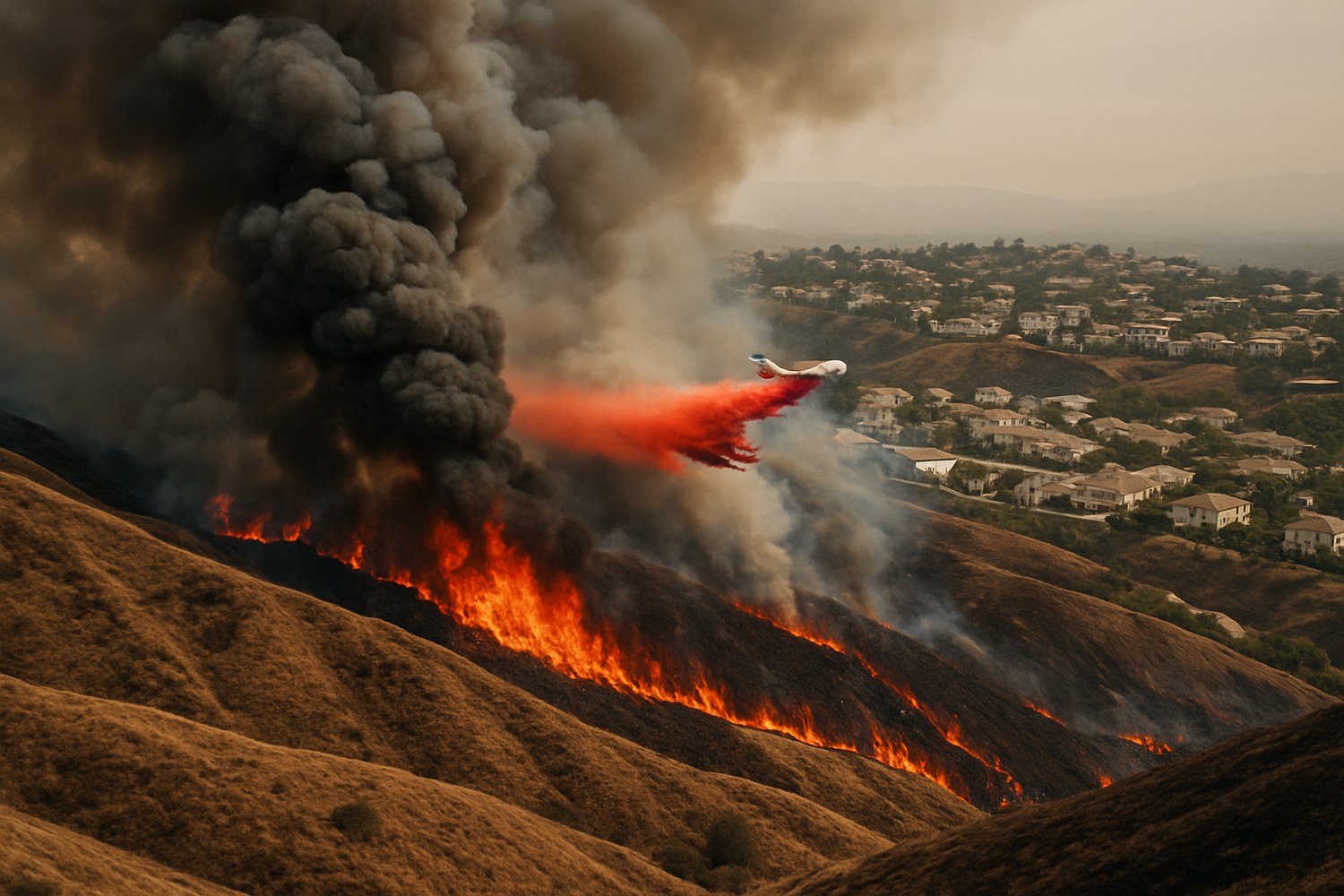
A fast-moving, wind-driven brush fire exploded across 4,176 acres of Riverside County on Friday, April 3, 2026, forcing thousands of residents near Moreno Valley to evacuate as Santa Ana winds gusting up to 55 mph fanned the flames toward populated neighborhoods. The Springs Fire — named for its origin on Gilman Springs Road — grew from just 5 acres to over 4,000 in a matter of hours, making it the first major wildfire of California’s 2026 fire season.
Interactive Fire Map
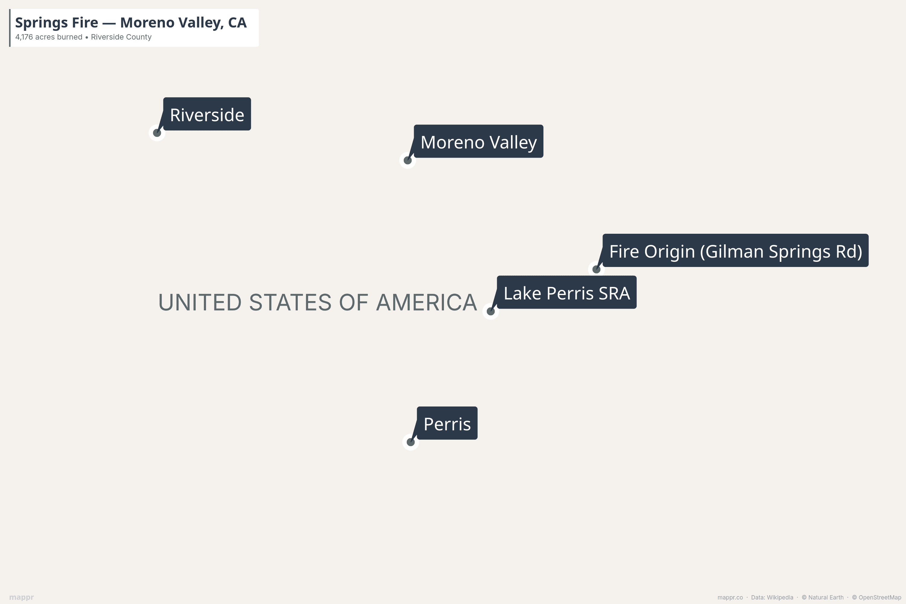
Explore the fire origin, approximate burn area, evacuation zones, and key locations affected by the Springs Fire on the interactive map below. Click markers for details.
What Happened
The Springs Fire was reported at approximately 11:00 AM on Friday, April 3, in the 15900 block of Gilman Springs Road, just east of Moreno Valley. Initially estimated at just 5 acres, the fire exploded under the influence of powerful Santa Ana winds, reaching 1,500 acres by 1:30 PM and exceeding 3,500 acres by late afternoon.
The blaze spread westward toward Lake Perris State Recreation Area, which was evacuated and closed, and crept dangerously close to residential neighborhoods including Moreno Valley Ranch and homes along Championship Drive and Ryder Way — at one point coming within just 200 yards of houses.
Moreno Valley College was evacuated in the middle of the day, with all students and faculty forced to leave campus. Meanwhile, 2,200 homes were placed under mandatory evacuation orders and another 4,300 homes received evacuation warnings.
Key Facts
- Fire Name: Springs Fire
- Location: Gilman Springs Road, east of Moreno Valley, Riverside County, CA
- Size: 4,176 acres (~16.9 km² / 6.3 square miles)
- Containment: 95% (as of April 5, 2026)
- Started: ~11:00 AM, Friday, April 3, 2026
- Cause: Under investigation
- Injuries: None reported
- Structures Damaged: None — no structures burned or destroyed
- Evacuations: 2,200 homes under orders; 4,300 under warnings (peak)
- Personnel: 260+ firefighters, multiple air tankers and helicopters
- Distance from LA: ~64 miles (103 km) east
Static Map: Fire Location
The map below shows the fire’s location east of Moreno Valley, near Lake Perris State Recreation Area in Riverside County.
Timeline: How the Fire Unfolded
- 11:00 AM, April 3: Fire reported at 15900 Gilman Springs Road — initially 5 acres
- 1:30 PM: Rapid growth to 1,500 acres; evacuation orders issued for multiple zones
- 4:00 PM: Fire reaches 3,500 acres, 5% contained; road closures enforced
- 6:48 PM: Mapped at 4,176 acres; 2,200 homes under evacuation orders
- 10:10 PM: Containment rises to 25% as winds begin to ease
- April 4 morning: Fire 45% contained; no overnight growth
- April 4 afternoon: Containment reaches 75%; most evacuation orders lifted
- April 4, 6 PM: 95% contained; all evacuation orders and warnings lifted
Evacuation Zones
At the peak of the emergency on Friday evening, the following Riverside County evacuation zones were under mandatory orders:
- MOE-0507-A, MOE-0507-B
- MOE-0641-A, MOE-0641-B
- MOE-0744, MOE-0747-A, MOE-0747-B
- MOE-0823-A, MOE-0823-B
- RVC-0825-A, RVC-0825-B
An evacuation shelter was opened at Valley View High School (13135 Nason Street, Moreno Valley), with animal shelters available at 581 S. Grand Ave. in San Jacinto and 14041 Elsworth St. in Moreno Valley.
By Saturday evening, April 4, all evacuation orders and warnings had been lifted as firefighters brought the blaze under control.
Why It Spread So Fast: Santa Ana Winds
The Springs Fire’s explosive growth was driven by Santa Ana winds — hot, dry easterly winds that funnel through mountain passes and canyons across Southern California. On April 3, gusts reached 45–55 mph in Riverside County, creating extreme fire behavior and pushing the fire rapidly westward through dry brush toward populated areas.
The National Weather Service had issued a High Wind Warning for much of the region, with the combination of strong winds, low humidity, and dry vegetation creating what fire officials called a “critical fire weather pattern.”
Winds began to ease Friday evening and into Saturday, allowing crews to make significant progress. Natural equestrian trails in the area also helped firefighters access the fire and build effective containment lines, according to Cal Fire spokesperson Terra Fernandez.
Dual Fire Threat: Crown Fire in LA County
The Springs Fire wasn’t alone. At almost the same time, the Crown Fire ignited in the Acton area of northern Los Angeles County, burning 280 acres. That fire was also driven by Santa Ana winds but moved away from populated areas and reached 74% containment by Friday night.
The simultaneous outbreaks stretched firefighting resources across Southern California, with crews from multiple agencies coordinating responses on both fires.