Fighting between Thailand and Cambodia has spread across their shared 817-kilometer border since July 2025, centering on disputed Khmer temple sites and unresolved colonial-era boundaries along the Dangrek Mountains. Active clashes have hit provinces on both sides — Surin, Buri Ram, Sa Kaeo, Si Sa Ket, and Ubon Ratchathani in Thailand and Preah Vihear, Banteay Meanchey, Oddar Meanchey, and Battambang in Cambodia — displacing over 500,000 people and damaging the UNESCO-listed Preah Vihear temple.
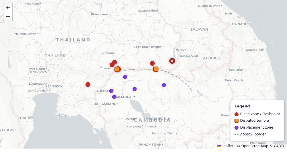
Interactive Map: Border Clash Locations
Explore clash zones, disputed temple sites, and displacement areas along the Thailand-Cambodia border. Click markers for details on each location.
How the Conflict Escalated
The crisis traces to May 2025, when images surfaced of Cambodian soldiers on Hill 745 in Thailand’s Ubon Ratchathani province. Diplomatic talks between Cambodian PM Hun Manet and Thai PM Paetongtarn Shinawatra failed to defuse tensions. On July 23, a Thai soldier was seriously wounded by a landmine near Ta Moan Thom temple — a disputed 11th-century Khmer site on the Surin-Oddar Meanchey border — and full fighting erupted the following day, spreading to at least 12 border sites.
A first ceasefire brokered in Putrajaya, Malaysia on July 28 proved short-lived. The worst escalation came in December 2025, when Thailand launched airstrikes targeting Cambodian artillery positions and BM-21 rockets struck civilian areas in Sa Kaeo province. A second ceasefire — the Kuala Lumpur Peace Accords — was signed December 27 after roughly 20 days of heavy fighting that killed over 100 people.
Key Facts
- Border length: 817 km along the Dangrek Mountains
- Fighting began: July 24, 2025 (preceded by months of tension)
- Root cause: Unresolved colonial-era boundaries from 1904/1907 Franco-Siamese treaties
- Deaths: 101+ confirmed (40+ Thai civilians, 18 Cambodian civilians in December phase alone)
- Displaced: 500,000+ total — 518,611 in Cambodia (peak), ~400,000 evacuated on Thai side
- Ceasefires: Two — Putrajaya (July 28, 2025) and Kuala Lumpur (December 27, 2025)
- Status: Ceasefire formally holding as of April 2026; sporadic violations reported
Affected Border Provinces
Thailand
- Surin — Phanom Dong Rak district was a major fighting hub; artillery hit a workshop building on December 19
- Buri Ram — Border districts evacuated during December escalation; BM-21 rocket strikes on civilian areas
- Sa Kaeo — Homes destroyed by rocket fire; ~400,000 evacuated from this and neighboring provinces
- Si Sa Ket — Kantharalak district directly adjacent to Preah Vihear temple; national park closed
- Ubon Ratchathani — Nam Yuen district / Hill 745 was the initial flashpoint in May 2025
Cambodia
- Preah Vihear — Primary displacement zone; 518,000+ displaced at peak; Thai containers and barbed wire blocking returns
- Banteay Meanchey — Thai shipping containers placed inside Cambodian territory post-ceasefire
- Oddar Meanchey — Heavy displacement from fighting near Ta Moan Thom and border temple sites
- Battambang — Secondary displacement from Banteay Meanchey spillover
- Siem Reap — Received displaced civilians; aid distribution center
The Preah Vihear Temple
The 11th-century Hindu temple sits atop a 525-meter cliff in the Dangrek Mountains. The International Court of Justice awarded sovereignty to Cambodia in 1962, and it was designated a UNESCO World Heritage site in 2008 — a decision Thailand contested and which triggered earlier clashes in 2008–2011.
In this conflict, Thailand accused Cambodia of militarizing the site by installing weapons and surveillance equipment. A January 2026 Cambodian assessment found 420 parts damaged in the December fighting alone, with all five gateway pavilions hit — three described as damaged “almost beyond recognition.” The temple remains closed to visitors with structural collapse risk ahead of the rainy season. Unexploded ordnance has been found on site.
Cambodia has filed a new case at the International Court of Justice over the broader border dispute.
Static Map: Clash and Displacement Zones
The map below shows clash locations (red), disputed temples (orange), and displacement zones (purple) along the 817 km Thai-Cambodian border.
Timeline
- May 17, 2025: Cambodian soldiers spotted on Hill 745; diplomatic talks fail
- July 23, 2025: Thai soldier wounded by landmine near Ta Moan Thom — immediate trigger
- July 24, 2025: Full fighting erupts; spreads to 12+ border sites; ~120,000 civilians flee
- July 28, 2025: First ceasefire (Putrajaya, Malaysia) — short-lived
- Dec 7–8, 2025: Heavy fighting resumes; Thailand launches airstrikes; BM-21 rockets hit Thai civilian zones
- Dec 19, 2025: Artillery hits workshop in Phanom Dong Rak district, Surin
- Dec 27, 2025: Second ceasefire — Kuala Lumpur Peace Accords signed
- Jan 9, 2026: US pledges $45M in aid — $15M for border stabilization, $10M for de-mining
- Feb 18, 2026: Hun Manet accuses Thailand of occupying territory “deep” inside Cambodia
- April 2026: Ceasefire formally holds; ASEAN observers on ground; ~80,000 Cambodians still displaced
Current Status (April 2026)
The December 27 ceasefire is formally holding with no large-scale combat. However, Thailand has placed shipping containers and barbed wire inside areas previously recognized as Cambodian territory across Preah Vihear, Banteay Meanchey, and Pursat provinces — described by Cambodia’s PM as occupation “deep into Cambodian territory.”
ASEAN observer teams are deployed at key flashpoints but have limited enforcement authority. De-mining operations are beginning with US funding, though both sides of the border remain heavily mined. Approximately 80,000 Cambodians are still unable to return home. Nationalist pressure in Thailand ahead of elections continues to raise the risk of re-escalation.
International Response
- Malaysia: Brokered both ceasefires in Putrajaya and Kuala Lumpur
- ASEAN: Deployed Independent Observer Teams to key flashpoints
- United States: $45M aid pledge — border stabilization, de-mining, anti-trafficking
- UN: Secretary-General Guterres welcomed the December ceasefire
- Human Rights Watch: Called on both sides to protect civilians during border clashes
Sources used for this article: